Items Similar to The 1564 Medici Danti Map of California


Want more images or videos?
Request additional images or videos from the seller
1 of 5
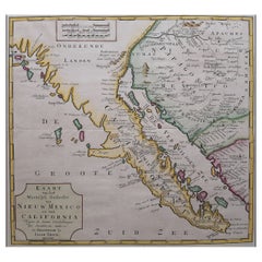
The 1564 Medici Danti Map of California
$135,000
£102,899.35
€118,683.63
CA$191,740.37
A$206,045.19
CHF 110,555.20
MX$2,427,086.43
NOK 1,390,109.04
SEK 1,269,855.63
DKK 886,994.55
About the Item
Florentine, Probably Seventeenth Century
Titled
L’ultime parti note nel Indie occidentali
Dated on the edge of the cartouche: “M.D. LXIII. M.AG” [1564…the month of August]
In the 1560s Cosimo I de’Medici, the powerful Duke of Florence, undertook a major renovation of the Palazzo Vecchio, the venerable palace that to this day dominates the city at the Piazza della Signoria. For the Sala della Guardaroba, literally the wardrobe room, but in fact the storeroom of the Duke’s most precious holdings, Cosimo conceived of a grand decorative project that was to reflect in one space the entire cosmos --both an indication of the Duke’s ambition and an allusion to his name. The plan, supervised by Giorgio Vasari, involved the construction of walnut cabinets to contain the Medici treasures, on the outside doors of which were to be placed large hand-painted maps specially commissioned to document and illustrate the current knowledge of the world. Portraits of famous men were to decorate the tops of the cabinets and two large globes –one representing the terrestrial world, the other celestial—were to descend from openings in the ceiling. The commission for the maps, inspired by Ptolemy’s Geographia, was given to the celebrated mathematician and cosmographer, Fra Egnazio Danti (Perugia 1536-1585 Alatri). Fifty-three maps were ultimately created. Thirty were conceived and executed by Danti between 1563 and 1575. The remaining twenty-three were completed by Stefano Bonsignori between 1576 and 1686. They remain in place in Florence in the room for which they were created.
The present work is an exact-size painted, drawn and inscribed copy of Danti’s map of California –which includes present-day California, Baja California, northwest Mexico, and the southwestern part of the United States, as well as a portion of the Pacific Ocean and, at the extreme left, Japan. Its date of execution is uncertain. The inscribed date of August 1564 is that of Danti’s original. The present work, clearly drawn in the presence of the map in the Palazzo Vecchio, would seem to be slightly later, most likely from the seventeenth century. It is the only such work known and appears to be otherwise undocumented and unique. Furthermore both the present map and the one in Florence have been ignored in the extensive history of the cartography of California, which has focused on printed maps. It is a rare, beautiful, and fascinating document of the early exploration of the Americas.
In the preparation of his map, Danti relied not only on published maps and atlases, but on manuscripts and literary reports by travelers and explorers. The most geographically accurate regions are those on the coast, which by 1564 had been visited by such figures as Francisco de Ulloa and Juan Rodriguez Cabrillo and recorded in printed maps by Mercator, Ortelius, and Battista Agnese. Specifically designated are places well-known to us today from Monterey Bay through Los Angeles to San Diego. The names inscribed on the map are those current in 1564. For example, San Diego was known as San Miguel (on the map as “P.[orto] di S. Michele”) from its naming by Cabrillo in 1542 until Sebastian Vicaino surveyed the coast in 1602, bestowing its current name. The area of Los Angeles is designated “P. del Fuego” and it was indeed known as the Bahia de los Fumos or Bahia de Fuegos (Bay of Smoke or Bay of Fires) from the smoke and fires set by Indians hunting game on the hillsides of what is now San Pedro Bay.
The inland areas of the southwest are, on the other hand, derived from literary accounts –from Marcos de Niza and, in particular, that of the Coronado Expedition of 1540-42. For that reason, the location of many Indian settlements is generic if not fanciful. For example, while Tiguex is in New Mexico, Quivira –visited by Coronado in 1541 and placed on the map as if it were in California-- is believed to have been located near the great bend of the Arkansas river in central Kansas.
The present map is a unique document of the knowledge of California in Europe –and specifically at the Medici court—in 1564, the year of the death of Michelangelo, and fewer than seventy-five years after the landing of Columbus.
Below are some of the place-names inscribed on the map, together with their modern equivalents:
West Coast of California (North to South)
Sierra Nevada = Santa Cruz Mountains
C. Nevado = Cabo de Nieve = Cypress Point (Pebble Beach) or Point Pinos
P. de totos Santos = Todos Santos = Cojo Anchorage
C. Galeras = Cabo del Galera = Point Conception
P. del Fuego = Bahia de los Fumos or Fuegos = San Pedro Bay (Los Angeles)
P. di San Michele = San Miguel = San Diego
C. de Crus = Cabo de Cruz = Punta Banda, Baja
C. del Ingano= Cabo del Engaño (Cape Deceit) = Punta Baja /Baja Point
Ancoras = Punta de las Ancoras = Punta San Juanico (Scorpion Bay)
(Punta di Lea = Part of misreading of “Punta de las Ancoras” as “Punta di Lea” and “Ancoras” on Agnese map of 1542)
Basos = Bajos = The Abreojos
C. de Corintes = Corrientes = Possibly Cabo San Lazaro (Magdalena Bay)
C. Cassinaja = probably Cabo de California = Cabo San Lucas
East Coast of Baja California
C. S. Crus / C S + = Cabo Santa Cruz = La Paz
Mare Vermiglio=Mar Bermejo (Vermillion Sea) Sea of Cortez or Gulf of California
Pacific Islands
I. Giapa[n] / Parte del Ysaola Giapa[n] = Japan
Neg = Nagasaki
Mare del Sur ovvero Pacifico (Southern or Pacific Ocean) = Pacific Ocean
Tropico del Cancro = Tropic of Cancer
Cazones Y = Cazones Isola = San Benito Islands or Natividad
Y. del Riparo = Isla de Riparo = thought to be identical with Ceros or Cedros Island
I.dei Cedri = Isla de Cedros =Cerros or Cedros Island
Inland America
Terra o Mare Incognito = Unknown Land or Sea
Rio di S. Piero y Paolo = Quivira River = Arkansas
Mainland Mexico
Y dei Xalisco – Island of Jalisco
A translation of the central cartouche follows:
The Most Recent Areas Noted in the Western Indies
In the present panel is exhibited the Kingdom of Cibola with the additional and most recent areas discovered toward the West and the North. And since there is no clear knowledge except from the western edge up to Porto Primero and from the northern strip until the city of Tuccano and the Sierra Nevada, the remainder of the space there is left blank not wanting to place anything there for which we do not have certain knowledge until such time that God pleases to give us notice.
This country was discovered by Fray Marcos de Niza, a Franciscan monk, who returning to New Spain, relating many great things to the Court, who then later sent there Francisco Vasquez [de Coronado], who found everything that the Provincial Superior Fray Marcos to have said to be incorrect, and although the names of the cities were true, and that the houses were made of stone, and very high, having four or five floors with comfortable and attractive underground residences, corridors and rooms for the winter.
The afore-mentioned Francisco being to the seven cities of the Kingdom of Cibola asked about the Indians of the Sea, of the West, and of the North, how many there and how far, and they responded not having knowledge of any and that they did not know if there were any on land or on sea.
References Consulted
Warren A. Beck and Ynez D. Haase, Historical Atlas of the American West, Norman-London 1989.
Herbert E. Bolton, ed. Spanish Exploration in the Southwest, 1542-1706 (New York 1916).
Erwin G. Gudde, William Bright California Place Names: The Origin and Etymology of Current Geographical Names (Los Angeles 2010)
Derek Hayes, Historical Atlas of California. Berkeley-Los Angeles-London 2007
Greg Niemann, Baja Legends (San Diego 2002)
Nellie Van de Grift Sanchez: Spanish and Indian place names of California: their meaning and their romance (San Francisco 1922)
Henry Waup Wagner, The Cartography of the Northwest Coast of America to the year 1800 (Berkeley 1937).
For the Palazzo Vecchio map
Ettore Allegri and Alessandro Cecchi, Palazzo Vecchio e I Medici; guida storica (Florence 1980), p. 308, no. 43
Alessandro Cecchi and Paola Pacetti, eds. La Sala delle Carte Georgrafiche in Palazzo Vecchio; “capriccio et invenzione nata dal Duca Cosimo (Florence 2008).
- Dimensions:Height: 44.625 in (113.35 cm)Width: 38.625 in (98.11 cm)
- Medium:
- Movement Style:
- After:Fra Egnazio Danti (1536 - 1586)
- Period:
- Condition:
- Gallery Location:New York, NY
- Reference Number:1stDibs: LU1029066332
About the Seller
5.0
Recognized Seller
These prestigious sellers are industry leaders and represent the highest echelon for item quality and design.
Established in 1997
1stDibs seller since 2012
24 sales on 1stDibs
Typical response time: 7 hours
- ShippingRetrieving quote...Shipping from: New York, NY
- Return Policy
More From This Seller
View AllMap of Palestine or Judea, Illustrating the History of the New Testament
By Rev. Nathan B. Rogers
Located in New York, NY
Pen and ink on paper, laid down on canvas, mounted to wooden scroll bars
Signed and dated lower right: “Drawn by N. B. Rogers August. 1843”
Inscribed with an ownership inscription on the verso: Rev. E. D. Daniels, Palmer, Mass.
Provenance:
Rev. Eugene Davidson Daniels, Palmer, Massachusetts, 1871
This extraordinary manuscript map is a rare survivor of the devotional and educational culture of New England in the first half of the nineteenth century. Although at first glance resembling a large-scale engraving or printed publication, this precisely rendered wall map was entirely drawn by hand, the product of meticulous research by a minister working in isolation in rural Maine. The map shows New Testament era cities, towns, tribal areas, and political borders as well as physical features such as rivers, lakes, mountains, and hills (indicated by half-tone cross-hatching). On to this geographically accurate rendering of the Holy Land, Rogers has located and inscribed significant locales mentioned in the Gospels and has annotated these places with relevant citations from the Bible. He further records these by plotting the travels of Jesus on what resemble a series of trails across the Holy Land. Each is distinguished by a different pattern of dots and dashes – correlated to an explanatory table at the lower right. From this we know that these lines document the “Flight into Egypt and return,” “Travels of Christ from Nazareth to Jerusalem and return,” “Travels from the commencement of his Ministry to the first Passover,” “Travels from the first and the second Passover,” “Travels from Jerusalem to Galilee after the 2nd Passover,” and “Travels from the third Passover to the Crucifixion.”
An inset map of “Jerusalem...
Category
19th Century More Art
Materials
Canvas, Paper, Ink, Pen
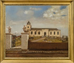
View of St. John’s Cathedral, Antigua
Located in New York, NY
Provenance:
Robert Hollberton, Antigua, ca. 1841
Private Collection, New York
The present painting depicts Old St. John’s Cathedral on the island of Antigua. The church was erected in the 1720s on the designs of the architect Robert Cullen. It measured 130 feet by 50 feet with north and south porches 23 x 20 ½ feet. The tower, 50 feet high with its cupola, was added in 1789. The church was elevated to the status of a cathedral, but disaster struck in the form of an earthquake that destroyed the building on 8 February 1843. A memorandum of that date relates the event:
“On Wednesday, 8th February, 1843, this island was visited by a most terrific and destructive earthquake. At twenty minutes before eleven o’clock in the forenoon, while the bell was ringing for prayers, and the venerable Robert Holberton was in the vestry-room, awaiting the arrival of persons to have their marriage solemnized, before the commencement of the morning service, the whole edifice, from one end to the other, was suddenly and violently agitated. Every one within the church, after the first shock, was compelled to escape for his life. The tower was rent from the top to the bottom; the north dial of the clock precipitated to the ground with a dreadful crash; the east parapet wall of the tower thrown upon the roof of the church; almost the whole of the north-west wall by the north gallery fell out in a mass; the north-east wall was protruded beyond the perpendicular; the altar-piece, the public monument erected to the memory of lord Lavington, and the private monuments, hearing the names of Kelsick, Warner, Otley, and Atkinson, fell down piecemeal inside; a large portion of the top of the east wall fell, and the whole of the south-east wall was precipitated into the churchyard, carrying along with it two of the cast-iron windows, while the other six remained projecting from the walls in which they had been originally inserted; a large pile of heavy cut stones and masses of brick fell down at the south and at the north doors; seven of the large frontpipes of the organ were thrown out by the violence of the shock, and many of the metal and wooden pipes within displaced; the massive basin of the font was tossed from the pedestal on which it rested, and pitched upon the pavement beneath uninjured. Thus, within the space of three minutes, this church was reduced to a pile of crumbling ruins; the walls that were left standing being rent in every part, the main roof only remaining sound, being supported by the hard wood pillars.”
The entrance from the southern side into the cathedral, which was erected in 1789, included two imposing statues, one of Saint John the Divine and the other of Saint John the Baptist in flowing robes. It is said that these statues were confiscated by the British Navy from the French ship HMS Temple in Martinique waters in 1756 during the Seven Years’ War and moved to the church. The statues are still in situ and can be seen today, much as they appeared in Bisbee’s painting, but with the new cathedral in the background (Fig. 1).
Little is known of the career of Ezra Bisbee. He was born in Sag Harbor, New York in 1808 and appears to have had a career as a political cartoonist and a printmaker. His handsome Portrait of President Andrew Jackson is dated 1833, and several political lithographs...
Category
19th Century Old Masters Landscape Paintings
Materials
Canvas, Oil
Seven Scenes from the Life of Apollo
By Jacopo Guarana
Located in New York, NY
Attributed to
Jacopo Guarana
(Verona 1720 – 1808 Venice)
Canvas, unsigned
The Deeds of Apollo
Provenance: Suida-Manning Collection
These seven scenes are brilliant evocations o...
Category
18th Century and Earlier Baroque Figurative Paintings
Materials
Oil
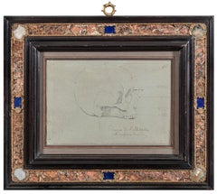
Raphael’s Skull
Located in New York, NY
Provenance:
Ettore Calzone Collection, Rome, by 1912.
Exhibited:
“Raffaello: L’Accademia di San Luca e il mito dell’Urbinate,” Accademia Nazionale di San Luca, Rome, 21 October 2020...
Category
19th Century Old Masters Figurative Drawings and Watercolors
Materials
Pencil, Paper
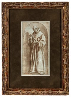
Study of a Franciscan Saint, probably San Diego de Alcalá
Located in New York, NY
Provenance: Ivan E. Phillips, Montreal and New York, until 2023.
The brothers Bartolomé Carducho and Vicente Carducho, both born and trained in Florence, settled in Spain where they made their careers. Vicente worked on numerous commissions for both the church and the Spanish court...
Category
17th Century Old Masters Drawings and Watercolor Paintings
Materials
Paper, Chalk, Ink, Pen
The Archangel Gabriel
By Cristobal de Villalpando
Located in New York, NY
Provenance: Private Collection, Cranston, Rhode Island (by the 1950s?); by family descent until sold at:
Bill Spicer Auction, North Kingstown, Rhode Island, 26 January 2011; where a...
Category
Late 17th Century Old Masters Figurative Paintings
Materials
Canvas, Oil
You May Also Like
Northern Italy: A 16th Century Hand-colored Map by Abraham Ortelius
By Abraham Ortelius
Located in Alamo, CA
This is a framed 16th century hand-colored copperplate map of northern Italy entitled "Veronae Urbis Territorium a Bernardo Bragnolo Descriptium" by Abraham Ortelius from his atlas "Theatrum Orbis Terrarum", which was the first modern atlas of the world, with the first volume published in 1570. This map was part of a subsequent volume, published in Antwerp in 1584. It was based on an earlier map by Bernardo Brognoli.
This beautiful map of northern Italy is focussed on Verona and its environs, including Mantua. Lake Garda and the South Tyrol mountains are prominently depicted. There is a very large striking cartouche in the upper left and a decorative distance scale in the lower right.
This striking hand-colored map of northern Italy is presented in a gold-colored wood frame and an olive green-colored mat. It is glazed with UV conservation glass. All mounting materials used are archival. The frame measures 21.5" high by 28" wide by 0.75" deep. There is a central vertical fold, as issued, with slight separation of the lower portion of the fold. There are faint spots in the upper and right margins, but the map is otherwise in very good condition.
Abraham Ortelius (also known as Ortels, Orthellius, and Wortels) (1527-1598) was a Dutch cartographer, geographer, and cosmographer. He began his career as a map colorist. In 1547 he entered the Antwerp guild of St Luke as an "illuminator of maps". He had an affinity for business from an early age and most of his journeys before 1560, were for business. He was a dealer in antiques, coins, maps, and books.
His business income allowed him to acquire an extensive collection of medals, coins, and antiques, as well as a large library of books...
Category
16th Century Old Masters Landscape Prints
Materials
Engraving

Antique Map of Asia
in Frame, circa 1739
Located in Langweer, NL
Antique map titled 'Asia Dividida em suas Regioens & Principaes Estados'. Rare and uncommon map of Asia. Signed '1739'. Source unknown, to be determined.
...
Category
Antique Mid-18th Century Maps
Materials
Paper

$615 Sale Price
35% Off
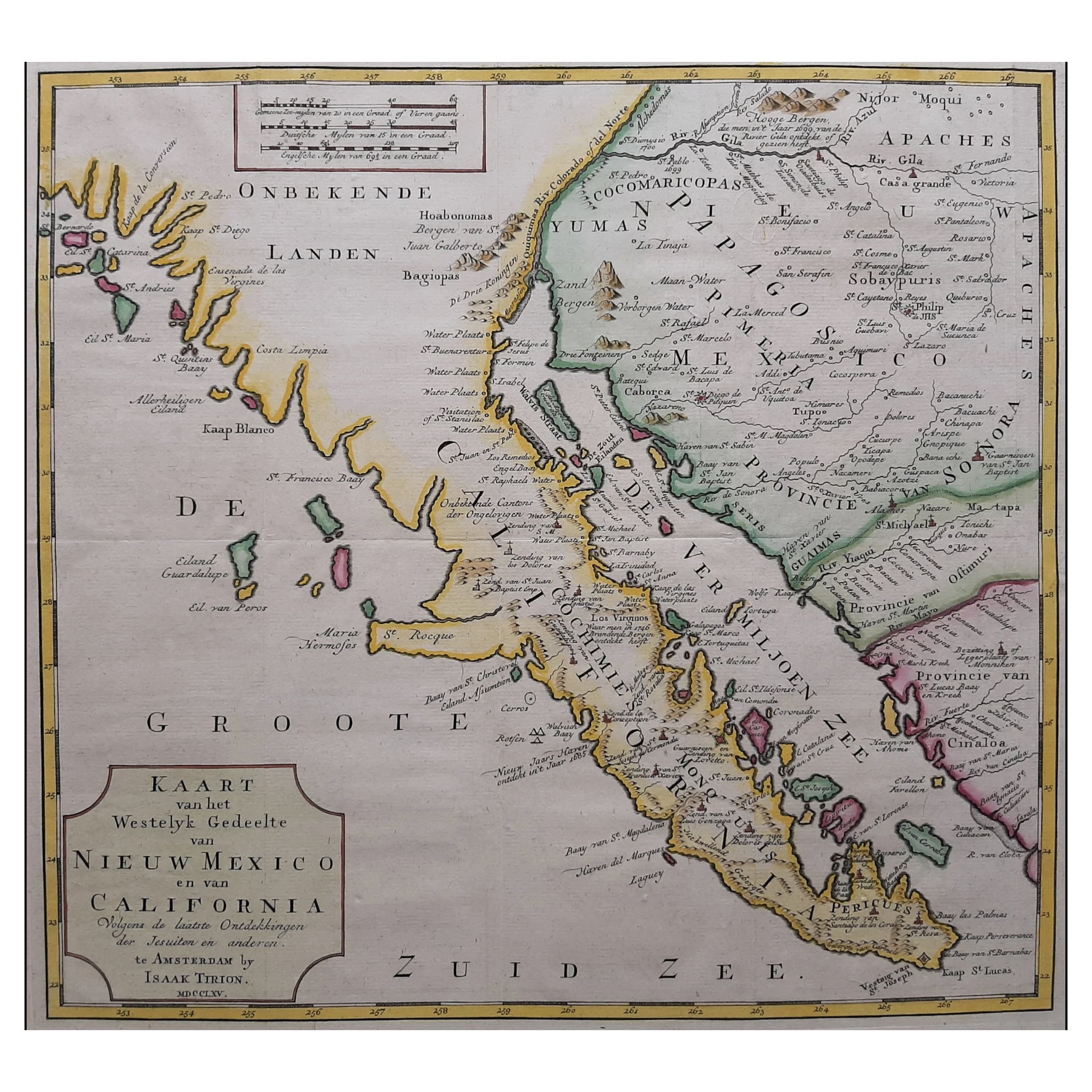
Original Antique Map of the Western Part of NEW MEXICO
CALIFORNIA
Located in Langweer, NL
Title: "Map of the Western Part of NEW MEXICO and CALIFORNIA According to the Latest Discoveries by the Jesuits and Others"
Description:
This exquisite original Dutch map, titled "...
Category
Antique 1760s Maps
Materials
Paper
$1,230 Sale Price
20% Off
Map of the World: An Original 18th Century Hand-colored Map by E. Bowen
Located in Alamo, CA
This is an original 18th century hand-colored map entitled "A New & Correct Chart of All The Known World Laid down according to Mercator's Projection" by Emanuel Bowen. It was published in 1744 in London in John Harris's "Navigantium atque Itinerantium Bibliotheca" or "A Complete Collection of Voyages and Travels". This highly detailed and colorful map depicts the world. as it was known in the mid 18th century. A majority of the northern and central portions of Canada and America are left blank due to the purity of knowledge at the time this map was published.
The map is embellished with four Compass Roses in the lower left, lower center, lower right and center, along with many rhumb lines. There a is a decorative title cartouche in the upper left. This colorful, attractive, historical and interesting 1744 map presents the entire world on Mercator's projection as it was understood in the middle part of the 18th century, before the landmark explorations of Captain’s Cook, Vancouver, Wilkes and others. It is an example of a nautical chart, a type of map that was designed specifically for use by mariners. The map is centered on the equator and includes both the Eastern and Western Hemispheres. The continents of North America, South America, Europe, Africa, and Asia are depicted, as well as various islands in the Atlantic, Pacific, and Indian Oceans. The map is laid out according to the Mercator projection, a type of cylindrical map projection that was developed in the 16th century by Flemish cartographer Gerardus Mercator. This projection has the advantage of preserving angles and shapes, making it useful for navigation. The map presents a paucity of inland detail, particularly for the Americas, but major cities, geographical landmarks, and regions are included. Ocean currents and Tradewinds are identified, as well as the magnetic declination lines or magnetic variance, which refers to the difference between true north and compass north. The continents are color coded, enhancing the beauty of this map. The three compass roses indicate the directions of the cardinal points.
The depiction of the western coast of America, the Pacific and Australia are interesting. There was very little exploration of Australia between the navigations of William Damper in 1699 and Tobias Furneaux in 1773. Most of the maps detail relies on the 17th century Dutch expeditions to Australia's western coast, by Abel Tasman and William Janszoon. Van Diemen's Land (Tasmania) and New Guinea appear connected to the Australian continent. New Zealand appears as a single landmass. North of New Zealand there is a landmass labelled 'Ter d' St. Esprit' which probably represents the New Hebrides Islands. This map precedes the accurate exploration of the South Pacific and east coast of Australia by Captain James Cook later in the 18th century. The map includes ‘Drakes' Port,' the site where Sir Francis Drake supposedly landed in 1579 during his 1579 circumnavigation of the globe. Here he claimed territory for England, restocked, and repaired his vessels. Drake named the region New Albion. The exact location of Drake's Port is a cartographic mystery. Drake's Harbor is believed to be in the region of San Francisco Bay, Bodega Bay, San Pablo Bay...
Category
Mid-18th Century Old Masters Landscape Prints
Materials
Engraving

Cadiz Island: A Framed 17th Century Hand-colored Map from Blaeu
s Atlas Major
By Joan (Johannes) Blaeu
Located in Alamo, CA
This is a 17th century hand-colored map entitled "Insula Gaditana Isla de Cadiz" from Johannes (Joan) Blaeu's Atlas Maior, published in Amsterdam in 1662.
The map provides an excellent plan of Cadiz Island on the southwest coast of Spain, with its harbor, fortifications, agricultural fields and several surrounding salt processing areas. Numerous sailing ships of various sizes are included in and around the harbor and bay, including five large sailing ships, as well as twenty-four smaller ships. There is a small compass rose overlying the bay. The bridge to the mainland from the island is shown on the right. There is an extremely ornate and colorful title cartouche in the lower left, with its mythological figures reminiscent of Raphael’s Galatea fresco at the Villa Farnesina in Rome. The vibrant colors are vividly preserved. The master colorist tried to emulate a painting by using various tones to create a three-dimensional effect.
Blaeu's name is present in the plate in the lower right. Blaeu stated in his description of Cadiz: “The main wealth of the islanders consists of salt, which they harvest, and
the tuna fisheries.”
This 17th century hand-colored map is framed in an ornate, partially textured bronze-colored wood frame and glazed with UV protected conservation glass. There is a vertical center fold, as issued. There is a faint crease in the lower right and faint color offset on the left from the right side of the map, resulting from having been in an atlas for hundreds of years. Small foci of paint are present in the upper portion of the left margin and in the left corner margin. The map is otherwise in very good condition.
Due in large part to their powerful trade empire, the Dutch became known for cartography in the seventeenth century. This period is considered the Golden Age of Dutch cartography. Their publishing houses produced the highest quality work in Europe, particularly those maps and charts of foreign lands, and Dutch map-making set the bar for cartographic accuracy and artistry into the early-eighteenth century. Some of the most well-known cartographers worked in Amsterdam during this period. Perhaps the most famous of these was the Blaeu family. Willem Janszoon Blaeu, set up shop in Amsterdam. His son, Johannes (Joan), succeeded him upon his death in 1638, continuing in his father’s position as Hydrographer to the Dutch East India Company and selling maps to the public. The Blaeu map presses, located near Amsterdam’s Dam Square...
Category
Mid-17th Century Old Masters Landscape Prints
Materials
Engraving

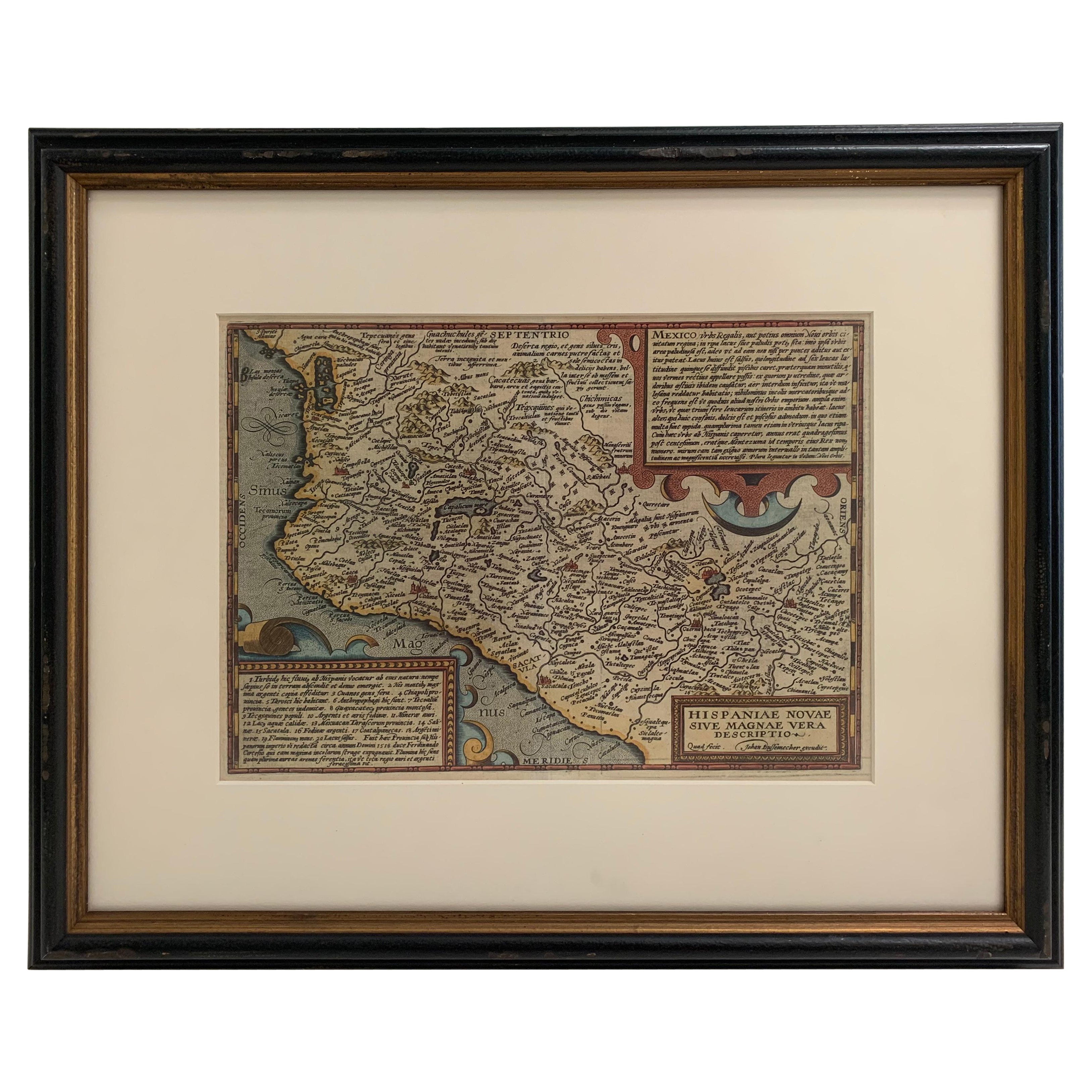
1608 Hispaniae Novae Sive Magnae Vera Descriptio Framed Mexico Map
Located in Stamford, CT
1608 Hispaniae Novae Sive Magnae Vera Descriptio Framed Mexico Map. As found custom black wooden frame/ matting.
This map is based on the work of Abraham Ortelius as is an example o...
Category
Antique Early 1600s Mexican Spanish Colonial Maps
Materials
Glass, Wood, Paper
More Ways To Browse
Ocean Drawing
Pen And Ink Portraits
Pencil Drawings Trees
Orientalist Watercolor Paintings
Landscape Drawings Flowers
Vintage Building Drawings
Beach Scene Watercolor
Watercolor Iris
Watercolor Village Scene
Watercolors Of Venice
Drawing Of A House
Watercolor Flowers Vase
Profile Woman Painting
Watercolor Ocean
Marine Watercolours
Large Landscape Drawing
Paris Fashion Drawing
Watercolor Paintings Of Gardens