Items Similar to 1800
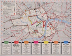
Map of London, Southwark, and parts adjacent
by Darton and Harvey


Want more images or videos?
Request additional images or videos from the seller
1 of 10
Darton and Harvey1800
Map of London, Southwark, and parts adjacent
by Darton and Harvey1800
1800
$1,986.50
£1,450
€1,699.09
CA$2,745.59
A$2,919.13
CHF 1,578.58
MX$34,723.94
NOK 19,773.93
SEK 18,059.48
DKK 12,692.81
About the Item
Darton and Harvey (publisher)
Map of London, Southwark, and parts adjacent (1800)
Engraving
42 x 56 cm
Original price "1 shilling".
About the Seller
4.8
Vetted Professional Seller
Every seller passes strict standards for authenticity and reliability
Established in 2014
1stDibs seller since 2017
364 sales on 1stDibs
Typical response time: 10 hours
- ShippingRetrieving quote...Shipping from: London, United Kingdom
- Return Policy
More From This Seller
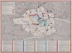
View All1937 Coronation Map for London Transport
Located in London, GB
To see more, scroll down to "More from this Seller" and below it click on "See all from this Seller."
Coronation Arrangements – Map of London (1...
Category
1950s Landscape Prints
Materials
Lithograph
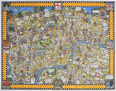
Wonderground Map of London by MacDonald
Max
Gill c. 1924 original poster
By "Leslie MacDonald ""Max"" Gill"
Located in London, GB
To see our other original vintage posters and views of London (including original paintings), scroll down to "More from this Seller" and below it click on "See all from this Seller" ...
Category
1920s Modern Landscape Prints
Materials
Lithograph
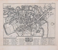
Pieter van der Aa: Map of Cambridge, after David Loggan
By Pieter Van Der Aa
Located in London, GB
Pieter van der Aa (1659-1733), after David Loggan (1634–1692)
Map of Cambridge
12 x 16 cm
Engraving (1727)
An eighteenth-century map of Cambridge eng...
Category
Early 18th Century Realist Prints and Multiples
Materials
Engraving
Map of Cambridge, engraving Pieter van der Aa after David Loggan
By Pieter Van Der Aa
Located in London, GB
Pieter van der Aa (1659 - 1733), after David Loggan (1634 - 1692)
Map of Cambridge
Engraving
12 x 16 cm
An eighteenth-century view of Cambridge, engraved by Pieter van der Aa after ...
Category
Early 18th Century Realist Prints and Multiples
Materials
Engraving

1953 Coronation Map for London Transport
Located in London, GB
To see more, scroll down to "More from this Seller" and below it click on "See all from this Seller."
Coronation Arrangements – Map of London (1...
Category
1950s Landscape Prints
Materials
Lithograph
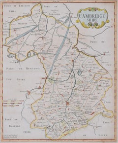
Map of Cambridge 18th century engraving by Sutton Nichols
Located in London, GB
To see more, scroll down to "More from this Seller" and below it click on "See all from this Seller."
Sutton Nichols (1668 - 1729)
Map of Cambridgeshire
Engraving
43 x 36 cm
Signed in plate lower left.
A beautifully coloured 18th century map engraving of Cambridgeshire. The map was produced by Robert Morden for publication in Edward Gibson's 1695 translation of William Camden's Britannia, a topographical and historical survey of Great Britain and Ireland produced to "restore antiquity to Britaine, and Britain to his antiquity" - a most noble aim.
William Camden (1551 - 1623) was an English antiquarian, historian, topographer, and herald, best known as the author of Britannia, the first chorographical survey of the islands of Great Britain and Ireland, and the Annales, the first detailed historical account of the Queen...
Category
18th Century Landscape Prints
Materials
Engraving
You May Also Like
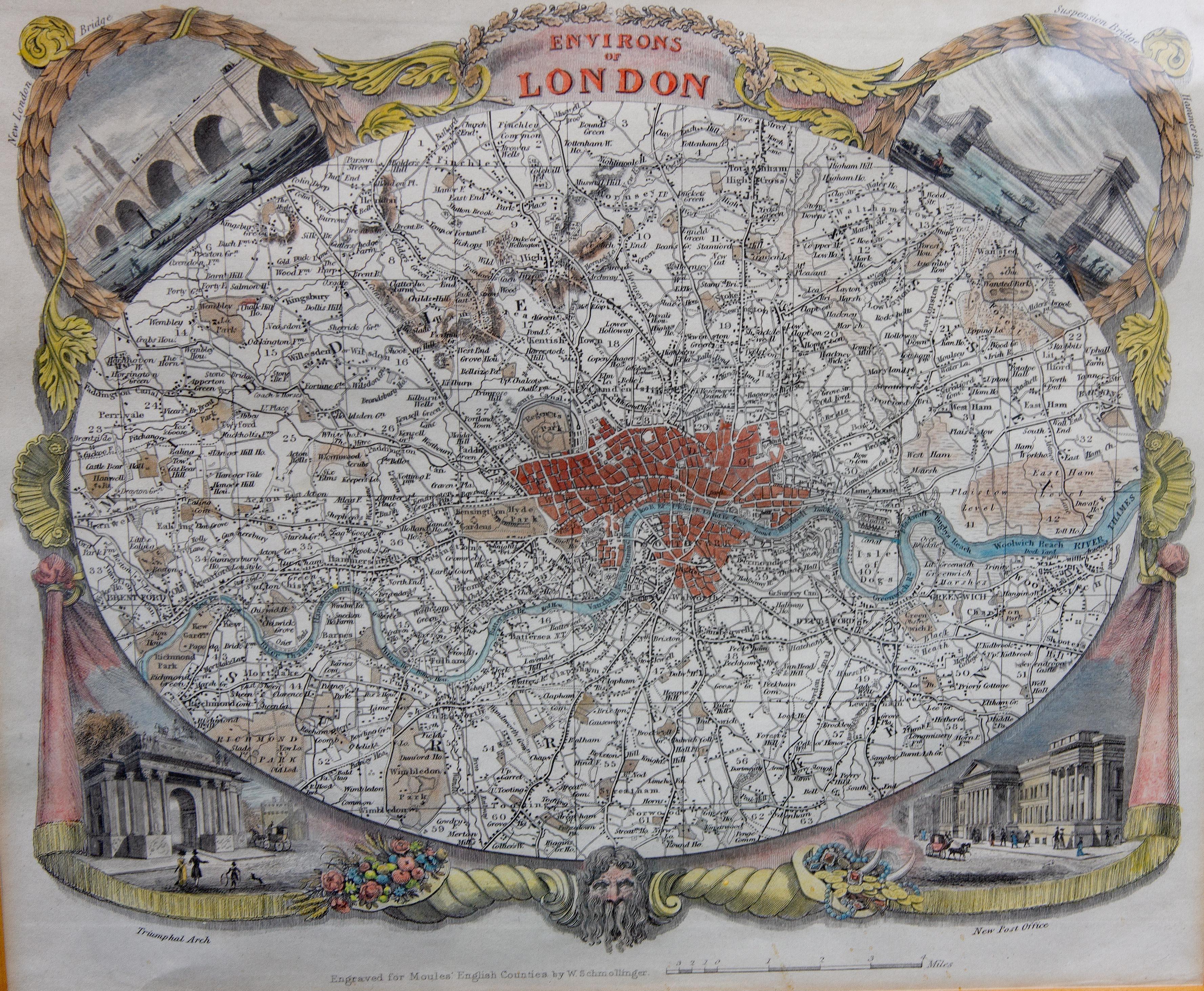
Antique Map of London by Thomas Moule and William Schmollinger
Located in Rochester, NY
Decorative engraved map of London by William Schmollinger for Moule's English County maps. Hand colored. Circa 1830's.
Category
Antique Early 19th Century English Prints
Materials
Paper

Antique Map of the City of London by Balbi
1847
Located in Langweer, NL
Antique map titled 'London'. Original antique map of the city of London. This map originates from 'Abrégé de Géographie (..)' by Adrien Balbi. Published 1847.
Category
Antique Mid-19th Century Maps
Materials
Paper

$190 Sale Price
20% Off
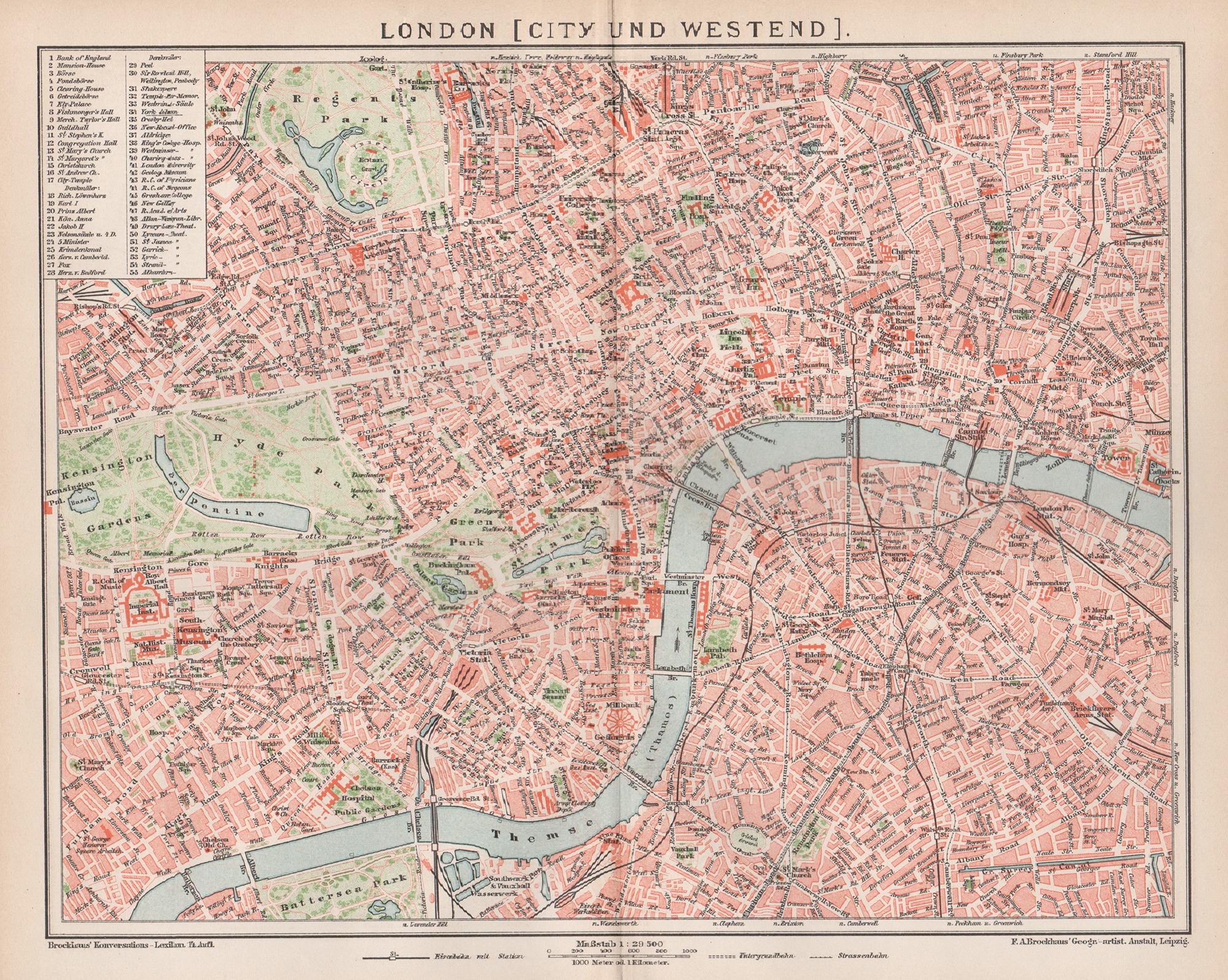
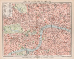
London, City and West End. Antique Map City Plan Chromolithograph, circa 1895
Located in Melbourne, Victoria
'London (City Und Westend)'
Colour lithograph. 1895.
250mm by 305mm (sheet).
Late 19th century German lithograph plan of London, City and West End.
Central vertical fold.
Category
Late 19th Century Victorian More Prints
Materials
Lithograph
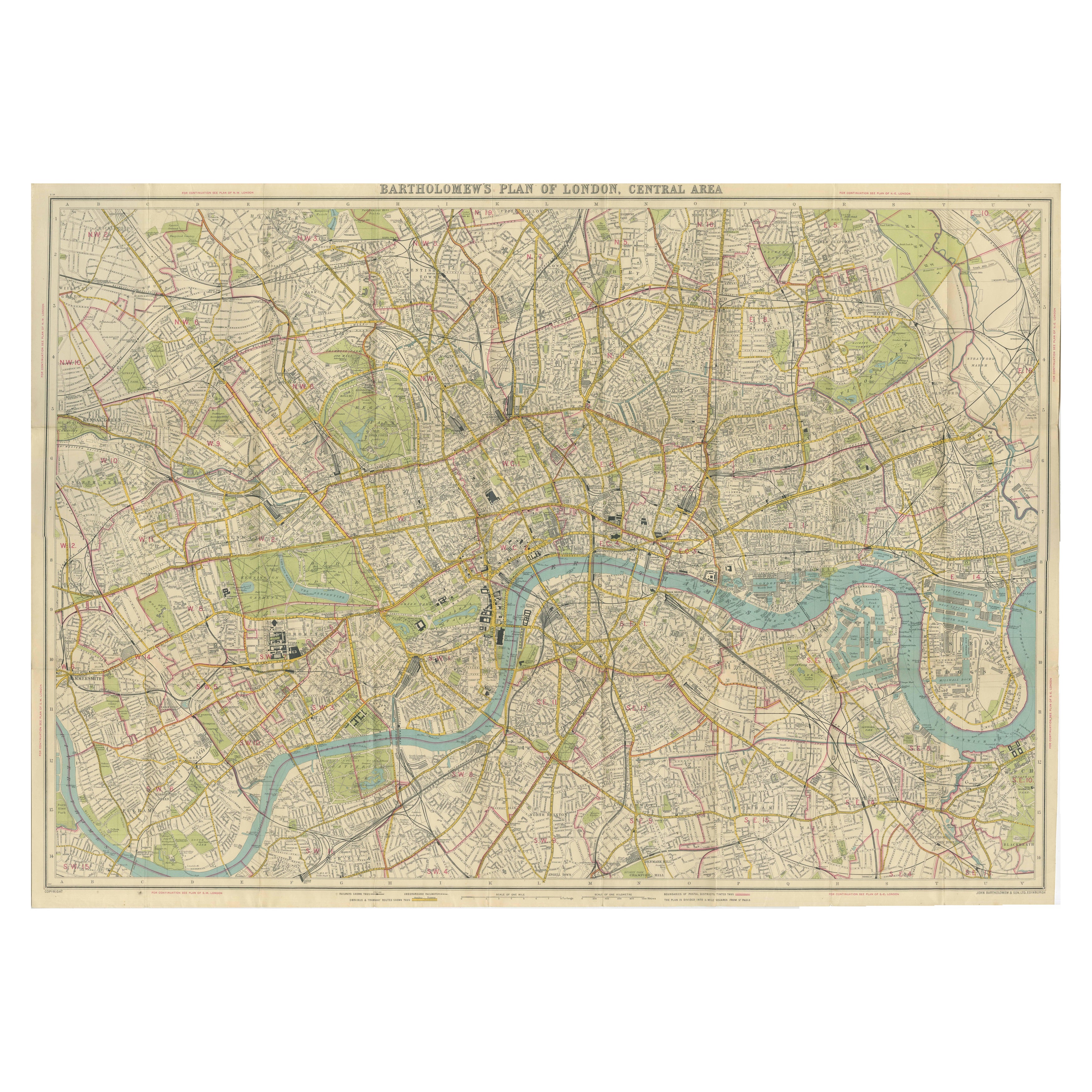
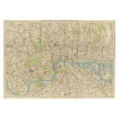
Vintage Map of London – Bartholomew’s Plan of Central London, c.1929
Located in Langweer, NL
London Central Map c.1929 – Bartholomew Antique City Plan
This detailed city plan, titled “Bartholomew’s Plan of London, Central Area,” was published by John Bartholomew & Son, Edin...
Category
Early 20th Century Scottish Maps
Materials
Paper
Antique Map of London by Tirion
1754
Located in Langweer, NL
Antique map titled 'Kaart van Londen enz. en van het naby gelegen land ruim een Uur gaans rondsom dezelve Stad; getrokken uit de groote gemeeten Kaart van Hr. John Rocque'. In the se...
Category
Antique Mid-18th Century Maps
Materials
Paper

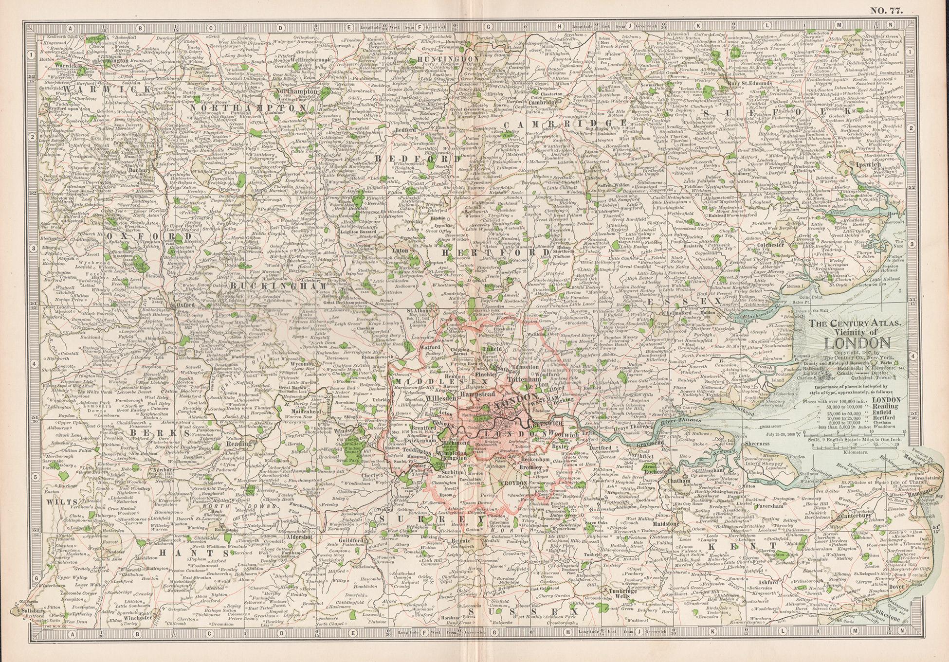
Vicinity of London, England, United Kingdom. Century Atlas antique map
Located in Melbourne, Victoria
'The Century Atlas. Vicinity of London, England, United Kingdom.'
Original antique map, 1903.
Central fold as issued. Map name and number printed on the reverse corners.
Sheet 29.5...
Category
Early 20th Century Victorian More Prints
Materials
Lithograph

More Ways To Browse
Engravings 1800
Antique Engravings London
London Antique Maps
Map Of London
London Map Art Print
Urbain Huchet Lithograph
Victorian Floral Prints
Vintage Black And White Posters
Vintage Mardi Gras
Vintage Mountain Posters
Zuniga Artist
Alex Katz Blue
Alex Katz Dancer
Alvar Sunol Munoz Ramos
Antique Currier Ives Prints
Batik Kate
British Airways Boac
Chicago Poster