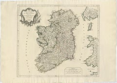
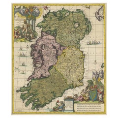
Items Similar to Novissima ac Prae Caeteris Alus Accurat.. - Etching by Frederick de Wit - 1680ca
Want more images or videos?
Request additional images or videos from the seller
1 of 5
Frederick de WitNovissima ac Prae Caeteris Alus Accurat.. - Etching by Frederick de Wit - 1680ca 1680 ca
1680 ca
$1,427.78
£1,062.30
€1,200
CA$1,977.68
A$2,119.05
CHF 1,136.72
MX$25,100.43
NOK 14,339.10
SEK 13,118.06
DKK 9,143.43
About the Item
This double-page etching with contemporary coloring, entitled Novissima ac Prae Caeteris Alus Accuratissima Regni et Insulae Hiberniae, was realized by the cartographer Frederick de Wit for the famous Atlas published in Amsterdam in ca. 1680.
The state of preservation is fair: central fold reinforced in antiquity on the reverse, some ancient reinforcement, some short rips, stains and browning of the paper.
Folio, measures ca. cm 73x51,5
Inscription on the reverse "Foglio 27 / Ibernia "
Frederick de Wit was a cartographer and map-seller who was best known for his atlases and his Dutch town maps. His maps were known for their accuracy and detail, and contributed significantly to the documentation and understanding of the lands explored and discovered in the 17th century. His work had a considerable influence on the diffusion of geographical and cartographic knowledge of the time.
- Creator:Frederick de Wit (1630 - 1706, Dutch)
- Creation Year:1680 ca
- Dimensions:Height: 28.75 in (73 cm)Width: 20.28 in (51.5 cm)Depth: 0.04 in (1 mm)
- Medium:
- Movement Style:
- Period:1680-1689
- Framing:Framing Options Available
- Condition:Insurance may be requested by customers as additional service, contact us for more information.
- Gallery Location:Roma, IT
- Reference Number:Seller: T-1549051stDibs: LU650316393352
Frederick de Wit
Frederick De Wit (1629-1706) was an engraver, cartographer and map dealer who ran a prominent and productive printing business in Amsterdam, founded in 1654 and initially called The Three Crabs and later The White Chart. He published his first atlas in 1662. In 1695 he purchased a large collection of the plates of the prestigious Blaeu publishing business. After his death in 1706, his wife Maria continued in the business for four years before selling it at the auction. A majority of the plates were purchased by Pieter Mortier. His thriving and growing business eventually became Covens
Mortier, one of the largest and most successful cartography and printing businesses of the eighteenth century.
About the Seller
4.9
Platinum Seller
Premium sellers with a 4.7+ rating and 24-hour response times
1stDibs seller since 2017
7,918 sales on 1stDibs
Typical response time: 1 hour
- ShippingRetrieving quote...Shipping from: Grasse, France
- Return Policy
More From This Seller
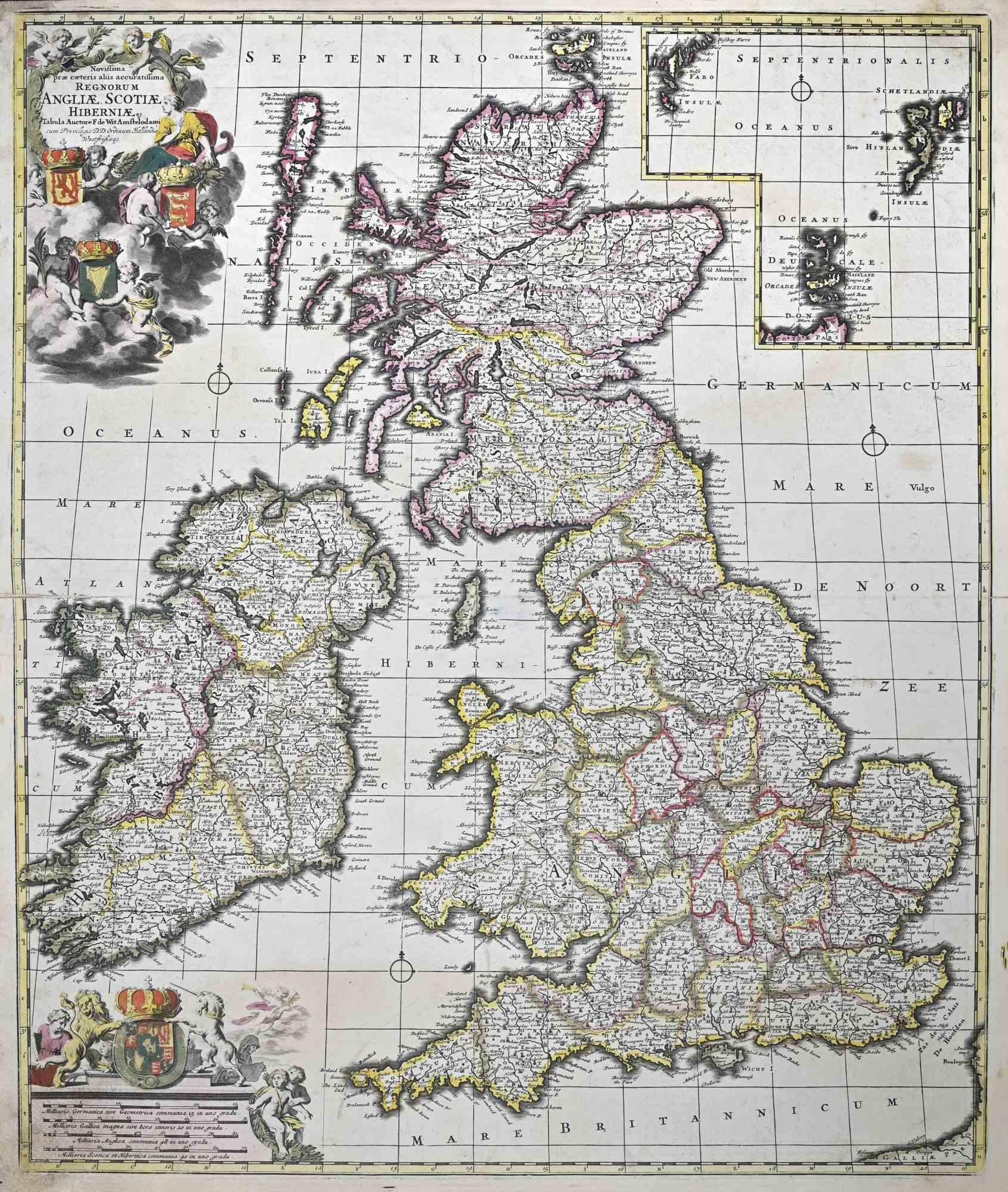
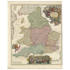
View AllNovissima Prae Caeteris Aliis... - Etching by Frederick de Wit - 1680ca
By Frederick de Wit
Located in Roma, IT
This double-page etching with contemporary coloring, entitled Novissima Prae Caeteris Aliis Accuratissima Regnorum Angliae, Scotiae, Hiberniae, was realized by the cartographer Frede...
Category
1680s Modern Figurative Prints
Materials
Etching
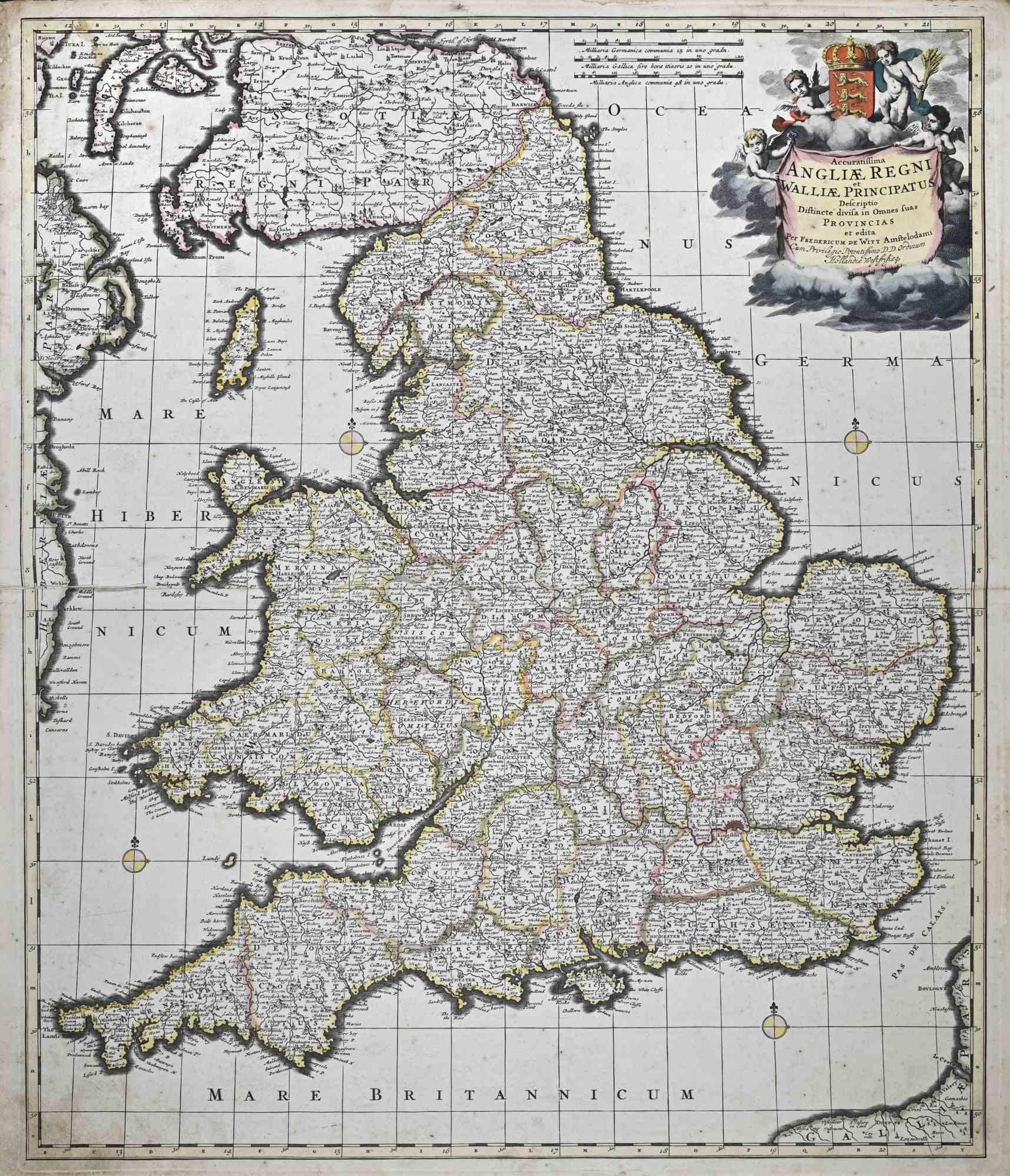
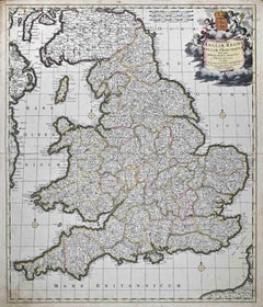
Accuratissima Angliae Regni et Walliae... - Etching by Frederick de Wit - 1680ca
By Frederick de Wit
Located in Roma, IT
This double-page etching with contemporary coloring, entitled Accuratissima Angliae Regni et Walliae Principatus, was realized by the cartographer Frederick de Wit for the famous Atl...
Category
1680s Modern Figurative Prints
Materials
Etching
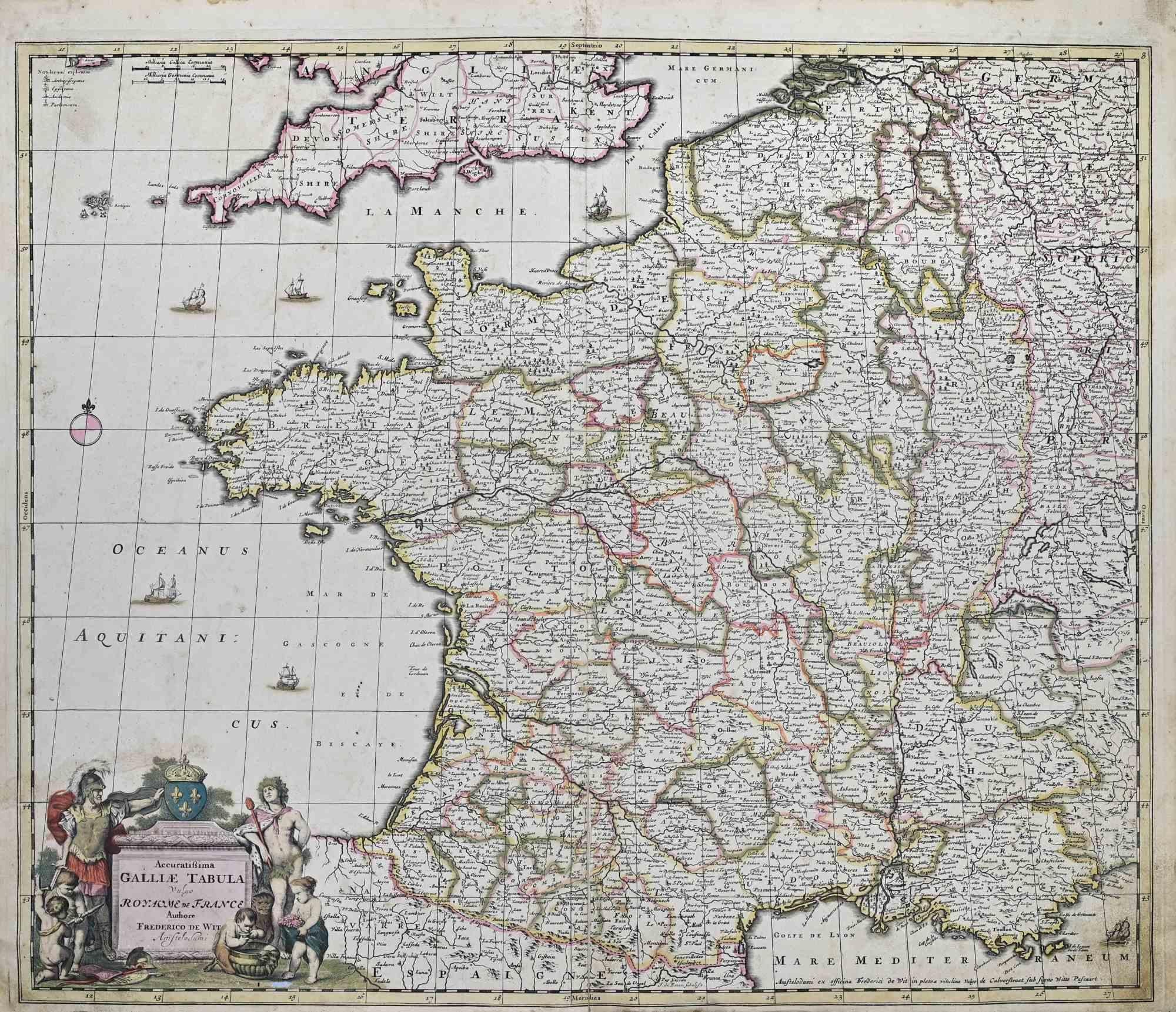
Accuratissima Galliae Tabula - Etching by Frederick de Wit - 1680ca
By Frederick de Wit
Located in Roma, IT
This double-page etching with contemporary coloring, entitled Accuratissima Galliae Tabula [...], was realized by the cartographer Frederick de Wit for the famous Atlas published in ...
Category
1680s Modern Figurative Prints
Materials
Etching

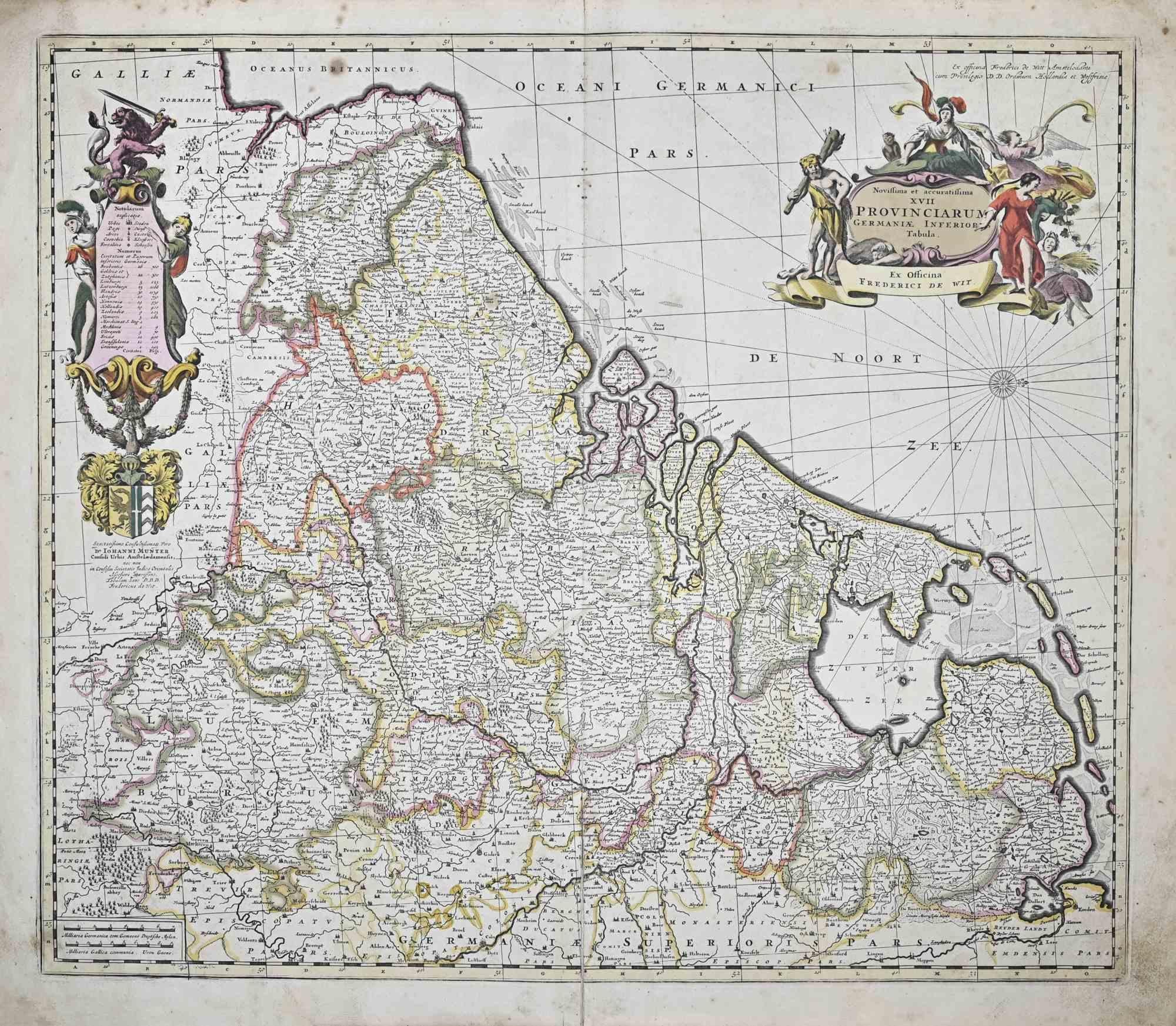
Novissima et Accuratissima XVII ... - Etching by Frederick de Wit - 1680ca
By Frederick de Wit
Located in Roma, IT
This double-page etching with contemporary coloring, entitled Novissima et accuratissima XVII Provinciarum Germaniae Inferior Tabula, was realized by the cartographer Frederick de Wi...
Category
1680s Modern Figurative Prints
Materials
Etching

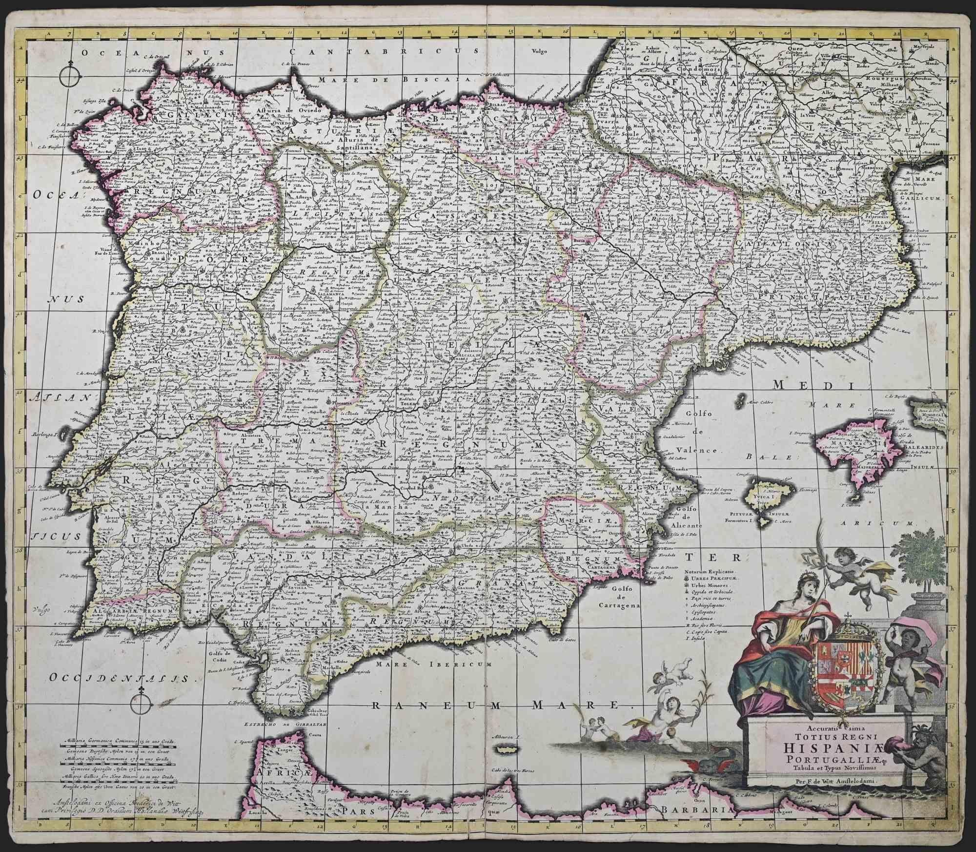
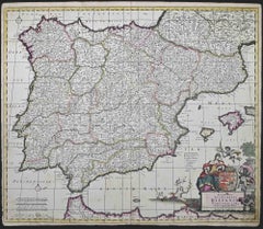
Accuratissima Totius Regni Hispaniae... - Etching by Frederick de Wit - 1680ca
By Frederick de Wit
Located in Roma, IT
This double-page etching with contemporary coloring, entitled Accuratissima Totius Regni Hispaniae Portugalliae, was realized by the cartographer Frederick de Wit for the famous Atla...
Category
1680s Modern Figurative Prints
Materials
Etching
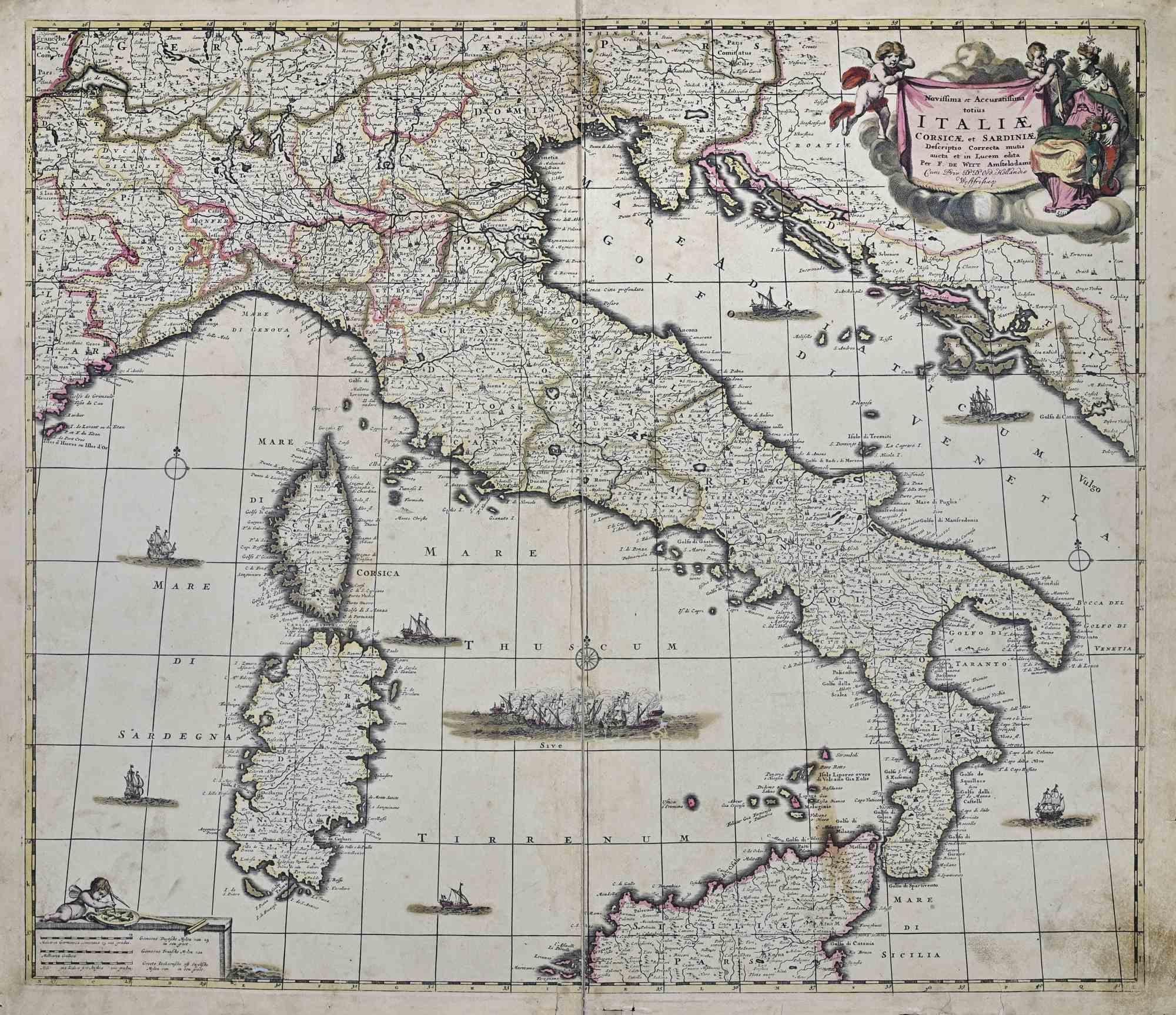
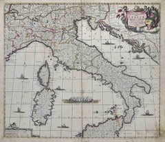
Novissima et Accuratissima Totius.. - Etching by Frederick de Wit - 1680ca
By Frederick de Wit
Located in Roma, IT
This double-page etching with contemporary coloring, entitled Novissima et Accuratissima totius Italiae, Corsicae et Sardiniae, was realized by the cartographer Frederick de Wit for ...
Category
1680s Modern Figurative Prints
Materials
Etching
You May Also Like
Southeastern Ireland: A 17th Century Hand Colored Map by Mercator and Hondius
By Gerard Mercator
Located in Alamo, CA
A 17th century copperplate hand-colored map entitled "The Second Table of Ireland, Udrone" by Gerard Mercator and Jodocus Hondius, published in Amsterdam in 1635 in 'Cosmographicall ...
Category
1630s Landscape Prints
Materials
Engraving

Irlandia – Antique Miniature Map of Ireland, Latin Cartography by Du Val c.1679
Located in Langweer, NL
Title: IRLANDIA – Antique Map of Ireland, Latin Cartography by Du Val c.1650
Description:
This original antique map depicts the island of Ireland under the Latin title “Irlandia” an...
Category
Antique Late 17th Century French Maps
Materials
Paper

Ireland Antique Map – Royaume d’Irlande, De Vaugondy, Venice 1778
Located in Langweer, NL
Antique Map of Ireland – Royaume d’Irlande, Robert de Vaugondy, Venice 1778
Description:
This finely engraved 18th-century map depicts the Kingdom of Ireland under the title Royaume d’Irlande divisé en ses quatre Provinces et subdivisé en Comtés. The island is shown in impressive detail, with the traditional four provinces—Ulster, Connaught, Leinster, and Munster—clearly delineated and subdivided into counties by contemporary outline coloring. Coastal features, rivers, towns, and road networks are rendered with the clarity and balance typical of late Enlightenment French cartography.
The map was drawn by Robert de Vaugondy, one of the most influential mapmakers of the 18th century and royal geographer to the King of France. This Venetian edition was published in 1778 by Paolo Santini, who issued a number of high-quality Italian editions of leading French cartographic works. Santini’s publications are prized for their crisp engraving, generous format, and restrained coloring, making them particularly attractive for framing.
The decorative maritime cartouche, left uncolored as issued, provides a refined visual counterbalance to the densely engraved map surface. Longitude and latitude scales frame the composition, while inset coastal details along the eastern seaboard emphasize Ireland’s maritime orientation and strategic importance during the Georgian period. The overall aesthetic is elegant rather than ornate, lending the map strong decorative appeal for both classic and contemporary interiors.
This map sits at the intersection of political geography and decorative cartography, reflecting Ireland’s administrative structure in the late 18th century while remaining visually calm and highly legible. It works exceptionally well as a stand-alone wall piece in libraries, studies, hallways, or heritage-inspired interiors, and also pairs beautifully with maps of England or Scotland from the same period.
Condition report:
Good antique condition. Light, even age toning throughout. Original centerfold as issued. Minor handling wear and soft creases consistent with age. Contemporary outline coloring well preserved. No major tears or losses.
Framing tips:
This map benefits from a wide mat to emphasize its scale and clarity. Recommended combinations include a dark walnut or ebonized frame with an ivory or light parchment mat for a traditional library look, or a slim black frame with an off-white mat for a cleaner, architectural presentation. UV glass is advised to preserve the original coloring.
Technique: Copper engraving with contemporary outline coloring
Maker: Robert de Vaugondy, published by Paolo Santini, Venice, 1778
Keywords:
antique map of Ireland, antique Ireland map, Royaume d’Irlande map, Robert de Vaugondy Ireland, Santini Venice map, 18th century Ireland map, hand colored antique map, Georgian era cartography, historic Ireland wall map, European antique map, French cartographic school, Italian engraved map, copper engraved map, decorative antique map, neutral antique wall art, classic library wall decor, historic wall decor, heritage interior art, gentleman’s library wall art, study wall decor, old world interior decor, English country house style, refined wall map, vintage European wall art, timeless wall decor, architectural interior art, framed antique map...
Category
Antique 1770s Italian Maps
Materials
Paper
Rare 1690 Map of England by Nicolaes Visscher II – Heptarchy Depicted
Located in Langweer, NL
Map of England 1690 by Nicolaes Visscher II – Heptarchy and Counties Shown
Antique 1690 map of England by Nicolaes Visscher II, showing the Anglo-Saxon Heptarchy and detailed county...
Category
Antique Late 17th Century Dutch Maps
Materials
Paper
$1,618 Sale Price
20% Off
Hibernia Regnum Map by Carel Allard, 1700: Hand-Colored Provinces of Ireland
Located in Langweer, NL
This is a historical map of Ireland created by Carel Allard around 1700, titled "Hibernia Regnum in Quatuor Provincias Ultoniam, Connaciam, Lageniam, et Momoniam". The map is hand-colored and engraved. It includes two large decorative cartouches. The map is part of an atlas by Carel Allard, an Amsterdam-based cartographer.
Here are the detailed points about the map:
Maker: Carel Allard - a prominent Dutch cartographer and publisher from Amsterdam.
Atlas: Source Atlas - Likely part of an atlas published by Carel Allard, but specific title of the atlas isn't mentioned.
Interesting Features
1. Decorative Cartouches: The map features two large, ornate cartouches. One in the upper left depicts a classical figure and British Royal arms...
Category
Antique Early 1700s Maps
Materials
Paper
$1,998 Sale Price
30% Off
Rare and Early Map of the Seventeen Provinces, Published in circa 1640
Located in Langweer, NL
Antique map titled 'Carte Generale des Dixsept Provinces des Pais Bas'. Rare and Early map of the Seventeen Provinces. The Seventeen Provinces were the Imperial states of the Habsbur...
Category
Antique Mid-17th Century Maps
Materials
Paper
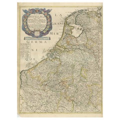
$2,094 Sale Price
20% Off
Free Shipping