Items Similar to Turcicum Imperium - Etching by Frederick de Wit - 1680ca
Want more images or videos?
Request additional images or videos from the seller
1 of 5
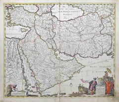
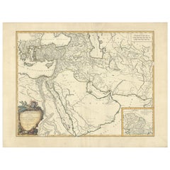
Frederick de WitTurcicum Imperium - Etching by Frederick de Wit - 1680ca 1680 ca
1680 ca
$1,427.78
£1,062.30
€1,200
CA$1,977.68
A$2,119.05
CHF 1,136.72
MX$25,100.43
NOK 14,339.10
SEK 13,118.06
DKK 9,143.43
About the Item
This double-page etching with contemporary coloring, entitled Turcicum Imperium, was realized by the cartographer Frederick de Wit for the famous Atlas published in Amsterdam in ca. 1680.
The state of preservation is fair: central fold reinforced in antiquity on the reverse, rips, stains and browning of the paper.
Folio, measures ca. cm 51,5x59,8
Inscription on the reverse "Foglio 19 / Turchia"
Frederick de Wit was a cartographer and map-seller who was best known for his atlases and his Dutch town maps. His maps were known for their accuracy and detail, and contributed significantly to the documentation and understanding of the lands explored and discovered in the 17th century. His work had a considerable influence on the diffusion of geographical and cartographic knowledge of the time.
- Creator:Frederick de Wit (1630 - 1706, Dutch)
- Creation Year:1680 ca
- Dimensions:Height: 20.28 in (51.5 cm)Width: 23.55 in (59.8 cm)Depth: 0.04 in (1 mm)
- Medium:
- Movement Style:
- Period:1680-1689
- Framing:Framing Options Available
- Condition:Insurance may be requested by customers as additional service, contact us for more information.
- Gallery Location:Roma, IT
- Reference Number:Seller: T-1550431stDibs: LU650316417382
Frederick de Wit
Frederick De Wit (1629-1706) was an engraver, cartographer and map dealer who ran a prominent and productive printing business in Amsterdam, founded in 1654 and initially called The Three Crabs and later The White Chart. He published his first atlas in 1662. In 1695 he purchased a large collection of the plates of the prestigious Blaeu publishing business. After his death in 1706, his wife Maria continued in the business for four years before selling it at the auction. A majority of the plates were purchased by Pieter Mortier. His thriving and growing business eventually became Covens
Mortier, one of the largest and most successful cartography and printing businesses of the eighteenth century.
About the Seller
4.9
Platinum Seller
Premium sellers with a 4.7+ rating and 24-hour response times
1stDibs seller since 2017
7,918 sales on 1stDibs
Typical response time: 1 hour
- ShippingRetrieving quote...Shipping from: Grasse, France
- Return Policy
More From This Seller
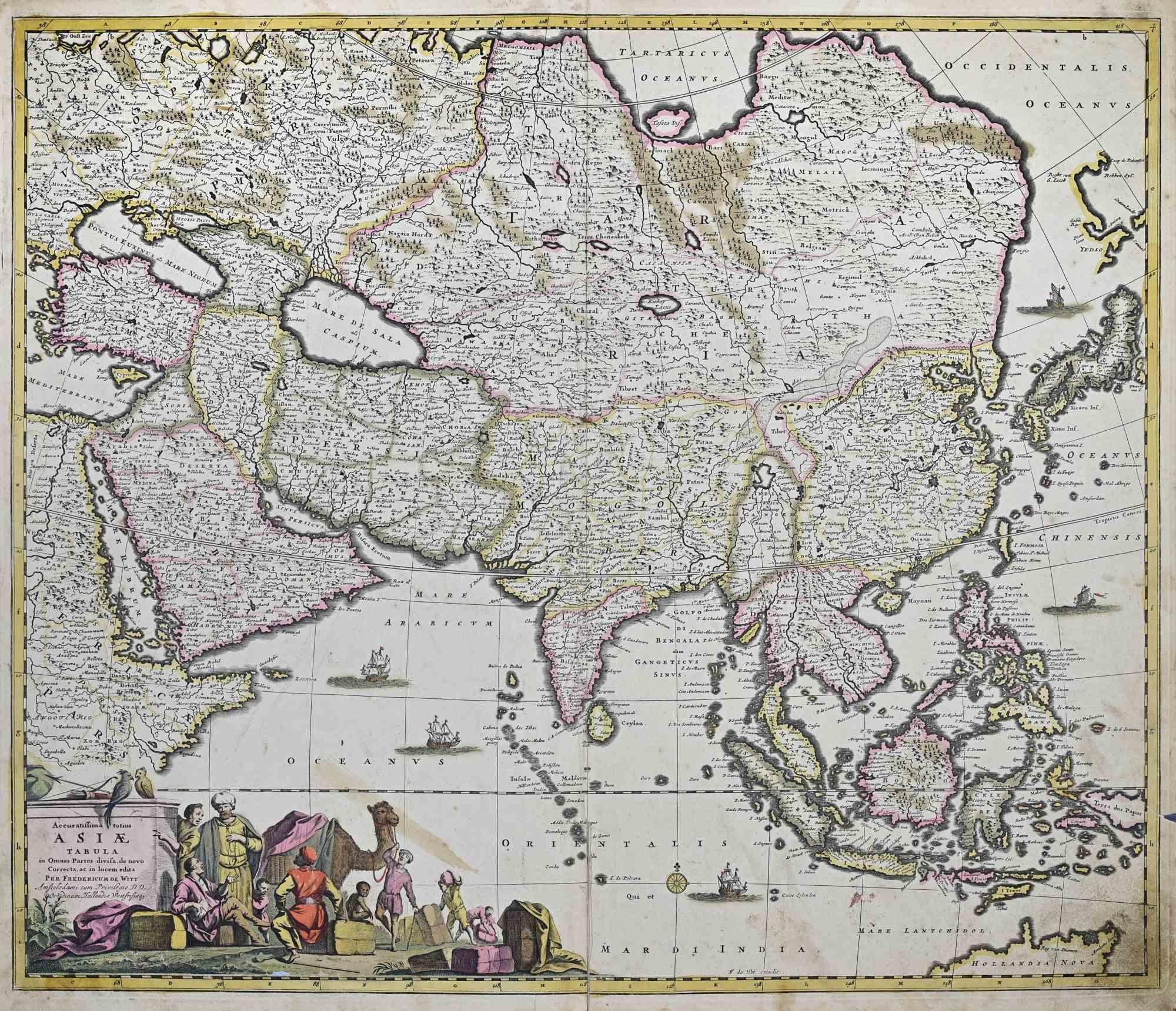
View AllAccuratissima Totius Asiae Tabula - Etching by Frederick de Wit - 1680 ca
By Frederick de Wit
Located in Roma, IT
This double-page etching with contemporary coloring, entitled Accuratissima totius Asiae Tabula, was realized by the cartographer Frederick de Wit for the famous Atlas published in A...
Category
1680s Modern Figurative Prints
Materials
Etching

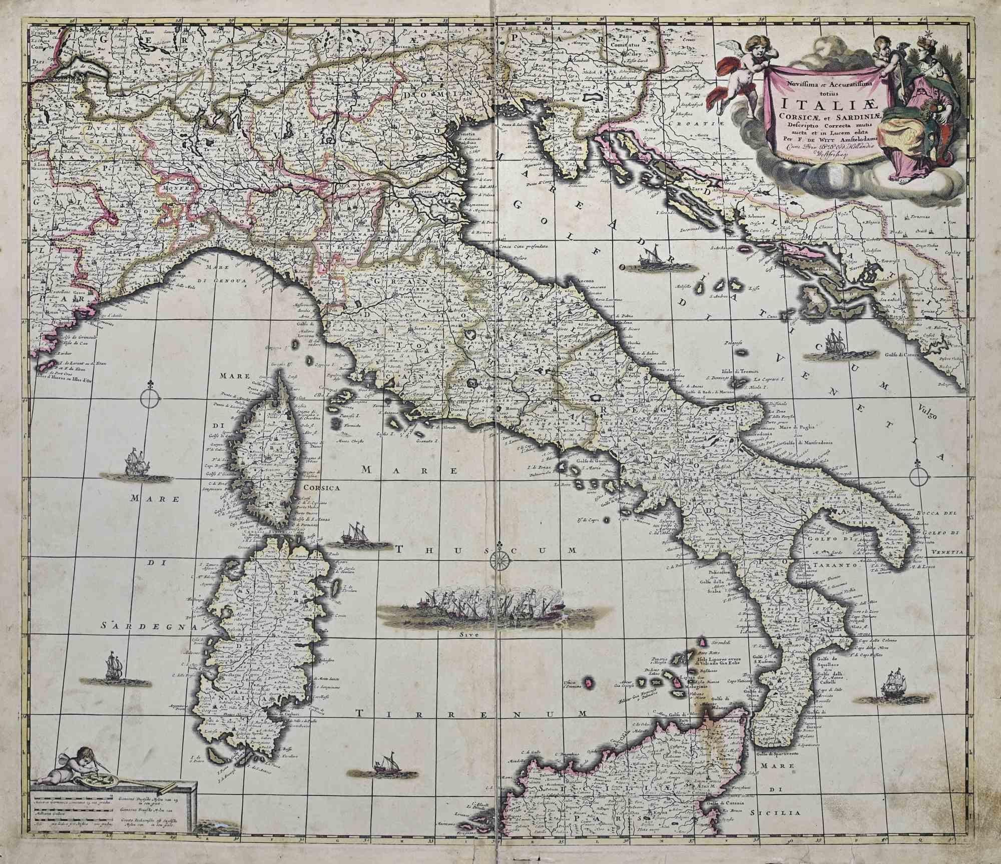
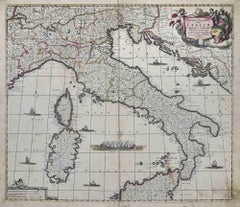
Novissima et Accuratissima Totius.. - Etching by Frederick de Wit - 1680ca
By Frederick de Wit
Located in Roma, IT
This double-page etching with contemporary coloring, entitled Novissima et Accuratissima totius Italiae, Corsicae et Sardiniae, was realized by the cartographer Frederick de Wit for ...
Category
1680s Modern Figurative Prints
Materials
Etching
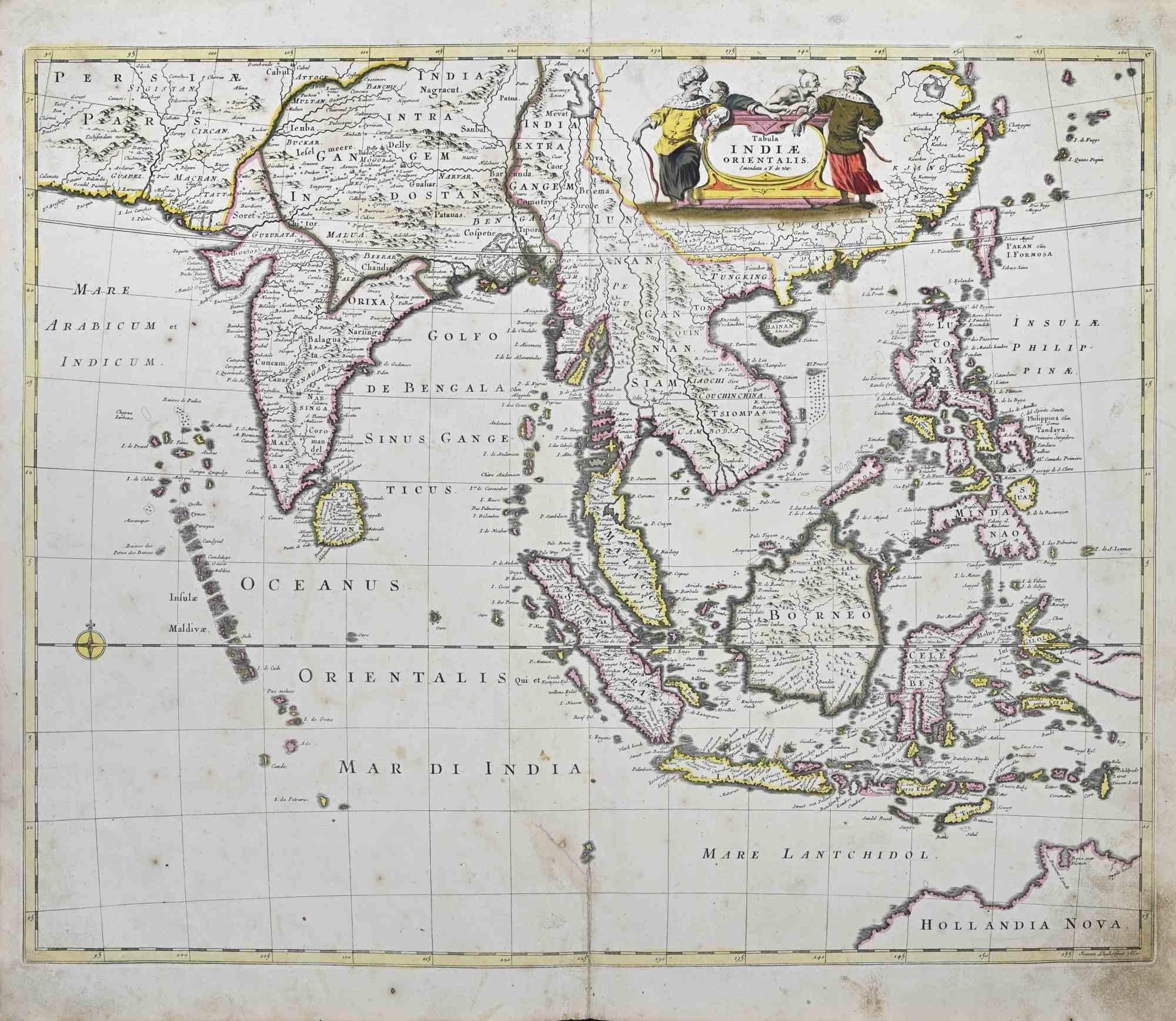
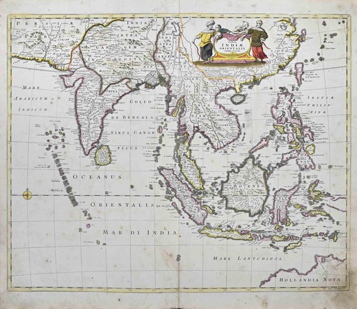
Tabula Indiae Orientalis - Etching by Frederick de Wit - 1680ca
By Frederick de Wit
Located in Roma, IT
This double-page etching with contemporary coloring, entitled Tabula Indiae orientalis, was realized by the cartographer Frederick de Wit for the famous Atlas published in Amsterdam ...
Category
1680s Modern Figurative Prints
Materials
Etching

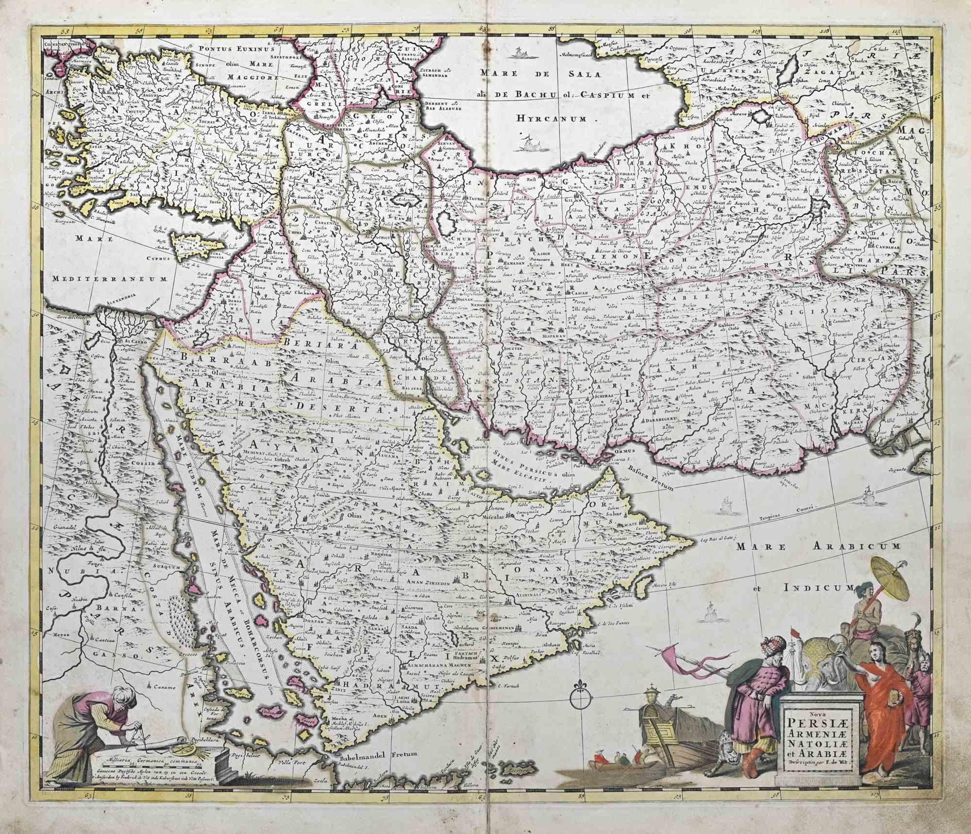
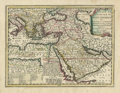
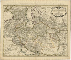
Nova Persiae, Armeniae, Natoliae et Ara.. - Etching by Frederick de Wit - 1680ca
By Frederick de Wit
Located in Roma, IT
This double-page etching with contemporary coloring, entitled Nova Persiae, Armeniae, Natoliae et Arabiae, was realized by the cartographer Frederick de Wit for the famous Atlas publ...
Category
1680s Modern Figurative Prints
Materials
Etching
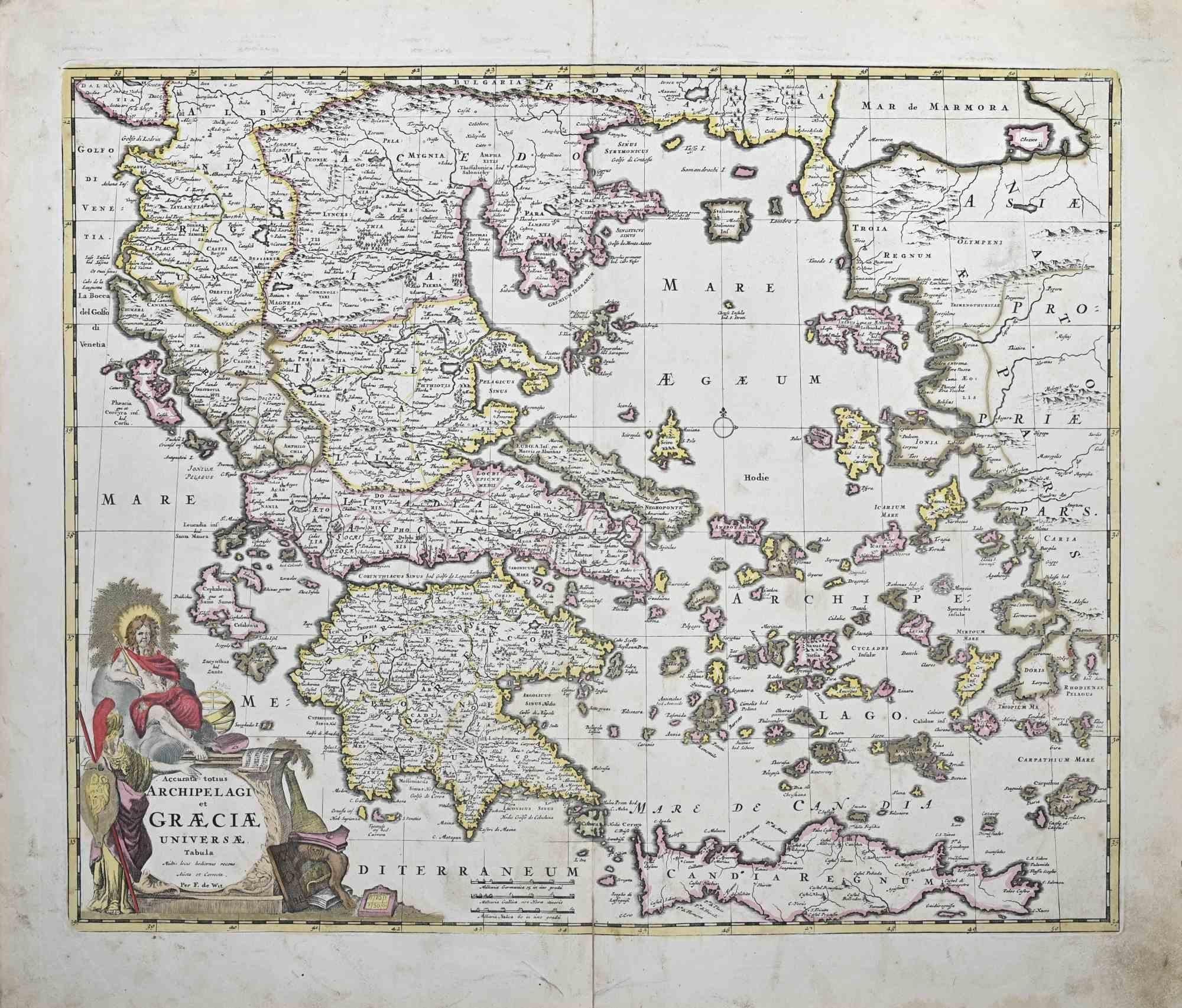
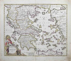
Accurata totius Archipelagi et Graeciae...- Etching by Frederick de Wit - 1680ca
By Frederick de Wit
Located in Roma, IT
This double-page etching with contemporary coloring, entitled Accurata totius Archipelagi et Graeciae Universae Tabula, was realized by the cartographer Frederick de Wit for the famo...
Category
1680s Modern Figurative Prints
Materials
Etching
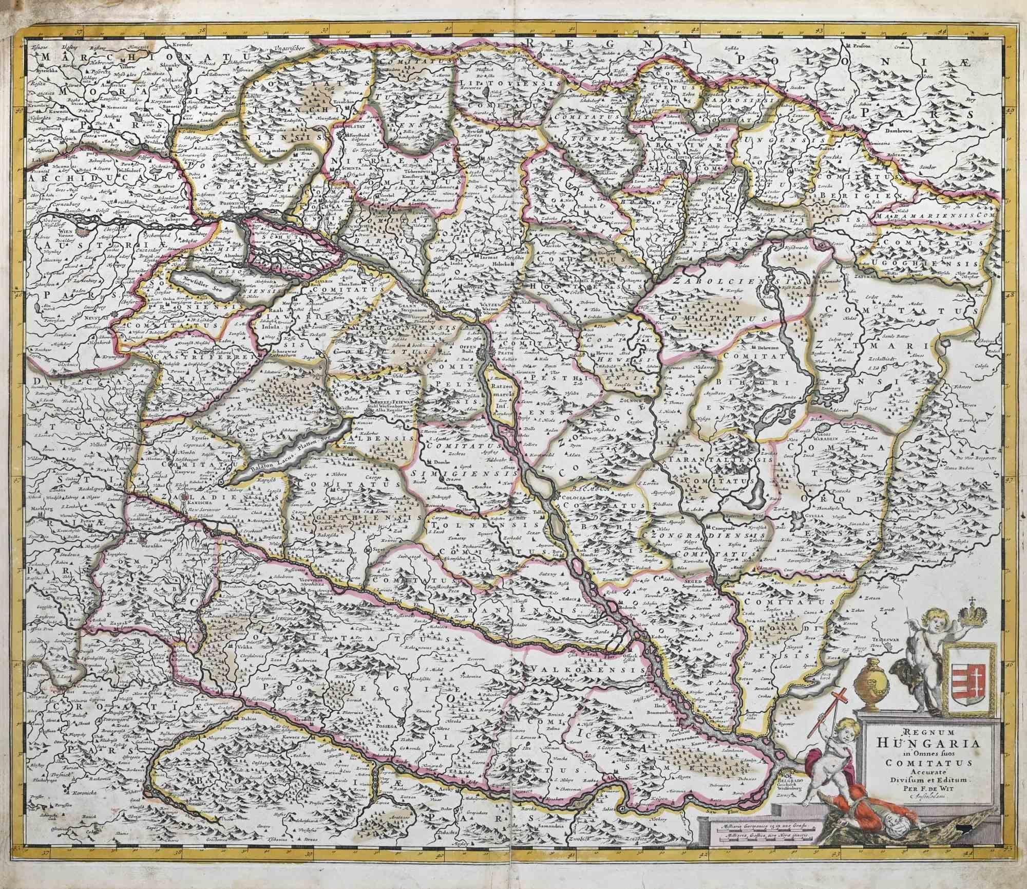
Regnum Hungariae - Etching by Frederick de Wit - 1680ca
By Frederick de Wit
Located in Roma, IT
This double-page etching with contemporary coloring, entitled Regnum Hungariae, was realized by the cartographer Frederick de Wit for the famous Atlas published in Amsterdam in ca. 1...
Category
1680s Modern Figurative Prints
Materials
Etching

You May Also Like
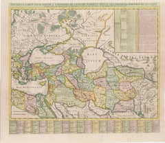
Persiae, Armeniae, Natoliae et Arabiae Descriptio per Frederick deWit 1666 map
Located in Paonia, CO
Map of Persiae, Armeniae, Natoliae et Arabiae Descriptio per F de Wit 1688 engraving from: Atlas Contractus Orbis Terrarum Praecipuas ac Novissimas Complectens Tabulas. Amsterdam, N. Visscher, 1656-77. (Koeman III, Vis5-8) This highly decorative map of the Middle East is by the Dutch engraver, publisher, and map seller...
Category
1660s Realist Landscape Prints
Materials
Engraving

Ottoman Empire Map 1719 – Europe Asia Africa, Jean Chiquet, Paris
Located in Langweer, NL
Title: Ottoman Empire Map 1719 – Europe Asia Africa, Jean Chiquet, Paris
Description:
Original early-18th-century engraved map titled Estats de l’Empire du Grand Seigneur, depicting the Ottoman Empire across three continents: Europe, Asia, and Africa. This example is clearly dated 1719 in the engraved cartouche and bears the publisher’s imprint Chez Jacq. Chiquet à Paris 1719.
The map presents the Ottoman Empire at an early Enlightenment moment, extending from Central and Southeastern Europe through Anatolia and the Levant, across Mesopotamia and Arabia, and into Egypt and the North African Barbary Coast. Political regions are defined by engraved boundaries and differentiated with original hand coloring, while coastlines, rivers, and seas are rendered with strong copper engraving typical of early 18th-century French map production.
French toponymy is dense and legible, with major cities and regions clearly identified, including Constantinople, Aleppo, Damascus, Baghdad, Cairo, Mecca, and Jerusalem. The Mediterranean, Black Sea, Red Sea, and Caspian Sea anchor the composition and emphasize the empire’s strategic maritime reach.
The decorative cartouche at upper right contains the full title and date, identifying the Ottoman ruler as “Grand Seigneur,” Sultan and Emperor of the Turks, ruling territories in Europe, Asia, and Africa. A lower table listing Ottoman rulers reinforces the political and didactic purpose of the map, which was intended both for geographic reference and informed private collecting.
Issued by Jean Chiquet, a Parisian map seller active in the early 18th century, this map reflects the commercial dissemination of authoritative geographic models during the reign of Louis XV. It combines political clarity with restrained decorative appeal, making it equally suitable for scholarly collections and interior display.
Condition report:
Copper engraving with original hand coloring. Age-related toning and light spotting consistent with an early 18th-century print. Minor edge wear and small handling marks, mainly in the margins. Plate mark visible. No major losses or repairs. Overall very good condition for a map dated 1719.
Framing tips:
Preserve the full margins and visible plate mark with a wide ivory or parchment-toned mat. A walnut, ebonized wood, or muted antique gold frame complements the period character. For a cleaner contemporary look, use a slim black frame with generous off-white matting.
SEO keyword block:
Ottoman Empire map 1719, antique Ottoman map, Jean Chiquet map, Middle East map 18th century, Holy Land map antique, Arabia map 1719, Turkey map...
Category
Antique Early 18th Century French Maps
Materials
Paper
18th-Century Map of the Eastern Roman Empire by Henri Chatelain, c. 1719
Located in Langweer, NL
Title: 18th-Century Map of the Eastern Roman Empire by Henri Chatelain, c. 1719
Description: This intricately detailed map, titled *Nouvelle Carte pour Servir à l'Histoire de l'Empi...
Category
Antique 1710s Maps
Materials
Paper
Finely Engraved Historical Map of Middle East and Asia, c.1745
Located in Langweer, NL
Description: Antique map titled'Theatrum Historicum pars Orientalis.'
Finely engraved historical map with a profusion of details. It shows the Middle East and Asia. Decorative ti...
Category
Antique 1740s Maps
Materials
Paper

Antique Map of Alexander the Great
s Empire
Campaigns, de Vaugondy, 1753
Located in Langweer, NL
Antique Map of Alexander the Great's Empire & Campaigns, de Vaugondy, 1753
This rare and elegantly engraved map, titled "Antiquor Imperiorum Tabula, in qua Prae Caeteris, Macedonicu...
Category
Antique Mid-18th Century European Maps
Materials
Paper
1742 Antique Map of the Persian Empire with Detailed Borders and Cartouche
Located in Langweer, NL
Title: 1742 Covens & Mortier Map of the Persian Empire by Guillaume De L'Isle
This remarkable 1742 map, "Carte de Perse," was originally designed by Guillaume De L'Isle, a preemin...
Category
Antique 1740s Dutch Maps
Materials
Paper
$1,542 Sale Price
20% Off
More Ways To Browse
Chagall Litho
Chagall Printemps
Chagall The Red Rider
Chagall Violin
Clerice Freres
Clint Eastwood Poster
Cowboy Etching
Cyrus Leroy Baldridge
Dali Alice Adventures
Dali Archangel
Dali Curie
Dali Demons
Dali Divine Comedy Woodcuts
Dali Immaculate Conception
Dali King David
Dali Litho
Dali Lithograph Cosmos
Dali Lobster