Items Similar to Map of Persia - Original Etching - Late 19th Century


Want more images or videos?
Request additional images or videos from the seller
1 of 2
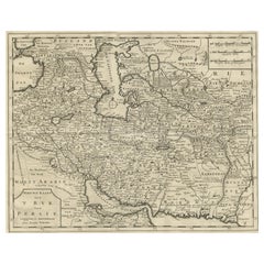
UnknownMap of Persia - Original Etching - Late 19th CenturyLate 19th Century
Late 19th Century
$285.56
£212.46
€240
CA$395.54
A$423.81
CHF 227.34
MX$5,020.09
NOK 2,867.82
SEK 2,623.61
DKK 1,828.69
About the Item
This Map of Persia is an etching realized by an anonymous artist.
The state of preservation of the artwork is good with some small diffused stains.
Sheet dimension: 25.5 x 44
At the top-right of the paper, the inscription “Longitudine del Meridiano dell' Isola del Ferro”, whilst at the bottom, just below the image, the inscription “Longitudine Est del Meridiano Parigi”. At the top right, the number of the sheet "Tav.XXIX is printed.
- Creation Year:Late 19th Century
- Dimensions:Height: 7.88 in (20 cm)Width: 9.65 in (24.5 cm)Depth: 0.04 in (1 mm)
- Medium:
- Movement Style:
- Period:
- Framing:Framing Options Available
- Condition:Insurance may be requested by customers as additional service, contact us for more information.
- Gallery Location:Roma, IT
- Reference Number:Seller: M-1133021stDibs: LU65037308852
About the Seller
4.9
Platinum Seller
Premium sellers with a 4.7+ rating and 24-hour response times
1stDibs seller since 2017
7,918 sales on 1stDibs
Typical response time: 1 hour
- ShippingRetrieving quote...Shipping from: Roma, Italy
- Return Policy
More From This Seller
View AllMap of Russia - Original Etching - Late 19th Century
Located in Roma, IT
This Map of Russia is an etching realized by an anonymous artist.
The state of preservation of the artwork is good with some small diffused stains.
Sheet dimension:27.5 x 44
At t...
Category
Late 19th Century Modern Figurative Prints
Materials
Etching
Map of Nubia and Abissinia - Original Etching by Antonio Zatta - 1784
Located in Roma, IT
This Map of Nubia and Abissinia is an etching realized by Antonio Zatta in Venice in 1784.
The state of preservation of the artwork is good expect for the worn paper with some littl...
Category
1770s Landscape Prints
Materials
Etching

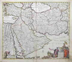
Nova Persiae, Armeniae, Natoliae et Ara.. - Etching by Frederick de Wit - 1680ca
By Frederick de Wit
Located in Roma, IT
This double-page etching with contemporary coloring, entitled Nova Persiae, Armeniae, Natoliae et Arabiae, was realized by the cartographer Frederick de Wit for the famous Atlas publ...
Category
1680s Modern Figurative Prints
Materials
Etching
Map of the World - Original Etching - 1820
Located in Roma, IT
Map of the World is an Original Etching realized by an unknown artist of 19th century in 1820.
Very good condition on two sheets of white paper joine...
Category
1820s Modern Figurative Prints
Materials
Etching

Map of Campaign of 1814 - Etching by Pierre François Tardieu - 1837
Located in Roma, IT
Map of Campaign of 1814 is an Etching realized by Pierre François Tardieu in 1837.
Good conditions.
The artwork is realized in a well-balanced composition. the artwork and belongs ...
Category
1830s Modern Figurative Prints
Materials
Lithograph

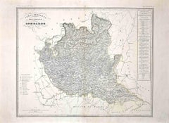
Map of Lombardy - Original Etching - 19th Century
Located in Roma, IT
The Map of Lombardy is an original etching realized by an anonymous artist.
Fair conditions, the folding line of the middle is repaired.
The artwork represents the map of Lombardo....
Category
19th Century Modern Figurative Prints
Materials
Etching
You May Also Like
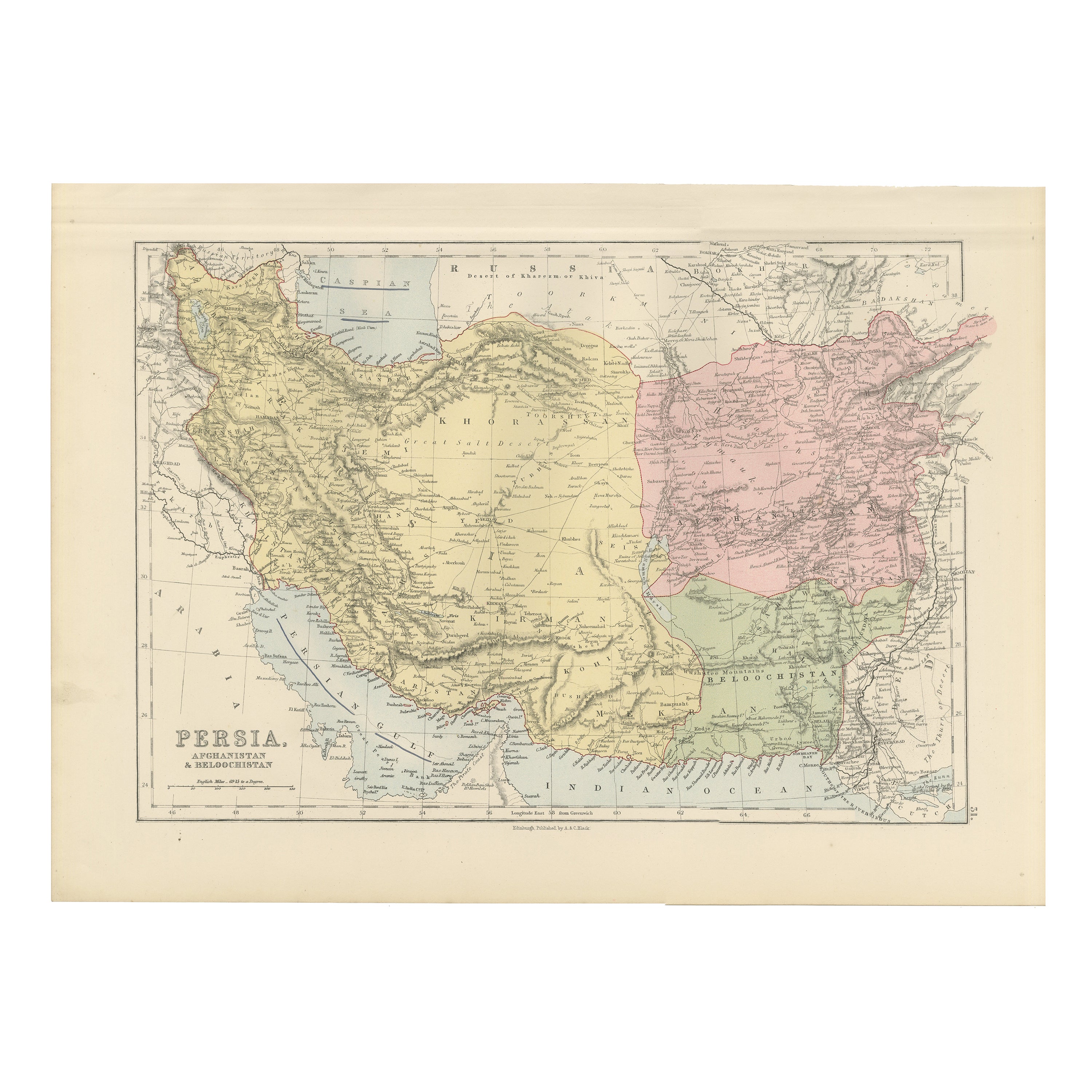
Antique Map of Persia, Afghanistan and Beloochistan – Black’s Atlas, 1884
Located in Langweer, NL
Here is a catalogue entry in your preferred format for the Persia map you uploaded, in plain text and without using *:
---
Title: Antique Map of Persia, Afghanistan and Beloochista...
Category
Antique 1880s Scottish Maps
Materials
Paper

Antique Map of Persia and Afghanistan by Johnston
1909
Located in Langweer, NL
Antique map titled 'Persia and Afghanistan'. Original antique map of Persia and Afghanistan. This map originates from the ‘Royal Atlas o...
Category
Early 20th Century Maps
Materials
Paper

$237 Sale Price
20% Off
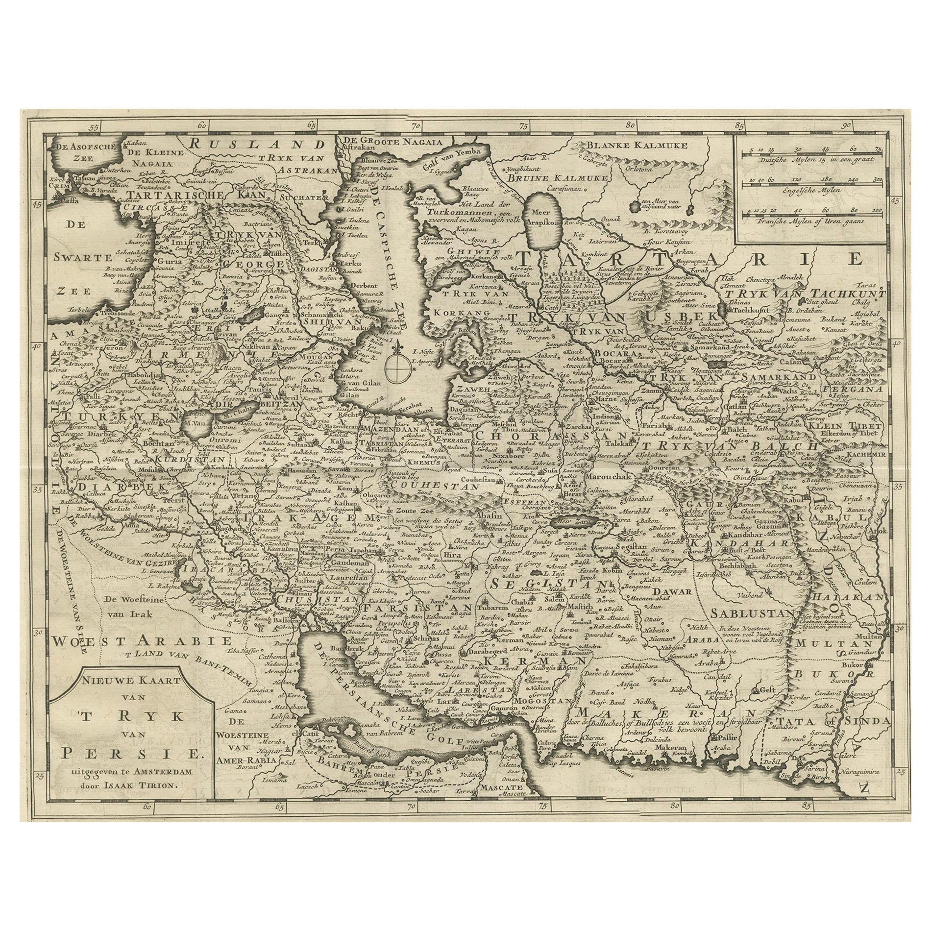
Map of Persia, the Caspian
India – Isaak Tirion, c.1730
Located in Langweer, NL
Map of Persia and Surrounding Regions – “Nieuwe Kaart van 't Ryck van Persie” by Isaak Tirion, Amsterdam, c. 1730
This finely detailed copperplate map titled “Nieuwe Kaart van 't Ry...
Category
Antique Mid-18th Century Dutch Maps
Materials
Paper
Antique Map of Persia and Afghanistan by Johnston, 1882
Located in Langweer, NL
Antique map titled 'Persia and Afghanistan'.
Old map of Persia and Afghanistan. This map originates from 'The Royal Atlas of Modern Geography, Exhibiting, in a Series of Entirely O...
Category
Antique 19th Century Maps
Materials
Paper

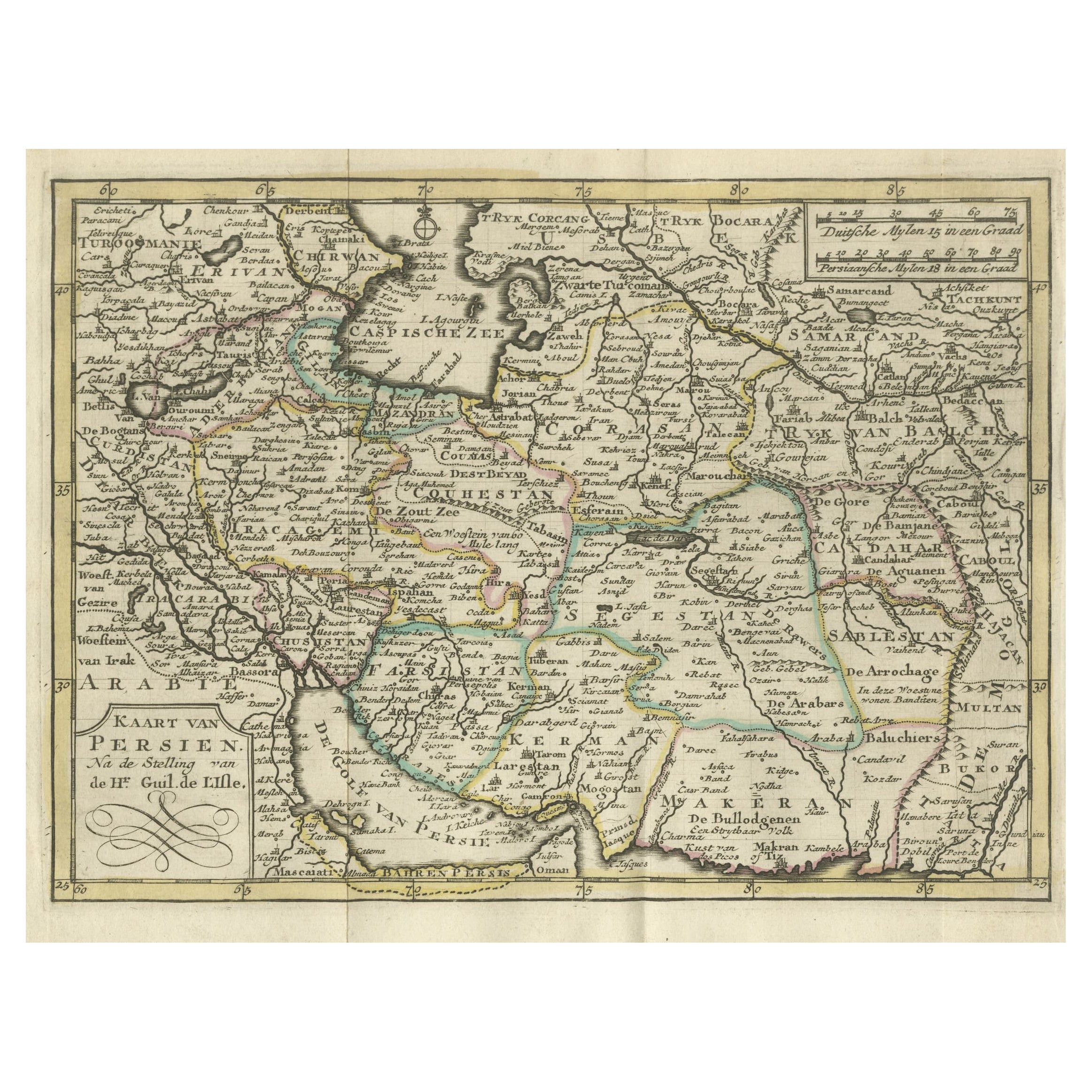
Authentic Old Map of Persia with Original Border Coloring, 1745
Located in Langweer, NL
Title: "Kaartje van Persien na de stelling van den Heer Guillaume de L'Isle"
Translates to "Map of Persia based on the work of Mr. Guillaume de L'Isle." Guillaume de L'Isle was a p...
Category
Antique 1740s Maps
Materials
Paper

Persia Unveiled: Antique Map of Iran, Afghanistan, and Beyond, 1852
Located in Langweer, NL
The antique map titled 'Royaumes de Perse Herat & Kaboul' is an attractive map of Persia. Here are the key details and features of the map:
1. **Geographic Coverage**:
- The map ...
Category
Antique Mid-19th Century French Maps
Materials
Paper

$152 Sale Price
20% Off
More Ways To Browse
Dali Illustrates Casanova
Dali Man Of La Mancha
Dali Othello
Dali Pig And Pepper
Dali Purgatory Signed
Dali Saba
Dali Signed Ecstatic
Dali Skeleton
Dali Spinning Man
Dali The Annunciation
Dali Thus Was Earth Created
Dame Laura Knight On Sale
Danos Flower Shop
Daumier Actualites
David Ham
David Schluss Serigraph
David Shrigley You Are Special
Degas Poster