Items Similar to Map of Nubia and Abissinia - Original Etching by Antonio Zatta - 1784


Want more images or videos?
Request additional images or videos from the seller
1 of 5
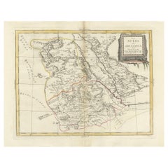
Antonio ZattaMap of Nubia and Abissinia - Original Etching by Antonio Zatta - 17841784
1784
$773.38
£575.41
€650
CA$1,071.24
A$1,147.82
CHF 615.72
MX$13,596.07
NOK 7,767.01
SEK 7,105.62
DKK 4,952.69
About the Item
This Map of Nubia and Abissinia is an etching realized by Antonio Zatta in Venice in 1784.
The state of preservation of the artwork is good expect for the worn paper with some little stains.
Mounted on a cardboard passpartout 50x60 cm.
On the upper right margin of the map the title "La Nubia ed Abissinia" followed by Antonio Zatta, Venezia 1784.
- Creator:Antonio Zatta (1757 - 1797)
- Creation Year:1784
- Dimensions:Height: 12.84 in (32.6 cm)Width: 16.54 in (42 cm)Depth: 0.04 in (1 mm)
- Medium:
- Period:1770-1779
- Framing:Framing Options Available
- Condition:Insurance may be requested by customers as additional service, contact us for more information.
- Gallery Location:Roma, IT
- Reference Number:Seller: M-1139561stDibs: LU65037433152
About the Seller
4.9
Platinum Seller
Premium sellers with a 4.7+ rating and 24-hour response times
1stDibs seller since 2017
7,918 sales on 1stDibs
Typical response time: 1 hour
- ShippingRetrieving quote...Shipping from: Roma, Italy
- Return Policy
More From This Seller
View AllMap of Greece - Etching by Antonio Zatta - 18th Century
Located in Roma, IT
This Map of Greece is an etching realized by Antonio Zatta, Cartographer, publisher and typographer.
The state of preservation of the artwork is good except for the worn paper and t...
Category
1780s Figurative Prints
Materials
Etching

Map of Ancient Greece - Original Etching by Antonio Zatta - 1785
Located in Roma, IT
This Map of ancient Greek is an etching realized by Antonio Zatta in Venice in 1785.
The state of preservation of the artwork is good expect for the worn paper.
Mounted on a cardbo...
Category
1770s Landscape Prints
Materials
Etching

Map of Africa - Original Etching by C. Brue - 1820
Located in Roma, IT
Map of Africa is an original etching realized by C.Brue in 1820.
The print comes from the Series "Atlas Universal" PL. 31.
The state of preservation of the artwork is good except f...
Category
1820s Modern Figurative Prints
Materials
Etching

Ancient Map of Senegal - Original Etching - 19th Century
Located in Roma, IT
Map of Senegal is an original etching realized by an anonymous engraver of the 19th Century.
Printed in series of "France Pittoresque" at the top center.
The state of preservation ...
Category
19th Century Figurative Prints
Materials
Etching

Map of Campaign of 1814 - Etching by Pierre François Tardieu - 1837
Located in Roma, IT
Map of Campaign of 1814 is an Etching realized by Pierre François Tardieu in 1837.
Good conditions.
The artwork is realized in a well-balanced composition. the artwork and belongs ...
Category
1830s Modern Figurative Prints
Materials
Lithograph

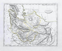
Map of Persia - Original Etching - Late 19th Century
Located in Roma, IT
This Map of Persia is an etching realized by an anonymous artist.
The state of preservation of the artwork is good with some small diffused stains.
Sheet dimension: 25.5 x 44
At t...
Category
Late 19th Century Modern Figurative Prints
Materials
Etching
You May Also Like
Nubia and Abyssinia – Venetian Map of Northeast Africa, Zatta, 1784
Located in Langweer, NL
Nubia and Abyssinia – Venetian Map of Northeast Africa, Zatta, 1784
This detailed late-18th-century map depicts Nubia and Abyssinia, covering large parts of present-day Sudan, Ethiopia, Eritrea, and the Horn of Africa. The map is titled “La Nubia ed Abissinia” and was published in Venice in 1784 by Antonio Zatta, one of the most important Italian map publishers of the period. It forms part of Zatta’s monumental Atlante Novissimo, produced with the privilege of the Venetian Senate.
The map presents the Nile basin in exceptional detail, tracing the river from its upper reaches through Nubia toward Egypt, while also mapping the Red Sea coast, inland mountain ranges, deserts, and regional kingdoms. Political and regional boundaries are outlined in contemporary hand color, distinguishing Nubia, Abyssinia, and neighboring territories. Numerous towns, tribal regions, rivers, and topographical features are carefully named, reflecting the synthesis of classical sources, Jesuit reports, and more recent travel accounts available to European geographers in the late Enlightenment period.
Zatta’s cartography represents the Italian continuation of the scientific mapping tradition pioneered by Delisle and d’Anville, emphasizing clarity, proportional accuracy, and critical compilation of sources. While interior Africa remained imperfectly known, this map shows a marked departure from earlier speculative geography, replacing legend with measured structure and comparative reasoning.
The decorative title cartouche, engraved in a restrained architectural style, anchors the upper right and reflects the sober elegance characteristic of Venetian Enlightenment cartography. Latitude and longitude lines, clean engraving, and balanced composition give the map strong visual presence without excess ornamentation.
This map is particularly appealing to collectors of African cartography, Nile exploration history, Ethiopian history, and Enlightenment-era geography. It also serves as an excellent intellectual counterpart to earlier French coastal and regional charts of Africa, illustrating the progression of European geographic knowledge during the 18th century.
Condition report
Good condition overall. Central vertical fold as issued. Light age toning and some mild discoloration, more noticeable along the fold. Minor scattered spots and faint handling marks. Original outline hand color. Plate mark visible. Margins intact.
Framing tips
A wide off-white or light sand-colored mat is recommended to balance the dense interior detail and preserve visual calm. A medium to dark wood frame enhances the engraved line work and complements the restrained hand coloring. Particularly effective as a scholarly centerpiece or paired with Indian Ocean or Nile-related maps.
Technique: Copper engraving with contemporary outline hand color
Maker: Antonio Zatta, Venice, 1784
Keywords: Nubia map, Abyssinia map, Ethiopia antique...
Category
Antique 1780s Italian Maps
Materials
Paper
Antique Map of The Nile, Egypt and the Red Sea by Bachiene, 1765
Located in Langweer, NL
Antique map titled 'De XIde Landkaart verbeeldende Egypte en de Woestyne der Schelf-Zee (..).' Map of Biblical Egypt and the Red Sea. With title cartouche, compass rose and scale. Th...
Category
Antique 18th Century Maps
Materials
Paper

Antique Map of Arabia, Red Sea
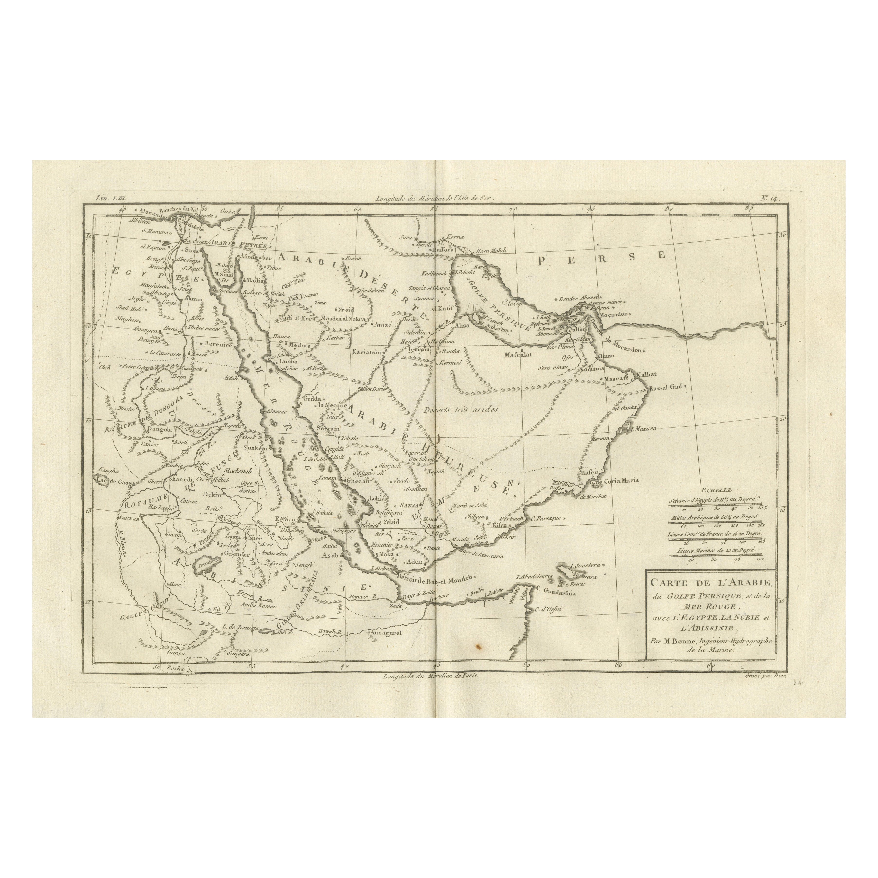
Persian Gulf by Rigobert Bonne, 1780
Located in Langweer, NL
Arabia, Red Sea & Persian Gulf – Antique Map, Bonne c1780
Description:
This striking map covers the Arabian Peninsula, the Red Sea, Persian Gulf, Egypt, and parts of East Africa. Ri...
Category
Antique Late 18th Century French Maps
Materials
Paper
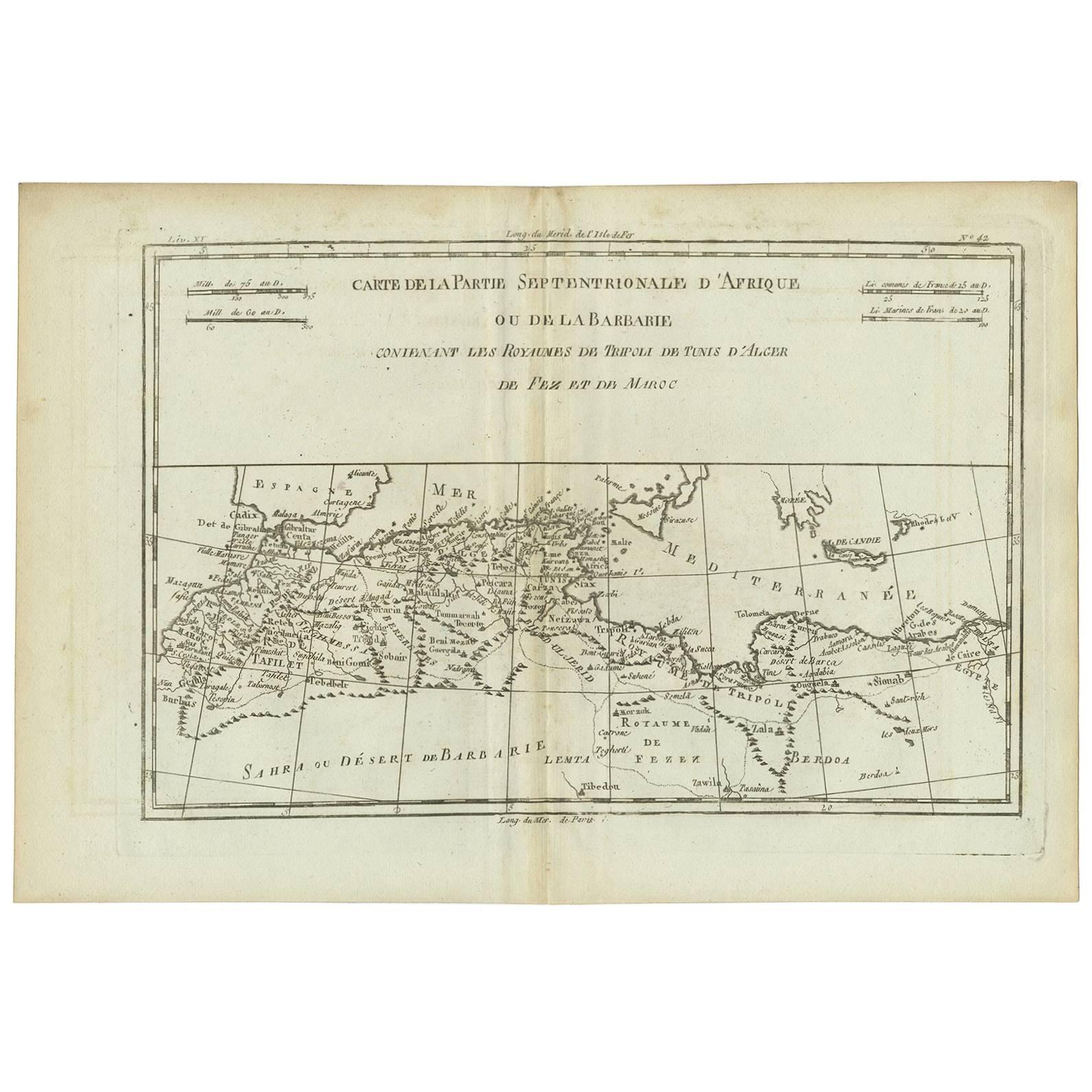
Antique Map of Northern Africa "Barbary Coast" by R. Bonne, circa 1780
Located in Langweer, NL
A fine example of Rigobert Bonne and Guilleme Raynal’s 1780 map of northwestern Africa or the Barbary Coast. Includes the modern day countries of Morocco, Algeria, Tunisia, Libya, and parts of adjacent Spain, Italy and Greece. This map was made in response to European interest in the region due to coastal attacks and incursions by the Barbary Pirates...
Category
Antique Late 18th Century French Maps
Materials
Paper
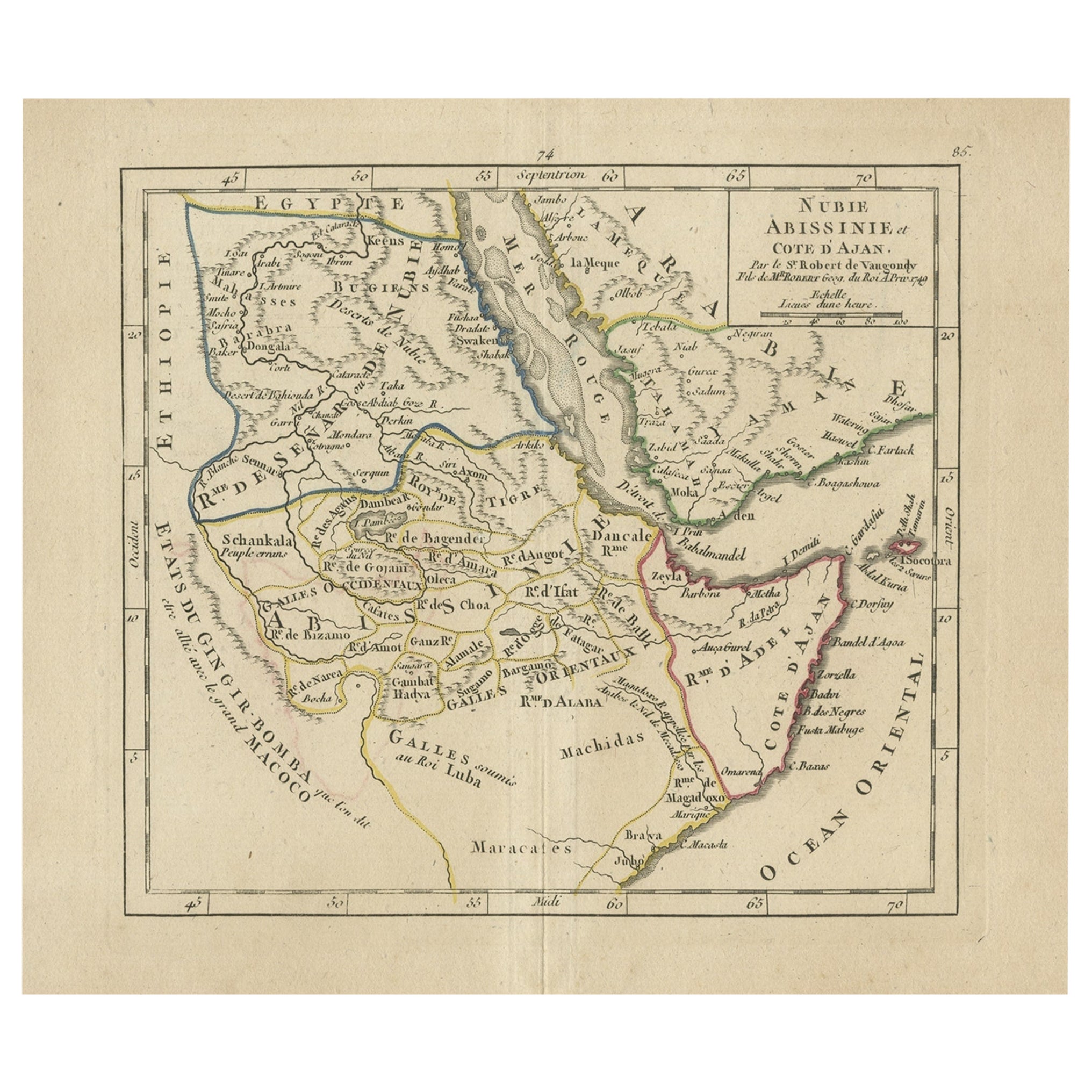
Antique Map of Abyssinia, Sudan and the Red Sea, Arabia and Egypt South, 1749
Located in Langweer, NL
Antique map titled 'Nubie, Abissinie et Cote d'Ajan'. Map of Abyssinia, Sudan and the Red Sea by Robert Vaugondy. Covers from Arabia and Egypt south to Mogadishu and includes parts o...
Category
Antique 18th Century Maps
Materials
Paper
Antique Map of the Arabian Peninsula by Franceschini,
1739
Located in Langweer, NL
Antique map titled 'Conventus et Residentiae'. Rare map of the Arabian Peninsula. This map originates from 'Provinciarum et Conventum Fratrum Discalc...
Category
Antique Mid-18th Century Maps
Materials
Paper

$535 Sale Price
40% Off
More Ways To Browse
Marcel Gimond
Outsider Art Cat
Pablo Picasso Pichet
Pepsi Cola Vintage
Queen Mary Ship
Raoul Dufy Watercolour
San Leandro
Sculpture Abstract Body
Sculpture Clay Birds
Sergii Shaulis
Southwest Sculpture
Steven Tyler
Stirling Moss
Suarez Frimkess
Victory Samothrace
Vintage Book Cover Posters
Vintage Swim
Woman Undressing