Items Similar to England Map of the County of Southampton from an Actual Survey


Want more images or videos?
Request additional images or videos from the seller
1 of 5
Christopher
John GreenwoodEngland Map of the County of Southampton from an Actual Survey1817-1832
1817-1832
$550
£417.68
€479.83
CA$775.37
A$824.38
CHF 445.80
MX$9,806.24
NOK 5,584.27
SEK 5,100.10
DKK 3,584.52
About the Item
Cartographers Christopher (1786-1855) and John (1791-1867) Greenwood were surveyors from Yorkshire, who undertook an ambitious project to produce a series of large-scale maps of the counties of England, Wales and Scotland.The maps represent a remarkable and impressive surveying achievement forming an important record of the counties depicted.
In the years 1817-1832 the Greenwood brothers published the Atlas of The Counties of England from an Actual Survey. This Atlas was finely drafted and engraved and decorated with large vignettes of prominent buildings of the county. This map of Southampton County is beautifully hand colored and is in very good condition. There is a vignette of Winchester Cathedral in the lower right corner.
- Creator:Christopher John Greenwood (1786 - 1867)
- Creation Year:1817-1832
- Dimensions:Height: 25.25 in (64.14 cm)Width: 31 in (78.74 cm)
- Medium:
- Period:
- Condition:
- Gallery Location:Paonia, CO
- Reference Number:1stDibs: LU78033567581
About the Seller
4.9
Vetted Professional Seller
Every seller passes strict standards for authenticity and reliability
Established in 1978
1stDibs seller since 2017
134 sales on 1stDibs
Typical response time: 1 hour
- ShippingRetrieving quote...Shipping from: Paonia, CO
- Return Policy
More From This Seller
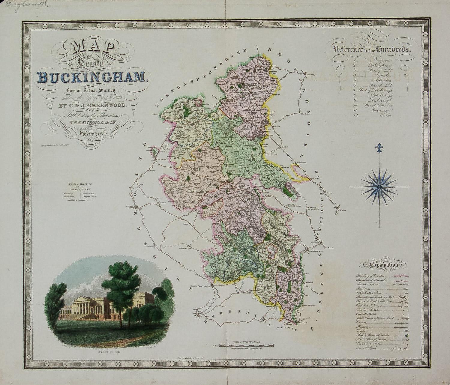
View AllMap of the County of Buckingham From an Actual Survey
Located in Paonia, CO
Cartographers Christopher (1786-1855) and John (1791-1867) Greenwood were surveyors from Yorkshire, who undertook an ambitious project to produce a series of large-scale maps of the counties of England, Wales and Scotland.The maps represent a remarkable and impressive surveying achievement forming an important record of the counties depicted.
In the years 1817-1832 the Greenwood brothers published the Atlas of The Counties of England from an Actual Survey. This Atlas was finely drafted and engraved and decorated with large vignettes of prominent buildings of the county. This map of Buckingham County is beautifully hand colored and is in very good condition. There is a vignette of Stowe House...
Category
19th Century Other Art Style More Prints
Materials
Engraving

Antique 1765 Wine Country Folding Map of France, Bordeau etc.
Located in Paonia, CO
Route du Carosse de Bordeaux, part de Paris tous les Mardis a 11 matin. a et pafse 1765 is a comprehensive map with two routes through the wine country of France starting in Paris going south...
Category
1760s Other Art Style Landscape Prints
Materials
Etching

Carte Particuliere Des Coste De Bretagne qui Comprend Morlaix
By Pierre Mortier
Located in Paonia, CO
Carte Particuliere Des Costes De Bretagne qui Comprend Morlaix, Saint Paul de Leon, les Sept Isles, et L’Isle. Faite par ordre Exprez Du Roy de France is from the collection of ch...
Category
1690s Landscape Prints
Materials
Engraving

Map of Tabula Geographica Territorium Civitatis Svevo=Hallensis by Homann 1762
By Homann Heirs
Located in Paonia, CO
Map of Tabula Geographica sistens Territorium Liberae Sacri Romani Imperi Civitatis Svevo=Hallensis in suas Praefecturas divisum unacum finitimis Regionibus delineata a Mattheo ...
Category
1760s Other Art Style More Prints
Materials
Engraving
Carte Particular Des Costes De Bretagne Depuis le Cap de Frehel, Jusques a Perros
By Pierre Mortier
Located in Paonia, CO
Carte Particulaire Des Costes De Bretagne Depuis Le Cap de Frehel, Jusques a Perros, & L’Isle Tome. This large sea scale chart shows part of the northwestern co...
Category
1690s Landscape Prints
Materials
Engraving
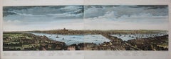
A View of London as it was in the Year 1647 pub. by Boydell 1756
Located in Paonia, CO
A View of London as it was in the Year 1647 is a hand colored copper engraving published by the well known British publisher and engraver John Boydell (1720-1804) and engraved by R.Benning sold at Cheapside London 1756. Panoramic view on two sheets conjoined as issued linen mounted. Lettered with title in French and English along the base of the image including a numbered key to the structures. In very good condition except for one 1/8 inch tear in the sky to the left of the middle seam that is barely noticeable. This is a large very detailed panorama of London...
Category
1750s Other Art Style Landscape Prints
Materials
Etching
You May Also Like
Large Antique County Map of Essex, England
Located in Langweer, NL
Antique map titled 'A Map of Essex from the best Authorities'. Original old county map of Essex, England. Engraved by John Cary. Originates from 'New Brit...
Category
Antique Early 19th Century Maps
Materials
Paper

$295 Sale Price
20% Off
Antique Map of Southern England
Wales, 1903, with Coastal Details and Railways
Located in Langweer, NL
Title: Antique Map of Southern England and Wales, 1903, with Coastal Details and Railways
Description:
This detailed antique map, titled "England and Wales (Southern Sheet I)," was ...
Category
Early 20th Century Maps
Materials
Paper
Antique English Map – Southern England
Wales, Johnston’s Royal Atlas, 1865
Located in Langweer, NL
Antique Map of England & Wales (Southern Sheet) – Johnston’s Royal Atlas, 1865
This finely engraved antique map, titled *England and Wales (Southern Sheet)*, was published in 1865 i...
Category
Antique Mid-19th Century Scottish Maps
Materials
Paper

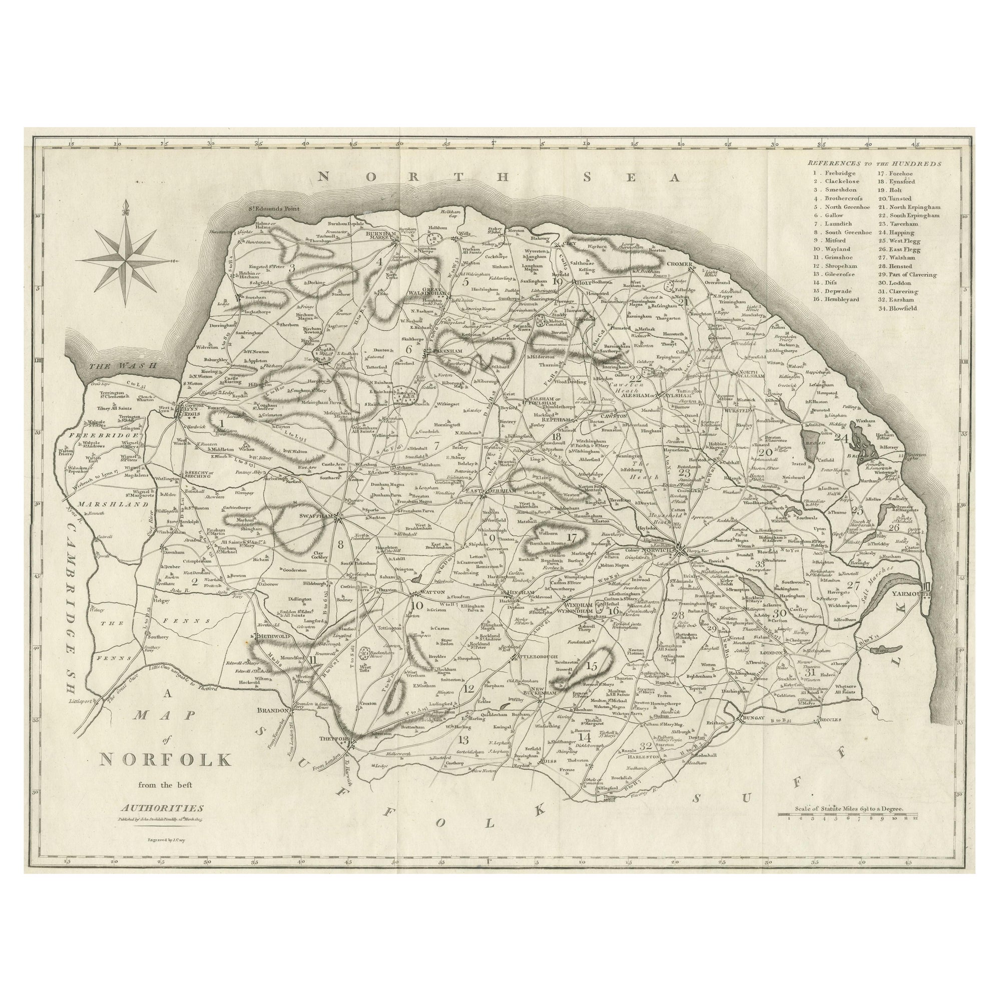
Large Antique County Map of Norfolk, England
Located in Langweer, NL
Antique map titled 'A Map of Norfolk from the best Authorities'. Original old county map of Norfolk, England. Engraved by John Cary. Originates from 'N...
Category
Antique Early 19th Century Maps
Materials
Paper
$267 Sale Price
20% Off
Antique Map of England and Wales by Johnston, 1882
Located in Langweer, NL
Antique map titled 'England and Wales'. Old map of England and Wales, with an inset map of Scilly Islands. This map originates from 'The Royal Atlas of Modern Geography, Exhibiting, ...
Category
Antique 19th Century Maps
Materials
Paper

Map of Essex by Emanuel Bowen
Located in Cheshire, GB
Map of part of Essex and part of Kent, hand-coloured. Encased in an ebonized and gilded frame.
Dimensions
Height 25.5 Inches
Length 32.5 Inches
width 1 Inches.
Category
Antique Late 19th Century British Maps
Materials
Paper

$986 Sale Price
50% Off