Items Similar to West Coast of Africa; Guinea
Sierra Leone: Bellin 18th Century Map

Want more images or videos?
Request additional images or videos from the seller
1 of 10
Jacques Nicolas BellinWest Coast of Africa; Guinea
Sierra Leone: Bellin 18th Century Map1780
1780
$575
£436.66
€501.64
CA$810.61
A$861.85
CHF 466.06
MX$10,251.98
NOK 5,838.10
SEK 5,331.92
DKK 3,747.45
About the Item
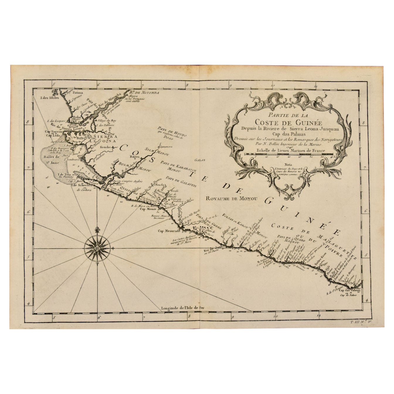
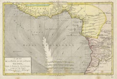
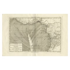
This is a Jacques Bellin copper-plate map entitled "Partie de la Coste de Guinee Dupuis la Riviere de Sierra Leona Jusquau Cap das Palmas", depicting the coast of Guinea and Sierra Leone in West Africa, published in Paris in 1780 in Antoine-Francois Prevost's "Histoire Générale des Voyages, ou nouvelle collection de toutes les relations de voyages par mer et par terre, qui ont été publiées jusqu'à present dans les différentes langues de toutes les nations connues".
Prevost's "L'Histoire Generale des Voyages" was an expansive work that mapped China, the East Indies, Asia, the Americas, early voyages to Australia, New Guinea, the Palau Islands, Africa, and voyages in the Pacific including those of Magellan, Schouten, and Le Maire, Drake, Sarmiento, Cavendish, Spilbergen, Narborough, Rogers, Cowley, Frazier, and Anson. The work included accounts of the Dutch and French voyages to the East Indies, voyages to China, and the British East India Company's voyages to India and Ceylon. The publication was published before the three voyages of discovery by Captain James Cook later in the 18th century.
The map is printed on laid, chain-linked, watermarked paper. There are wide margins all around and a central vertical fold, as issued. There is mild spotting in the upper margin and to a lesser extent in the right margin, but the map is otherwise in excellent condition.
Two other Bellin maps are available on 1stDibs, including an unframed map of the island of St. Christophe, now known as St. Kitts, "Carte De De l'Isle St. Christophe", Reference #: LU117328585712 and a map of St. Lucie framed in lucite, Reference: LU117324370471. These maps would make a striking display grouping. A discount is available for the purchase of two or more maps.
The map was prepared by Jacques Nicolas Bellin (1703–1772), who was one of the most important cartographers of the 18th century. He served for a number of years as map and chart maker, as well hydrographer to the King of France.
- Creator:Jacques Nicolas Bellin (1703 - 1772)
- Creation Year:1780
- Dimensions:Height: 10 in (25.4 cm)Width: 14.25 in (36.2 cm)
- Medium:
- Movement Style:
- Period:1740-1749
- Framing:Framing Options Available
- Condition:
- Gallery Location:Alamo, CA
- Reference Number:Seller: # 46171stDibs: LU117328585822
About the Seller
5.0
Platinum Seller
Premium sellers with a 4.7+ rating and 24-hour response times
Established in 2011
1stDibs seller since 2019
306 sales on 1stDibs
Typical response time: 1 hour
- ShippingRetrieving quote...Shipping from: Alamo, CA
- Return Policy
More From This Seller
View AllWest Africa: A 17th Century Hand-Colored Map by Mercator/Hondius
By Gerard Mercator
Located in Alamo, CA
A 17th century hand-colored map entitled "Guineae Nova Descriptio" by Gerard Mercator and Jodocus Hondius, published in their 'Atlas Minor' in Amsterdam in 1635. It is focused on the...
Category
1630s Landscape Prints
Materials
Engraving

West Africa: 18th Century Hand-colored Homann Map Entitled "Guinea Propria"
By Johann Baptist Homann
Located in Alamo, CA
This is a scarce richly hand colored copper plate engraved map of Africa entitled "Guinea Propria, nec non Nigritiae vel Terrae Nigrorum Maxima Pars" by Johann Baptist Homann (1664-1...
Category
1740s Other Art Style Prints and Multiples
Materials
Engraving

Africa: A Large 17th Century Hand-colored Map By Sanson and Jaillot
By Nicholas Sanson d
Abbeville
Located in Alamo, CA
This large original hand-colored copperplate engraved map of Africa entitled "L'Afrique divisee suivant l'estendue de ses principales parties ou sont distingues les uns des autres, L...
Category
1690s Landscape Prints
Materials
Engraving

"Africa Vetus": A 17th Century Hand-colored Map By Sanson
By Nicholas Sanson d
Abbeville
Located in Alamo, CA
This original hand-colored copperplate engraved map of Africa entitled "Africa Vetus, Nicolai Sanson Christianiss Galliar Regis Geographi" was originally created by Nicholas Sanson d...
Category
1690s Landscape Prints
Materials
Engraving

California: 18th Century Hand-colored Map by de Vaugondy
By Didier Robert de Vaugondy
Located in Alamo, CA
This is an 18th century hand-colored map of the western portions of North America entitled "Carte de la Californie et des Pays Nord-Ouest separés de l'Asie par le détroit d'Anian, ex...
Category
1770s Landscape Prints
Materials
Engraving

Rugen Island, Germany: An Early 17th Century Map by Mercator and Hondius
By Gerard Mercator
Located in Alamo, CA
This is an early 17th century map entitled "Nova Famigerabilis Insulae Ac Ducatus Rugiae Desciptio" (Map of Rugen Island, Germany) by Gerard Mercator and Henricus and Joducus Hondiu...
Category
Early 17th Century Old Masters Landscape Prints
Materials
Engraving

You May Also Like
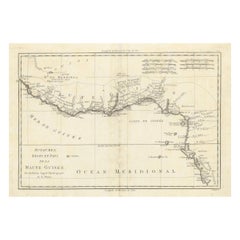
West Coast of Africa, Guinea
Sierra Leone: An 18th Century Map by Bellin
By Jacques-Nicolas Bellin
Located in Alamo, CA
Jacques Bellin's copper-plate map entitled "Partie de la Coste de Guinee Dupuis la Riviere de Sierra Leona Jusquau Cap das Palmas", depicting the coast of Guinea and Sierra Leone in ...
Category
Antique Mid-18th Century French Maps
Materials
Paper

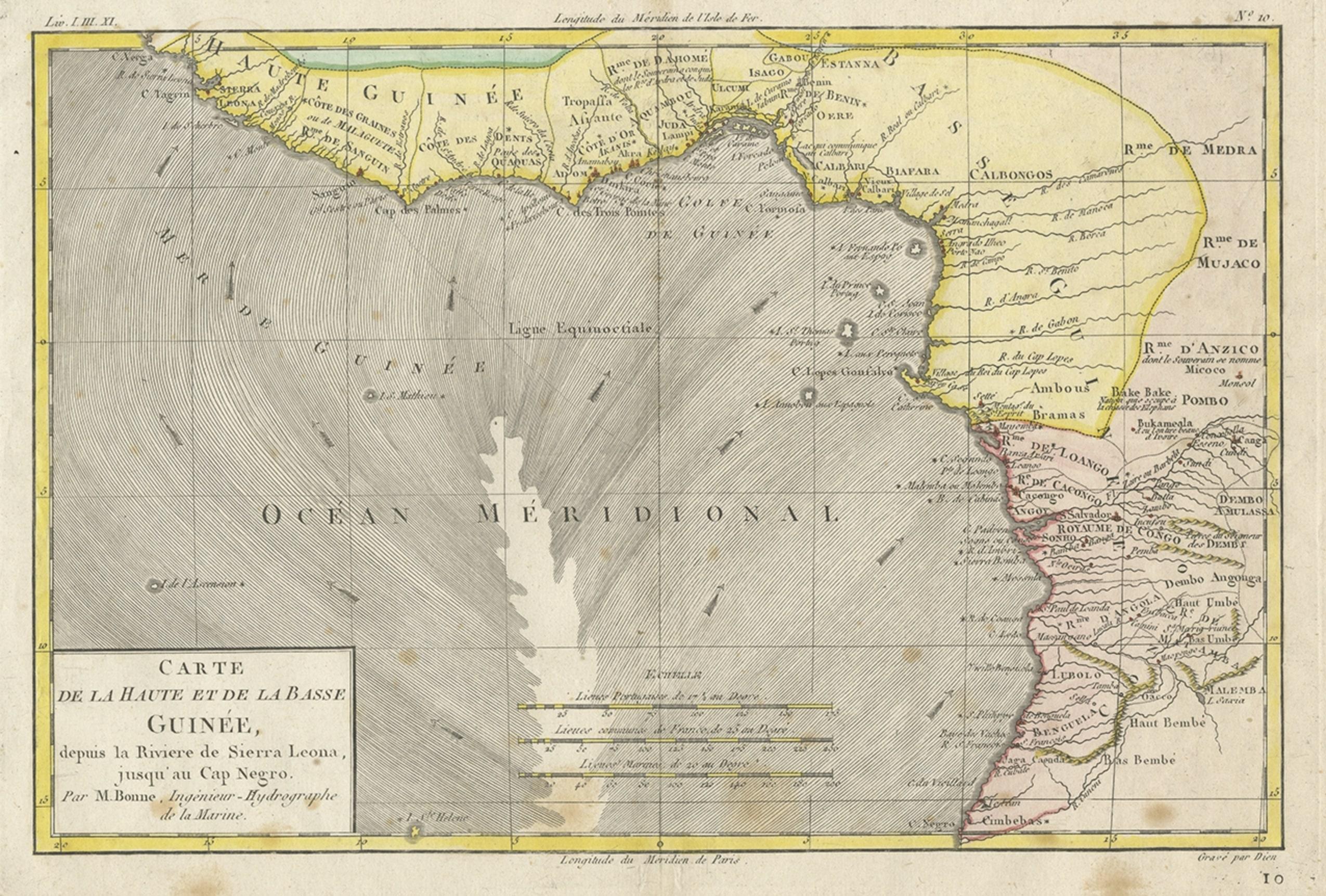
Antique Map of the Coast of Guinea, Africa, 1820
Located in Langweer, NL
Antique map Africa titled 'Carte de la Haute et de la Basse Guinée'. Map of the Coast of Guinea, Africa. Represents modern day Liberia, Ivory Coast, Ghana, Nigeria, Cameroon, Gabon, Congo, and Equatorial Guinea...
Category
Antique 19th Century Maps
Materials
Paper
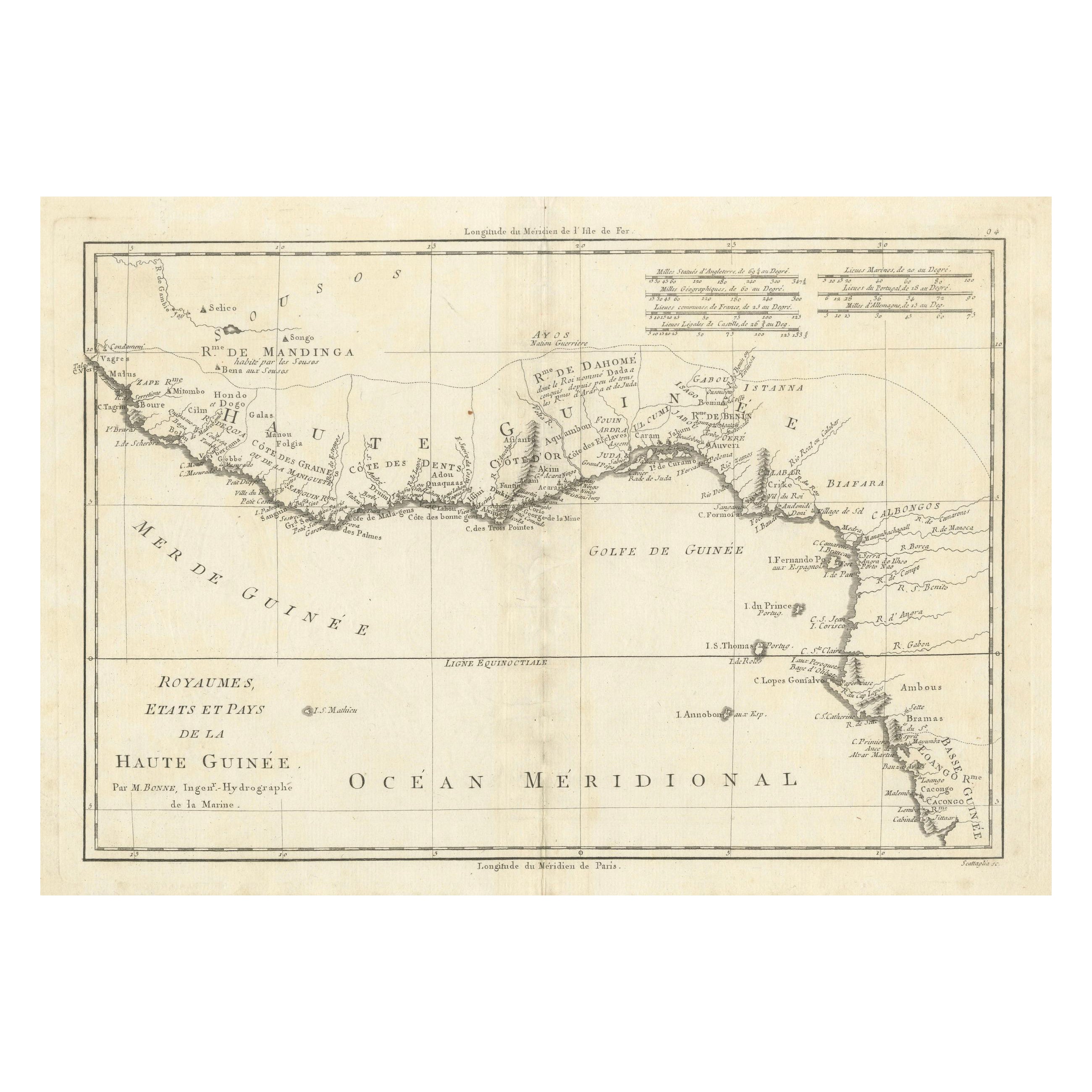
18th Century Map of Upper Guinea: Kingdoms and Coastal Regions of West Africa
Located in Langweer, NL
This is an antique map depicting the coastal regions of West Africa, specifically the Gulf of Guinea and surrounding areas, including parts of what is now Senegal, Guinea, Sierra Leo...
Category
Antique 1780s Maps
Materials
Paper
$228 Sale Price
20% Off
Antique Map of the Coast of Guinea, Africa, c.1780
Located in Langweer, NL
Antique map Africa titled 'Carte de la Haute et de la Basse Guinée'. Map of the Coast of Guinea, Africa. Represents modern day Liberia, Ivory Coast, Ghana, Nigeria, Cameroon, Gabon, Congo, and Equatorial Guinea...
Category
Antique 18th Century Maps
Materials
Paper

Upper
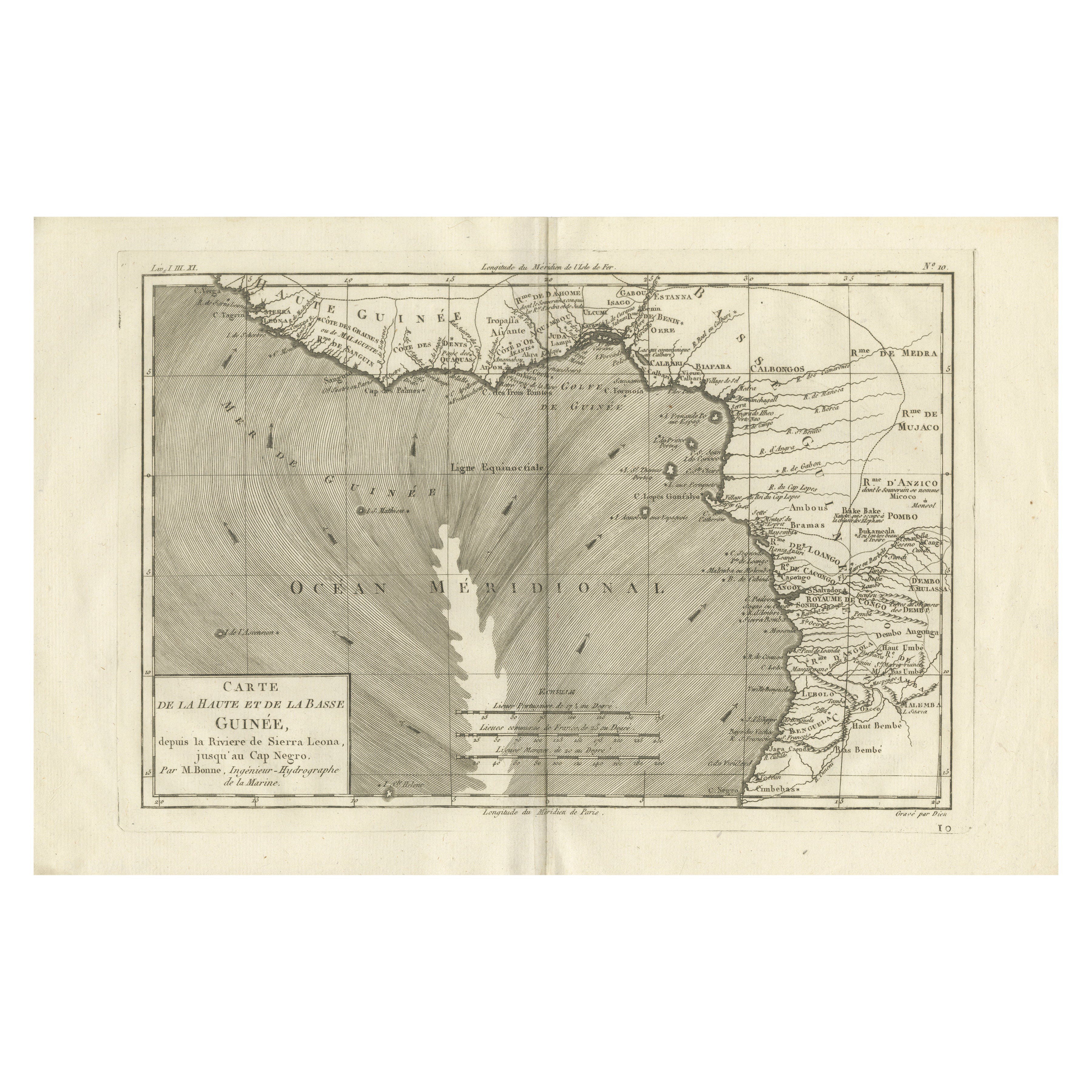
Lower Guinea Coast Map – West Africa by Bonne c.1780
Located in Langweer, NL
Upper & Lower Guinea Coast Map – West Africa by Bonne c.1780
DESCRIPTION
This detailed coastal map covers Upper and Lower Guinea, extending from Sierra Leone toward Central Africa. ...
Category
Antique Late 18th Century French Maps
Materials
Paper
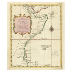
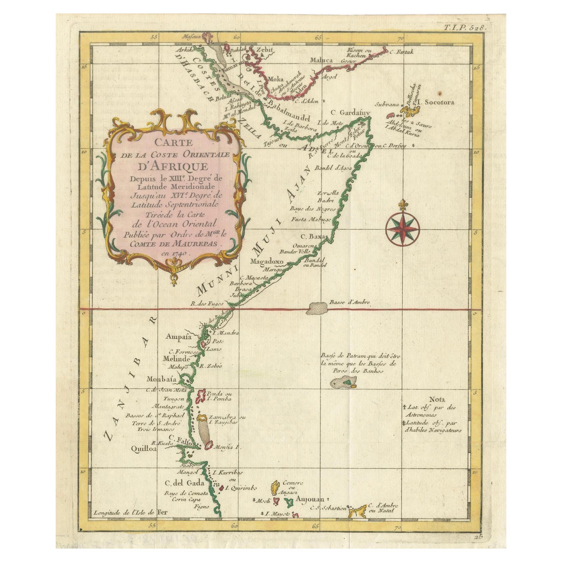
East African Coast – French Map by Bellin, Zanzibar to Arabia, 1740
Located in Langweer, NL
East African Coast – French Map by Bellin, Zanzibar to Arabia, 1740
This important French map depicts the eastern coast of Africa from Mozambique and Zanzibar northward to the Horn ...
Category
Antique 1740s French Maps
Materials
Paper