Items Similar to Map of Oxfordshire coloured 18th century engraving by Thomas Kitchin
Want more images or videos?
Request additional images or videos from the seller
1 of 9
Thomas KitchinMap of Oxfordshire coloured 18th century engraving by Thomas Kitchin1764
1764
$340.20
£250
€292.16
CA$470.44
A$512.19
CHF 273.49
MX$6,182.92
NOK 3,438.29
SEK 3,198.01
DKK 2,182.32
About the Item
To see our other original maps, scroll down to "More from this Seller" and below it click on "See all from this Seller" - or send us a message if you cannot find the poster you want.
Thomas Kitchin (1719 - 1784)
Map of Oxfordshire (1764)
Engraving with later hand-colouring
72 x 54 cm
This decorative map of Oxfordshire features a cartouche with three concentrating scholars and various educational trappings like rolls of parchment. The cartouche in the upper right corner dedicates the map to Charles Spencer, Duke of Marlborough, whose family seat of Blenheim Palace is just outside the city of Oxford. The map also sports a list of the University of Oxford's colleges, its rectories and vicarages, and a paragraph on the Earls of Oxford.
Thomas Kitchin was an English engraver and cartographer. He was born in London and was apprenticed to the map engraver Emanuel Bowen in 1732. He produced John Elphinstone's map of Scotland (1746), the Geographia Scotiae (1749), and The Small English Atlas (1749) with Thomas Jefferys. Kitchen worked for the London Magazine and for the King; there is also some debate as to whether he passed off other cartographers' work as his own.
- Creator:Thomas Kitchin (1710, British)
- Creation Year:1764
- Dimensions:Height: 28.35 in (72 cm)Width: 21.26 in (54 cm)
- Medium:
- Period:1760-1769
- Condition:Generally very good; central fold as issued, another fold to middle of top half, three tiny losses (a millimetre or two) just outside plate mark to left side.
- Gallery Location:London, GB
- Reference Number:1stDibs: LU795313473712
About the Seller
4.8
Vetted Professional Seller
Every seller passes strict standards for authenticity and reliability
Established in 2014
1stDibs seller since 2017
361 sales on 1stDibs
Typical response time: 13 hours
- ShippingRetrieving quote...Shipping from: London, United Kingdom
- Return Policy
More From This Seller
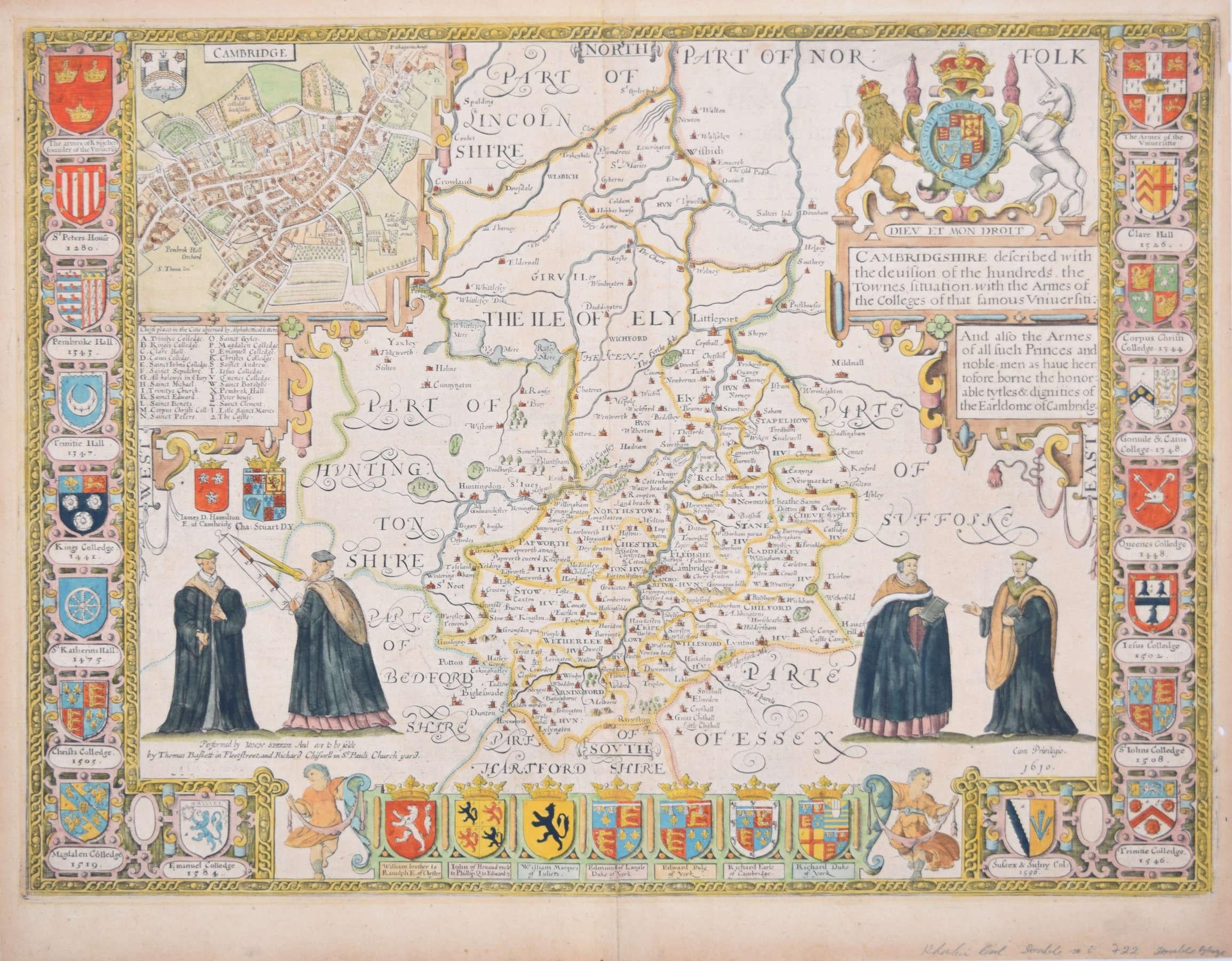
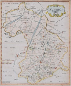
View AllCambridgeshire map 17th century engraving by John Speed
By John Speed
Located in London, GB
To see more, scroll down to "More from this Seller" and below it click on "See all from this Seller."
John Speed (1551 or 1552 - 1629)
Map of Cambridgeshire
Engraving with later hand colouring
39 x 53 cm
A beautifully coloured map of Cambridgeshire, with an antique description...
Category
1610s Landscape Prints
Materials
Engraving

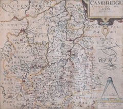
Map of Cambridgeshire, 18th century engraving by Sutton Nicholls
Located in London, GB
To see more, scroll down to "More from this Seller" and below it click on "See all from this Seller."
Sutton Nichols (1668 - 1729)
Map of Cambridgeshire
Engraving
43 x 36 cm
Signe...
Category
18th Century Landscape Prints
Materials
Engraving
Map of Oxfordshire by Joan Blaeu with college crests
By Joan (Johannes) Blaeu
Located in London, GB
To see our other original maps, scroll down to "More from this Seller" and below it click on "See all from this Seller" - or send us a message if you cannot find the poster you want....
Category
1660s Landscape Prints
Materials
Engraving
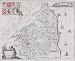
Map of Cambridge 18th century engraving by Sutton Nichols
Located in London, GB
To see more, scroll down to "More from this Seller" and below it click on "See all from this Seller."
Sutton Nichols (1668 - 1729)
Map of Cambridgeshire
Engraving
43 x 36 cm
Signed in plate lower left.
A beautifully coloured 18th century map engraving of Cambridgeshire. The map was produced by Robert Morden for publication in Edward Gibson's 1695 translation of William Camden's Britannia, a topographical and historical survey of Great Britain and Ireland produced to "restore antiquity to Britaine, and Britain to his antiquity" - a most noble aim.
William Camden (1551 - 1623) was an English antiquarian, historian, topographer, and herald, best known as the author of Britannia, the first chorographical survey of the islands of Great Britain and Ireland, and the Annales, the first detailed historical account of the Queen...
Category
18th Century Landscape Prints
Materials
Engraving
Cambridgeshire map 17th century engraving by Kip after Saxton
Located in London, GB
To see more, scroll down to "More from this Seller" and below it click on "See all from this Seller."
William Kip (active 1598 - 1610) after Christopher Saxton (1540 - 1610).
Map o...
Category
1630s Landscape Prints
Materials
Engraving
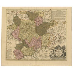
Map of Northumberland by Joannem Janssonium 17th century
Located in London, GB
To see our other original maps, scroll down to "More from this Seller" and below it click on "See all from this Seller" - or send us a message if you cannot find the poster you want....
Category
1640s Landscape Prints
Materials
Engraving
You May Also Like
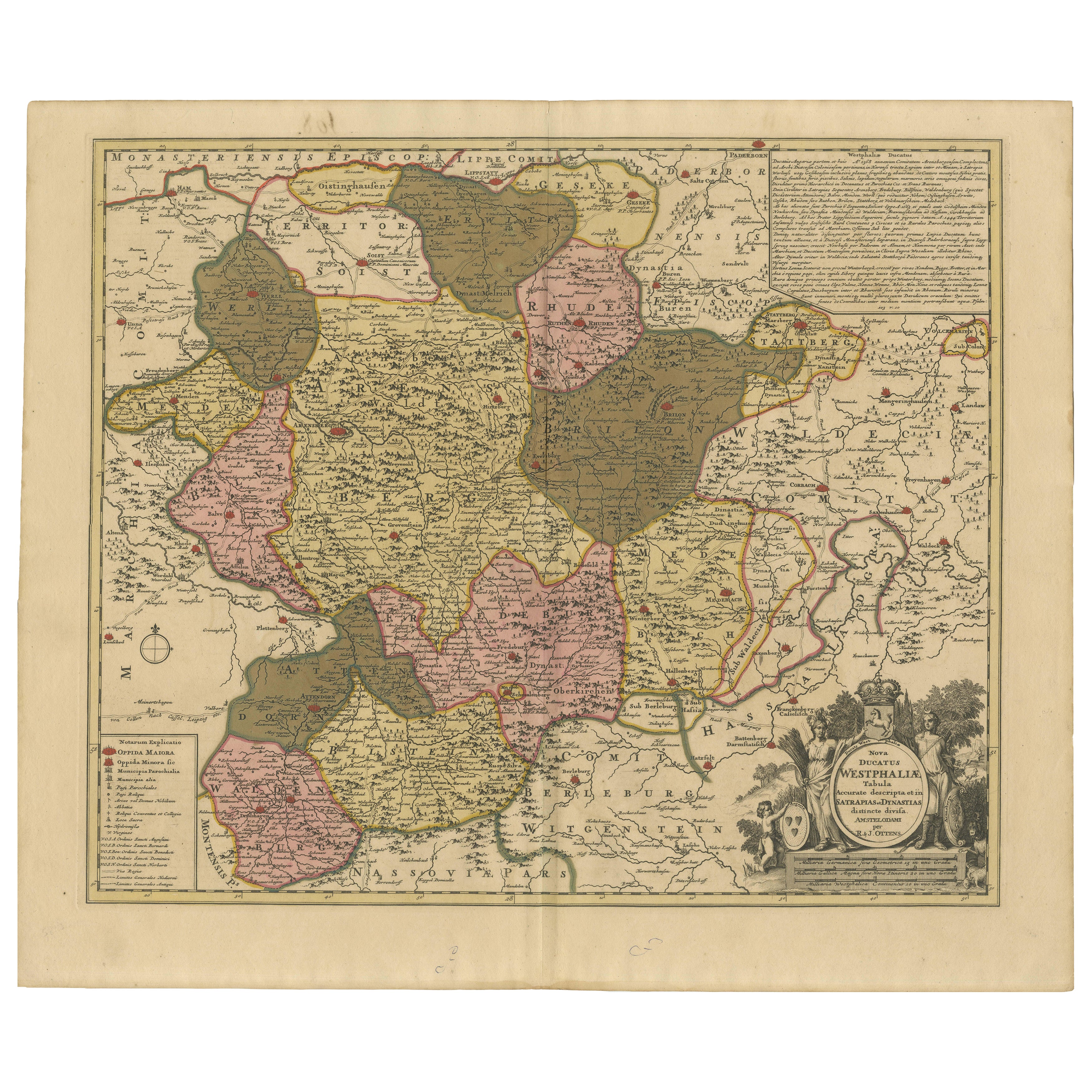
Hand-Colored Map of Westphalia – Copper Engraving by Ottens, Amsterdam c.1720
Located in Langweer, NL
Hand-Colored Map of Westphalia – Copper Engraving by Ottens, Amsterdam c.1720
This striking early 18th-century map titled *Nova Ducatus Westphaliae Tabula accurate descripta et in S...
Category
Antique Early 17th Century European Maps
Materials
Paper
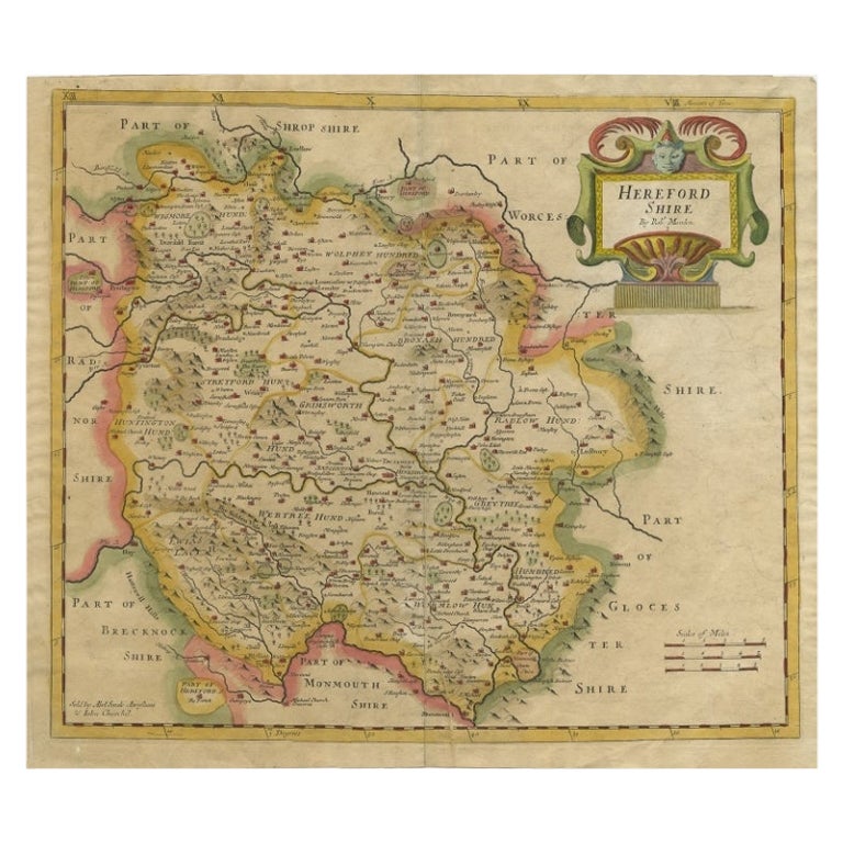
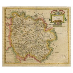
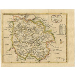
Antique Map of Herefordshire by Morden, c.1700
Located in Langweer, NL
Antique map titled 'Herefordshire'. Detailed map of the county of Herefordshire embellished with a decorative title cartouche. Three scales. Imprint of Abel Swale, Awnsham Churchill ...
Category
Antique 18th Century Maps
Materials
Paper
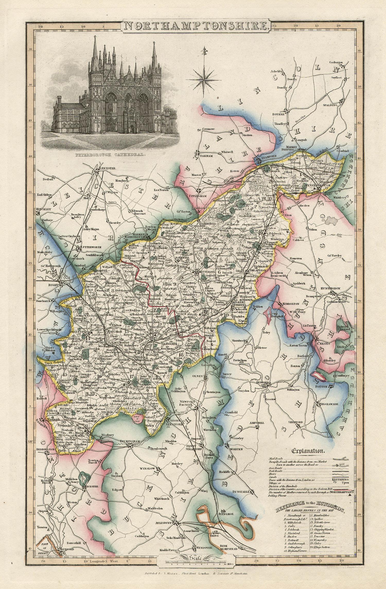
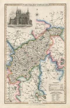
Northamptonshire, English County Antique map, 1847
By Isaac Slater
Located in Melbourne, Victoria
Steel-engraved map with original outline colouring by Isaac Slater. A detailed engraved map of the English county with title, scale, and key. Decorated with an uncoloured engraved view of 'Peterborough...
Category
19th Century Naturalistic Landscape Prints
Materials
Engraving
Rare Hand-Colored Map of Lyonnais Region in France by Frederik De Wit c. 1688
Located in Langweer, NL
Title: Rare Hand-Colored Map of Lyonnais Region by Frederik De Wit c. 1688
Description: This beautifully detailed map, "Gouvernement General du Lyonnois," showcases the Lyonnais reg...
Category
Antique 1680s Maps
Materials
Paper

Antique Map of Herefordshire
England
by R. Morden, 1708
Located in Langweer, NL
This antique County map of Herefordshire by Robert Morden was first published in 1701 in a work entitled 'The New Description and State of England'...
Category
Antique Early 18th Century Maps
Materials
Paper
Antique Map of Gloucestershire by Camden, c.1607
Located in Langweer, NL
Antique map titled 'Glocestriae comitatus olim sedes Dobunorum'. Map of Gloucestershire, England. This map originates from Camden?s 'Britannia' ...
Category
Antique 17th Century Maps
Materials
Paper

More Ways To Browse
Scotland Map
Antique Maps Scotland
Thomas Earl
R Marsh
Richard Devonshire
Rowland Langmaid
Sncf Dali
Spring Song Vintage Print
Thomas Moran Etching
Used Porta John
Valerie Thornton
Vintage United Airlines Travel Posters
William Stafford
Adolphe Beaufrere
African American Poster
Altman Luxembourg Lithograph
Ana Popescu
Aquatint India