Items Similar to China and Japan, English antique map by Alexander Keith Johnston, 1901


Want more images or videos?
Request additional images or videos from the seller
1 of 5
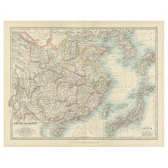
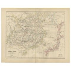
China and Japan, English antique map by Alexander Keith Johnston, 19011901
1901
$280
£212.64
€244.28
CA$394.73
A$419.68
CHF 226.95
MX$4,992.27
NOK 2,842.90
SEK 2,596.41
DKK 1,824.85
About the Item
'China and Japan', antique lithographic map by Keith Johnston.
Central vertical fold as issued.
495mm by 625mm (sheet)
Alexander Keith Johnston FRSE FRGS FGS FEGS LLD (1804 – 1871) was a Scottish geographer and cartographer. In 1826, he joined his brother William in a printing and engraving business, forming the well-known cartographical firm of W. and A. K. Johnston.
- Creation Year:1901
- Dimensions:Height: 19.49 in (49.5 cm)Width: 24.61 in (62.5 cm)
- Medium:
- Movement Style:
- After:Alexander Keith Johnston (1804 - 1871, British)
- Period:
- Condition:A couple of very faint marks in the margins. Central vertical fold as issued.
- Gallery Location:Melbourne, AU
- Reference Number:1stDibs: LU124427851472
About the Seller
5.0
Gold Seller
Premium sellers maintaining a 4.3+ rating and 24-hour response times
Established in 2005
1stDibs seller since 2019
634 sales on 1stDibs
Typical response time: 1 hour
- ShippingRetrieving quote...Shipping from: Melbourne, Australia
- Return Policy
More From This Seller
View AllIndia (Southern Sheet), English antique map by Alexander Keith Johnston, 1901
Located in Melbourne, Victoria
'India (Southern Sheet)', antique lithographic map by Keith Johnston.
Inset maps of 'Bombay Island & Town', 'Madras & Environs', and 'South-Eastern Provinces of India'.
Central vertical fold as issued.
495mm by 625mm (sheet)
Alexander Keith...
Category
Early 20th Century Victorian More Prints
Materials
Lithograph

Africa. North-East Part. Century Atlas antique vintage map
Located in Melbourne, Victoria
'The Century Atlas. Africa. North-East Part'
Original antique map, 1903.
Inset map of 'Nile Delta and Suez Canal'.
Central fold as issued. Map name and nu...
Category
Early 20th Century Victorian More Prints
Materials
Lithograph

Russia, Western and Southern Part. Century Atlas antique vintage map
Located in Melbourne, Victoria
'The Century Atlas. Russia, Western and Southern Part'
Original antique map, 1903.
Inset map tilted 'St Petersburg and Environs'.
Central fold as issued. Map name and number printe...
Category
Early 20th Century Victorian More Prints
Materials
Lithograph

Africa. North-West Part. Century Atlas antique vintage map
Located in Melbourne, Victoria
'The Century Atlas. Africa. Southern Part'
Original antique map, 1903.
Central fold as issued. Map name and number printed on the reverse corners.
Sheet 40cm by 29.5cm.
Category
Early 20th Century Victorian More Prints
Materials
Lithograph

South America, Eastern Part. Century Atlas antique vintage map
Located in Melbourne, Victoria
'The Century Atlas. South America. Eastern Part'
Original antique map, 1903.
Inset map 'Rio de Janeiro and Vicinity'.
Central fold as issued. Map name and number printed on the rev...
Category
Early 20th Century Victorian More Prints
Materials
Lithograph

Africa. Central. Century Atlas antique vintage map
Located in Melbourne, Victoria
'The Century Atlas. Africa. Central'
Inset map of 'Madagascar'.
Original antique map, 1903.
Central fold as issued. Map name and number printed on the reverse corners.
Sheet 29.5cm...
Category
Early 20th Century Victorian More Prints
Materials
Lithograph

You May Also Like
Antique Map of China, Taiwan, Korea, Hong-Kong and Japan, 1903
Located in Langweer, NL
Antique Map of China, Taiwan, Korea, Hong-Kong and Japan, 1903
Description: This antique map, titled "India (Southern Sheet) and the South Eastern Provinces," was engraved and publi...
Category
Early 20th Century Maps
Materials
Paper
Antique Map of China and Japan by A.K. Johnston, 1865
Located in Langweer, NL
Antique map titled 'China and Japan'. Depicting Eastern China, the Islands of Japan and more. This map originates from the ‘Royal Atlas of Modern Geography’ by Alexander Keith Johnst...
Category
Antique Mid-19th Century Maps
Materials
Paper

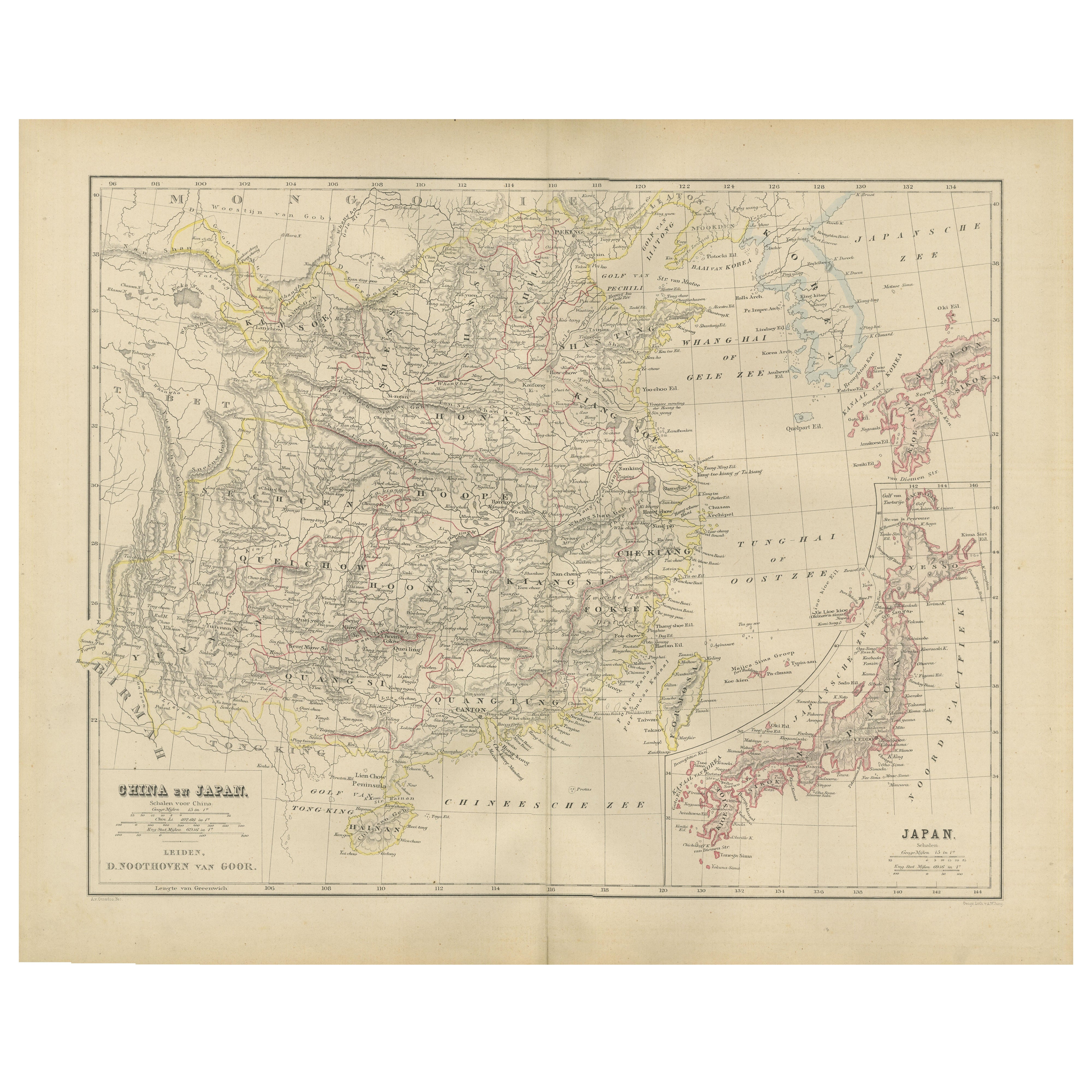
China and Japan Map with Korea – Nieuwe Hand-Atlas, Leiden 1876
Located in Langweer, NL
China and Japan Map with Korea – Nieuwe Hand-Atlas, Leiden 1876
This finely engraved 19th-century map titled “China en Japan” presents East Asia during a pivotal historical moment, ...
Category
Antique 1870s Dutch Maps
Materials
Paper
Antique Map of China and Japan by Johnson, 1872
Located in Langweer, NL
Antique map titled 'Johnson's China and Japan'. Map of China and Japan, with an inset map of the vicinity of Canton and Hong Kong. This map originates from 'Johnson's New Illustrated...
Category
Antique Late 19th Century Maps
Materials
Paper

$286 Sale Price
20% Off
Antique Map of China, Japan
Korea – Eastern Asia by Andriveau-Goujon, 1860
Located in Langweer, NL
Antique Map of China, Japan & Korea – Eastern Asia by Andriveau-Goujon, 1860
This beautifully hand-colored antique map, titled “Carte de la Chine, de la Corée et du Japon,” was publ...
Category
Antique Mid-19th Century French Maps
Materials
Paper
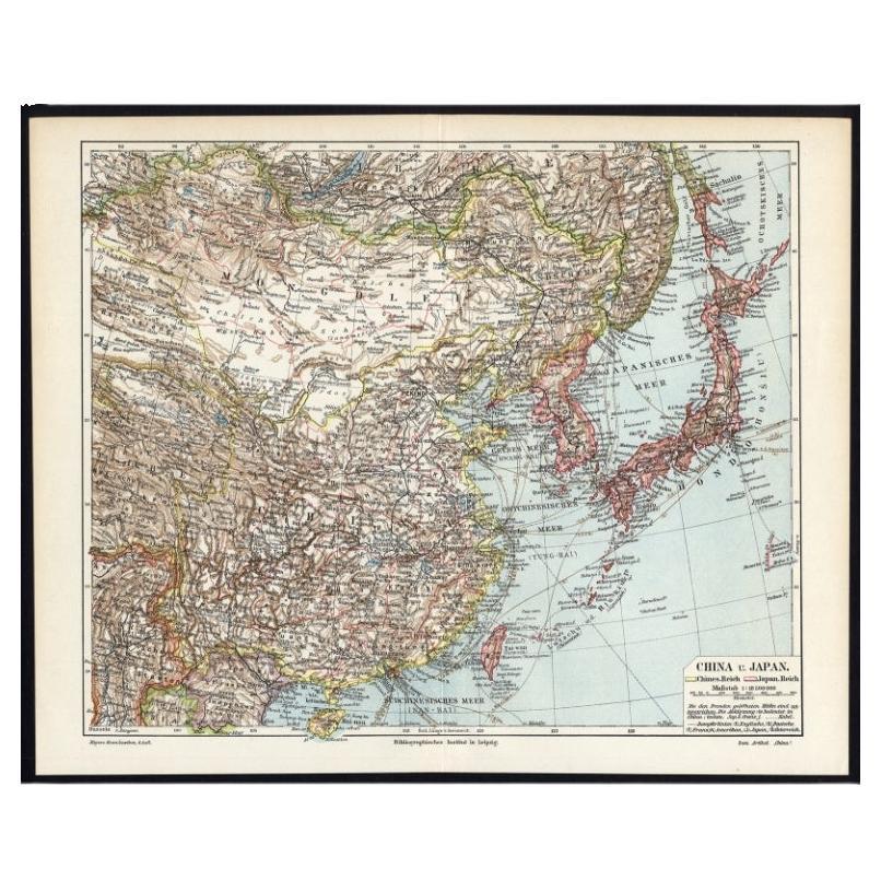
German Antique Map of China And Japan by Meyer, 1902
Located in Langweer, NL
Antique map titled 'China und Japan.' (Map of China and Japan). This attractive original old antique print / plate / map originates from the 6th edition of a famous German encycloped...
Category
20th Century Maps
Materials
Paper
$76 Sale Price
20% Off
More Ways To Browse
Antique English China
Shepard Fairey Interpol
Shepard Fairey Kurt Cobain
Soviet Rowing Poster
Stained Glass Rondels
Studio Ghibli
Toussaint Watches
Triumph Bicycles
Trooping The Colour Vintage Poster
Vintage Airborne Posters
Vintage Bahamas Travel Posters
Vintage Celtics Poster
Vintage Dr Gonzo
Vintage Food And Wine Posters
Vintage Formula Ford Racing
Vintage Horror Movie Posters Uk
Vintage Ibm Poster
Vintage Indian Film Posters