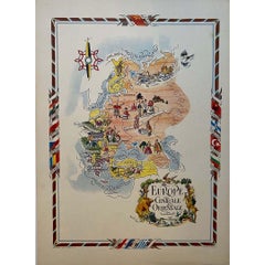
Items Similar to Original poster, titled “L’Europe Nouvelle” - political map of Europe


Want more images or videos?
Request additional images or videos from the seller
1 of 8
UnknownOriginal poster, titled “L’Europe Nouvelle” - political map of EuropeCirca 1919
Circa 1919
$2,373.56
£1,770.52
€2,000
CA$3,303.64
A$3,544.21
CHF 1,901.04
MX$42,671.84
NOK 23,964.87
SEK 21,852.64
DKK 15,241.52
About the Item
This fascinating original poster, titled “L’Europe Nouvelle”, presents a vivid political map of Europe and the world as reshaped by the Treaty of Versailles, signed in 1919 at the conclusion of the First World War. Designed as both a geopolitical document and a piece of popular education, this poster illustrates the dramatic territorial changes that followed the collapse of major empires, including Austro-Hungary, the Ottoman Empire, and Tsarist Russia.
Above the map, portraits of key world leaders — including Georges Clemenceau, David Lloyd George, Woodrow Wilson, and Vittorio Orlando — remind viewers of the figures who shaped this “new Europe.” The map itself highlights newly established or reconfigured nations such as Yugoslavia, Czechoslovakia, Poland, and the Baltic states, rendered in bright, contrasting colors to emphasize their modernity and political relevance.
In the lower portion of the poster, a trio of popular songs of the day is included, complete with lyrics and the names of composers and performers. This unusual combination of cartographic education and musical entertainment suggests the poster was marketed to a broad popular audience, blending postwar optimism with cultural vibrancy.
Card - War - 14-18
Borders and new states created by the Treaty of Versailles
Hayard Bookseller, Paris
- Creation Year:Circa 1919
- Dimensions:Height: 33.08 in (84 cm)Width: 22.84 in (58 cm)
- Medium:
- Period:
- Condition:Good condition, traces of folds, on linen.
- Gallery Location:PARIS, FR
- Reference Number:1stDibs: LU1792216981182
About the Seller
5.0
Platinum Seller
Premium sellers with a 4.7+ rating and 24-hour response times
Established in 2021
1stDibs seller since 2022
203 sales on 1stDibs
Typical response time: 1 hour
- ShippingRetrieving quote...Shipping from: PARIS, France
- Return Policy
More From This Seller
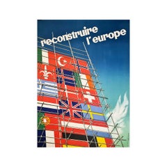
View AllOriginal poster created by Alban Wyss the European reconstruction
Located in PARIS, FR
Beautiful poster created by Alban Wyss. ERP To rebuild Europe.
The European Recovery Program (ERP), later known as the Marshall Plan, was a U.S.-sponsored...
Category
1940s Prints and Multiples
Materials
Paper
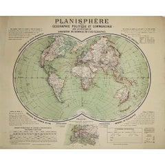
Circa 1900 original poster Planisphère de géographie politique et commercial
Located in PARIS, FR
This circa 1900 original poster, "Planisphère de Géographie Politique et Commerciale," is a fascinating artifact of early 20th-century cartography, created by H. Bouthillier de Beaum...
Category
Early 1900s Prints and Multiples
Materials
Paper, Lithograph
Jacques Liozu
s 1951 illustrated map of Central and Eastern Europe
By Jacques Liozu
Located in PARIS, FR
Jacques Liozu's 1951 illustrated map of Central and Eastern Europe is a cartographic work of great beauty and precision. Jacques Liozu, the famous French artist-cartographer, created...
Category
1950s Prints and Multiples
Materials
Paper, Lithograph
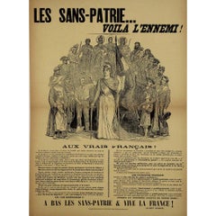
Early 20th-century french propaganda poster : The Stateless… Here is the Enemy!
Located in PARIS, FR
This early 20th-century propaganda poster, titled Les Sans-Patrie… Voilà l’Ennemi! (The Stateless… Here is the Enemy!), is a striking testament to the heated nationalist and anti-republican sentiments that surged in France in the years leading up to World War I. Created by E. Millo and published by Le Petit Patriote, the poster presents an impassioned defense of French patriotism while identifying internal enemies—those deemed to lack allegiance to the nation.
At the time of its creation, France was deeply divided between nationalists and republicans, between those who saw France as a Catholic, traditionalist nation and those who pushed for a secular, progressive Republic. The Dreyfus Affair (1894–1906) had left the country bitterly fractured, with intense debates over loyalty, national identity, and military values.
This poster embodies the sentiments of right-wing conservatives who viewed the Republic’s secularism, its tolerance of political opposition, and its social reforms as signs of national decay. The target of their ire was the so-called Sans-Patrie—those accused of betraying France by undermining its traditional values.
The poster’s dramatic black-and-white illustration is designed to evoke strong patriotic emotions. At its center stands a personification of France, likely inspired by Marianne, the symbolic female figure representing the French Republic. She holds a French flag and a sword, embodying strength and resistance against the perceived enemies of the nation.
Surrounding her are figures from different walks of life—workers, mothers, soldiers, and historical figures—suggesting that true French citizens stand together against those who would weaken the country.
The bold headline, “Les Sans-Patrie… Voilà l’Ennemi!”, leaves no room for ambiguity. It directly accuses those who lack national loyalty as traitors, rallying "true" French citizens to defend the homeland.
The text addresses “Aux Vrais Français” (To True French People), making a direct appeal to patriotic sentiment. It warns readers about anti-national forces, particularly socialists, internationalists, and secularists, who are accused of corrupting French youth, undermining the military, and weakening national unity.
Among its claims, the poster states that:
French schools are being used to indoctrinate children against patriotism.
Military service, a key element of national strength, is under attack by those who wish to weaken France.
The nation’s historical heroes and martyrs are being forgotten, replaced by values that do not serve the country’s survival.
The final rallying cry at the bottom, “À bas les sans-patrie & Vive la France...
Category
Early 1900s Prints and Multiples
Materials
Paper, Lithograph, Linen
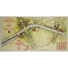
1937 original poster illustrated map of the Exposition Internationale
Located in PARIS, FR
This 1937 original poster presents a detailed illustrated map of the Exposition Internationale des Arts et Techniques dans la Vie Moderne, held in Paris. The International Exposition...
Category
1930s Prints and Multiples
Materials
Paper, Lithograph, Linen
1947 original map Gouvernement Généraux du Poitou, du Pays d
Aunis
Located in PARIS, FR
The 1947 original map Gouvernement Généraux du Poitou, du Pays d'Aunis et de Saintonge Angoumois, created by Louis Larmat and printed by Dorel in Paris, is a beautifully detailed cartographic representation of a historically significant region in western France. This map, part of Larmat’s extensive body of work, is known for its artistic craftsmanship and geographical precision, offering a comprehensive view of the historical administrative regions of Poitou, Aunis, Saintonge, and Angoumois, which played key roles in the political and cultural history of France.
Louis Larmat is celebrated for his contributions to cartography, particularly for his ability to merge historical context, topographical detail, and aesthetic elegance in his maps. His works, especially those focusing on the vinicultural regions of France, are highly respected for their accuracy and artistry. This particular map, although focusing on a more political and historical aspect rather than the wine regions he is most famous for, continues his tradition of detailed regional documentation. Larmat’s cartographic works often transcended the realm of simple geographical depiction, becoming historical documents that encapsulate the cultural essence of the regions they portray.
This map illustrates the general governments (administrative divisions) of the provinces of Poitou, Aunis, Saintonge, and Angoumois, regions that are steeped in history. These areas, situated along France’s western coastline, have been integral to the country’s political, economic, and cultural development over centuries. The region of Poitou, for example, is historically known as the birthplace of Eleanor of Aquitaine...
Category
1940s Prints and Multiples
Materials
Paper, Lithograph

You May Also Like
Antique Map of the European Continent, 1882
Located in Langweer, NL
Antique map titled 'Europe'. Old map of the European continent. This map originates from 'The Royal Atlas of Modern Geography, Exhibiting, in a Series of ...
Category
Antique 19th Century Maps
Materials
Paper

Political Map of Europe: Early 19th Century, from the 1802 Tardieu Atlas
Located in Langweer, NL
Antique Map Description
Title: Carte Générale et Politique de l'Europe
Publication Details:
- **Atlas Title:** Nouvel Atlas Universel de Géographie Ancienne et Moderne
- **Purpose...
Category
Antique Early 1800s French Maps
Materials
Paper

$455 Sale Price
20% Off
Antique Map of Europe, 1903, with Intricate Political Boundaries and Rich Detail
Located in Langweer, NL
Title: Antique Map of Europe, 1903, with Intricate Political Boundaries and Rich Detail
Description:
This antique map, titled "Europe," is a finely engraved and beautifully colored ...
Category
Early 20th Century Maps
Materials
Paper

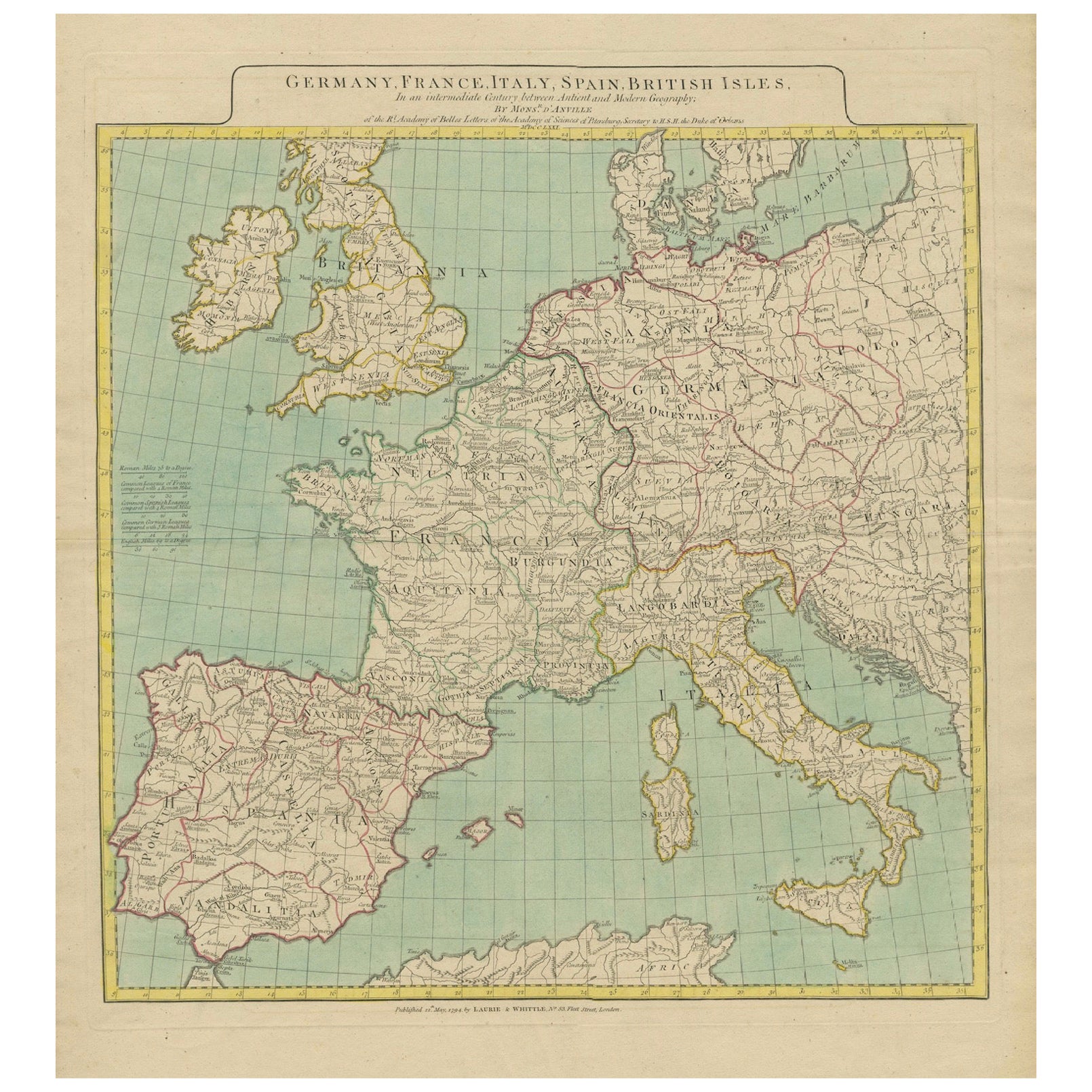
Map of Europe Highlighting Ancient and Modern Geographical Divisions (1794)
Located in Langweer, NL
Map of Europe Highlighting Ancient and Modern Geographical Divisions (1794). Germany, France, Italy, Spain, and the British Isles – Map by D’Anville (1794).
This detailed 18th-cent...
Category
Antique 1790s Maps
Materials
Paper
$1,604 Sale Price
20% Off
Antique Map of Europe from an Old Dutch School-Atlas, 1852
Located in Langweer, NL
Antique map titled 'Europa'. Map of Europe. This map originates from 'School-Atlas van alle deelen der Aarde' by Otto Petri.
Artists and Engravers: Published by A. Baedeker (Otto...
Category
Antique 19th Century Maps
Materials
Paper

Antique Map of the Europe Continent, 1880
Located in Langweer, NL
Antique map titled 'Europe'. Old map of the European continent. This map originates from 'Géographie Universelle Atlas-Migeon' by J. Migeon.
Artists an...
Category
Antique 19th Century Maps
Materials
Paper
