Objekte ähnlich wie Ancient Egypt – Nile Valley Map by d’Anville, Classical Antiquity, c.1765


Möchten Sie mehr Bilder oder Videos?
Zusätzliche Bilder oder Videos von dem*der Anbieter*in anfordern
1 von 9
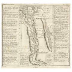
Ancient Egypt – Nile Valley Map by d’Anville, Classical Antiquity, c.1765
570 €Einschließlich MwSt.
Angaben zum Objekt
Ancient Egypt – Nile Valley Map by d’Anville, Classical Antiquity, c.1765
This finely engraved map depicts Ancient Egypt as understood through classical sources, extending along the Nile Valley from the Mediterranean Delta southward into Nubia, with adjacent regions of Arabia Petraea and the Red Sea coast. The map is titled “Ægyptus Antiqua” and was compiled by Jean-Baptiste Bourguignon d’Anville, one of the most influential and scholarly cartographers of the 18th century.
D’Anville’s approach marked a decisive shift away from speculative geography. Drawing on ancient Greek and Roman authors such as Herodotus, Strabo, Pliny, and Ptolemy, he sought to reconstruct the geography of antiquity with critical rigor. Cities, nomes, temples, and classical place names are carefully plotted along the Nile, offering a structured and historically grounded vision of Pharaonic Egypt as interpreted through classical antiquity.
The Nile dominates the composition, rendered as the organizing spine of Egyptian civilization. Branches of the Delta, desert regions, and mountain ranges are delicately engraved, while subtle hand color highlights coastlines and regional boundaries without overwhelming the clarity of the map. To the east, the Red Sea and Arabian Peninsula provide geographical context for ancient trade routes and cultural exchange.
Visually, the map balances scholarship and elegance. The restrained engraving style, generous white space, and vertical format give it a calm, architectural presence, making it particularly attractive for interior display. It works equally well as a collector’s piece or as a refined statement map in both classic and contemporary settings.
This map is highly sought after by collectors of Egyptology, classical history, and Enlightenment cartography, and it pairs beautifully with other 18th-century maps of North Africa, the Mediterranean, or the ancient world.
Condition report
Good condition overall. Light age toning. Original outline hand color. Plate mark visible. Margins intact. Right margin tight. Strong paper.
Framing tips
A wide off-white or light sand-colored mat enhances the vertical composition and emphasizes the Nile’s flow through the map. A medium to dark wood frame or softly ebonized frame gives the piece a refined, museum-style appearance, suitable for both residential and hospitality interiors.
Technique: Copper engraving with contemporary outline hand color
Maker: Jean-Baptiste Bourguignon d’Anville, France, c.1765
- Maße:Höhe: 55,7 cm (21,93 in)Breite: 37,5 cm (14,77 in)Tiefe: 0,2 mm (0,01 in)
- Materialien und Methoden:Papier,Graviert
- Herkunftsort:
- Zeitalter:1760–1769
- Herstellungsjahr:circa 1765
- Zustand:Good condition overall. Light age toning. Original outline hand color. Plate mark visible. Margins intact. Right margin tight. Strong paper.
- Anbieterstandort:Langweer, NL
- Referenznummer:Anbieter*in: BG-14128-161stDibs: LU3054348017302
Anbieterinformationen
5,0
Anerkannte Anbieter*innen
Diese renommierten Anbieter*innen sind führend in der Branche und repräsentieren die höchste Klasse in Sachen Qualität und Design.
Platin-Anbieter*in
Premium-Anbieter*innen mit einer Bewertung über 4,7 und 24 Stunden Reaktionszeit
Gründungsjahr 2009
1stDibs-Anbieter*in seit 2017
2.813 Verkäufe auf 1stDibs
Typische Antwortzeit: 1 Stunde
- VersandAngebot wird abgerufen …Versand von: Langweer, Niederlande
- Rückgabebedingungen
Einige Inhalte dieser Seite wurden automatisch übersetzt. Daher kann 1stDibs nicht die Richtigkeit der Übersetzungen garantieren. Englisch ist die Standardsprache dieser Website.
Mehr von diesem*dieser Anbieter*in
Alle anzeigenEgypt
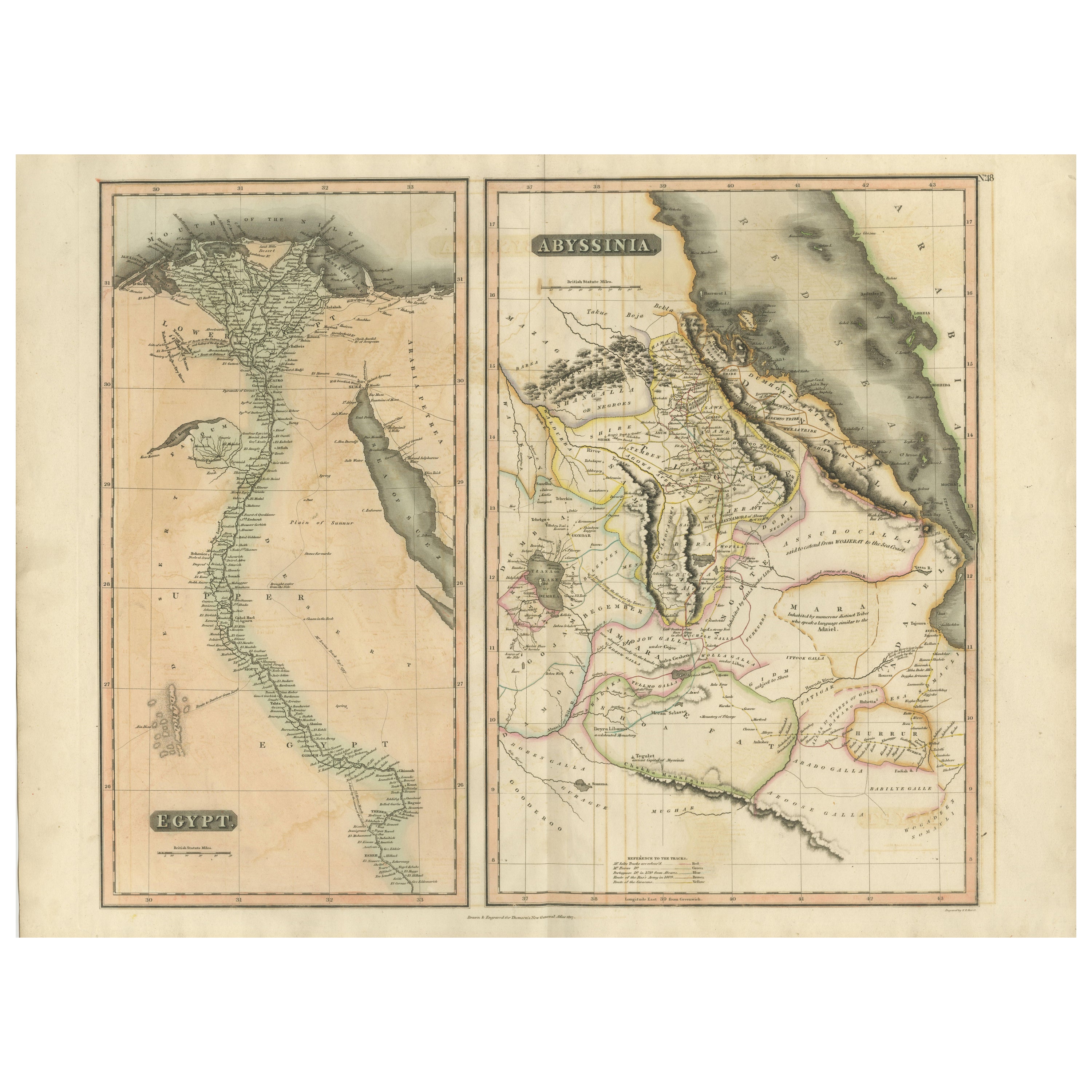
Abyssinia – Original Nile Valley and Horn of Africa Maps, c.1817
Egypt & Abyssinia – Nile Valley and Horn of Africa Maps, c.1817–1820
This refined early 19th-century map composition presents two related geographic views of Northeast Africa: Egypt...
Kategorie
Antik, 1810er, Britisch, Landkarten
Materialien
Papier
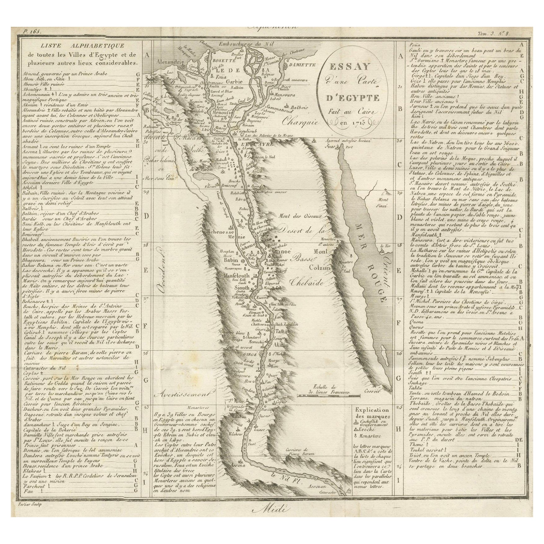
Antike Karte von Ägypten und dem Niltal mit Städteverzeichnis, 1715
Antike Karte von Ägypten mit dem Titel "Essay d'une Carte d'Égypte Fait au Caire en 1715".
Diese fein gestochene Karte zeigt eine detaillierte Darstellung Ägyptens entlang des Nils...
Kategorie
Antik, Frühes 18. Jahrhundert, Französisch, Landkarten
Materialien
Papier
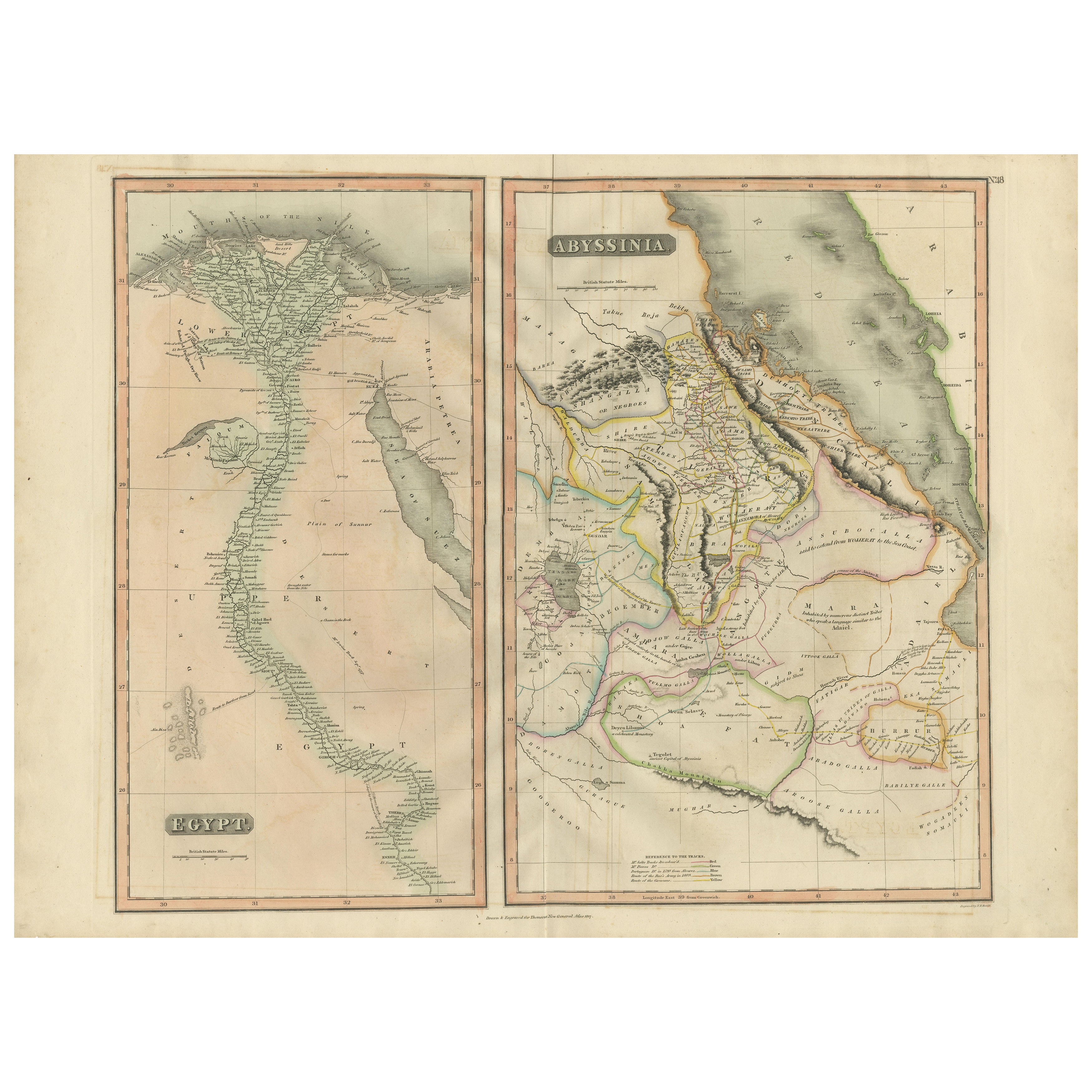
Egypt and Abyssinia – Nile Valley
Horn of Africa Maps, c.1817–1820
Egypt and Abyssinia – Nile Valley & Horn of Africa Maps, c.1817–1820
This refined early 19th-century paired map presents Egypt and Abyssinia (Ethiopia) as two complementary geograph...
Kategorie
Antik, 1810er, Britisch, Landkarten
Materialien
Papier
Antike Karte von Ägypten mit detailliertem Ausschnitt des Nildeltas, ca. 1799
Antike Karte von Ägypten mit detailliertem Ausschnitt des Nildeltas, ca. 1799
Diese fein gestochene antike Karte mit dem Titel Carte Physique et Politique de l'Égypte (Physikalische...
Kategorie
Antik, Anfang 1800, Französisch, Landkarten
Materialien
Papier

Antike antike Karte des Nile, Ägypten und des Roten Meeres von Bachiene, 1765
Antike Karte mit dem Titel 'De XIde Landkaart verbeeldende Egypte en de Woestyne der Schelf-Zee (..) Karte des biblischen Ägypten und des Roten Meeres. Mit Titelkartusche, Kompassros...
Kategorie
Antik, 18. Jahrhundert, Landkarten
Materialien
Papier

Antike antike Karte des antiken Ägyptens mit auch der Darstellung des Nile-Fluss und des Roten Meeres, 1845
Antike Karte Ägypten mit dem Titel 'General Karte von Alt Aegypten von A.H. Brué'. Große Karte von Ägypten, auf der auch der Nil und das Rote Meer eingezeichnet sind. Quelle unbekann...
Kategorie
Antik, 19. Jahrhundert, Landkarten
Materialien
Papier

Das könnte Ihnen auch gefallen
Karte von Nubia und Abissinia – Original-Radierung von Antonio Zatta – 1784
Diese Karte von Nubien und Abissinien ist eine Radierung von Antonio Zatta aus dem Jahr 1784 in Venedig.
Der Erhaltungszustand des Kunstwerks ist gut, abgesehen von dem abgenutzten ...
Kategorie
1770er, Landschaftsdrucke
Materialien
Radierung

Antike antike Karte des antiken Griechenlands - Boeotia, Thebes, 1787
Großartige Karte des antiken Griechenlands. Zeigt die Region Böotien, einschließlich Theben
Gezeichnet von J.D. Barbie Du Bocage
Kupferstich von P.F Tardieu
Originaler handk...
Kategorie
Antik, 1780er, Französisch, Sonstiges, Landkarten
Materialien
Papier

Original Antike Karte des antiken Griechenlands, Achaia, Corinth, 1786
Großartige Karte des antiken Griechenlands. Zeigt die Region Thessalien, einschließlich des Berges Olympus
Gezeichnet von J.D. Barbie Du Bocage
Kupferstich von P.F Tardieu
O...
Kategorie
Antik, 1780er, Französisch, Sonstiges, Landkarten
Materialien
Papier

Afrika. Nord-Ost-Teil. Antike Atlas-Vintage-Karte
Der Jahrhundertatlas. Afrika. Nordöstlicher Teil
Originale antike Karte, 1903.
Inspektionskarte "Nildelta und Suezkanal".
Zentrale Falte wie ausgestellt. Name und Nummer der Karte ...
Kategorie
Frühes 20. Jahrhundert, Viktorianisch, Mehr Drucke
Materialien
Lithografie

Map des Heiligen Landes „Carte de la Syrie et de l
Egypte“ von Pierre Lapie
Von Pierre M. Lapie
Dies ist eine Karte des antiken Syriens und Ägyptens aus dem frühen 19. Jahrhundert mit dem Titel "Carte de la Syrie et de l'Egypte anciennes/dressée par M. Lapie, Colonel d'Etat Maj...
Kategorie
1830er, Landschaftsdrucke
Materialien
Gravur

536 € Verkaufspreis
20 % Rabatt
Original Antike Karte von Afrika von Dower, um 1835
Schöne Karte von Afrika
Gezeichnet und gestochen von J. Dower
Herausgegeben von Orr & Smith. C.1835
Ungerahmt.
Kostenloser Versand
Kategorie
Antik, 1830er, Englisch, Landkarten
Materialien
Papier
