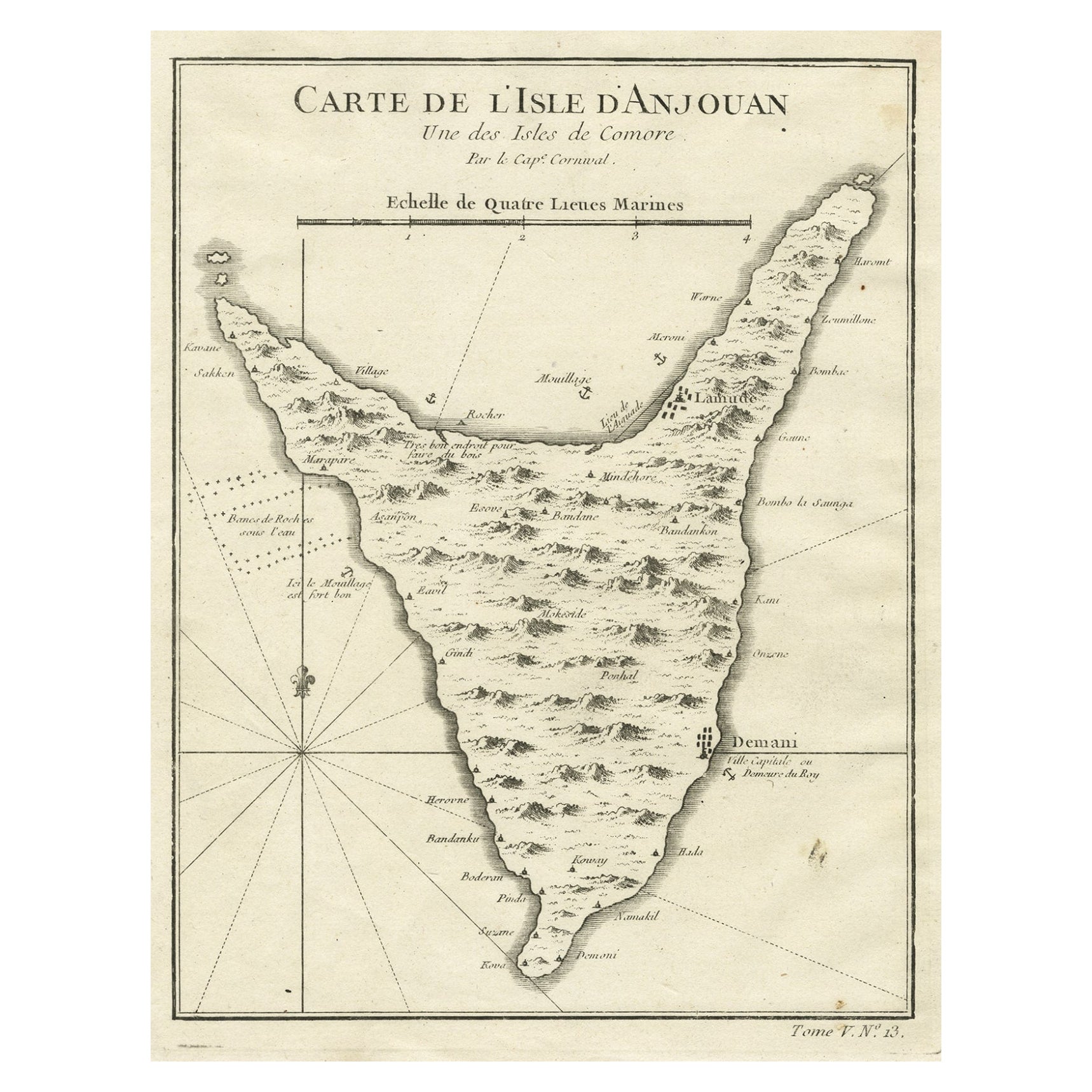
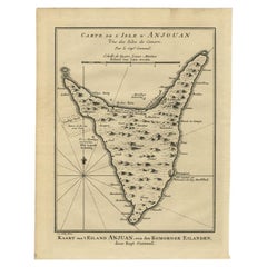
Objekte ähnlich wie Anjouan Island, Comoros – French Naval Sea Chart by Bellin, c.1765

Möchten Sie mehr Bilder oder Videos?
Zusätzliche Bilder oder Videos von dem*der Anbieter*in anfordern
1 von 10
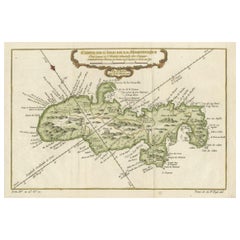
Anjouan Island, Comoros – French Naval Sea Chart by Bellin, c.1765
340 €Einschließlich MwSt.
Angaben zum Objekt
Anjouan Island, Comoros – French Naval Sea Chart by Bellin, c.1765
This finely engraved French sea chart depicts the island of Anjouan (Ndzuwani), one of the Comoros Islands in the western Indian Ocean. The map is titled “Carte de l’Isle d’Anjouan, Une des Isles de Comore” and was engraved under the direction of Jacques-Nicolas Bellin, Hydrographer to the French King. It belongs to Bellin’s authoritative hydrographic output for the Dépôt des cartes et plans de la Marine and was published in Paris around 1760–1770.
The chart was compiled from naval reconnaissance and maritime reports and reflects France’s growing strategic and commercial interests along the East African and Indian Ocean trade routes. Anjouan was an important stopover between Madagascar, the Swahili Coast, Arabia, and India, and the map is clearly intended for practical navigation rather than purely decorative purposes.
The coastline is shown in careful detail, with anchorages, coastal profiles, reefs, and shallow banks clearly marked. Interior relief is rendered pictorially, emphasizing the island’s mountainous terrain. Numerous settlements are identified, including Demani, labeled as “Ville capitale ou Demeure du Roy,” indicating the royal residence and political center of the island at the time. A compass rose and marine scale in lieues marines complete the navigational apparatus.
This engraving is an excellent example of mid-18th-century French naval cartography, combining accuracy, clarity, and restrained elegance. Bellin’s charts are particularly sought after for their reliability and historical importance, and maps of the Comoros appear far less frequently on the market than his work on the Mediterranean or Atlantic regions.
The vertical island composition makes this chart especially attractive for interior display, while its clear colonial and maritime context appeals strongly to collectors of African, Indian Ocean, and French naval cartography.
Condition report
Good condition overall. Light age toning consistent with period. Minor scattered spots and faint handling marks. Original hand coloring. Plate mark visible. Full margins.
Framing tips
This map works beautifully with a warm off-white or light sand-colored mat to echo the paper tone. A darker wood frame (walnut or ebonized pearwood) enhances the vertical island shape and gives the piece a refined, museum-style presence. Non-reflective glass is recommended to preserve detail and color.
Technique: Copper engraving with contemporary hand color
Maker: Jacques-Nicolas Bellin, France, c.1765
- Maße:Höhe: 25,2 cm (9,93 in)Breite: 19,5 cm (7,68 in)Tiefe: 0,2 mm (0,01 in)
- Materialien und Methoden:Papier,Graviert
- Herkunftsort:
- Zeitalter:1760–1769
- Herstellungsjahr:circa 1765
- Zustand:Good condition overall. Light age toning consistent with period. Minor scattered spots and faint handling marks. Original hand coloring. Plate mark visible. Full margins.
- Anbieterstandort:Langweer, NL
- Referenznummer:Anbieter*in: BG-14128-11stDibs: LU3054348016472
Anbieterinformationen
5,0
Anerkannte Anbieter*innen
Diese renommierten Anbieter*innen sind führend in der Branche und repräsentieren die höchste Klasse in Sachen Qualität und Design.
Platin-Anbieter*in
Premium-Anbieter*innen mit einer Bewertung über 4,7 und 24 Stunden Reaktionszeit
Gründungsjahr 2009
1stDibs-Anbieter*in seit 2017
2.813 Verkäufe auf 1stDibs
Typische Antwortzeit: 1 Stunde
- VersandAngebot wird abgerufen …Versand von: Langweer, Niederlande
- Rückgabebedingungen
Einige Inhalte dieser Seite wurden automatisch übersetzt. Daher kann 1stDibs nicht die Richtigkeit der Übersetzungen garantieren. Englisch ist die Standardsprache dieser Website.
Mehr von diesem*dieser Anbieter*in
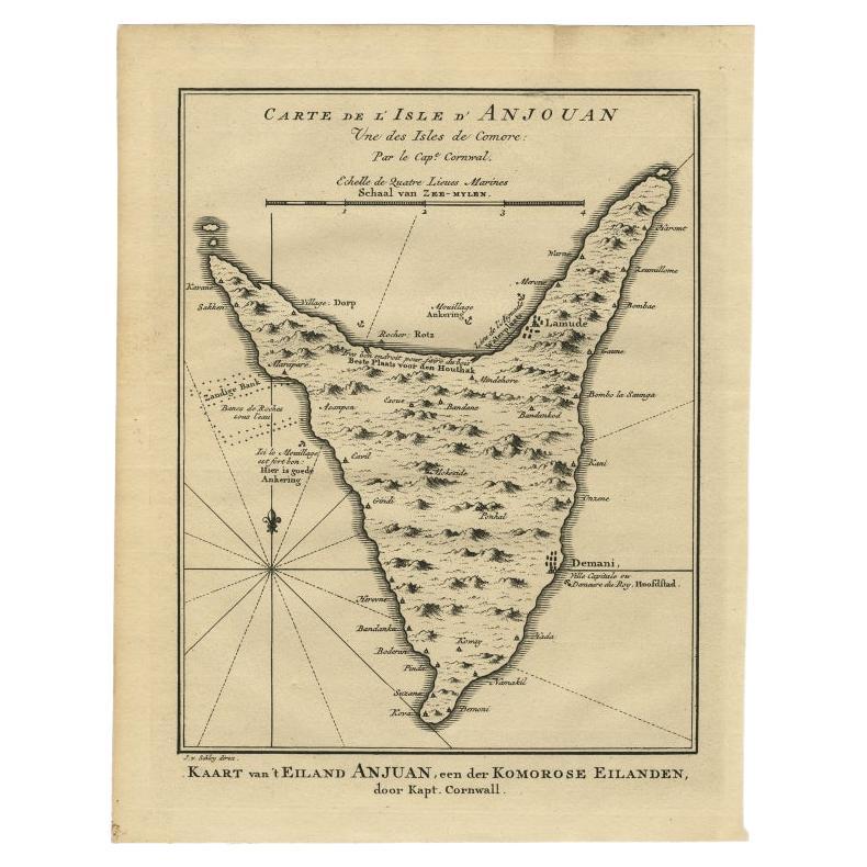
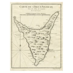
Alle anzeigenAntike Karte der Insel Anjouan oder Ndzuani, Teil der Comoros, 1749
Antike Karte mit dem Titel 'Carte de L'Isle D'Anjouan - Kaart van 't Eiland Anjouan'. Antike Original-Landkarte von Anjouan, auch bekannt als Ndzuwani oder Nzwani, oder, historisch g...
Kategorie
Antik, 18. Jahrhundert, Landkarten
Materialien
Papier
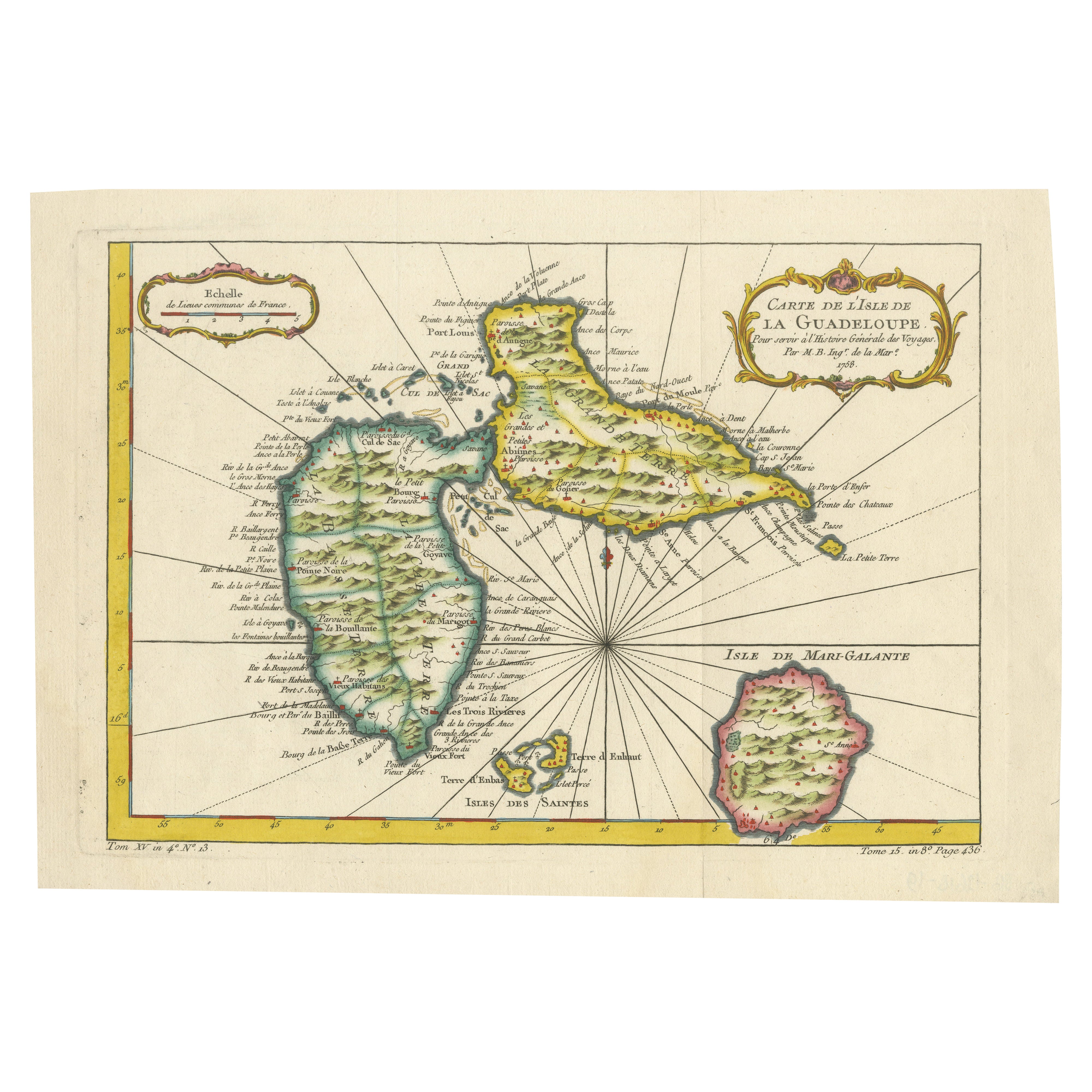
1758 Bellin Karte von Guadeloupe und Marie-Galante - Karibische Inseln
Vielen Dank, dass Sie das richtige Datum auf der Karte vermerkt haben. Hier ist Ihre **aktualisierte Klartext-Katalogliste**:
---
**Titel (weniger als 80 Zeichen):**
1758 Bellin Ka...
Kategorie
Antik, Mitte des 18. Jahrhunderts, Französisch, Landkarten
Materialien
Papier

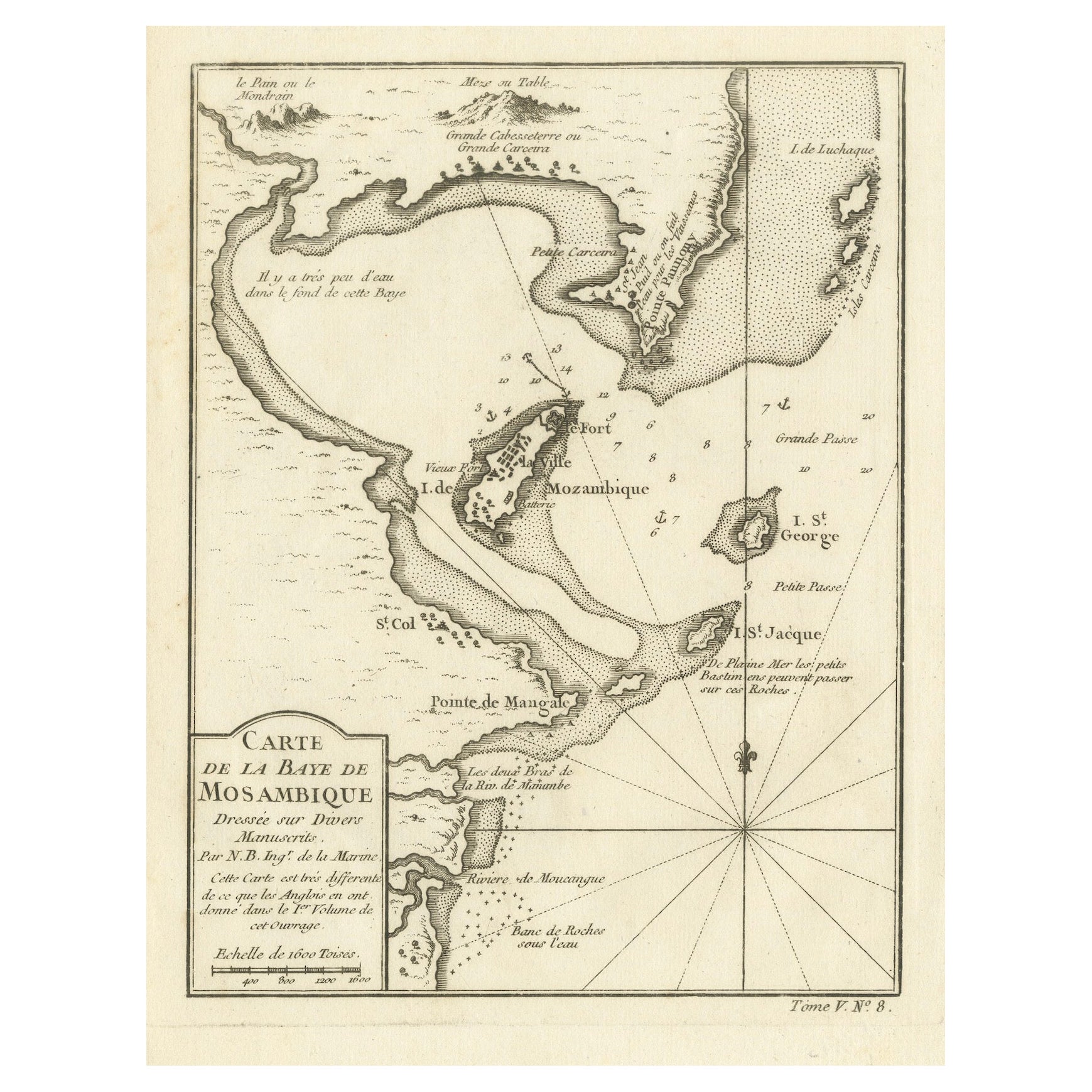
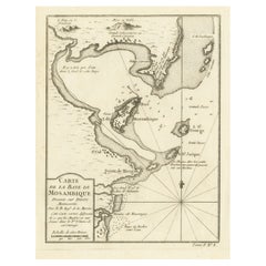
Mozambique Bay – French Naval Sea Chart by Bellin, c.1765
Mozambique Bay – French Naval Sea Chart by Bellin, c.1765
This detailed French sea chart depicts the Bay of Mozambique and the strategically vital island settlement of Mozambique, s...
Kategorie
Antik, 1760er, Französisch, Landkarten
Materialien
Papier
Antike Karte von Anjouan oder Ndzuani, Insel der Comoros, 1748
Antike Karte mit dem Titel 'Carte de L'Isle D'Anjouan'. Antike Original-Landkarte von Anjouan, auch bekannt als Ndzuwani oder Nzwani oder, historisch gesehen, als Johanna, einer auto...
Kategorie
Antik, 18. Jahrhundert, Landkarten
Materialien
Papier
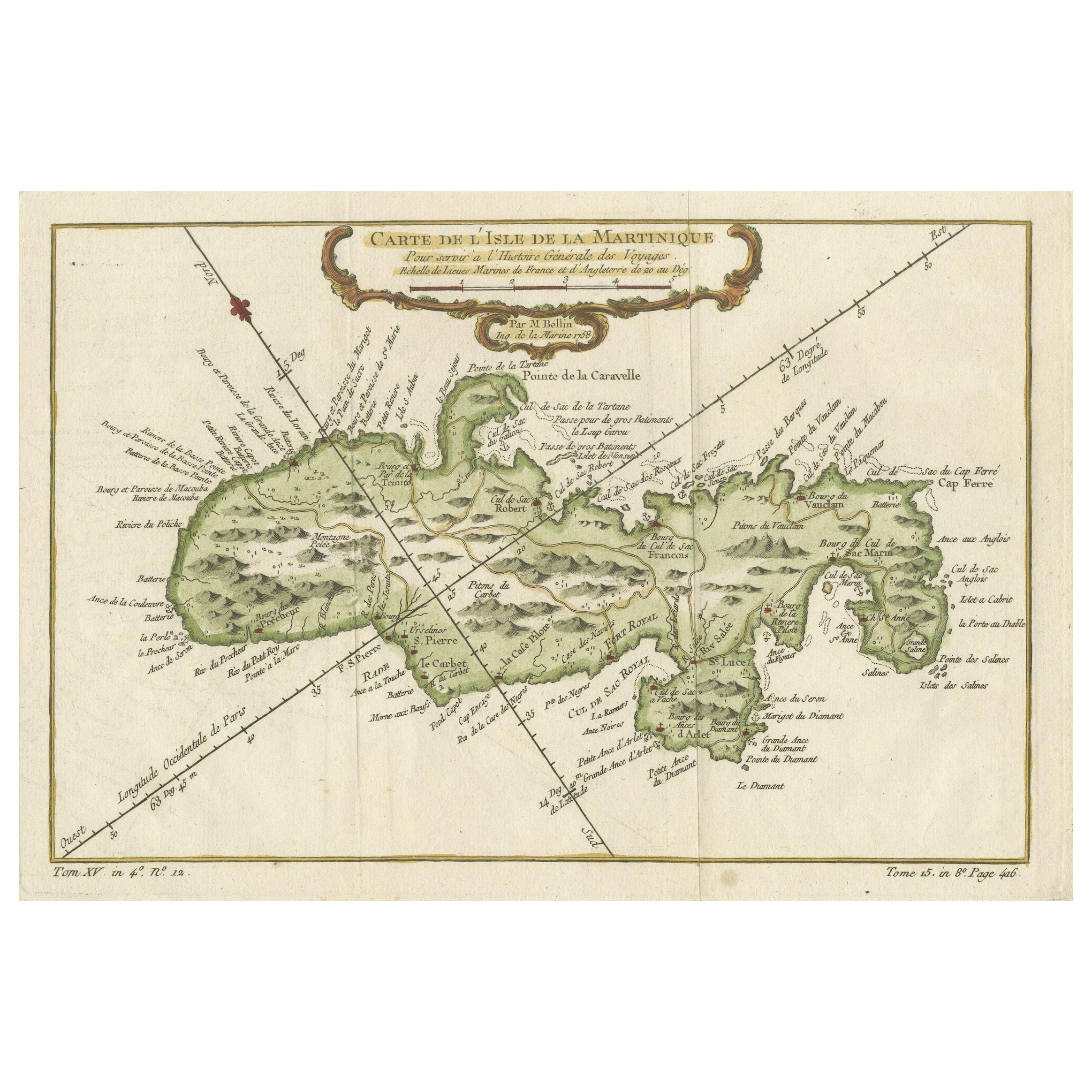
Martinique Karte von Rigobert Bonne - Antike französische Karte, um 1768
Karte von Martinique von Rigobert Bonne, um 1768
Dies ist eine detaillierte antike Karte von Martinique mit dem Titel "Isle de la Martinique", gestochen von Rigobert Bonne um 1768 f...
Kategorie
Antik, 1760er, Französisch, Landkarten
Materialien
Papier

Martinique-Insel in der Karibik von Bellin Original Antike Karte, 1780
Diese Karte aus der Mitte des 18. Jahrhunderts, "Carte de l'Isle de la Martinique pour servir a l'historie generale des voyages", wurde 1780 von M. Bellin in Paris herausgegeben. Es ...
Kategorie
Antik, Spätes 18. Jahrhundert, Landkarten
Materialien
Papier
224 € Verkaufspreis
20 % Rabatt
Das könnte Ihnen auch gefallen
Westafrikanische Westküste, Guinea und Sierra Leone: Eine Karte aus dem 18. Jahrhundert von Bellin
Von Jacques-Nicolas Bellin
Die Kupferstichkarte von Jacques Bellin mit dem Titel "Partie de la Coste de Guinee Dupuis la Riviere de Sierra Leona Jusquau Cap das Palmas", die die Küste von Guinea und Sierra Leo...
Kategorie
Antik, Mitte des 18. Jahrhunderts, Französisch, Landkarten
Materialien
Papier

398 € Verkaufspreis
20 % Rabatt
Kapitän Cooks Erkundung von Tahiti 18. C. Handkolorierte Karte von Bellin
Von Jacques-Nicolas Bellin
Diese schöne handkolorierte Kupferstichkarte aus dem 18. Jahrhundert trägt den Titel "Carte de l'Isle de Taiti, par le Lieutenant J. Cook" und wurde von Jacques Nicolas Bellin gescha...
Kategorie
Antik, Mitte des 18. Jahrhunderts, Französisch, Landkarten
Materialien
Papier

536 € Verkaufspreis
20 % Rabatt
Bellin, handgefärbte Karte des St. Christophe (St. Kitts) aus dem 18. Jahrhundert
Jacques Bellins Kupferstichkarte der Karibikinsel Saint Kitts mit dem Titel "Carte De De l'Isle St. Christophe Pour servir á l'Histoire Genle. des Voyages Par M. B. Ingr. de la Marin...
Kategorie
1740er, Sonstige Kunststile, Landschaftsdrucke
Materialien
Gravur

398 € Verkaufspreis
20 % Rabatt
St. Christophe „St. Kitts“ Insel: Eine handkolorierte Karte von Bellin aus dem 18. Jahrhundert
Von Jacques-Nicolas Bellin
Jacques Bellins Kupferstichkarte der Karibikinsel Saint Kitts mit dem Titel "Carte De De l'Isle St. Christophe Pour servir á l'Histoire Genle. des Voyages Par M. B. Ingr. de la Marin...
Kategorie
Antik, Mitte des 18. Jahrhunderts, Französisch, Landkarten
Materialien
Papier

398 € Verkaufspreis
20 % Rabatt
Bellin Karte der Westküste Afrikas, 18. Jahrhundert; Guinea und Sierra Leone
Jacques Bellins Kupferstichkarte mit dem Titel "Partie de la Coste de Guinee Dupuis la Riviere de Sierra Leona Jusquau Cap das Palmas", die die Küste von Guinea und Sierra Leone in W...
Kategorie
1740er, Alte Meister, Landschaftsdrucke
Materialien
Gravur

398 € Verkaufspreis
20 % Rabatt
Kapitän Cooks Erkundung von Tahiti: handkolorierte Karte aus dem 18. Jahrhundert von Bellin
Von Jacques-Nicolas Bellin
Diese schöne handkolorierte Kupferstichkarte aus dem 18. Jahrhundert trägt den Titel "Carte de l'Isle de Taiti, par le Lieutenant J. Cook" und wurde von Jacques Nicolas Bellin gescha...
Kategorie
Spätes 18. Jahrhundert, Landschaftsdrucke
Materialien
Gravur

536 € Verkaufspreis
20 % Rabatt