Objekte ähnlich wie Antique French Map of the Holy Land, Twelve Tribes of Israel, c.1750


Möchten Sie mehr Bilder oder Videos?
Zusätzliche Bilder oder Videos von dem*der Anbieter*in anfordern
1 von 11
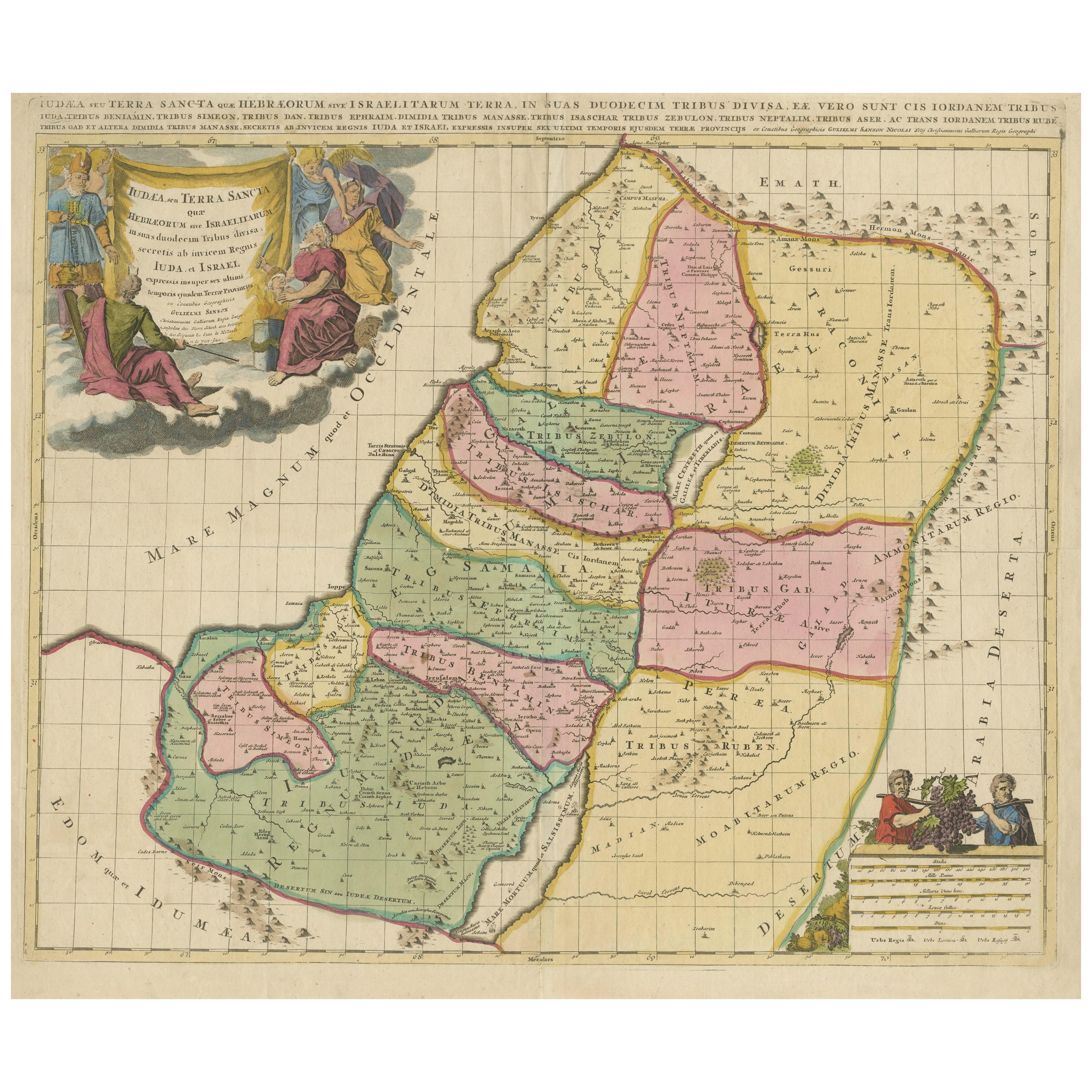
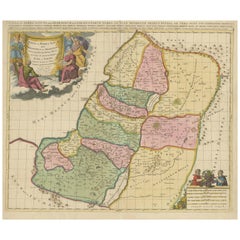
Antique French Map of the Holy Land, Twelve Tribes of Israel, c.1750
1.100 €Einschließlich MwSt.
Angaben zum Objekt
Antique Holy Land Map, Twelve Tribes of Israel – Robert de Vaugondy, c.1750
Description
This finely engraved and hand-colored map depicts Judea, or the Holy Land, divided according to the Twelve Tribes of Israel, each territory carefully delineated with colored boundaries and identified by name. The composition reflects the scholarly French cartographic tradition of the mid-18th century, combining biblical geography with contemporary geographic knowledge in a visually balanced and highly legible format.
The map was produced in Paris around 1750 by Robert de Vaugondy, one of the most respected mapmakers of the Enlightenment period. Vaugondy’s work is known for its precision, clarity, and elegant ornamentation, qualities that made his maps popular with scholars, collectors, and institutions throughout Europe.
An inset map in the upper left shows Canaan, or the Promised Land, extending into Phoenicia and Syria, with the northeastern reaches of Egypt also indicated. Geographic features such as coastlines, rivers, mountain ranges, deserts, and settlements are carefully rendered, while the Mediterranean Sea and surrounding regions are clearly labeled. The decorative cartouche adds refinement without overwhelming the map’s academic character, making it equally suitable for a study, library, or refined interior.
Maps of the Holy Land from this period remain highly sought after for their historical, religious, and decorative significance. This example offers a particularly appealing balance of scholarship and visual presence, with strong original hand coloring enhancing both the tribal divisions and the overall composition.
Condition report
Good antique condition. Original central fold as issued. Light age toning and minor handling marks consistent with 18th-century paper. No losses or major defects. Overall well-preserved with strong clarity of engraving and color.
Framing tips
This map presents beautifully with a muted walnut or dark ebonized frame paired with an off-white or parchment mat. For a more traditional look, an antique gold frame with a narrow profile will subtly echo the cartouche while maintaining a refined, scholarly appearance.
Technique: Engraving with original hand color
Maker: Robert de Vaugondy, Paris, circa 1750
- Maße:Höhe: 51 cm (20,08 in)Breite: 68 cm (26,78 in)Tiefe: 0,2 mm (0,01 in)
- Materialien und Methoden:Papier,Graviert
- Herkunftsort:
- Zeitalter:
- Herstellungsjahr:circa 1750
- Zustand:Good antique condition. Original central fold as issued. Light age toning and minor handling marks consistent with 18th-century paper. No losses or major defects. Overall well-preserved with strong clarity of engraving and color.
- Anbieterstandort:Langweer, NL
- Referenznummer:Anbieter*in: BG-14152-21stDibs: LU3054348066812
Anbieterinformationen
5,0
Anerkannte Anbieter*innen
Diese renommierten Anbieter*innen sind führend in der Branche und repräsentieren die höchste Klasse in Sachen Qualität und Design.
Platin-Anbieter*in
Premium-Anbieter*innen mit einer Bewertung über 4,7 und 24 Stunden Reaktionszeit
Gründungsjahr 2009
1stDibs-Anbieter*in seit 2017
2.813 Verkäufe auf 1stDibs
Typische Antwortzeit: 1 Stunde
- VersandAngebot wird abgerufen …Versand von: Langweer, Niederlande
- Rückgabebedingungen
Einige Inhalte dieser Seite wurden automatisch übersetzt. Daher kann 1stDibs nicht die Richtigkeit der Übersetzungen garantieren. Englisch ist die Standardsprache dieser Website.
Mehr von diesem*dieser Anbieter*in
Alle anzeigenHoly Land Map of the Twelve Tribes of Israel, After Sanson, Paris c.1798
Holy Land, Twelve Tribes of Israel – After Nicolas Sanson, De Vaugondy / Delamarche, c.1798
Description:
Holy Land. De Vaugondy (G. R.), Carte de la Terre des Hébreux ou Israélites,...
Kategorie
Antik, Spätes 18. Jahrhundert, Französisch, Landkarten
Materialien
Papier

Antique Holy Land Map, Twelve Tribes of Israel – Covens
Mortier, c.1700
Antique Holy Land Map, Twelve Tribes of Israel – Covens
Mortier, c.1700
Description:
This finely engraved early 18th-century map depicts the Holy Land divided according to the...
Kategorie
Antik, Frühes 18. Jahrhundert, Französisch, Landkarten
Materialien
Papier

Hochdetaillierte antike Karte des Heiligen Landes mit 12 Israeler Stämmen, um 1720
Antike Karte mit dem Titel 'Heylige Land verdeeld in de Twaalf Stammen Israels (...)'.
Sehr detaillierte Karte des Heiligen Landes, aufgeteilt in die 12 Stämme Israels. Mit schön...
Kategorie
Antik, 1720er, Landkarten
Materialien
Papier

384 € Verkaufspreis
20 % Rabatt
Kostenloser Versand
Antike Karte des Heiligen Landes von Van Luchtenburg, um 1720
Antike Karte mit dem Titel 'Heylige Land verdeeld in de Twaalf Stammen Israels (..) Sehr detaillierte Karte des Heiligen Landes, aufgeteilt in die 12 Stämme Israels. Mit schöner groß...
Kategorie
Antik, 18. Jahrhundert, Landkarten
Materialien
Papier

1718 Heilige Landkarte – Zwölf Stammesgruppen, sechs Provinzen, handkolorierte, antike Karte
Titel: Terra Sancta in XII olim Tribus nunc VI Provincias Dispertita
Kartograph: Christophe Weigel der Ältere (1654-1725)
Herausgeber: Johann Ernst Adelbulner
Ort und Jahr der ...
Kategorie
Antik, 1710er, Deutsch, Landkarten
Materialien
Papier

Judaea or Terra Sancta, Twelve Tribes of Israel – Sanson Map, c.1680
Judaea or Terra Sancta, Twelve Tribes of Israel – Sanson Map, c.1680
This antique map depicts Judaea or the Holy Land divided among the Twelve Tribes of Israel, based on biblical ge...
Kategorie
Antik, Spätes 17. Jahrhundert, Niederländisch, Landkarten
Materialien
Papier
Das könnte Ihnen auch gefallen
Map Holy Land La Terre Sainte gravierte van Loon veröffentlicht N de Fer 1703 Französisch, Heiliges Land
La Terre Sainte, Das Heilige Land, Tiree Des Memoires De M.De.La Rue. Par N. de Fer. Geographe de Sa Majeste Catoliq et de Monseigneur le Dauphin. Avec Privil du Roi 1703
Detailli...
Kategorie
Antik, Anfang 1700, Französisch, Louis XIV., Landkarten
Materialien
Papier

Li Governi di Borgogna – Karte aus der Antike – 1777
Li Governi di Borgogna ist eine Original-Radierung in Schwarz-Weiß auf Papier, gedruckt von Antonio Zatta in Venedig, 1777.
Originaltitel: Li Governi di Borgogna della Franca Contea...
Kategorie
1770er, Moderne, Landschaftsdrucke
Materialien
Radierung

Französische Region der Normandie: Eine handkolorierte Karte aus dem 17. Jahrhundert von Sanson und Jaillot
Von Nicolas Sanson
Diese große handkolorierte Karte mit dem Titel "Le Duché et Gouvernement de Normandie divisée en Haute et Basse Normandie en divers Pays; et par evêchez, avec le Gouvernement General...
Kategorie
Antik, 1690er, Französisch, Landkarten
Materialien
Papier

1.646 € Verkaufspreis
20 % Rabatt
Südgriechisches Griechenland: Eine große handkolorierte Karte des 17. Jahrhunderts von Sanson und Jaillot
Von Nicholas Sanson d
Abbeville
Diese große original handkolorierte Kupferstichkarte von Südgriechenland und der Halbinsel Peloponnes mit dem Titel "La Moree Et Les Isles De Zante, Cefalonie, Ste. Marie, Cerigo & C...
Kategorie
1690er, Landschaftsdrucke
Materialien
Gravur

1657 Janssonius Karte von Vermandois und Cappelle, Ric. A-004
1657 Janssonius-Karte von
Vermandois und Cappelle
Ric.a004
Beschreibung: Antike Karte von Frankreich mit dem Titel "Descriptio Veromanduorum - Gouvernement de la Cappelle". Zw...
Kategorie
Antik, 17. Jahrhundert, Unbekannt, Landkarten
Materialien
Papier

Portugal: Eine große handkolorierte Karte aus dem 17. Jahrhundert von Sanson und Jaillot
Von Nicholas Sanson d
Abbeville
Diese große handkolorierte Karte mit dem Titel "Le Royaume de Portugal et des Algarves Divisee en see Archeveches, Eveches et Territoires Par le Sr Sanson" wurde ursprünglich von Nic...
Kategorie
1690er, Landschaftsdrucke
Materialien
Gravur

1.507 € Verkaufspreis
20 % Rabatt