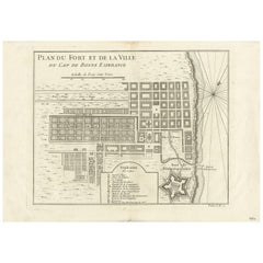
Objekte ähnlich wie Cape of Good Hope – Fort and City Plan, French Colonial Map, c.1765

Möchten Sie mehr Bilder oder Videos?
Zusätzliche Bilder oder Videos von dem*der Anbieter*in anfordern
1 von 9
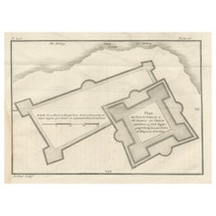
Cape of Good Hope – Fort and City Plan, French Colonial Map, c.1765
570 €Einschließlich MwSt.
Angaben zum Objekt
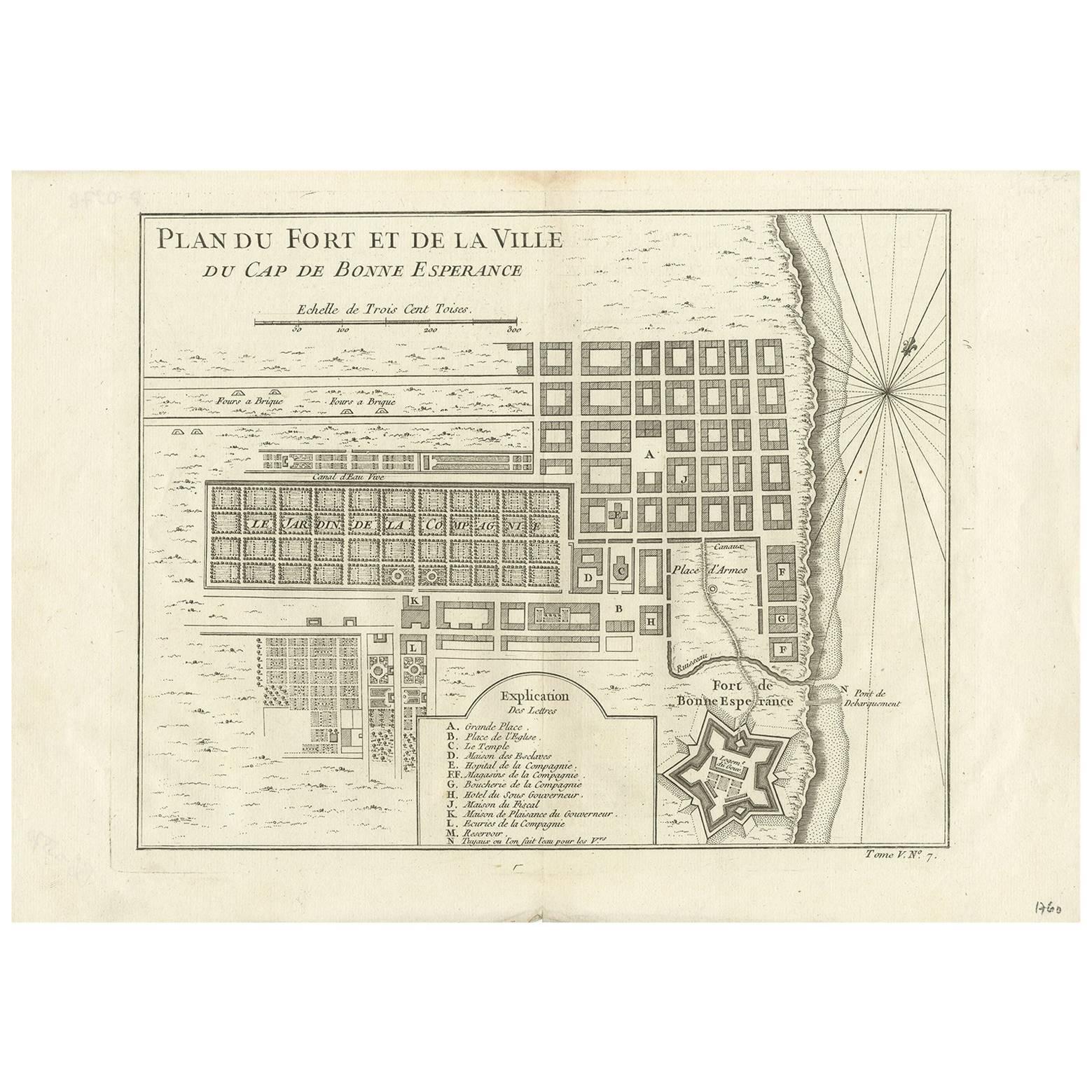
Cape of Good Hope – Fort and City Plan, French Colonial Map, c.1765
This detailed French plan depicts the fortifications and urban layout of the Cape of Good Hope, one of the most strategically important colonial ports of the 18th century. Titled “Plan du Fort et de la Ville du Cap de Bonne Esperance,” the map was engraved under the direction of Jacques-Nicolas Bellin, Hydrographer to the French King, and published in Paris circa 1760–1770 as part of his official hydrographic work for the Dépôt des cartes et plans de la Marine.
The plan shows the Cape as a carefully organized colonial settlement, with its rectilinear street grid, public squares, gardens, canals, and key administrative buildings clearly delineated. The famous star-shaped Fort de Bonne Esperance is rendered in precise detail, reflecting contemporary military engineering principles and the defensive importance of the site for European powers navigating between the Atlantic and Indian Oceans.
Bellin’s plan combines urban cartography with maritime intelligence. The shoreline, anchorage, landing points, and compass rose emphasize the Cape’s role as a critical resupply and control point on global trade routes linking Europe, Africa, and Asia. The inclusion of an explanatory legend identifying principal buildings and functions underscores the map’s practical and administrative purpose.
Although the Cape was under Dutch control at the time, French naval and commercial interests made accurate knowledge of the settlement essential. Bellin’s work reflects the broader European competition for influence along African coasts and sea routes during the mid-18th century. The restrained hand coloring, clear engraving, and balanced composition make this both a historically important document and a visually compelling display piece.
This plan is especially appealing to collectors of colonial urban history, fortification plans, and South African cartography, and it serves as an ideal counterpart to broader regional maps of East and Southern Africa.
Condition report
Good condition overall. Central vertical fold as issued. Light age toning consistent with period. Minor scattered spots and light surface marks. Original hand coloring. Plate mark visible. Margins intact.
Framing tips
A generous off-white or light sand-colored mat highlights the crisp geometry of the city grid and fort. A medium to dark wood frame complements the hand coloring and gives the piece a refined, architectural presence. Particularly effective as a focal work or paired with regional African maps.
Technique: Copper engraving with contemporary hand color
Maker: Jacques-Nicolas Bellin, France, c.1765
- Maße:Höhe: 25,5 cm (10,04 in)Breite: 39,7 cm (15,63 in)Tiefe: 0,2 mm (0,01 in)
- Materialien und Methoden:Papier,Graviert
- Herkunftsort:
- Zeitalter:1760–1769
- Herstellungsjahr:circa 1765
- Zustand:Good condition overall. Central vertical fold as issued. Light age toning consistent with period. Minor scattered spots and light surface marks. Original hand coloring. Plate mark visible. Margins intact.
- Anbieterstandort:Langweer, NL
- Referenznummer:Anbieter*in: BG-14128-51stDibs: LU3054348016892
Anbieterinformationen
5,0
Anerkannte Anbieter*innen
Diese renommierten Anbieter*innen sind führend in der Branche und repräsentieren die höchste Klasse in Sachen Qualität und Design.
Platin-Anbieter*in
Premium-Anbieter*innen mit einer Bewertung über 4,7 und 24 Stunden Reaktionszeit
Gründungsjahr 2009
1stDibs-Anbieter*in seit 2017
2.813 Verkäufe auf 1stDibs
Typische Antwortzeit: 1 Stunde
- VersandAngebot wird abgerufen …Versand von: Langweer, Niederlande
- Rückgabebedingungen
Einige Inhalte dieser Seite wurden automatisch übersetzt. Daher kann 1stDibs nicht die Richtigkeit der Übersetzungen garantieren. Englisch ist die Standardsprache dieser Website.
Mehr von diesem*dieser Anbieter*in
Alle anzeigenAntike Karte des Kapes der guten Hoffnung von J.N. Bellin, 1748
Früher Plan vom Kap der Guten Hoffnung, einschließlich eines Stadtplans und Abbildungen der Festungsanlagen. Diese Karte stammt aus Tome V von Abbe Prevosts Histoire generale du voya...
Kategorie
Antik, Mitte des 18. Jahrhunderts, Landkarten
Materialien
Papier
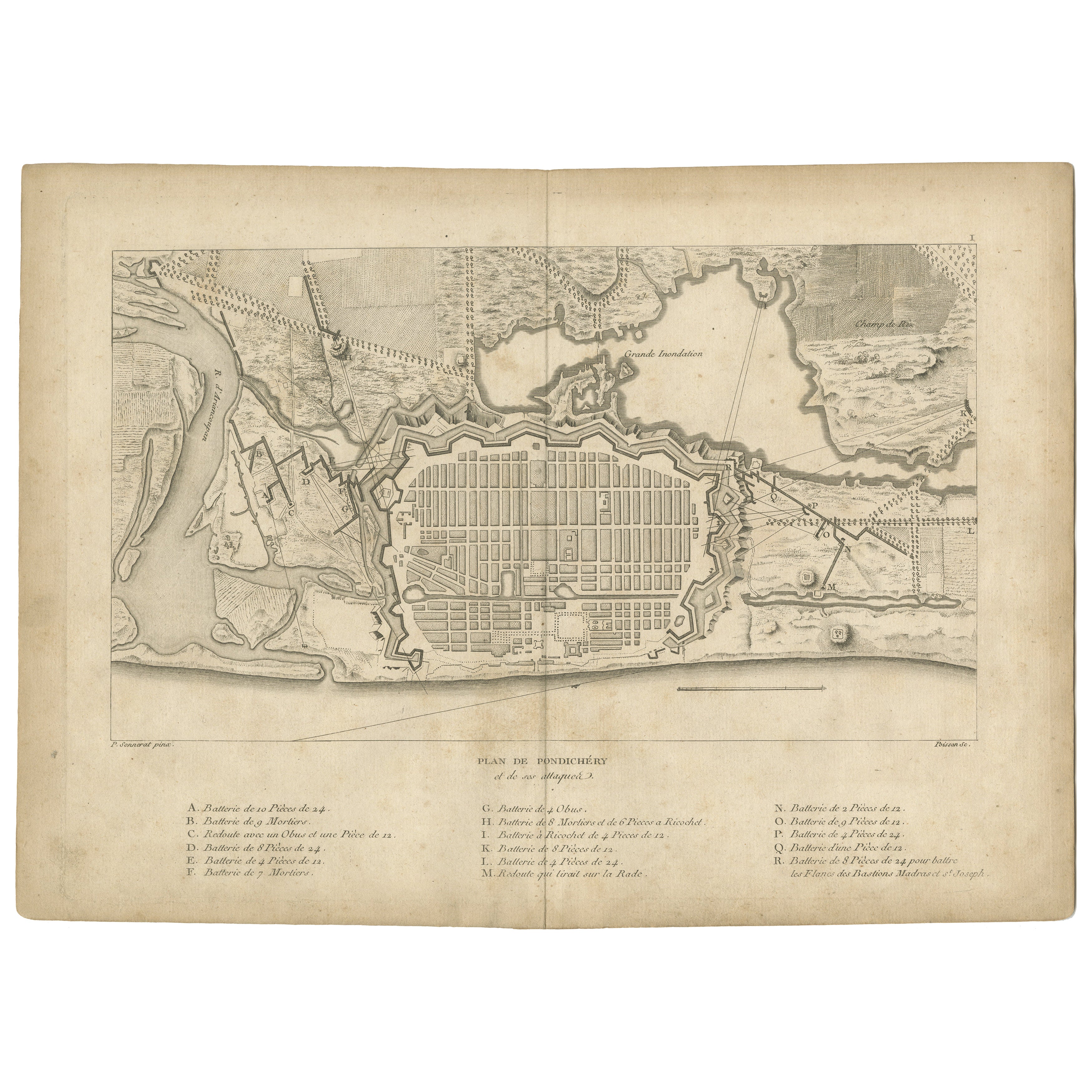
Plan der Festungsanlagen und Angriffe von Pondicherry, Frankreich, um 1750
Plan der Festungsanlagen und Angriffe von Pondicherry, Frankreich, um 1750
Diese fein gestochene Karte zeigt die befestigte Stadt Pondicherry und trägt den Titel "Plan de Pondichéry...
Kategorie
Antik, Mitte des 18. Jahrhunderts, Französisch, Landkarten
Materialien
Papier
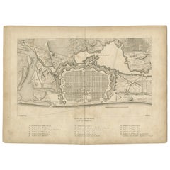
Antike Karte der Umgebung von Cap-Français, Saint-Domingue, ca. 1760
Antike Karte der Umgebung von Cap-Français, Saint-Domingue, ca. 1760
Dieser detaillierte Kupferstich aus dem 18. Jahrhundert mit dem Titel Carte des Environs du Cap Français et des ...
Kategorie
Antik, Frühes 18. Jahrhundert, Französisch, Landkarten
Materialien
Papier
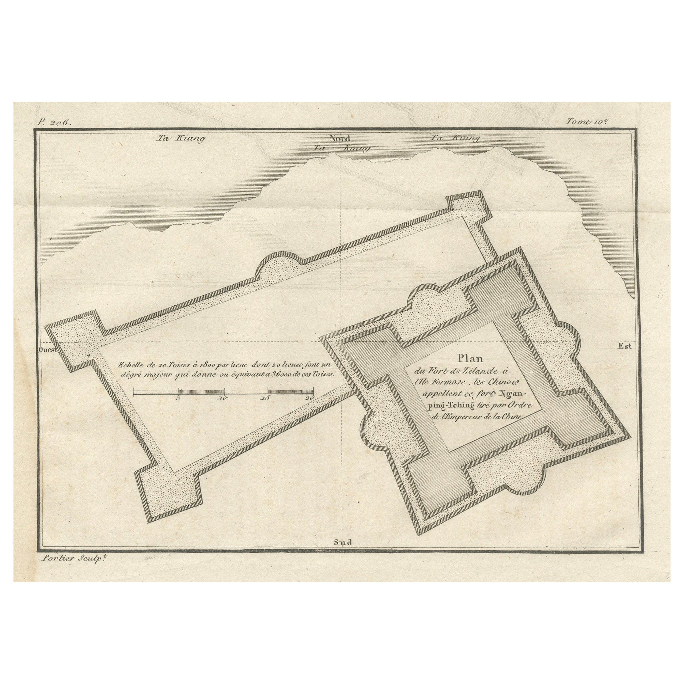
Plan des niederländischen Forts in Formosa - Antique French Jesuit Engraving, ca.1790
Plan des niederländischen Forts in Formosa - Antiker französischer Jesuitenstich von Portier, um 1790
Dieser antike französische Stich von Portier, der um 1790 entstand, zeigt einen...
Kategorie
Antik, Spätes 18. Jahrhundert, Französisch, Landkarten
Materialien
Papier
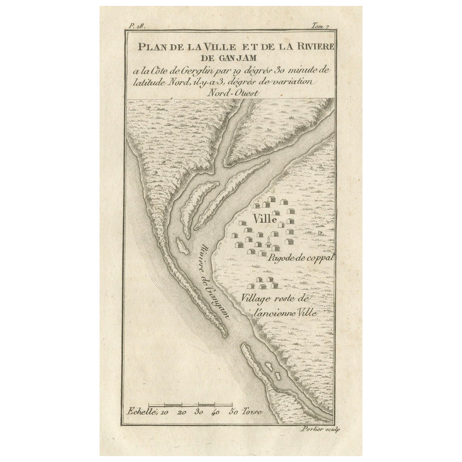
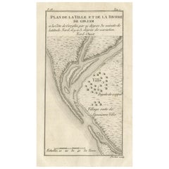
Plan der Townes und des Flusses von Ganjam, Indien - Antique French Map von Portier 1790
Plan der Townes und des Flusses von Ganjam, Indien - Antike französische Karte von Portier, um 1790
Dieser antike französische Stich zeigt einen detaillierten Plan der Stadt und des...
Kategorie
Antik, Spätes 18. Jahrhundert, Französisch, Landkarten
Materialien
Papier
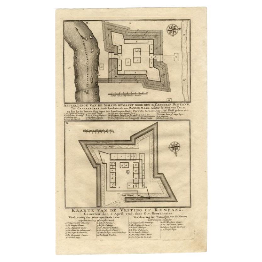
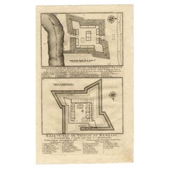
Antike Karte der Burg von Kapitän E. Bintang von Valentijn, 1726
Antiker Druck mit dem Titel 'Kaarte van de Schans gemaakt door den E. Capitein Bintang. Kaarte van de Vesting op Rembang' Ein Plan des von Kapitän E. Bintang errichteten Forts in der...
Kategorie
Antik, 18. Jahrhundert, Landkarten
Materialien
Papier
Das könnte Ihnen auch gefallen
Original antike Karte oder Stadtplan von Genf, Schweiz. CIRCA 1835
Schöne Karte von Genf
Gezeichnet und gestochen von J. Dower
Herausgegeben von Orr & Smith. C.1835
Ungerahmt.
Kostenloser Versand
Kategorie
Antik, 1830er, Englisch, Landkarten
Materialien
Papier

Kartengravur aus dem 18. Jahrhundert – Plan der Werke der Stadt Messina, Sizilien
Eine Karte von Messina, einer Hafenstadt im Nordosten Siziliens. Bezeichnet mit dem Titel in der Platte auf den unteren Rand, "Plan der Werke der Stadt Messina, einer der stärksten u...
Kategorie
18. Jahrhundert, Mehr Drucke
Materialien
Gravur

247 € Verkaufspreis
20 % Rabatt
Kartengravur aus dem 18. Jahrhundert – Newport, eine starke Hafenstadt in Flandern
Eine Karte von Nieuwpoort, anglisiert zu 'Newport', in Nordbelgien. Im oberen Viertel befindet sich ein Panorama, das die wichtigsten Sehenswürdigkeiten zeigt. Unten sehen Sie einen ...
Kategorie
18. Jahrhundert, Mehr Drucke
Materialien
Gravur

233 € Verkaufspreis
20 % Rabatt
Plan von Port Siagi – Radierung von Joseph Roux – 1795
Der Plan von Port Siagi ist eine farbige Radierung von Joseph Roux aus dem Jahr 1795.
Der Titel oben " Plan du Port Siagi"
Passepartout inklusive: 34 x 49
Das Kunstwerk ist von Ha...
Kategorie
1790er, Moderne, Figurative Drucke
Materialien
Radierung

Antike antike 1765 klappbare Landkarte von Frankreich, Bordeau usw.
Route du Carosse de Bordeaux, part de Paris tous les Mardis a 11 matin. a et pafse 1765 ist eine umfassende Karte mit zwei Routen durch das Weinland Frankreichs, die in Paris begin...
Kategorie
1760er, Sonstige Kunststile, Landschaftsdrucke
Materialien
Radierung

Cadiz-Insel: Eine gerahmte, handkolorierte Karte aus Blaeu
s Atlas Major aus dem 17. Jahrhundert
Von Joan (Johannes) Blaeu
Dies ist eine handkolorierte Karte aus dem 17. Jahrhundert mit dem Titel "Insula Gaditana Isla de Cadiz" aus dem Atlas Maior von Johannes (Joan) Blaeu, der 1662 in Amsterdam veröffen...
Kategorie
Mitte 17. Jahrhundert, Alte Meister, Landschaftsdrucke
Materialien
Gravur
