Objekte ähnlich wie East African Coast – French Map by Bellin, Zanzibar to Arabia, 1740

Möchten Sie mehr Bilder oder Videos?
Zusätzliche Bilder oder Videos von dem*der Anbieter*in anfordern
1 von 9
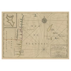
East African Coast – French Map by Bellin, Zanzibar to Arabia, 1740
440 €Einschließlich MwSt.
Angaben zum Objekt
East African Coast – French Map by Bellin, Zanzibar to Arabia, 1740
This important French map depicts the eastern coast of Africa from Mozambique and Zanzibar northward to the Horn of Africa and the Arabian Peninsula. Titled “Carte de la Coste Orientale d’Afrique,” the map was engraved under the direction of Jacques-Nicolas Bellin, Hydrographer to the French King, and published in Paris in 1740 by order of the Comte de Maurepas.
The chart was drawn from Bellin’s larger map of the Indian Ocean and represents one of the earliest systematic French attempts to chart the East African coastline with consistency and comparative accuracy. It covers a vast geographic area, including Mozambique, Zanzibar, Mombasa, the Somali coast, the Red Sea entrance, southern Arabia, and the islands of Socotra and the Comoros, including Anjouan.
Bellin’s engraving emphasizes coastal continuity and navigational clarity. Key ports, capes, islands, and trading centers are carefully named, reflecting the importance of this coastline within Indian Ocean trade networks linking East Africa, Arabia, India, and Europe. Latitude lines, a longitudinal grid, and a finely engraved compass rose reinforce the map’s scientific and navigational intent.
The decorative cartouche, engraved in a restrained Rococo style, balances elegance with authority and identifies the map as an officially sanctioned French hydrographic production. Bellin’s work is known for its clarity and reliability, and his African coastal maps are increasingly sought after due to their historical significance and strong visual appeal.
This map offers a broad contextual view that complements more localized charts of Mozambique and the Comoros, making it particularly attractive to collectors interested in French colonial cartography, Indian Ocean trade history, or early European mapping of Africa.
Condition report
Good condition overall. Light age toning consistent with period. Minor scattered spots and a few small stains. Original hand coloring. Plate mark visible. Margins intact.
Framing tips
A warm ivory or light sand-colored mat works well with the aged paper tone and colored coastline. A medium to dark wood frame enhances the cartouche and compass rose without overpowering the composition. This map displays beautifully as a centerpiece or as part of a coordinated East African wall arrangement.
Technique: Copper engraving with contemporary hand color
Maker: Jacques-Nicolas Bellin, France, 1740
- Maße:Höhe: 26,3 cm (10,36 in)Breite: 24 cm (9,45 in)Tiefe: 0,2 mm (0,01 in)
- Materialien und Methoden:Papier,Graviert
- Herkunftsort:
- Zeitalter:1740-1749
- Herstellungsjahr:circa 1740
- Zustand:Good condition overall. Light age toning consistent with period. Minor scattered spots and a few small stains. Original hand coloring. Plate mark visible. Margins intact.
- Anbieterstandort:Langweer, NL
- Referenznummer:Anbieter*in: BG-14128-31stDibs: LU3054348016712
Anbieterinformationen
5,0
Anerkannte Anbieter*innen
Diese renommierten Anbieter*innen sind führend in der Branche und repräsentieren die höchste Klasse in Sachen Qualität und Design.
Platin-Anbieter*in
Premium-Anbieter*innen mit einer Bewertung über 4,7 und 24 Stunden Reaktionszeit
Gründungsjahr 2009
1stDibs-Anbieter*in seit 2017
2.813 Verkäufe auf 1stDibs
Typische Antwortzeit: 1 Stunde
- VersandAngebot wird abgerufen …Versand von: Langweer, Niederlande
- Rückgabebedingungen
Einige Inhalte dieser Seite wurden automatisch übersetzt. Daher kann 1stDibs nicht die Richtigkeit der Übersetzungen garantieren. Englisch ist die Standardsprache dieser Website.
Mehr von diesem*dieser Anbieter*in
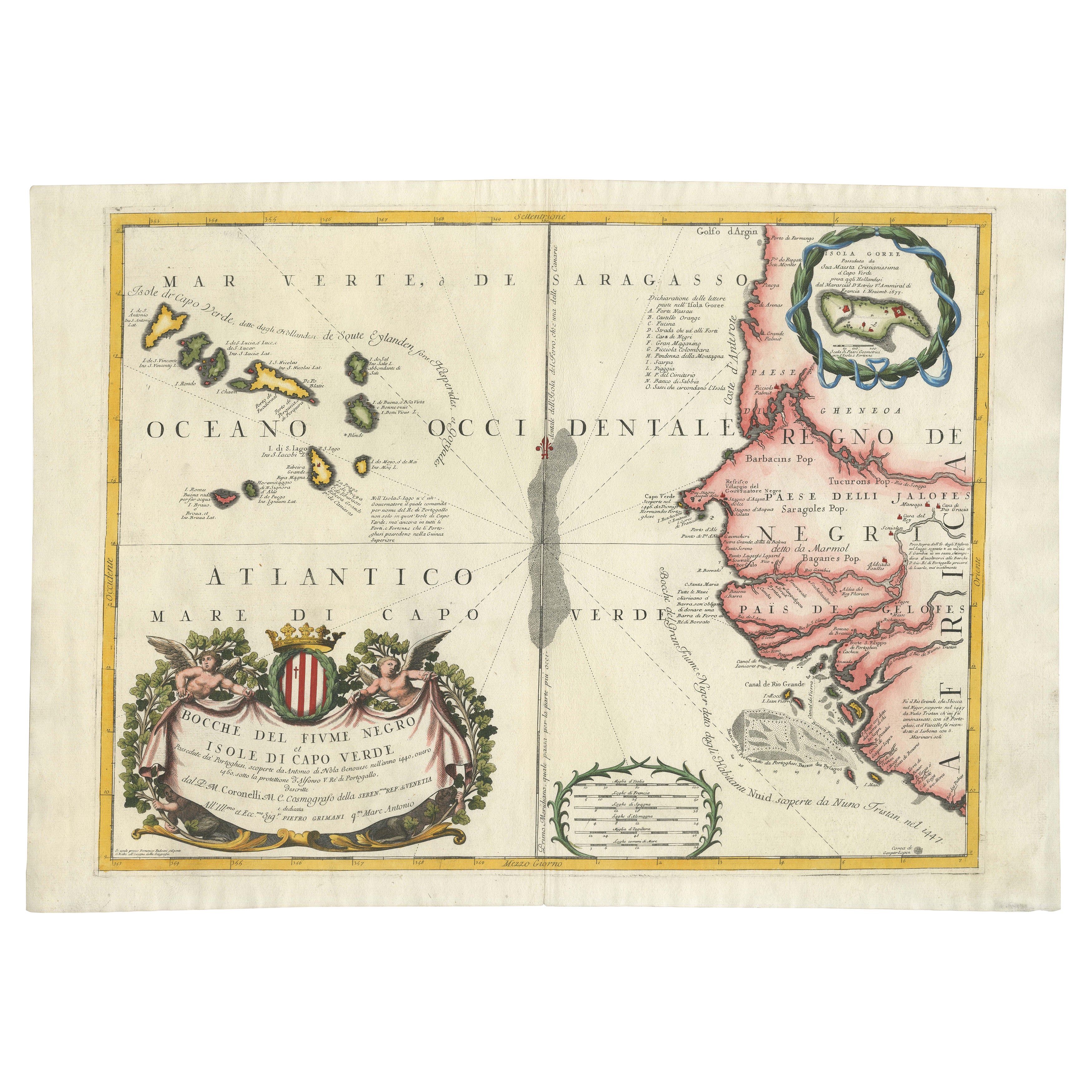
Alle anzeigenMap of Cape Verde and the Mouth of the River Niger by Coronelli, 1691
Map of Cape Verde and the Mouth of the River Niger by Coronelli, 1691
This finely engraved map, titled "Bocche del Fiume Negro et Isole di Capo Verde," was created in 1691 by Vincen...
Kategorie
Antik, Spätes 17. Jahrhundert, Landkarten
Materialien
Papier
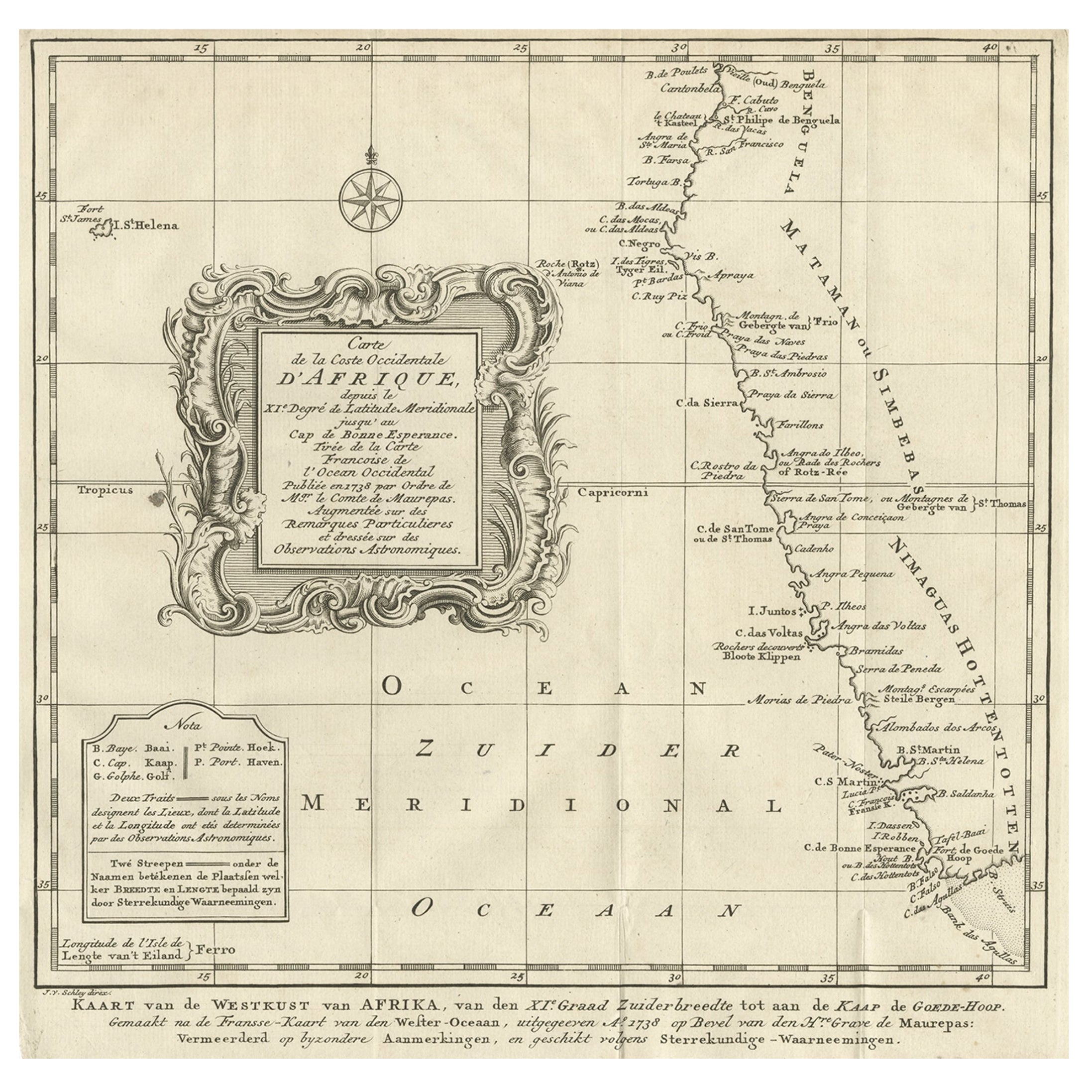
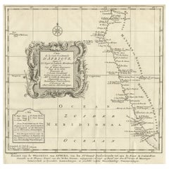
Niederländische antike Karte der Westküste Afrikas, bis zum Kap von Good Hope, 1747
Antike Karte der Küste Afrikas mit dem Titel 'Kaart van de West Kust van Afrika (..)'.
Karte der Westküste Afrikas, von 11 Grad südlicher Breite bis zum Kap der Guten Hoffnung. D...
Kategorie
Antik, 1740er, Landkarten
Materialien
Papier
312 € Verkaufspreis
20 % Rabatt
Kostenloser Versand
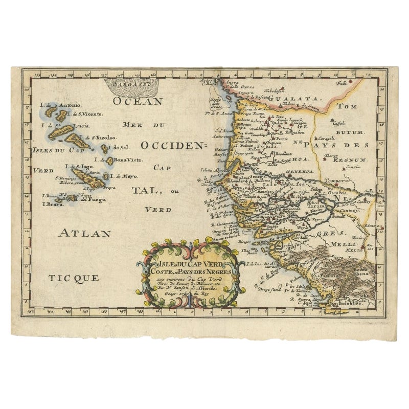
Antike Karte der westafrikanischen Küste und der Inseln Kap Verde, um 1680
Antike Karte Afrika mit dem Titel 'Isles du Cap Verd Coste et Pays des Negres'. Antike Karte der Küste Afrikas und der Kapverdischen Inseln.
Artisten und Graveure: Nicholas Sanson ...
Kategorie
Antik, 17. Jahrhundert, Landkarten
Materialien
Papier

288 € Verkaufspreis
20 % Rabatt
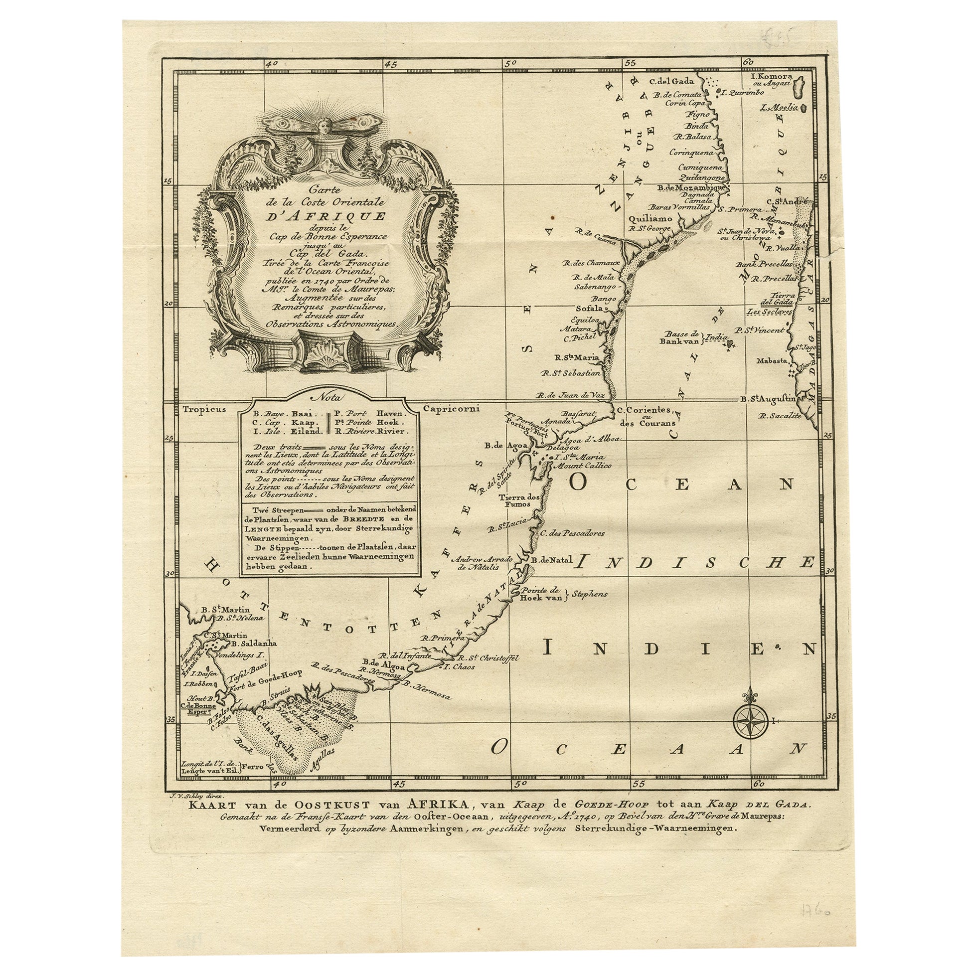
Detaillierte antike Karte der Ostküste Afrikas mit Details, 1747
Antike Karte mit dem Titel 'Carte de la coste Orientale d'Afrique - Kaart van de Oostkust van Afrika'.
Original antike Karte der Ostküste Afrikas. Reicht vom Kap der Guten Hoffnu...
Kategorie
Antik, 1740er, Landkarten
Materialien
Papier

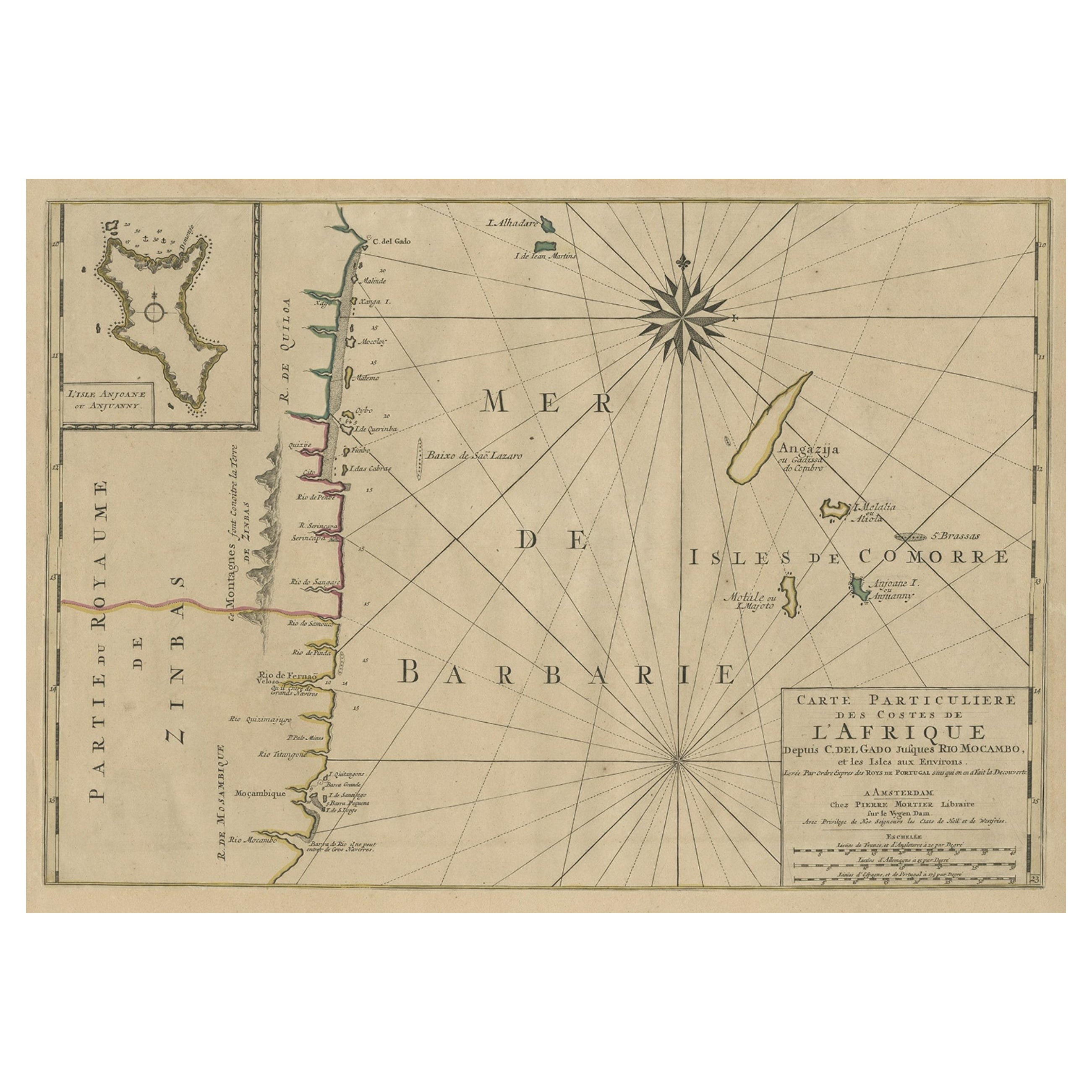
Karte der Küste von Mosambik und Tansanien mit eingelegter Karte der Insel Anjouan, ca. 1700
Antike Karte mit dem Titel 'Carte particuliere des Costes de l'Afrique'.
Zeigt die Küsten von Mosambik und Tansania. Mit einer beigefügten Karte der Insel Anjouan.
Künstler un...
Kategorie
Antik, Anfang 1700, Landkarten
Materialien
Papier
512 € Verkaufspreis
20 % Rabatt
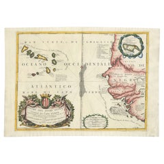
Antike Karte der Inseln Kap Verde und eines Teils des Senegal, Westafrika, 1690
Antike Karte mit dem Titel "Bocche del Fivme Negro et Isole di Capo Verde". Schöne doppelseitige Karte der Kapverdischen Inseln und eines Teils der Küste Senegals, mit großer dekorat...
Kategorie
Antik, 17. Jahrhundert, Italienisch, Landkarten
Materialien
Papier

Das könnte Ihnen auch gefallen
Westafrikanische Westküste, Guinea und Sierra Leone: Eine Karte aus dem 18. Jahrhundert von Bellin
Von Jacques-Nicolas Bellin
Die Kupferstichkarte von Jacques Bellin mit dem Titel "Partie de la Coste de Guinee Dupuis la Riviere de Sierra Leona Jusquau Cap das Palmas", die die Küste von Guinea und Sierra Leo...
Kategorie
Antik, Mitte des 18. Jahrhunderts, Französisch, Landkarten
Materialien
Papier

398 € Verkaufspreis
20 % Rabatt
Bellin Karte der Westküste Afrikas, 18. Jahrhundert; Guinea und Sierra Leone
Jacques Bellins Kupferstichkarte mit dem Titel "Partie de la Coste de Guinee Dupuis la Riviere de Sierra Leona Jusquau Cap das Palmas", die die Küste von Guinea und Sierra Leone in W...
Kategorie
1740er, Alte Meister, Landschaftsdrucke
Materialien
Gravur

398 € Verkaufspreis
20 % Rabatt
Afrika: Eine große handkolorierte Karte aus dem 17. Jahrhundert von Sanson und Jaillot
Von Nicolas Sanson
Diese große original handkolorierte Kupferstichkarte von Afrika mit dem Titel "L'Afrique divisee suivant l'estendue de ses principales parties ou sont distingues les uns des autres, ...
Kategorie
Antik, 1690er, Französisch, Landkarten
Materialien
Papier

1.507 € Verkaufspreis
20 % Rabatt
Afrika: Eine große handkolorierte Karte aus dem 17. Jahrhundert von Sanson und Jaillot
Von Nicholas Sanson d
Abbeville
Diese große original handkolorierte Kupferstichkarte von Afrika mit dem Titel "L'Afrique divisee suivant l'estendue de ses principales parties ou sont distingues les uns des autres, ...
Kategorie
1690er, Landschaftsdrucke
Materialien
Gravur

1.507 € Verkaufspreis
20 % Rabatt
Antike Karte – Mare Pacificum – Radierung von Johannes Janssonius – 1650er Jahre
Von Johannes Janssonius
Mare Pacificum ist eine antike Karte aus dem Jahr 1650 von Johannes Janssonius (1588-1664).
Die Karte ist handkolorierte Radierung, mit Coeval Aquarellang.
Guter Zustand mit leicht...
Kategorie
1650er, Moderne, Figurative Drucke
Materialien
Radierung

""Africa Vetus"": eine handkolorierte Karte von Sanson aus dem 17. Jahrhundert
Von Nicolas Sanson
Diese originale handkolorierte Kupferstichkarte von Afrika mit dem Titel "Africa Vetus, Nicolai Sanson Christianiss Galliar Regis Geographi" wurde ursprünglich von Nicholas Sanson d'...
Kategorie
Antik, Spätes 17. Jahrhundert, Französisch, Landkarten
Materialien
Papier

952 € Verkaufspreis
20 % Rabatt