Objekte ähnlich wie Egypt
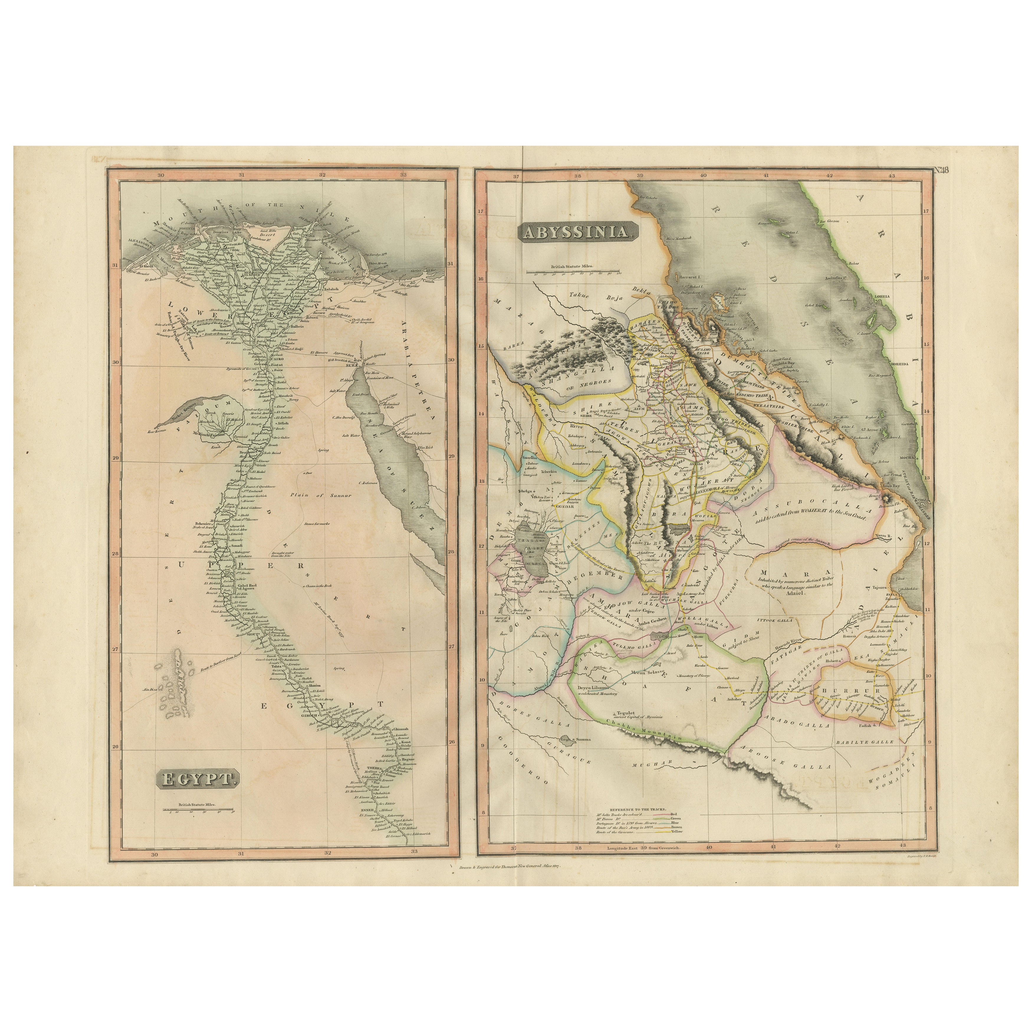
Abyssinia – Original Nile Valley and Horn of Africa Maps, c.1817


Möchten Sie mehr Bilder oder Videos?
Zusätzliche Bilder oder Videos von dem*der Anbieter*in anfordern
1 von 9
Egypt
Abyssinia – Original Nile Valley and Horn of Africa Maps, c.1817
550 €Einschließlich MwSt.
Angaben zum Objekt
Egypt
Abyssinia – Nile Valley and Horn of Africa Maps, c.1817–1820
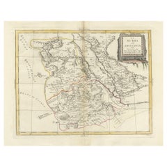
This refined early 19th-century map composition presents two related geographic views of Northeast Africa: Egypt with the full course of the Nile River, and Abyssinia (Ethiopia) with the Horn of Africa and Red Sea coast. Issued as companion maps circa 1817–1820, the sheets offer a clear and elegant overview of one of the most historically and geographically significant regions of Africa.
The Egypt map focuses on the Nile Valley from the Mediterranean Delta southward into Upper Egypt, emphasizing the river’s role as the organizing axis of settlement, agriculture, and civilization. Cities, river branches, desert regions, and historic sites are carefully engraved, creating a calm vertical composition that highlights the Nile’s uninterrupted flow through the landscape.
The Abyssinia map complements this view by presenting Ethiopia and the Horn of Africa, including the Red Sea coastline, inland mountain ranges, river systems, and regional boundaries. Political divisions are delicately outlined in contemporary hand color, distinguishing provinces and neighboring territories while maintaining visual clarity. Together, the two maps provide a balanced perspective on the Nile’s sources, surrounding highlands, and the broader Northeast African context.
The engraving style is clean and legible, characteristic of early 19th-century British atlas cartography, combining scientific precision with restrained elegance. Subtle hand coloring enhances coastlines and borders without overpowering the geography. When viewed together, the tall vertical Egypt map and the more compact Abyssinia map create a visually pleasing contrast that works exceptionally well for interior display.
This paired presentation appeals to collectors of African cartography, Nile history, and Ethiopian history, while also offering strong decorative value for both classic and contemporary interiors. Displayed side by side, the maps form a coherent and visually harmonious statement piece.
Condition report
Good condition overall. Central vertical folds as issued. Light age toning and some mild discoloration, more noticeable on the Egypt sheet. Minor scattered spots and light handling marks. Original outline hand color. Plate marks visible. Margins intact.
Framing tips
These maps work beautifully framed as a pair. Use matching off-white or light sand-colored mats to unify the presentation while allowing each map to breathe. Medium to dark wood frames or softly ebonized frames enhance the engraved detail and create a refined, gallery-ready appearance suitable for residential or hospitality interiors.
Technique: Copper engraving with contemporary outline hand color
Maker: British school (Thomson), c.1817
- Maße:Höhe: 54 cm (21,26 in)Breite: 71,5 cm (28,15 in)Tiefe: 0,2 mm (0,01 in)
- Materialien und Methoden:Papier,Graviert
- Herkunftsort:
- Zeitalter:
- Herstellungsjahr:circa 1817
- Zustand:Good condition overall. Vertical fold as issued. Light age toning and some mild discoloration, more noticeable on the Egypt sheet. Minor scattered spots and light handling marks. Original outline hand color. Plate marks visible. Margins intact.
- Anbieterstandort:Langweer, NL
- Referenznummer:Anbieter*in: BG-14128-121stDibs: LU3054348017432
Anbieterinformationen
5,0
Anerkannte Anbieter*innen
Diese renommierten Anbieter*innen sind führend in der Branche und repräsentieren die höchste Klasse in Sachen Qualität und Design.
Platin-Anbieter*in
Premium-Anbieter*innen mit einer Bewertung über 4,7 und 24 Stunden Reaktionszeit
Gründungsjahr 2009
1stDibs-Anbieter*in seit 2017
2.813 Verkäufe auf 1stDibs
Typische Antwortzeit: 1 Stunde
- VersandAngebot wird abgerufen …Versand von: Langweer, Niederlande
- Rückgabebedingungen
Einige Inhalte dieser Seite wurden automatisch übersetzt. Daher kann 1stDibs nicht die Richtigkeit der Übersetzungen garantieren. Englisch ist die Standardsprache dieser Website.
Mehr von diesem*dieser Anbieter*in
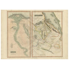
Alle anzeigenEgypt and Abyssinia – Nile Valley
Horn of Africa Maps, c.1817–1820
Egypt and Abyssinia – Nile Valley & Horn of Africa Maps, c.1817–1820
This refined early 19th-century paired map presents Egypt and Abyssinia (Ethiopia) as two complementary geograph...
Kategorie
Antik, 1810er, Britisch, Landkarten
Materialien
Papier
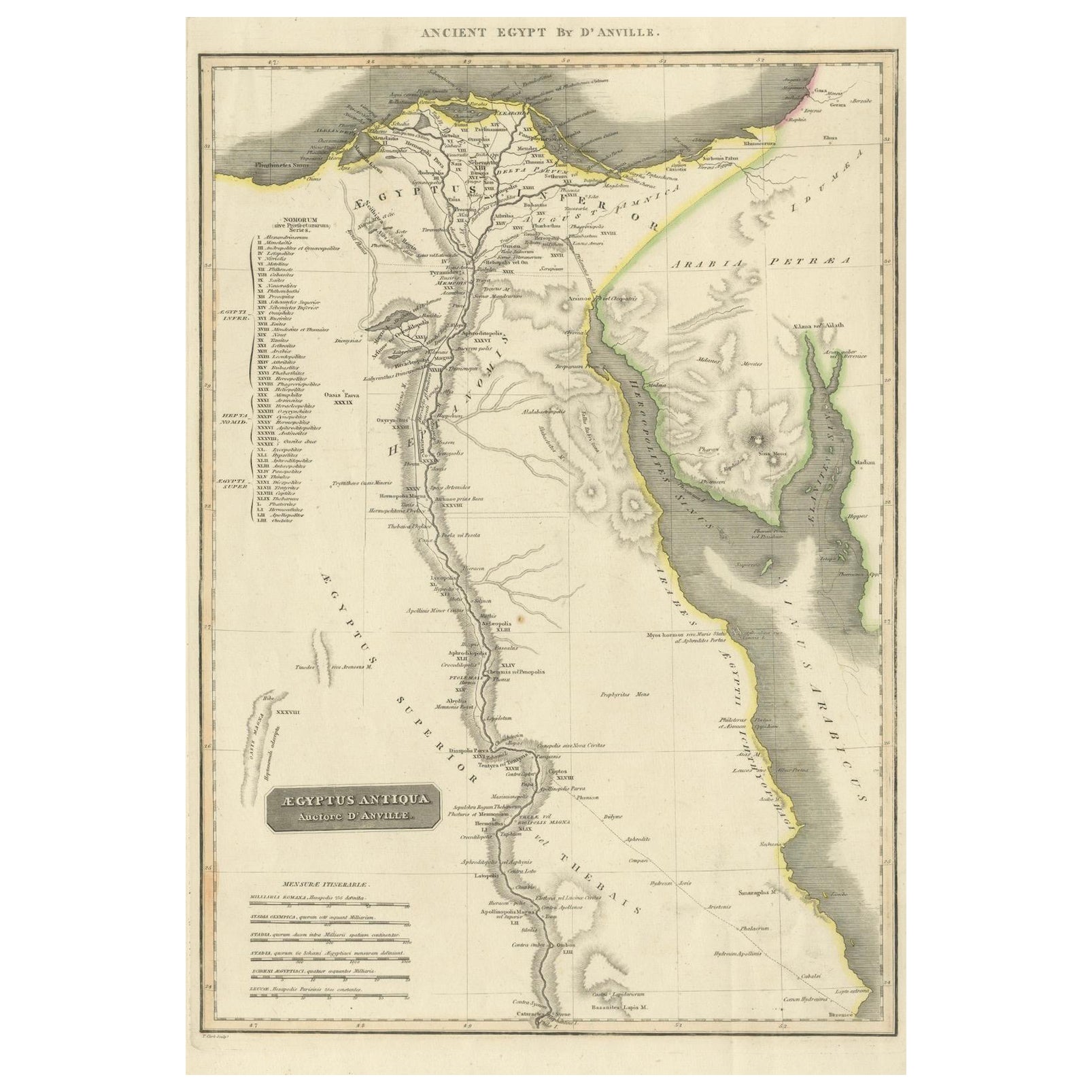
Ancient Egypt – Nile Valley Map by d’Anville, Classical Antiquity, c.1765
Ancient Egypt – Nile Valley Map by d’Anville, Classical Antiquity, c.1765
This finely engraved map depicts Ancient Egypt as understood through classical sources, extending along the...
Kategorie
Antik, 1760er, Französisch, Landkarten
Materialien
Papier
Antike Karte von Ägypten mit detailliertem Ausschnitt des Nildeltas, ca. 1799
Antike Karte von Ägypten mit detailliertem Ausschnitt des Nildeltas, ca. 1799
Diese fein gestochene antike Karte mit dem Titel Carte Physique et Politique de l'Égypte (Physikalische...
Kategorie
Antik, Anfang 1800, Französisch, Landkarten
Materialien
Papier

Egypt
Arabia Petraea – Large Nile Map, British Cartography, c.1815
Egypt & Arabia Petraea – Large Nile Map, British Cartography, c.1815
This impressive early 19th-century map depicts Egypt and Arabia Petraea with exceptional detail, extending from ...
Kategorie
Antik, 1810er, Britisch, Landkarten
Materialien
Papier

Große antike Karte des unteren Nile-Tals mit Ägypten und Nubia, 1842
Antike Karte mit dem Titel "Carte de l'Égypte, de la Nubie, de l'Abissinie". Karte von Ägypten, die das untere Niltal einschließlich Ägypten und Nubien abdeckt. Diese Karte stammt au...
Kategorie
Antik, 19. Jahrhundert, Landkarten
Materialien
Papier

Nubia and Abyssinia – Venetian Map of Northeast Africa, Zatta, 1784
Nubia and Abyssinia – Venetian Map of Northeast Africa, Zatta, 1784
This detailed late-18th-century map depicts Nubia and Abyssinia, covering large parts of present-day Sudan, Ethio...
Kategorie
Antik, 1780er, Italienisch, Landkarten
Materialien
Papier
Das könnte Ihnen auch gefallen
Afrika. Nord-Ost-Teil. Antike Atlas-Vintage-Karte
Der Jahrhundertatlas. Afrika. Nordöstlicher Teil
Originale antike Karte, 1903.
Inspektionskarte "Nildelta und Suezkanal".
Zentrale Falte wie ausgestellt. Name und Nummer der Karte ...
Kategorie
Frühes 20. Jahrhundert, Viktorianisch, Mehr Drucke
Materialien
Lithografie

Original Antike Karte von Afrika von Dower, um 1835
Schöne Karte von Afrika
Gezeichnet und gestochen von J. Dower
Herausgegeben von Orr & Smith. C.1835
Ungerahmt.
Kostenloser Versand
Kategorie
Antik, 1830er, Englisch, Landkarten
Materialien
Papier

Afrika. Nordwestlicher Teil. Antike Atlas-Vintage-Karte
Der Jahrhundertatlas. Afrika. Südlicher Teil
Originale antike Karte, 1903.
Zentrale Falte wie ausgestellt. Name und Nummer der Karte sind auf der Rückseite aufgedruckt.
Blatt 40cm ...
Kategorie
Frühes 20. Jahrhundert, Viktorianisch, Mehr Drucke
Materialien
Lithografie

Karte von Nubia und Abissinia – Original-Radierung von Antonio Zatta – 1784
Diese Karte von Nubien und Abissinien ist eine Radierung von Antonio Zatta aus dem Jahr 1784 in Venedig.
Der Erhaltungszustand des Kunstwerks ist gut, abgesehen von dem abgenutzten ...
Kategorie
1770er, Landschaftsdrucke
Materialien
Radierung

Antike italienische Karte von Asien aus dem Jahr 1803, einschließlich China Indoneseia Indien
Antike italienische Karte von Asien aus dem Jahr 1803, einschließlich China Indoneseia Indien
Sehr schöne Karte von Asien. 1803.
Zusätzliche Informationen:
Art: Karte
Land der Hers...
Kategorie
Antik, 19. Jahrhundert, Europäisch, Landkarten
Materialien
Papier

379 € Verkaufspreis
39 % Rabatt
Map of the Holy Land „Carte de la Syrie et de l
Egypte“ von Pierre M. Lapie
Von Pierre M. Lapie
Eine Karte des antiken Syriens und Ägyptens aus dem frühen 19. Jahrhundert mit dem Titel "Carte de la Syrie et de l'Egypte anciennes/dressée par M. Lapie, Colonel d'Etat Major, et M....
Kategorie
Antik, Frühes 19. Jahrhundert, Französisch, Landkarten
Materialien
Papier

536 € Verkaufspreis
20 % Rabatt