Objekte ähnlich wie Holy Land Map of the Twelve Tribes of Israel, After Sanson, Paris c.1798


Möchten Sie mehr Bilder oder Videos?
Zusätzliche Bilder oder Videos von dem*der Anbieter*in anfordern
1 von 9
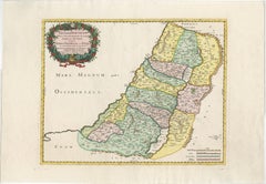
Holy Land Map of the Twelve Tribes of Israel, After Sanson, Paris c.1798
480 €Einschließlich MwSt.
Angaben zum Objekt
Holy Land, Twelve Tribes of Israel – After Nicolas Sanson, De Vaugondy / Delamarche, c.1798
Description:
Holy Land. De Vaugondy (G. R.), Carte de la Terre des Hébreux ou Israélites, partagée selon l’Ordre de Dieu aux Douze Tribus descendantes des Douze Fils de Jacob. Paris, published by Charles-François Delamarche, circa 1798.
Large engraved biblical map of the Holy Land showing the division of the land among the Twelve Tribes of Israel, based on the cartography of Nicolas Sanson (1600–1667). The map depicts the territories west and east of the River Jordan, including Judah, Benjamin, Ephraim, Manasseh, Dan, Issachar, Zebulon, Asher, Naphtali, Reuben, and Gad, with cities, deserts, mountain ranges, and waterways carefully delineated.
This late 18th-century issue was published by Delamarche, successor to the Sanson and De Vaugondy cartographic tradition, and reflects continued European interest in biblical geography. The map is engraved on copper and finished with contemporary outline hand-coloring to distinguish the tribal boundaries. Decorative elements include an elaborate baroque cartouche and an inset map illustrating the lands east of the Jordan.
Condition:
Fair condition. Some creasing and surface wear. Old worming affecting the central fold, repaired from the verso. Tape and old reinforcements on the back. Light to moderate overall toning. No major loss to the engraved image.
Dimensions: 490 × 690 mm (approx. 19.3 × 27.2 inches)
Technique: Copper engraving with contemporary outline hand-coloring
Maker: After Nicolas Sanson; published by Charles-François Delamarche, Paris, circa 1798
- Maße:Höhe: 49 cm (19,3 in)Breite: 69 cm (27,17 in)Tiefe: 0,2 mm (0,01 in)
- Materialien und Methoden:Papier,Graviert
- Herkunftsort:
- Zeitalter:
- Herstellungsjahr:circa 1798
- Zustand:Repariert: Old worming affecting the central fold, repaired from the verso. Tape and old reinforcements on the back. Fair condition. Some creasing and surface wear. Old worming affecting the central fold, repaired from the verso. Tape and old reinforcements on the back. Light to moderate overall toning. No major loss to the engraved image.
- Anbieterstandort:Langweer, NL
- Referenznummer:Anbieter*in: BG-14152-31stDibs: LU3054348101602
Anbieterinformationen
5,0
Anerkannte Anbieter*innen
Diese renommierten Anbieter*innen sind führend in der Branche und repräsentieren die höchste Klasse in Sachen Qualität und Design.
Platin-Anbieter*in
Premium-Anbieter*innen mit einer Bewertung über 4,7 und 24 Stunden Reaktionszeit
Gründungsjahr 2009
1stDibs-Anbieter*in seit 2017
2.813 Verkäufe auf 1stDibs
Typische Antwortzeit: 1 Stunde
- VersandAngebot wird abgerufen …Versand von: Langweer, Niederlande
- Rückgabebedingungen
Einige Inhalte dieser Seite wurden automatisch übersetzt. Daher kann 1stDibs nicht die Richtigkeit der Übersetzungen garantieren. Englisch ist die Standardsprache dieser Website.
Mehr von diesem*dieser Anbieter*in
Alle anzeigenAntique French Map of the Holy Land, Twelve Tribes of Israel, c.1750
Antique Holy Land Map, Twelve Tribes of Israel – Robert de Vaugondy, c.1750
Description
This finely engraved and hand-colored map depicts Judea, or the Holy Land, divided according ...
Kategorie
Antik, Mitte des 18. Jahrhunderts, Französisch, Landkarten
Materialien
Papier
Antique Holy Land Map, Twelve Tribes of Israel – Covens
Mortier, c.1700
Antique Holy Land Map, Twelve Tribes of Israel – Covens
Mortier, c.1700
Description:
This finely engraved early 18th-century map depicts the Holy Land divided according to the...
Kategorie
Antik, Frühes 18. Jahrhundert, Französisch, Landkarten
Materialien
Papier

1718 Heilige Landkarte – Zwölf Stammesgruppen, sechs Provinzen, handkolorierte, antike Karte
Titel: Terra Sancta in XII olim Tribus nunc VI Provincias Dispertita
Kartograph: Christophe Weigel der Ältere (1654-1725)
Herausgeber: Johann Ernst Adelbulner
Ort und Jahr der ...
Kategorie
Antik, 1710er, Deutsch, Landkarten
Materialien
Papier

Judaea or Terra Sancta, Twelve Tribes of Israel – Sanson Map, c.1680
Judaea or Terra Sancta, Twelve Tribes of Israel – Sanson Map, c.1680
This antique map depicts Judaea or the Holy Land divided among the Twelve Tribes of Israel, based on biblical ge...
Kategorie
Antik, Spätes 17. Jahrhundert, Niederländisch, Landkarten
Materialien
Papier
Hochdetaillierte antike Karte des Heiligen Landes mit 12 Israeler Stämmen, um 1720
Antike Karte mit dem Titel 'Heylige Land verdeeld in de Twaalf Stammen Israels (...)'.
Sehr detaillierte Karte des Heiligen Landes, aufgeteilt in die 12 Stämme Israels. Mit schön...
Kategorie
Antik, 1720er, Landkarten
Materialien
Papier

384 € Verkaufspreis
20 % Rabatt
Kostenloser Versand
Holy Land Map of the Twelve Tribes of Israel – Sanson, Hand Colored, 1696
Holy Land Map of the Twelve Tribes of Israel – Sanson, Hand Colored, 1696
Description:
This impressive and richly hand-colored map of the Holy Land depicts the biblical territories ...
Kategorie
Antik, Spätes 17. Jahrhundert, Französisch, Landkarten
Materialien
Papier
Das könnte Ihnen auch gefallen
Map Holy Land La Terre Sainte gravierte van Loon veröffentlicht N de Fer 1703 Französisch, Heiliges Land
La Terre Sainte, Das Heilige Land, Tiree Des Memoires De M.De.La Rue. Par N. de Fer. Geographe de Sa Majeste Catoliq et de Monseigneur le Dauphin. Avec Privil du Roi 1703
Detailli...
Kategorie
Antik, Anfang 1700, Französisch, Louis XIV., Landkarten
Materialien
Papier

Antike französische Karte von Asien, einschließlich China, Indonesien und Indien, 1783
Sehr schöne Karte von Asien. 1783 Dedie au Roy.
Zusätzliche Informationen:
Land der Herstellung: Europa
Zeitraum: 18. Jahrhundert Qing (1661 - 1912)
Zustand: Gesamtzustand B (Good U...
Kategorie
Antik, 18. Jahrhundert, Europäisch, Landkarten
Materialien
Papier

421 € Verkaufspreis
40 % Rabatt
Antike antike 1765 klappbare Landkarte von Frankreich, Bordeau usw.
Route du Carosse de Bordeaux, part de Paris tous les Mardis a 11 matin. a et pafse 1765 ist eine umfassende Karte mit zwei Routen durch das Weinland Frankreichs, die in Paris begin...
Kategorie
1760er, Sonstige Kunststile, Landschaftsdrucke
Materialien
Radierung

Southern Greece: Eine große handkolorierte Karte aus dem 17. Jahrhundert von Sanson und Jaillot
Von Nicolas Sanson
Diese große original handkolorierte Kupferstichkarte von Südgriechenland und der Halbinsel Peloponnes mit dem Titel "La Moree Et Les Isles De Zante, Cefalonie, Ste. Marie, Cerigo & C...
Kategorie
Antik, 1690er, Französisch, Landkarten
Materialien
Papier

1.368 € Verkaufspreis
20 % Rabatt
Karte des italienischen Königreichs Sardinien und Teil des Königreichs Genua, Rom
Von Giovanni Maria Cassini
karte aus dem 18. Jahrhundert vom italienischen Kupferstecher Giovanni Maria Cassini (Italien 1745-1824). Karte eines Teils des Königreichs Sardinien und eines Teils des Königreichs ...
Kategorie
Antik, 18. Jahrhundert, Italienisch, Landkarten
Materialien
Papier

688 € Verkaufspreis
36 % Rabatt
Handkolorierte Homann-Karte des 18. Jahrhunderts vom Schwarzen Meer:: der Türkei und Kleinasien
Von Johann Baptist Homann
Eine attraktive originale handkolorierte Karte des Schwarzen Meeres und der Türkei aus dem frühen 18. Jahrhundert mit dem Titel "Carte de L'Asie Minevre ou de la Natolie et du Pont E...
Kategorie
Antik, Frühes 18. Jahrhundert, Deutsch, Landkarten
Materialien
Papier

606 € Verkaufspreis
20 % Rabatt