Objekte ähnlich wie Holy Land Map, Terra Promissa or Judaea – Nicolas Sanson, c.1700


Möchten Sie mehr Bilder oder Videos?
Zusätzliche Bilder oder Videos von dem*der Anbieter*in anfordern
1 von 9
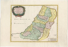
Holy Land Map, Terra Promissa or Judaea – Nicolas Sanson, c.1700
440 €Einschließlich MwSt.
Angaben zum Objekt
Holy Land Map, Terra Promissa or Judaea – Nicolas Sanson, c.1700
This antique map depicts the Holy Land, or Terra Promissa (Promised Land), as described in the Old and New Testaments, presenting Judaea divided according to biblical tradition. Titled Geographiae Sacræ ex Veteri et Novo Testamento desumptæ Tabula, in qua Terra Promissa sive Judæa, the map illustrates the land historically associated with the Twelve Tribes of Israel, with boundaries, cities, rivers, deserts, and regions carefully laid out.
The map was created by Nicolas Sanson (1600–1667), regarded as the founder of French scientific cartography. Although Sanson died in 1667, his maps continued to be published and reissued by his heirs and successors into the late 17th and early 18th centuries, making circa 1700 a plausible date for this impression. Sanson’s biblical maps were widely used for theological study, historical reference, and education, reflecting contemporary European scholarship rather than modern geographical accuracy.
The map extends from the Mediterranean coast to Arabia and Idumaea, and from Phoenicia in the north to the deserts south of Judaea. The River Jordan, the Dead Sea, Galilee, Samaria, and Judaea are prominently shown, with dense place-name detail throughout. A decorative engraved title cartouche appears in the upper left, framed by baroque foliage, reinforcing the scholarly yet ornamental character of the work. The engraving is uncoloured, emphasizing line work and textual density typical of Sanson’s cartographic style.
This map is well suited to collectors of early biblical cartography, Holy Land maps, and French 17th-century engraving. Its restrained appearance and strong historical associations also make it attractive as a decorative interior piece for libraries, studies, or gallery walls.
Condition:
Fair to good condition. Uncoloured engraved map with original old folds. Light overall toning consistent with age. Minor handling wear and light creasing visible. No major losses to the engraved surface.
Framing tips:
This map benefits from a light parchment or warm off-white mat to preserve its scholarly character. A simple dark wood or black frame works well to highlight the fine engraving and dense detail. UV-protective glazing is recommended.
Technique: Copper engraving
Maker: Nicolas Sanson, France, circa 1700
Keywords: Jerusalem, Holy Land, Holy City, Renaissance Jerusalem view, antique Jerusalem print, biblical Jerusalem, Holy Sepulchre, Temple of Solomon, Mount Zion, Gethsemane, Valley of Jehoshaphat, Jericho, biblical geography, early Holy Land map, 16th century woodcut, Renaissance woodcut, Sebastian Münster circle, antique religious print, Christian cartography, biblical city view, antique Israel print, Palestine, sacred geography, early modern cosmography
- Maße:Höhe: 43,5 cm (17,13 in)Breite: 54,2 cm (21,34 in)Tiefe: 0,2 mm (0,01 in)
- Materialien und Methoden:Papier,Graviert
- Herkunftsort:
- Zeitalter:
- Herstellungsjahr:circa 1700
- Zustand:Fair to good condition. Uncoloured engraved map with original old folds. Light overall toning consistent with age. Minor handling wear and light creasing visible. No major losses to the engraved surface.
- Anbieterstandort:Langweer, NL
- Referenznummer:Anbieter*in: BG-14153-21stDibs: LU3054348101732
Anbieterinformationen
5,0
Anerkannte Anbieter*innen
Diese renommierten Anbieter*innen sind führend in der Branche und repräsentieren die höchste Klasse in Sachen Qualität und Design.
Platin-Anbieter*in
Premium-Anbieter*innen mit einer Bewertung über 4,7 und 24 Stunden Reaktionszeit
Gründungsjahr 2009
1stDibs-Anbieter*in seit 2017
2.813 Verkäufe auf 1stDibs
Typische Antwortzeit: 1 Stunde
- VersandAngebot wird abgerufen …Versand von: Langweer, Niederlande
- Rückgabebedingungen
Einige Inhalte dieser Seite wurden automatisch übersetzt. Daher kann 1stDibs nicht die Richtigkeit der Übersetzungen garantieren. Englisch ist die Standardsprache dieser Website.
Mehr von diesem*dieser Anbieter*in
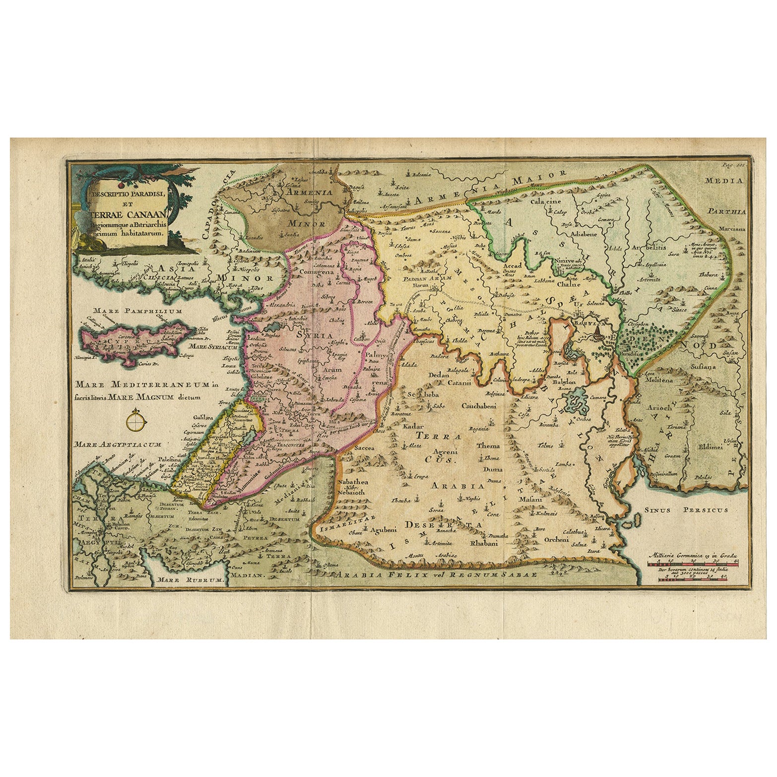
Alle anzeigenAntike Karte des Heiligen Landes und des Paradieses - Terrae Canaan Karte, ca. 1720
Antike Karte des Heiligen Landes und des Paradieses von François Halma, um 1720
Schöne handkolorierte Karte des Nahen Ostens vom Mittelmeer bis zum Persischen Golf aus dem frühen 18...
Kategorie
Antik, Frühes 18. Jahrhundert, Niederländisch, Landkarten
Materialien
Papier

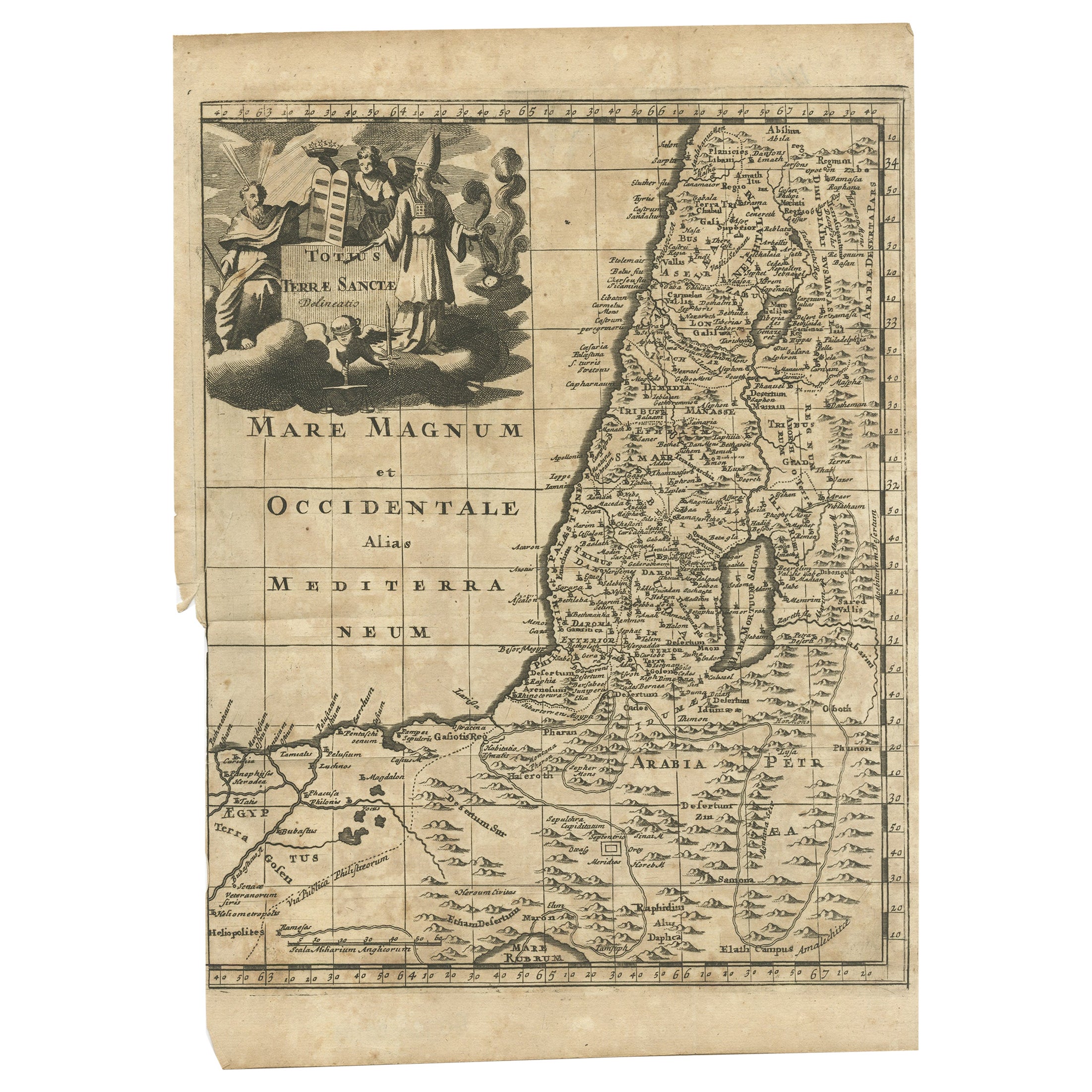
Antike Karte des Heiligen Landes, um 1710
Antike Karte mit dem Titel 'Totius Terrae Sanctae Delineatio'. Karte des Heiligen Landes, die bis nach Ägypten reicht und den Weg der Kinder Israels bei ihrem Auszug aus Ägypten in d...
Kategorie
Antik, 18. Jahrhundert, Landkarten
Materialien
Papier
Antique Holy Land Map, Twelve Tribes of Israel – Covens
Mortier, c.1700
Antique Holy Land Map, Twelve Tribes of Israel – Covens
Mortier, c.1700
Description:
This finely engraved early 18th-century map depicts the Holy Land divided according to the...
Kategorie
Antik, Frühes 18. Jahrhundert, Französisch, Landkarten
Materialien
Papier

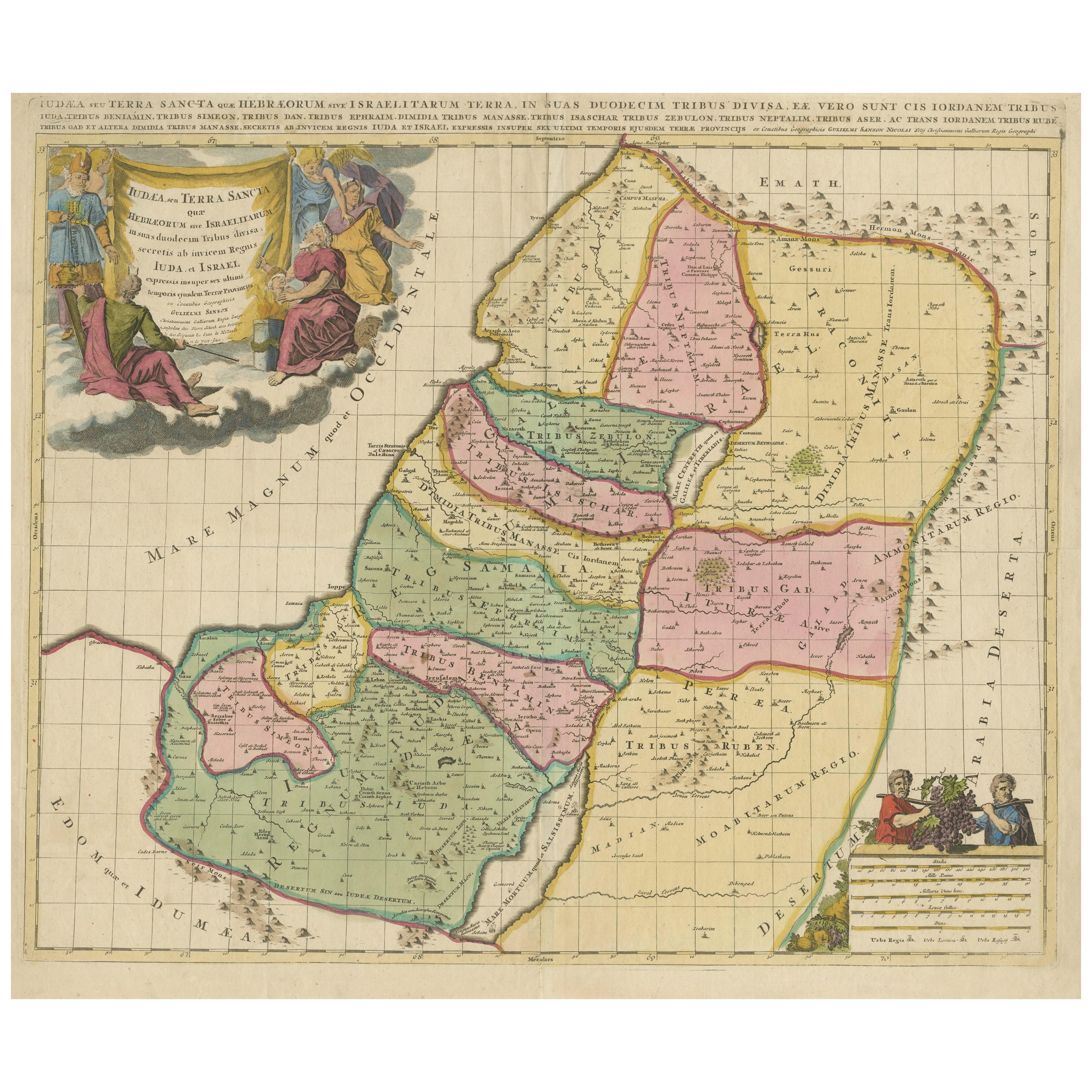
Holy Land Map of the Twelve Tribes of Israel – Sanson, Hand Colored, 1696
Holy Land Map of the Twelve Tribes of Israel – Sanson, Hand Colored, 1696
Description:
This impressive and richly hand-colored map of the Holy Land depicts the biblical territories ...
Kategorie
Antik, Spätes 17. Jahrhundert, Französisch, Landkarten
Materialien
Papier
Holy Land Map of the Twelve Tribes of Israel, After Sanson, Paris c.1798
Holy Land, Twelve Tribes of Israel – After Nicolas Sanson, De Vaugondy / Delamarche, c.1798
Description:
Holy Land. De Vaugondy (G. R.), Carte de la Terre des Hébreux ou Israélites,...
Kategorie
Antik, Spätes 18. Jahrhundert, Französisch, Landkarten
Materialien
Papier

Judaea or Terra Sancta, Twelve Tribes of Israel – Sanson Map, c.1680
Judaea or Terra Sancta, Twelve Tribes of Israel – Sanson Map, c.1680
This antique map depicts Judaea or the Holy Land divided among the Twelve Tribes of Israel, based on biblical ge...
Kategorie
Antik, Spätes 17. Jahrhundert, Niederländisch, Landkarten
Materialien
Papier
Das könnte Ihnen auch gefallen
Karte des italienischen Königreichs Sardinien und Teil des Königreichs Genua, Rom
Von Giovanni Maria Cassini
karte aus dem 18. Jahrhundert vom italienischen Kupferstecher Giovanni Maria Cassini (Italien 1745-1824). Karte eines Teils des Königreichs Sardinien und eines Teils des Königreichs ...
Kategorie
Antik, 18. Jahrhundert, Italienisch, Landkarten
Materialien
Papier

688 € Verkaufspreis
36 % Rabatt
Niederländische Karte des Heiligen Landes zu der Zeit Jesu aus dem 17. Jahrhundert von Visscher
Von Nicolaus Visscher
Diese detaillierte niederländische Karte mit dem Titel "Het Beloofe de Landt Canaan door wandelt van onsen Salichmaecker Iesu Christo, nessens syne Apostelen" von Nicolaes Visscher (...
Kategorie
1660er, Druckgrafiken und Multiples
Materialien
Gravur

883 € Verkaufspreis
20 % Rabatt
Map Holy Land La Terre Sainte gravierte van Loon veröffentlicht N de Fer 1703 Französisch, Heiliges Land
La Terre Sainte, Das Heilige Land, Tiree Des Memoires De M.De.La Rue. Par N. de Fer. Geographe de Sa Majeste Catoliq et de Monseigneur le Dauphin. Avec Privil du Roi 1703
Detailli...
Kategorie
Antik, Anfang 1700, Französisch, Louis XIV., Landkarten
Materialien
Papier

Li Governi di Borgogna – Karte aus der Antike – 1777
Li Governi di Borgogna ist eine Original-Radierung in Schwarz-Weiß auf Papier, gedruckt von Antonio Zatta in Venedig, 1777.
Originaltitel: Li Governi di Borgogna della Franca Contea...
Kategorie
1770er, Moderne, Landschaftsdrucke
Materialien
Radierung

Südgriechisches Griechenland: Eine große handkolorierte Karte des 17. Jahrhunderts von Sanson und Jaillot
Von Nicholas Sanson d
Abbeville
Diese große original handkolorierte Kupferstichkarte von Südgriechenland und der Halbinsel Peloponnes mit dem Titel "La Moree Et Les Isles De Zante, Cefalonie, Ste. Marie, Cerigo & C...
Kategorie
1690er, Landschaftsdrucke
Materialien
Gravur

Antike Karte – Gallia – Radierung von Johannes Janssonius – 1650er Jahre
Von Johannes Janssonius
Antike Landkarte - Gallia ist eine antike Landkarte aus dem Jahr 1650 von Johannes Janssonius (1588-1664).
Die Karte ist eine handkolorierte Radierung mit Coeval-Aquarellierung.
Gu...
Kategorie
1650er, Moderne, Figurative Drucke
Materialien
Radierung
