Objekte ähnlich wie Judaea or Terra Sancta, Twelve Tribes of Israel – Sanson Map, c.1680


Möchten Sie mehr Bilder oder Videos?
Zusätzliche Bilder oder Videos von dem*der Anbieter*in anfordern
1 von 9
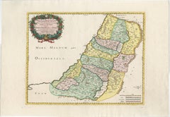
Judaea or Terra Sancta, Twelve Tribes of Israel – Sanson Map, c.1680
790 €Einschließlich MwSt.
Angaben zum Objekt
Judaea or Terra Sancta, Twelve Tribes of Israel – Sanson Map, c.1680
This antique map depicts Judaea or the Holy Land divided among the Twelve Tribes of Israel, based on biblical geography as described in the Old Testament. Titled Judæa seu Terra Sancta quæ Hebræorum sive Israelitarum Terra, in suas duodecim tribus divisa, the map presents the tribal territories both west and east of the River Jordan, including Judah, Benjamin, Simeon, Ephraim, Manasseh, Issachar, Zebulon, Asher, Naphtali, Reuben, and Gad. Major cities, deserts, mountain ranges, and waterways are carefully delineated, with the Dead Sea, River Jordan, and Mediterranean coast prominently shown.
The map was engraved after the work of Guillaume Sanson (1633–1703), son of Nicolas Sanson, the founder of French scientific cartography. This example was issued in Amsterdam around 1680, reflecting the continued popularity of Sanson’s biblical cartography in the Dutch Republic. The geography follows biblical tradition rather than modern surveying, emphasizing scriptural divisions and historical interpretation.
Decoratively, the map is distinguished by a large allegorical cartouche in the upper left, featuring classical figures presenting the title within drapery, as well as an additional decorative vignette in the lower right. The map is finely engraved on copper and finished with contemporary wash coloring to differentiate the tribal boundaries, lending both clarity and visual appeal. The combination of detailed engraving, rich iconography, and restrained coloring makes this an attractive example of late 17th-century Holy Land cartography.
This map is well suited to collectors of early biblical maps, Sanson family cartography, or 17th-century engraved maps of the Holy Land. It also works well as a decorative interior piece, particularly in a study, library, or gallery setting.
Condition:
Fair to good condition. Engraved map with original horizontal and vertical folds as issued. Occasional marginal closed tears, some light creasing, and general age-related toning. No major loss to the engraved image.
Framing tips:
This map frames well with a warm off-white or light parchment mat to complement the period paper tone. A dark wood or gilt frame enhances the allegorical cartouche and reinforces the late 17th-century character. UV-protective glazing is recommended.
Technique: Copper engraving with contemporary wash coloring
Maker: Guillaume Sanson, Amsterdam, circa 1680
- Maße:Höhe: 48,5 cm (19,1 in)Breite: 58 cm (22,84 in)Tiefe: 0,2 mm (0,01 in)
- Materialien und Methoden:Papier,Graviert
- Herkunftsort:
- Zeitalter:Spätes 17. Jahrhundert
- Herstellungsjahr:circa 1680
- Zustand:Fair to good condition. Engraved map with original horizontal and vertical folds as issued. Occasional marginal closed tears, some light creasing, and general age-related toning. No major loss to the engraved image.
- Anbieterstandort:Langweer, NL
- Referenznummer:Anbieter*in: BG-14153-11stDibs: LU3054348101662
Anbieterinformationen
5,0
Anerkannte Anbieter*innen
Diese renommierten Anbieter*innen sind führend in der Branche und repräsentieren die höchste Klasse in Sachen Qualität und Design.
Platin-Anbieter*in
Premium-Anbieter*innen mit einer Bewertung über 4,7 und 24 Stunden Reaktionszeit
Gründungsjahr 2009
1stDibs-Anbieter*in seit 2017
2.813 Verkäufe auf 1stDibs
Typische Antwortzeit: 1 Stunde
- VersandAngebot wird abgerufen …Versand von: Langweer, Niederlande
- Rückgabebedingungen
Einige Inhalte dieser Seite wurden automatisch übersetzt. Daher kann 1stDibs nicht die Richtigkeit der Übersetzungen garantieren. Englisch ist die Standardsprache dieser Website.
Mehr von diesem*dieser Anbieter*in
Alle anzeigenHoly Land Map of the Twelve Tribes of Israel, After Sanson, Paris c.1798
Holy Land, Twelve Tribes of Israel – After Nicolas Sanson, De Vaugondy / Delamarche, c.1798
Description:
Holy Land. De Vaugondy (G. R.), Carte de la Terre des Hébreux ou Israélites,...
Kategorie
Antik, Spätes 18. Jahrhundert, Französisch, Landkarten
Materialien
Papier

Antique Holy Land Map, Twelve Tribes of Israel – Covens
Mortier, c.1700
Antique Holy Land Map, Twelve Tribes of Israel – Covens
Mortier, c.1700
Description:
This finely engraved early 18th-century map depicts the Holy Land divided according to the...
Kategorie
Antik, Frühes 18. Jahrhundert, Französisch, Landkarten
Materialien
Papier

Handkolorierte Karte des Heiligen Landes, aufgeteilt unter den zwölf Stämmen, ca. 1720
Handkolorierte Karte des Heiligen Landes, aufgeteilt unter den zwölf Stämmen, ca. 1720
Diese eindrucksvolle antike Karte mit dem Titel "Iudaea seu Palaestina ob Sacratissima Redemto...
Kategorie
Antik, Frühes 18. Jahrhundert, Deutsch, Landkarten
Materialien
Papier

Antike Karte des Heiligen Landes und des Paradieses - Terrae Canaan Karte, ca. 1720
Antike Karte des Heiligen Landes und des Paradieses von François Halma, um 1720
Schöne handkolorierte Karte des Nahen Ostens vom Mittelmeer bis zum Persischen Golf aus dem frühen 18...
Kategorie
Antik, Frühes 18. Jahrhundert, Niederländisch, Landkarten
Materialien
Papier

Antique French Map of the Holy Land, Twelve Tribes of Israel, c.1750
Antique Holy Land Map, Twelve Tribes of Israel – Robert de Vaugondy, c.1750
Description
This finely engraved and hand-colored map depicts Judea, or the Holy Land, divided according ...
Kategorie
Antik, Mitte des 18. Jahrhunderts, Französisch, Landkarten
Materialien
Papier
Holy Land Map of the Twelve Tribes of Israel – Sanson, Hand Colored, 1696
Holy Land Map of the Twelve Tribes of Israel – Sanson, Hand Colored, 1696
Description:
This impressive and richly hand-colored map of the Holy Land depicts the biblical territories ...
Kategorie
Antik, Spätes 17. Jahrhundert, Französisch, Landkarten
Materialien
Papier
Das könnte Ihnen auch gefallen
Südgriechisches Griechenland: Eine große handkolorierte Karte des 17. Jahrhunderts von Sanson und Jaillot
Von Nicholas Sanson d
Abbeville
Diese große original handkolorierte Kupferstichkarte von Südgriechenland und der Halbinsel Peloponnes mit dem Titel "La Moree Et Les Isles De Zante, Cefalonie, Ste. Marie, Cerigo & C...
Kategorie
1690er, Landschaftsdrucke
Materialien
Gravur

Southern Greece: Eine große handkolorierte Karte aus dem 17. Jahrhundert von Sanson und Jaillot
Von Nicolas Sanson
Diese große original handkolorierte Kupferstichkarte von Südgriechenland und der Halbinsel Peloponnes mit dem Titel "La Moree Et Les Isles De Zante, Cefalonie, Ste. Marie, Cerigo & C...
Kategorie
Antik, 1690er, Französisch, Landkarten
Materialien
Papier

1.368 € Verkaufspreis
20 % Rabatt
„Nova Barbariae Descriptio“, eine handkolorierte nordafrikanische Karte aus dem 17. Jahrhundert
Von Johannes Janssonius
Diese attraktive handkolorierte Original-Karte von Nordafrika aus dem 17. Jahrhundert mit dem Titel "Nova Barbariae Descriptio" von Johannes Janssonius wurde 1635 in Paris veröffentl...
Kategorie
Antik, Mitte 17. Jahrhundert, Niederländisch, Landkarten
Materialien
Papier

883 € Verkaufspreis
20 % Rabatt
Map Holy Land La Terre Sainte gravierte van Loon veröffentlicht N de Fer 1703 Französisch, Heiliges Land
La Terre Sainte, Das Heilige Land, Tiree Des Memoires De M.De.La Rue. Par N. de Fer. Geographe de Sa Majeste Catoliq et de Monseigneur le Dauphin. Avec Privil du Roi 1703
Detailli...
Kategorie
Antik, Anfang 1700, Französisch, Louis XIV., Landkarten
Materialien
Papier

Antike Karte – Mar Di Athiopia – Radierung von Johannes Janssonius – 1650er Jahre
Von Johannes Janssonius
Antike Landkarte - Mar Di Athiopia ist eine antike Landkarte aus dem Jahre 1650 von Johannes Janssonius (1588-1664).
Die Karte ist handkolorierte Radierung, mit Coeval Aquarellang.
...
Kategorie
1650er, Moderne, Figurative Drucke
Materialien
Radierung

Karte des italienischen Königreichs Sardinien und Teil des Königreichs Genua, Rom
Von Giovanni Maria Cassini
karte aus dem 18. Jahrhundert vom italienischen Kupferstecher Giovanni Maria Cassini (Italien 1745-1824). Karte eines Teils des Königreichs Sardinien und eines Teils des Königreichs ...
Kategorie
Antik, 18. Jahrhundert, Italienisch, Landkarten
Materialien
Papier

688 € Verkaufspreis
36 % Rabatt