Objekte ähnlich wie Mozambique Bay – French Naval Sea Chart by Bellin, c.1765

Möchten Sie mehr Bilder oder Videos?
Zusätzliche Bilder oder Videos von dem*der Anbieter*in anfordern
1 von 9
Mozambique Bay – French Naval Sea Chart by Bellin, c.1765
385 €Einschließlich MwSt.
Angaben zum Objekt
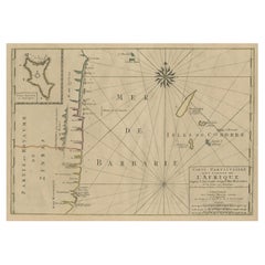
Mozambique Bay – French Naval Sea Chart by Bellin, c.1765
This detailed French sea chart depicts the Bay of Mozambique and the strategically vital island settlement of Mozambique, shown with its fortifications, anchorages, and surrounding islands. The map is titled “Carte de la Baye de Mosambique” and was engraved under the direction of Jacques-Nicolas Bellin, Hydrographer to the French King. It was published in Paris as part of Bellin’s hydrographic work for the Dépôt des cartes et plans de la Marine, circa 1760–1770.
Compiled from multiple manuscript sources, as stated directly in the cartouche (“Dressée sur divers Manuscrits”), the chart reflects the French navy’s effort to refine and correct earlier English and Portuguese mapping of the East African coast. Bellin explicitly notes that this chart differs significantly from English versions previously published, underscoring its role as an authoritative French alternative.
The map focuses on navigational precision. Soundings are carefully plotted throughout the bay, with shoals, reefs, and sandbanks clearly indicated. The fortified island of Mozambique is shown in detail, including the fort, town layout, batteries, and older fortifications. Surrounding islands such as St. George, St. Jacques, and Isle de Luchaque are identified, along with named channels and passes suitable for navigation.
A large compass rose dominates the lower right quadrant, reinforcing the chart’s maritime purpose. Coastal profiles, river mouths, and interior relief are rendered with clarity and restraint, typical of Bellin’s clean and highly legible engraving style. The overall composition balances technical accuracy with visual elegance.
This chart is an important document of 18th-century Indian Ocean navigation and colonial competition. Mozambique was a key hub linking East Africa with Arabia, India, and European trade networks, and Bellin’s charts of the region are increasingly sought after for both their historical relevance and decorative appeal.
Condition report
Good condition overall. Light, even age toning. Minor scattered spots and faint handling marks consistent with period. Plate mark visible. Full margins.
Framing tips
A light warm mat (ivory or pale sand) works well with the soft paper tone and monochrome engraving. A dark wood or black-stained frame enhances the strong graphic contrast of the coastline and compass rose, giving the map a refined, museum-style presentation. Ideal as a stand-alone piece or paired with Indian Ocean island charts.
Technique: Copper engraving
Maker: Jacques-Nicolas Bellin, France, c.1765
- Maße:Höhe: 25,5 cm (10,04 in)Breite: 18,9 cm (7,45 in)Tiefe: 0,2 mm (0,01 in)
- Materialien und Methoden:Papier,Graviert
- Herkunftsort:
- Zeitalter:1760–1769
- Herstellungsjahr:circa 1765
- Zustand:Good condition overall. Light, even age toning. Minor scattered spots and faint handling marks consistent with period. Plate mark visible. Full margins.
- Anbieterstandort:Langweer, NL
- Referenznummer:Anbieter*in: BG-14128-21stDibs: LU3054348016572
Anbieterinformationen
5,0
Anerkannte Anbieter*innen
Diese renommierten Anbieter*innen sind führend in der Branche und repräsentieren die höchste Klasse in Sachen Qualität und Design.
Platin-Anbieter*in
Premium-Anbieter*innen mit einer Bewertung über 4,7 und 24 Stunden Reaktionszeit
Gründungsjahr 2009
1stDibs-Anbieter*in seit 2017
2.813 Verkäufe auf 1stDibs
Typische Antwortzeit: 1 Stunde
- VersandAngebot wird abgerufen …Versand von: Langweer, Niederlande
- Rückgabebedingungen
Einige Inhalte dieser Seite wurden automatisch übersetzt. Daher kann 1stDibs nicht die Richtigkeit der Übersetzungen garantieren. Englisch ist die Standardsprache dieser Website.
Mehr von diesem*dieser Anbieter*in
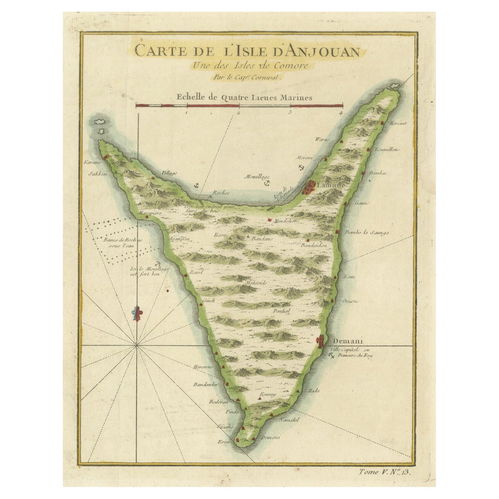
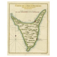
Alle anzeigenAnjouan Island, Comoros – French Naval Sea Chart by Bellin, c.1765
Anjouan Island, Comoros – French Naval Sea Chart by Bellin, c.1765
This finely engraved French sea chart depicts the island of Anjouan (Ndzuwani), one of the Comoros Islands in the ...
Kategorie
Antik, 1760er, Französisch, Landkarten
Materialien
Papier
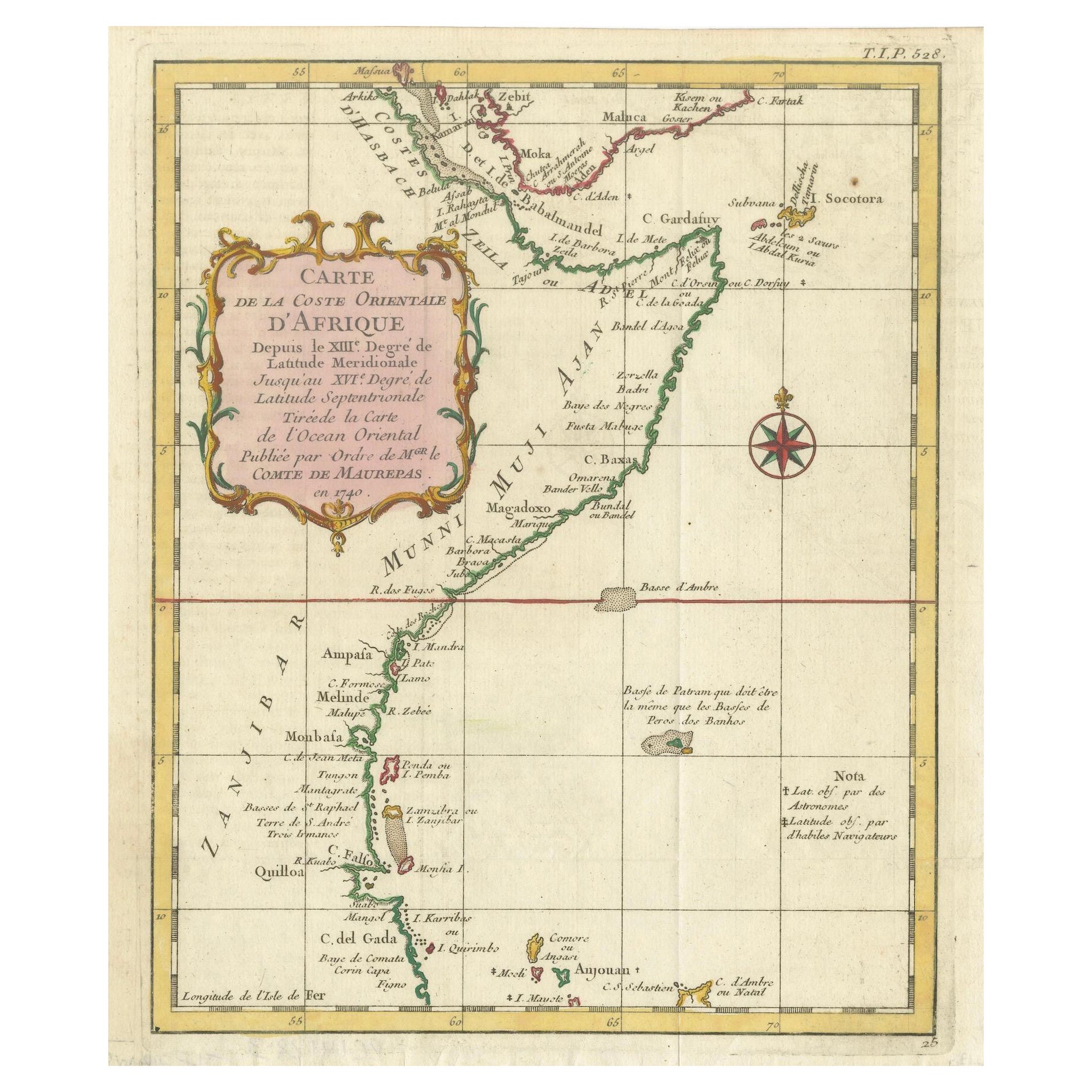
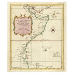
East African Coast – French Map by Bellin, Zanzibar to Arabia, 1740
East African Coast – French Map by Bellin, Zanzibar to Arabia, 1740
This important French map depicts the eastern coast of Africa from Mozambique and Zanzibar northward to the Horn ...
Kategorie
Antik, 1740er, Französisch, Landkarten
Materialien
Papier
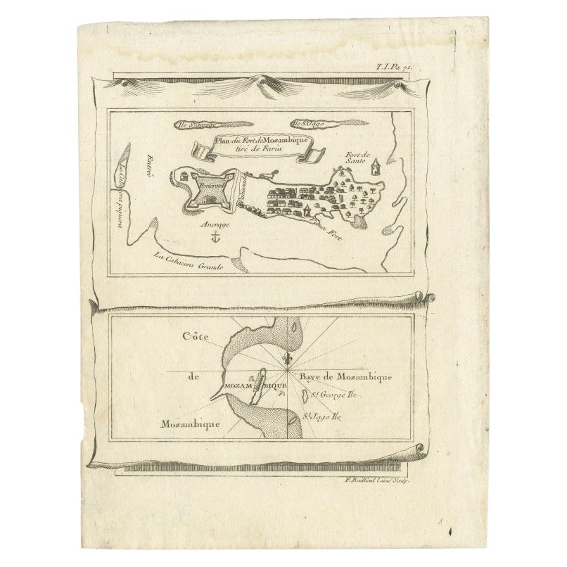
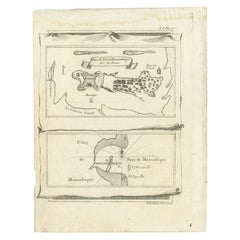
Antike Karte der Bucht von Mosambik und eine Karte von Fort de Mozambik, um 1759
Zwei antike Karten auf einem Blatt. Die obere antike Karte trägt den Titel "Plan du Fort de Mozambique tiré de Faria" und zeigt die Insel Mosambik mit ihrem Fort, der Siedlung, dem H...
Kategorie
Antik, 18. Jahrhundert, Landkarten
Materialien
Papier
Martinique Karte von Rigobert Bonne - Antike französische Karte, um 1768
Karte von Martinique von Rigobert Bonne, um 1768
Dies ist eine detaillierte antike Karte von Martinique mit dem Titel "Isle de la Martinique", gestochen von Rigobert Bonne um 1768 f...
Kategorie
Antik, 1760er, Französisch, Landkarten
Materialien
Papier

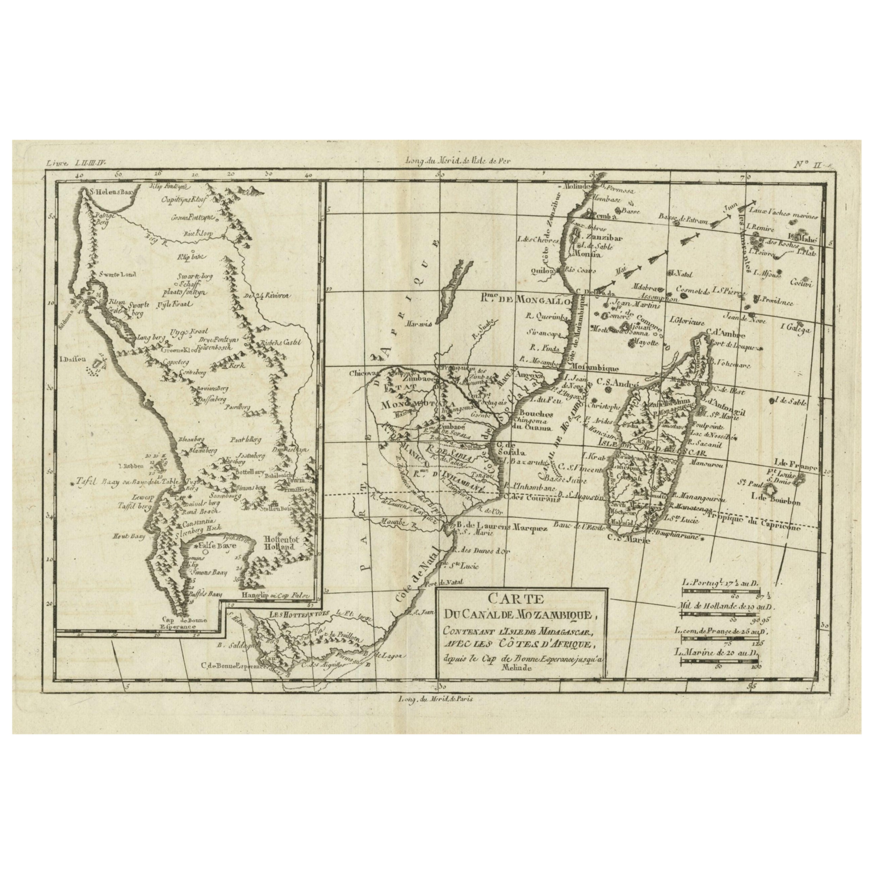
Antike Karte des Mosambik-Kanals mit Madagaskar und Einfassung der Kapregion, 1780
Antike Karte mit dem Titel 'Carte du canal de Mosambique, contenant l'Isle de Madagascar avec les Cotes d'Afrique.' Karte des Mosambik-Kanals, der die Insel Madagaskar mit den Küsten...
Kategorie
Antik, 18. Jahrhundert, Landkarten
Materialien
Papier
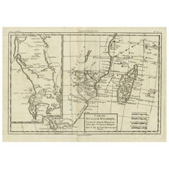
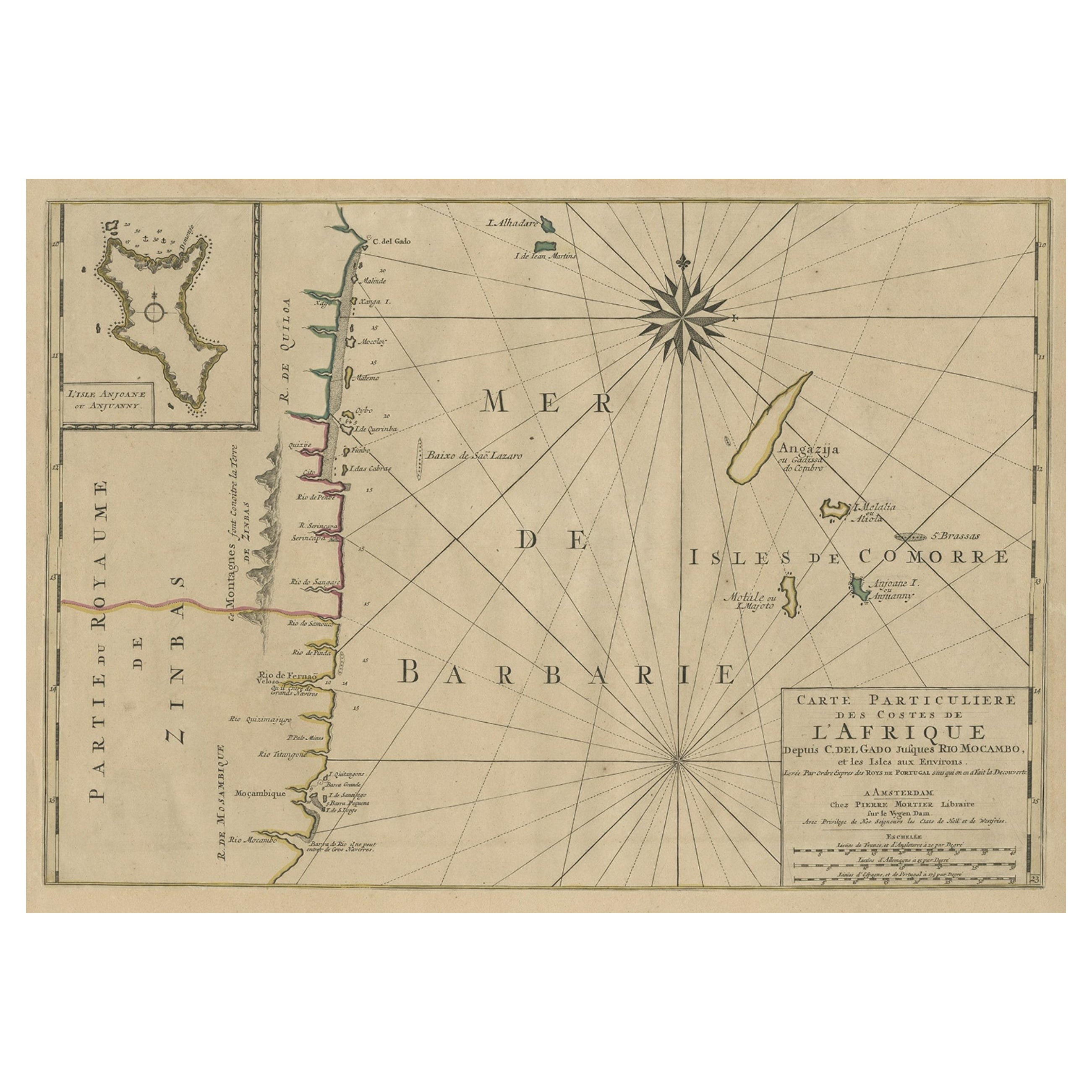
Karte der Küste von Mosambik und Tansanien mit eingelegter Karte der Insel Anjouan, ca. 1700
Antike Karte mit dem Titel 'Carte particuliere des Costes de l'Afrique'.
Zeigt die Küsten von Mosambik und Tansania. Mit einer beigefügten Karte der Insel Anjouan.
Künstler un...
Kategorie
Antik, Anfang 1700, Landkarten
Materialien
Papier
512 € Verkaufspreis
20 % Rabatt
Das könnte Ihnen auch gefallen
Bellin Karte der Westküste Afrikas, 18. Jahrhundert; Guinea und Sierra Leone
Jacques Bellins Kupferstichkarte mit dem Titel "Partie de la Coste de Guinee Dupuis la Riviere de Sierra Leona Jusquau Cap das Palmas", die die Küste von Guinea und Sierra Leone in W...
Kategorie
1740er, Alte Meister, Landschaftsdrucke
Materialien
Gravur

398 € Verkaufspreis
20 % Rabatt
Westafrikanische Westküste, Guinea und Sierra Leone: Eine Karte aus dem 18. Jahrhundert von Bellin
Von Jacques-Nicolas Bellin
Die Kupferstichkarte von Jacques Bellin mit dem Titel "Partie de la Coste de Guinee Dupuis la Riviere de Sierra Leona Jusquau Cap das Palmas", die die Küste von Guinea und Sierra Leo...
Kategorie
Antik, Mitte des 18. Jahrhunderts, Französisch, Landkarten
Materialien
Papier

398 € Verkaufspreis
20 % Rabatt
Karte der Insel Kuba - Guillaume Thomas Raynal (1711-1796)
Diese historische Karte der Insel Kuba wurde im späten 18. Jahrhundert erstellt und stammt aus einer Ausgabe des "Atlas de toutes les parties connues du globe terrestre" des französi...
Kategorie
Antik, 18. Jahrhundert, Drucke
Materialien
Glas, Papier

129 € Verkaufspreis
50 % Rabatt
Kostenloser Versand
Antike antike 1765 klappbare Landkarte von Frankreich, Bordeau usw.
Route du Carosse de Bordeaux, part de Paris tous les Mardis a 11 matin. a et pafse 1765 ist eine umfassende Karte mit zwei Routen durch das Weinland Frankreichs, die in Paris begin...
Kategorie
1760er, Sonstige Kunststile, Landschaftsdrucke
Materialien
Radierung

Cadiz-Insel: Eine gerahmte, handkolorierte Karte aus Blaeu
s Atlas Major aus dem 17. Jahrhundert
Von Joan (Johannes) Blaeu
Dies ist eine handkolorierte Karte aus dem 17. Jahrhundert mit dem Titel "Insula Gaditana Isla de Cadiz" aus dem Atlas Maior von Johannes (Joan) Blaeu, der 1662 in Amsterdam veröffen...
Kategorie
Mitte 17. Jahrhundert, Alte Meister, Landschaftsdrucke
Materialien
Gravur

Antike Karte – Mare Pacificum – Radierung von Johannes Janssonius – 1650er Jahre
Von Johannes Janssonius
Mare Pacificum ist eine antike Karte aus dem Jahr 1650 von Johannes Janssonius (1588-1664).
Die Karte ist handkolorierte Radierung, mit Coeval Aquarellang.
Guter Zustand mit leicht...
Kategorie
1650er, Moderne, Figurative Drucke
Materialien
Radierung
