Objekte ähnlich wie Ottoman Empire Map 1719 – Europe Asia Africa, Jean Chiquet, Paris

Möchten Sie mehr Bilder oder Videos?
Zusätzliche Bilder oder Videos von dem*der Anbieter*in anfordern
1 von 9
Ottoman Empire Map 1719 – Europe Asia Africa, Jean Chiquet, Paris
470 €Einschließlich MwSt.
Angaben zum Objekt
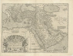
Title: Ottoman Empire Map 1719 – Europe Asia Africa, Jean Chiquet, Paris
Description:
Original early-18th-century engraved map titled Estats de l’Empire du Grand Seigneur, depicting the Ottoman Empire across three continents: Europe, Asia, and Africa. This example is clearly dated 1719 in the engraved cartouche and bears the publisher’s imprint Chez Jacq. Chiquet à Paris 1719.
The map presents the Ottoman Empire at an early Enlightenment moment, extending from Central and Southeastern Europe through Anatolia and the Levant, across Mesopotamia and Arabia, and into Egypt and the North African Barbary Coast. Political regions are defined by engraved boundaries and differentiated with original hand coloring, while coastlines, rivers, and seas are rendered with strong copper engraving typical of early 18th-century French map production.
French toponymy is dense and legible, with major cities and regions clearly identified, including Constantinople, Aleppo, Damascus, Baghdad, Cairo, Mecca, and Jerusalem. The Mediterranean, Black Sea, Red Sea, and Caspian Sea anchor the composition and emphasize the empire’s strategic maritime reach.
The decorative cartouche at upper right contains the full title and date, identifying the Ottoman ruler as “Grand Seigneur,” Sultan and Emperor of the Turks, ruling territories in Europe, Asia, and Africa. A lower table listing Ottoman rulers reinforces the political and didactic purpose of the map, which was intended both for geographic reference and informed private collecting.
Issued by Jean Chiquet, a Parisian map seller active in the early 18th century, this map reflects the commercial dissemination of authoritative geographic models during the reign of Louis XV. It combines political clarity with restrained decorative appeal, making it equally suitable for scholarly collections and interior display.
Condition report:
Copper engraving with original hand coloring. Age-related toning and light spotting consistent with an early 18th-century print. Minor edge wear and small handling marks, mainly in the margins. Plate mark visible. No major losses or repairs. Overall very good condition for a map dated 1719.
Framing tips:
Preserve the full margins and visible plate mark with a wide ivory or parchment-toned mat. A walnut, ebonized wood, or muted antique gold frame complements the period character. For a cleaner contemporary look, use a slim black frame with generous off-white matting.
SEO keyword block:
Ottoman Empire map 1719, antique Ottoman map, Jean Chiquet map, Middle East map 18th century, Holy Land map antique, Arabia map 1719, Turkey map antique, Islamic world map, French engraved map, hand colored antique map, Europe Asia Africa map
Technique: Copper engraving with original hand coloring
Maker: Jean Chiquet, Paris, 1719
- Maße:Höhe: 20,6 cm (8,12 in)Breite: 27,8 cm (10,95 in)Tiefe: 0,2 mm (0,01 in)
- Materialien und Methoden:Papier,Graviert
- Herkunftsort:
- Zeitalter:
- Herstellungsjahr:1719
- Zustand:Copper engraving with original hand coloring. Age-related toning and light spotting consistent with an early 18th-century print. Minor edge wear and small handling marks, mainly in the margins. Plate mark visible. No major losses or repairs.
- Anbieterstandort:Langweer, NL
- Referenznummer:Anbieter*in: BG-141971stDibs: LU3054348065702
Anbieterinformationen
5,0
Anerkannte Anbieter*innen
Diese renommierten Anbieter*innen sind führend in der Branche und repräsentieren die höchste Klasse in Sachen Qualität und Design.
Platin-Anbieter*in
Premium-Anbieter*innen mit einer Bewertung über 4,7 und 24 Stunden Reaktionszeit
Gründungsjahr 2009
1stDibs-Anbieter*in seit 2017
2.811 Verkäufe auf 1stDibs
Typische Antwortzeit: 1 Stunde
- VersandAngebot wird abgerufen …Versand von: Langweer, Niederlande
- Rückgabebedingungen
Einige Inhalte dieser Seite wurden automatisch übersetzt. Daher kann 1stDibs nicht die Richtigkeit der Übersetzungen garantieren. Englisch ist die Standardsprache dieser Website.
Mehr von diesem*dieser Anbieter*in
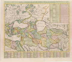
Alle anzeigenMap des östlichen Römischen Kaiserreichs aus dem 18. Jahrhundert von Henri Chatelain, um 1719
Titel: Karte des Oströmischen Reiches aus dem 18. Jahrhundert von Henri Chatelain, um 1719
Beschreibung: Diese detailreiche Karte mit dem Titel *Nouvelle Carte pour Servir à l'Histo...
Kategorie
Antik, 1710er, Landkarten
Materialien
Papier
Fein gravierte historische Karte des Nahen Osten und Asien, um 1745
Beschreibung: Antike Karte mit dem Titel "Theatrum Historicum pars Orientalis"
Fein gestochene historische Karte mit einer Fülle von Details. Sie zeigt den Nahen Osten und Asien....
Kategorie
Antik, 1740er, Landkarten
Materialien
Papier

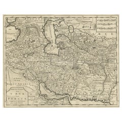
Karte von Persien, dem Kaspischen Meer und Indien - Isaak Tirion, ca. 1730
Karte von Persien und den umliegenden Regionen - "Nieuwe Kaart van 't Ryck van Persie" von Isaak Tirion, Amsterdam, ca. 1730
Diese fein detaillierte Kupferstichkarte mit dem Titel "...
Kategorie
Antik, Mitte des 18. Jahrhunderts, Niederländisch, Landkarten
Materialien
Papier
Originale antike Originalkarte des türkischen Reiches mit Ägypten, 1778
Titel: Etats Due Grand-Seigneur En Asie, Empire De Perse, Pays Des Usbecs, Arabie et Egypte . . . 1753
Detaillierte Karte des türkischen Reiches, das sich bis zum Schwarzen Meer, ...
Kategorie
Antik, 1770er, Französisch, Landkarten
Materialien
Papier

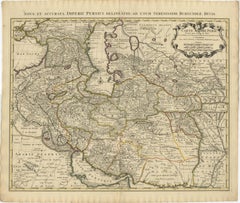
Antike Karte des persischen Empires aus dem Jahr 1742 mit detaillierten Rändern und Kartusche
Titel: 1742 Covens & Mortier Karte des persischen Reiches von Guillaume De L'Isle
Diese bemerkenswerte Karte von 1742, "Carte de Perse", wurde ursprünglich von Guillaume De L'Isle...
Kategorie
Antik, 1740er, Niederländisch, Landkarten
Materialien
Papier
1.296 € Verkaufspreis
20 % Rabatt
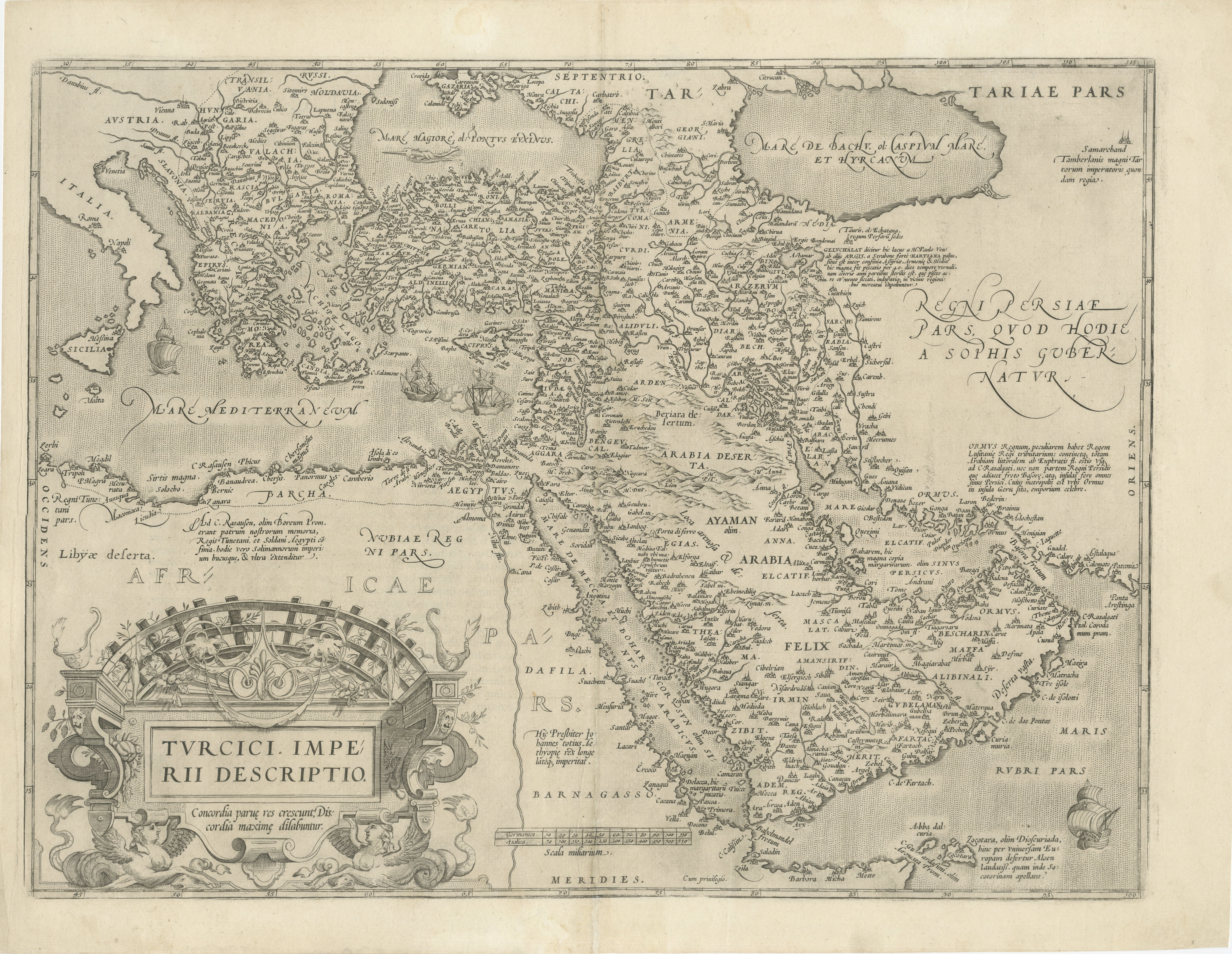
Map of the Ottoman Empire and Near East aus dem 16. Jahrhundert: Turcicici Imperii Descriptio
Titel: Original-Karte des Osmanischen Reiches und des Nahen Ostens aus dem 16. Jahrhundert: *Turcici Imperii Descriptio* von Ortelius, 1571
Dieser seltene Kupferstich, Turcici Imp...
Kategorie
Antik, 16. Jahrhundert, Europäisch, Landkarten
Materialien
Papier
1.280 € Verkaufspreis
20 % Rabatt
Das könnte Ihnen auch gefallen
Antike französische Karte von Asien, einschließlich China, Indonesien und Indien, 1783
Sehr schöne Karte von Asien. 1783 Dedie au Roy.
Zusätzliche Informationen:
Land der Herstellung: Europa
Zeitraum: 18. Jahrhundert Qing (1661 - 1912)
Zustand: Gesamtzustand B (Good U...
Kategorie
Antik, 18. Jahrhundert, Europäisch, Landkarten
Materialien
Papier

421 € Verkaufspreis
40 % Rabatt
1718 Ides
Witsen Karte „Route D
amsterdam a Moscow Et De La Ispahan Et Gamron
1718 Ides & Witsen Karte, betitelt
"Route D'Amsterdam A Moscow Et De La Ispahan Et Gamron,"
Ric.b005
Thema: Osteuropa und Zentralasien
Zeitraum: 1718 (veröffentlicht)
Veröffe...
Kategorie
Antik, Frühes 18. Jahrhundert, Niederländisch, Landkarten
Materialien
Papier

Süd- und Osteuropa: Eine große handkolorierte Karte aus dem 17. Jahrhundert von Sanson
Jaillot
Von Nicolas Sanson
Diese große handkolorierte Karte mit dem Titel "Estats de L'Empire des Turqs en Europe, ou sont les Beglerbeglicz our Gouvernements" wurde ursprünglich von Nicholas Sanson d'Abbevill...
Kategorie
Antik, 1690er, Französisch, Landkarten
Materialien
Papier

1.507 € Verkaufspreis
20 % Rabatt
Persische, armenische und adjektive Regionen: Eine handkolorierte Karte aus dem 17. Jahrhundert von De Wit
Von Frederick de Wit
Eine große handkolorierte Kupferstichkarte aus dem 17. Jahrhundert mit dem Titel "Novissima nec non Perfectissima Scandinaviae Tabula comprehendens Regnorum Sueciae, Daniae et Norveg...
Kategorie
Antik, Spätes 17. Jahrhundert, Niederländisch, Landkarten
Materialien
Papier

1.299 € Verkaufspreis
20 % Rabatt
Persien, Armenien, Natoliae et Arabiae Descriptio per Frederick deWit 1666 Karte
Karte von Persiae, Armeniae, Natoliae et Arabiae Descriptio per F de Wit 1688 Kupferstich aus: Atlas Contractus Orbis Terrarum Praecipuas ac Novissimas Complectens Tabulas. Amst...
Kategorie
1660er, Realismus, Landschaftsdrucke
Materialien
Gravur

Map of the East Indies: Eine handkolorierte Karte aus dem 18. Jahrhundert von E. Bowen
Dies ist ein Original 18. Jahrhundert handkolorierte Karte mit dem Titel "An Accurate Map of the East Indies Exhibiting the Course of the European Trade...
Kategorie
Mitte des 18. Jahrhunderts, Alte Meister, Landschaftsdrucke
Materialien
Gravur

883 € Verkaufspreis
20 % Rabatt