Objekte ähnlich wie River Sanaga, West Africa – Elegant French Exploration Map, c.1750


Möchten Sie mehr Bilder oder Videos?
Zusätzliche Bilder oder Videos von dem*der Anbieter*in anfordern
1 von 9
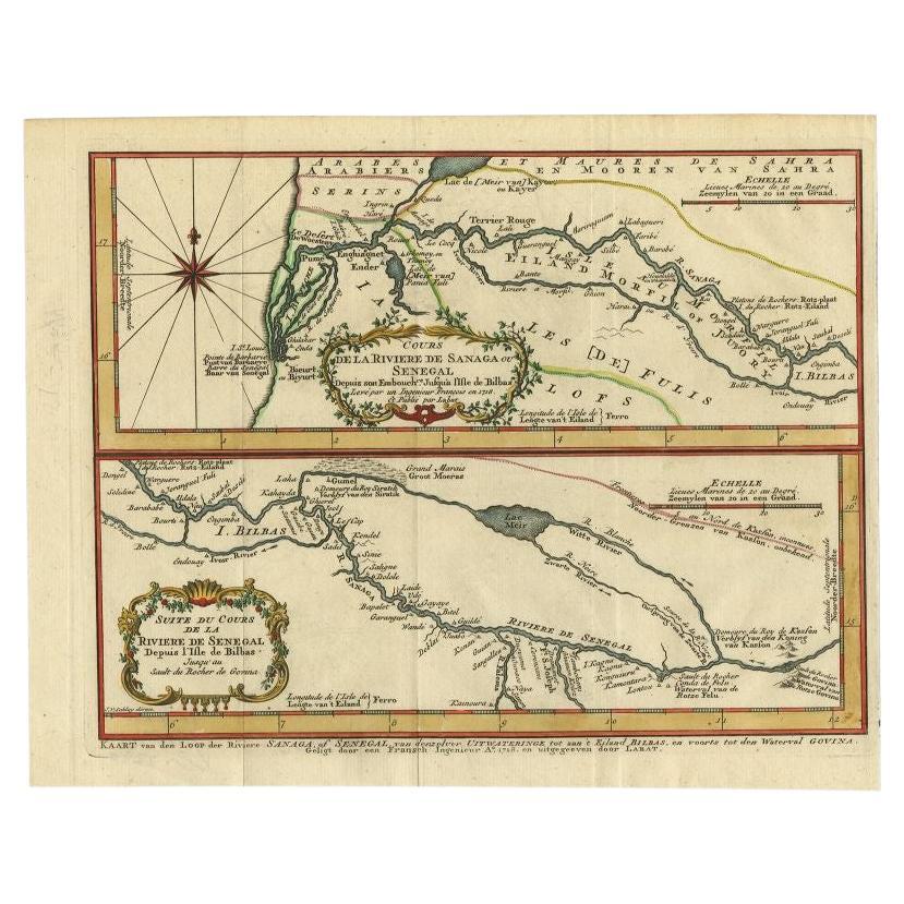
River Sanaga, West Africa – Elegant French Exploration Map, c.1750
630 €Einschließlich MwSt.
Angaben zum Objekt
Nubia and Abyssinia – Venetian Map of Northeast Africa, Zatta, 1784
This detailed late-18th-century map depicts Nubia and Abyssinia, covering large parts of present-day Sudan, Ethiopia, Eritrea, and the Horn of Africa. The map is titled “La Nubia ed Abissinia” and was published in Venice in 1784 by Antonio Zatta, one of the most important Italian map publishers of the period. It forms part of Zatta’s monumental Atlante Novissimo, produced with the privilege of the Venetian Senate.
The map presents the Nile basin in exceptional detail, tracing the river from its upper reaches through Nubia toward Egypt, while also mapping the Red Sea coast, inland mountain ranges, deserts, and regional kingdoms. Political and regional boundaries are outlined in contemporary hand color, distinguishing Nubia, Abyssinia, and neighboring territories. Numerous towns, tribal regions, rivers, and topographical features are carefully named, reflecting the synthesis of classical sources, Jesuit reports, and more recent travel accounts available to European geographers in the late Enlightenment period.
Zatta’s cartography represents the Italian continuation of the scientific mapping tradition pioneered by Delisle and d’Anville, emphasizing clarity, proportional accuracy, and critical compilation of sources. While interior Africa remained imperfectly known, this map shows a marked departure from earlier speculative geography, replacing legend with measured structure and comparative reasoning.
The decorative title cartouche, engraved in a restrained architectural style, anchors the upper right and reflects the sober elegance characteristic of Venetian Enlightenment cartography. Latitude and longitude lines, clean engraving, and balanced composition give the map strong visual presence without excess ornamentation.
This map is particularly appealing to collectors of African cartography, Nile exploration history, Ethiopian history, and Enlightenment-era geography. It also serves as an excellent intellectual counterpart to earlier French coastal and regional charts of Africa, illustrating the progression of European geographic knowledge during the 18th century.
Condition report
Good condition overall. Central vertical fold as issued. Light age toning and some mild discoloration, more noticeable along the fold. Minor scattered spots and faint handling marks. Original outline hand color. Plate mark visible. Margins intact.
Framing tips
A wide off-white or light sand-colored mat is recommended to balance the dense interior detail and preserve visual calm. A medium to dark wood frame enhances the engraved line work and complements the restrained hand coloring. Particularly effective as a scholarly centerpiece or paired with Indian Ocean or Nile-related maps.
Technique: Copper engraving with contemporary outline hand color
Maker: Antonio Zatta, Venice, 1784
Keywords: Nubia map, Abyssinia map, Ethiopia antique map, Northeast Africa cartography, Nile map, Blue Nile, White Nile, Red Sea map, Horn of Africa, Ethiopian Highlands, Kingdom of Nubia, Kingdom of Abyssinia, Gondar, Axum, Aksum, Sennar, Dongola, Suakin, Massawa, Zeila, Bab el Mandeb, Red Sea trade routes, Mecca, Mekka, Meca, Arabian Peninsula, African exploration map, 18th century map Africa, Venetian map, Antonio Zatta, Atlante Novissimo, Enlightenment cartography, antique engraved map
- Maße:Höhe: 34,7 cm (13,67 in)Breite: 43,7 cm (17,21 in)Tiefe: 0,2 mm (0,01 in)
- Materialien und Methoden:Papier,Graviert
- Herkunftsort:
- Zeitalter:1750–1759
- Herstellungsjahr:circa 1750
- Zustand:Good condition overall. Central vertical fold as issued. Light age toning and some mild discoloration, more noticeable along the fold. Minor scattered spots and faint handling marks. Original outline hand color. Plate mark visible. Margins intact.
- Anbieterstandort:Langweer, NL
- Referenznummer:Anbieter*in: BG-14128-61stDibs: LU3054348017042
Anbieterinformationen
5,0
Anerkannte Anbieter*innen
Diese renommierten Anbieter*innen sind führend in der Branche und repräsentieren die höchste Klasse in Sachen Qualität und Design.
Platin-Anbieter*in
Premium-Anbieter*innen mit einer Bewertung über 4,7 und 24 Stunden Reaktionszeit
Gründungsjahr 2009
1stDibs-Anbieter*in seit 2017
2.816 Verkäufe auf 1stDibs
Typische Antwortzeit: 1 Stunde
- VersandAngebot wird abgerufen …Versand von: Langweer, Niederlande
- Rückgabebedingungen
Einige Inhalte dieser Seite wurden automatisch übersetzt. Daher kann 1stDibs nicht die Richtigkeit der Übersetzungen garantieren. Englisch ist die Standardsprache dieser Website.
Mehr von diesem*dieser Anbieter*in
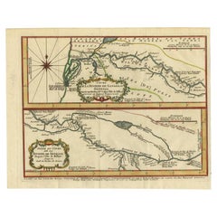
Alle anzeigenAntike Karte des Sanaga- Flusses, Senegal, 1747
Antike Karte mit dem Titel 'Cours De La Riviere De Sanaga Ou Senegal (..) - Kaart van den Loop der Riviere Sanaga (..)'. Attraktive Doppelkarte des Sanaga-Flusses, Senegal, Afrika. D...
Kategorie
Antik, 18. Jahrhundert, Landkarten
Materialien
Papier
Antike Karte des Gambia-Flusses von J. Van Schley, um 1750
"Carte de la Riviere de Gambra ou Gambie. Depuis son Embouchure Jusqu a Eropina". Orig. Kupferstich nach Capt. J. Leach's Karte der Region von 1732. Mit ornamentaler Titelkartusche u...
Kategorie
Antik, Mitte des 18. Jahrhunderts, Landkarten
Materialien
Papier

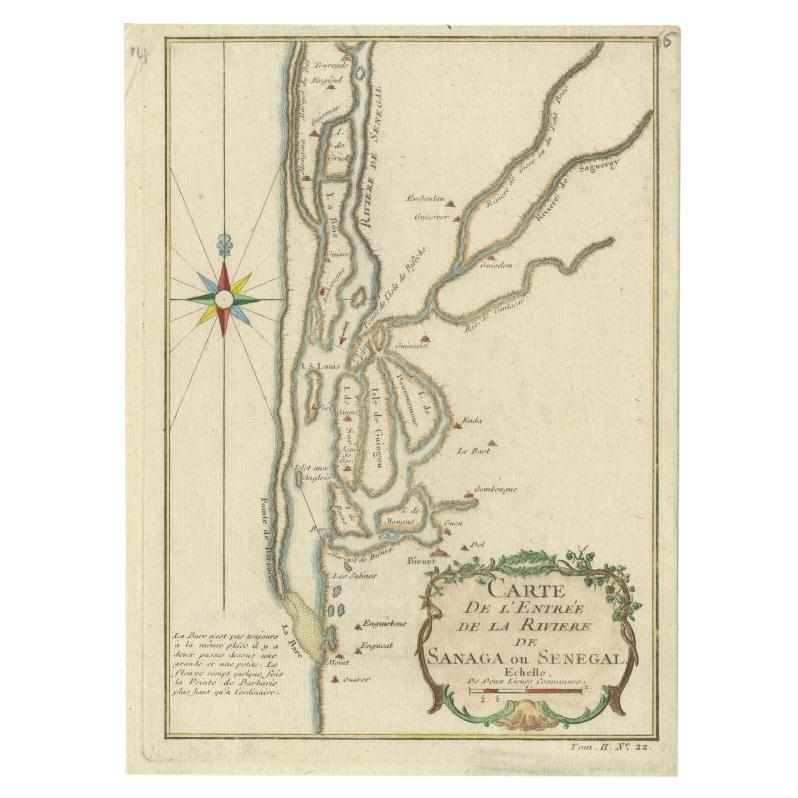
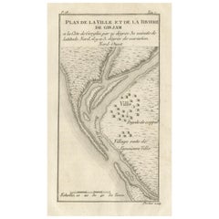
Antike Karte des Senegal-Flusses von Bellin, 1746
Antike Karte mit dem Titel "Carte de l'Entrée de la Rivière de Sanaga ou Senegal". Karte der Mündung des Senegal-Flusses. Diese Karte stammt aus Prevosts "Histoire Generale des Voyag...
Kategorie
Antik, 18. Jahrhundert, Landkarten
Materialien
Papier
188 € Verkaufspreis
20 % Rabatt
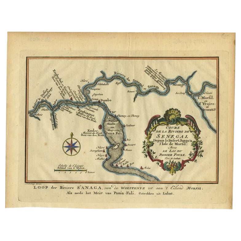
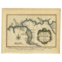
Antike Karte des Verlaufs des Sanaga- Flusses von Van Schley, 1747
Antike Karte mit dem Titel 'Cours de la Riviere de Senegal (..) - Loop der Riviere Sanaga (..)'. Originale antike Karte des Verlaufs des Sanaga-Flusses, der die Grenze zwischen Seneg...
Kategorie
Antik, 18. Jahrhundert, Landkarten
Materialien
Papier
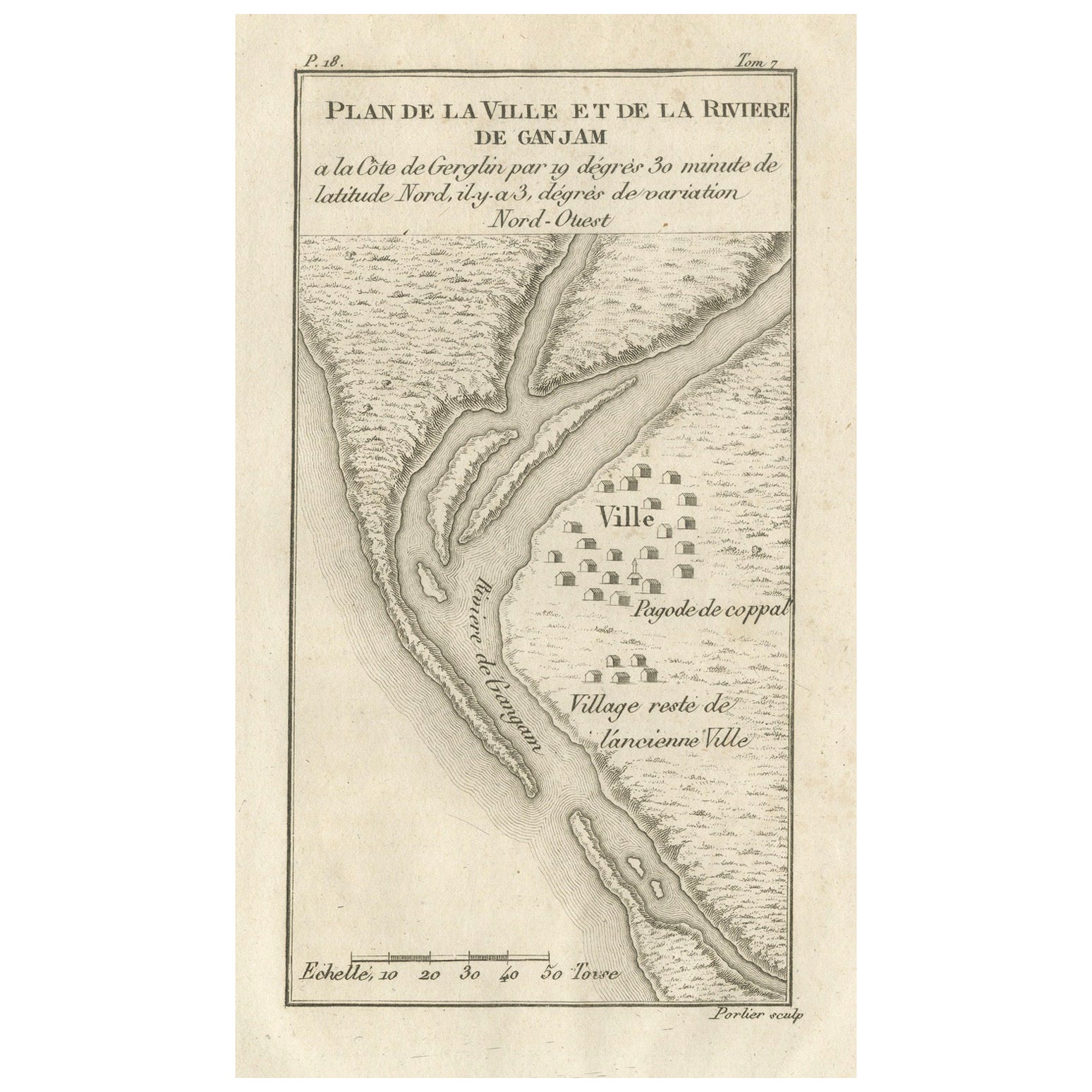
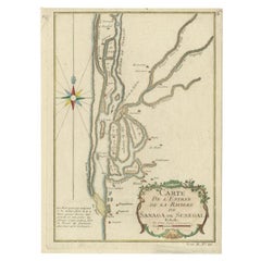
Plan der Townes und des Flusses von Ganjam, Indien - Antique French Map von Portier 1790
Plan der Townes und des Flusses von Ganjam, Indien - Antike französische Karte von Portier, um 1790
Dieser antike französische Stich zeigt einen detaillierten Plan der Stadt und des...
Kategorie
Antik, Spätes 18. Jahrhundert, Französisch, Landkarten
Materialien
Papier
Antike Karte des Tunquin River und der Bucht, Siam, 1757
Antike Karte mit dem Titel 'Carte du Cours de la Riviere de Tunquin Depuis Cacho jusqu'à la Mer'. Detaillierte Karte des Flusses und der Bucht von Tunquin, die sich im Norden bis zur...
Kategorie
Antik, 18. Jahrhundert, Französisch, Landkarten
Materialien
Papier

Das könnte Ihnen auch gefallen
Westafrikanische Westküste, Guinea und Sierra Leone: Eine Karte aus dem 18. Jahrhundert von Bellin
Von Jacques-Nicolas Bellin
Die Kupferstichkarte von Jacques Bellin mit dem Titel "Partie de la Coste de Guinee Dupuis la Riviere de Sierra Leona Jusquau Cap das Palmas", die die Küste von Guinea und Sierra Leo...
Kategorie
Antik, Mitte des 18. Jahrhunderts, Französisch, Landkarten
Materialien
Papier

398 € Verkaufspreis
20 % Rabatt
Westafrika mit dem Titel „Guinea Propria“: Eine handkolorierte Homann-Karte aus dem 18. Jahrhundert
Von Johann Baptist Homann
Dies ist eine seltene, reich kolorierte Kupferstichkarte von Afrika mit dem Titel "Guinea Propria, nec non Nigritiae vel Terrae Nigrorum Maxima Pars" von Johann Baptist Homann (1664-...
Kategorie
Antik, Mitte des 18. Jahrhunderts, Deutsch, Landkarten
Materialien
Papier

1.299 € Verkaufspreis
20 % Rabatt
Bellin Karte der Westküste Afrikas, 18. Jahrhundert; Guinea und Sierra Leone
Jacques Bellins Kupferstichkarte mit dem Titel "Partie de la Coste de Guinee Dupuis la Riviere de Sierra Leona Jusquau Cap das Palmas", die die Küste von Guinea und Sierra Leone in W...
Kategorie
1740er, Alte Meister, Landschaftsdrucke
Materialien
Gravur

398 € Verkaufspreis
20 % Rabatt
Handkolorierte Homann-Karte von Westafrika aus dem 18. Jahrhundert mit dem Titel „Guinea Propria“
Von Johann Baptist Homann
Dies ist eine seltene, reich kolorierte Kupferstichkarte von Afrika mit dem Titel "Guinea Propria, nec non Nigritiae vel Terrae Nigrorum Maxima Pars" von Johann Baptist Homann (1664-...
Kategorie
1740er, Sonstige Kunststile, Druckgrafiken und Multiples
Materialien
Gravur

1.299 € Verkaufspreis
20 % Rabatt
1640 Joan Bleau Karte mit dem Titel „Diocecese de rheims et le pais de rethel“, Eic.a011
1640 Joan Bleau Karte mit dem Titel
"Diocecese de rheims et le pais de rethel,"
Ric.a011
OAN BLAEU
Diocecese de Rheims, et le pais de Rethel.
Handkolorierter Kupfersti...
Kategorie
Antik, 17. Jahrhundert, Niederländisch, Landkarten
Materialien
Papier

Map Holy Land La Terre Sainte gravierte van Loon veröffentlicht N de Fer 1703 Französisch, Heiliges Land
La Terre Sainte, Das Heilige Land, Tiree Des Memoires De M.De.La Rue. Par N. de Fer. Geographe de Sa Majeste Catoliq et de Monseigneur le Dauphin. Avec Privil du Roi 1703
Detailli...
Kategorie
Antik, Anfang 1700, Französisch, Louis XIV., Landkarten
Materialien
Papier
