Objekte ähnlich wie Southern India Map, Deccan
Malabar, Nicolas Sanson, 1683

Möchten Sie mehr Bilder oder Videos?
Zusätzliche Bilder oder Videos von dem*der Anbieter*in anfordern
1 von 10
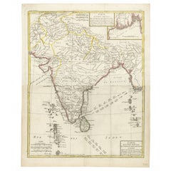
Southern India Map, Deccan
Malabar, Nicolas Sanson, 1683
440 €Einschließlich MwSt.
Angaben zum Objekt
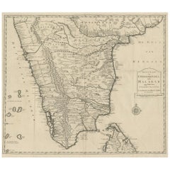
Southern India Map, Deccan
Malabar, Nicolas Sanson, 1683
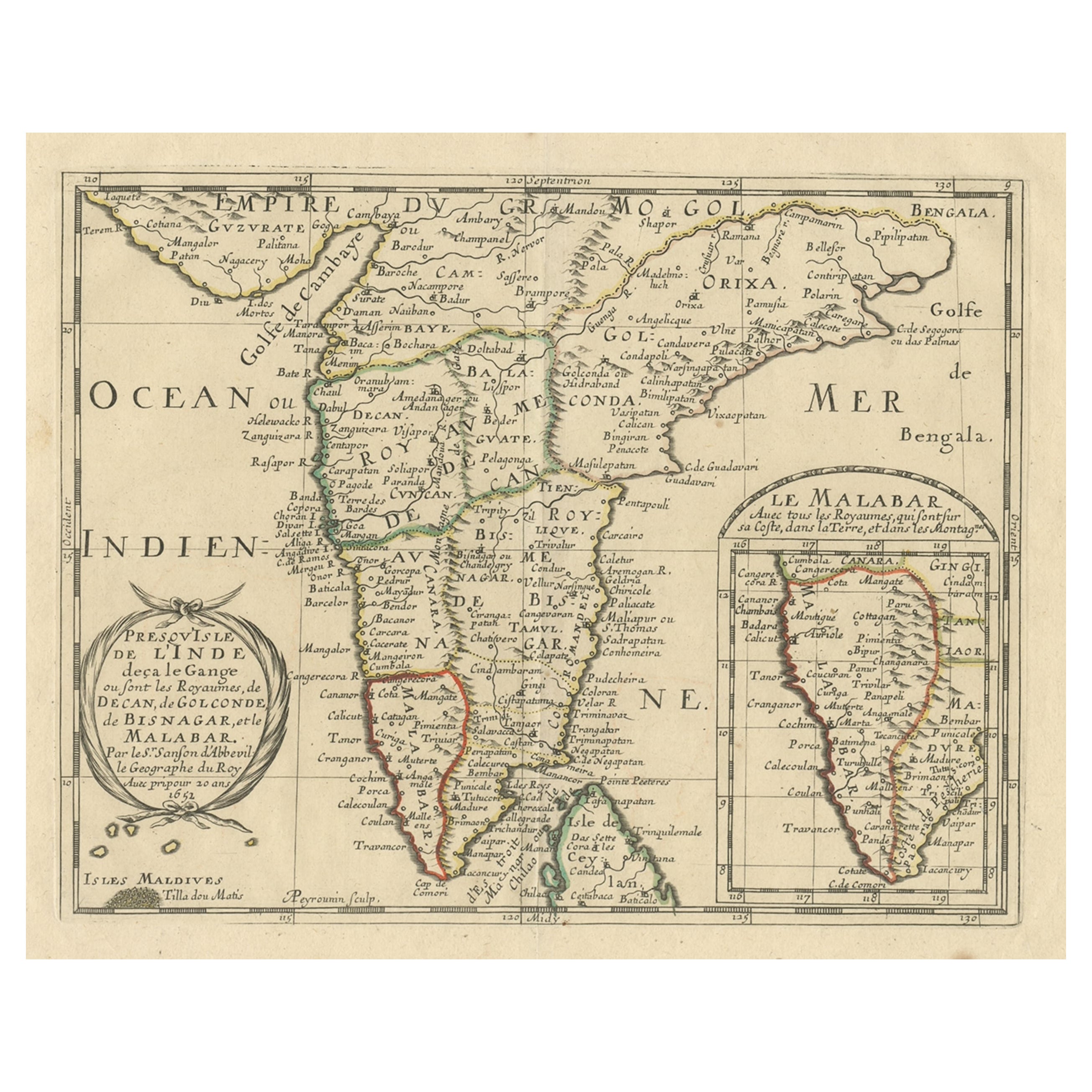
This engraved map depicts the Indian Peninsula, extending from Gujarat and the Bay of Bengal in the north to Cape Comorin and the northern tip of Sri Lanka in the south. Titled Presqu’Isle de l’Inde deça la Gange, it shows the major regions known to European geographers in the mid-17th century, including the Deccan, Golconda, Bisnagar, and the Malabar Coast.
The coastline is rendered with clarity and confidence, reflecting the strength of European coastal knowledge driven by maritime trade. Inland geography is more speculative, with mountain ranges and river systems presented according to contemporary geographic theory rather than direct observation. Despite this, the map successfully conveys the political and commercial structure of southern India as understood by Europeans during the early modern period.
An inset map at the lower right provides a focused view of the Malabar Coast, underscoring its importance within the Indian Ocean trading world. The Maldives are also included, with the northern atoll identified as “Tilla dou Matis,” highlighting European awareness of key maritime landmarks. Place names such as Golconda and Bisnagar reflect European adaptations of local political entities, some of which were already in decline or transformation by the time this map was issued.
The map was originally created by Nicolas Sanson in 1653 and later re-engraved for the first Dutch edition of his small-format atlas, published in Utrecht in 1683. The Dutch plates were engraved by Anthonie de Winter after Sanson’s Paris originals and are faithful copies rather than later reinterpretations. This example corresponds to that 1683 Utrecht issue, prior to later reworkings of the plate around 1700.
Printed on period paper, the map shows signs of age and use consistent with its origin from a bound atlas. It remains visually strong and is well suited for decorative framing, particularly for interiors focused on cartography, travel, or Asian history.
Condition report:
Engraved map on paper. Central vertical folds as issued, with overall age toning and light surface wear. Minor stains and handling marks visible. Margins present with some wear. Condition consistent with age and reflected in price.
Framing tips:
A wide mat is recommended to accommodate the folds and soften their appearance. Dark wood or black frames enhance the engraved detail and give the map strong visual presence. A floated mount can also work well if the folds are embraced as part of the map’s history.
Technique: Engraving
Maker: Nicolas Sanson d’Abbeville, re-engraved by Anthonie de Winter, Utrecht, 1683
- Maße:Höhe: 21,6 cm (8,51 in)Breite: 29,8 cm (11,74 in)Tiefe: 0,2 mm (0,01 in)
- Materialien und Methoden:Papier,Graviert
- Herkunftsort:
- Zeitalter:Spätes 17. Jahrhundert
- Herstellungsjahr:1683
- Zustand:Engraved map on paper. Central vertical folds as issued, with overall age toning and light surface wear. Minor stains and handling marks visible. Margins present with some wear. Condition consistent with age and reflected in price.
- Anbieterstandort:Langweer, NL
- Referenznummer:Anbieter*in: PCT-352281stDibs: LU3054348089232
Anbieterinformationen
5,0
Anerkannte Anbieter*innen
Diese renommierten Anbieter*innen sind führend in der Branche und repräsentieren die höchste Klasse in Sachen Qualität und Design.
Platin-Anbieter*in
Premium-Anbieter*innen mit einer Bewertung über 4,7 und 24 Stunden Reaktionszeit
Gründungsjahr 2009
1stDibs-Anbieter*in seit 2017
2.813 Verkäufe auf 1stDibs
Typische Antwortzeit: 1 Stunde
- VersandAngebot wird abgerufen …Versand von: Langweer, Niederlande
- Rückgabebedingungen
Einige Inhalte dieser Seite wurden automatisch übersetzt. Daher kann 1stDibs nicht die Richtigkeit der Übersetzungen garantieren. Englisch ist die Standardsprache dieser Website.
Mehr von diesem*dieser Anbieter*in
Alle anzeigen1705 Sanson-Karte von Südindien und Malabar mit eingelassener Karte
Titel: Sanson-Karte von Südindien und Malabar von 1705 mit einer Inspektionskarte
Beschreibung: Diese fein gestochene und wunderschön handkolorierte antike Karte, die 1705 veröffe...
Kategorie
Antik, Anfang 1700, Landkarten
Materialien
Papier

616 € Verkaufspreis
20 % Rabatt
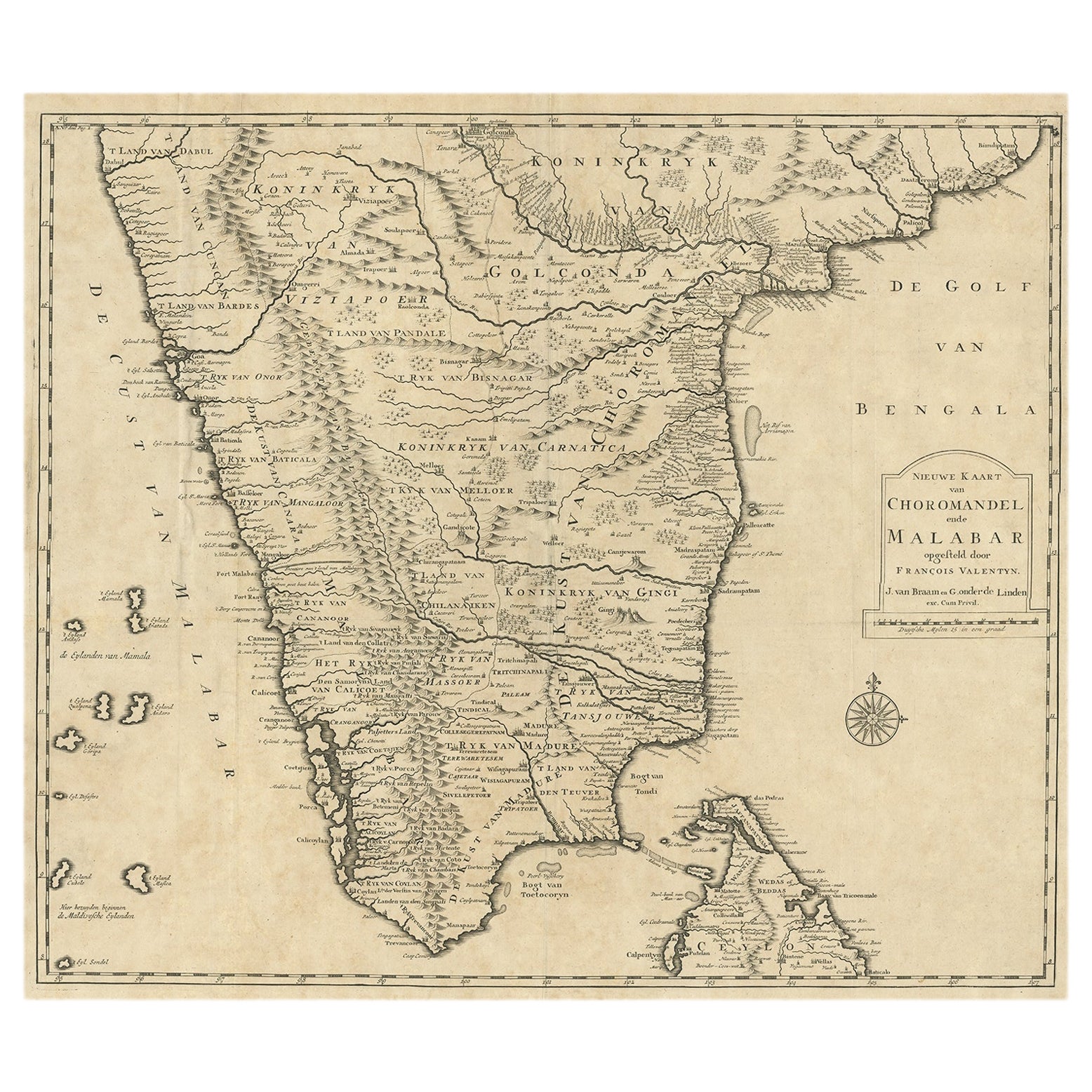
Map of Choromandel
Malabar, Incl Kerala, Tamil Nadu und Teil Sri Lankas, 1726
Antike Karte mit dem Titel 'Nieuwe kaart van Choromandel ende Malabar'.
Originale antike Karte von Südindien, die die Einflussgebiete der VOC dokumentiert. Dazu gehören Kerala, T...
Kategorie
Antik, 1720er, Niederländisch, Landkarten
Materialien
Papier
490 € Verkaufspreis
50 % Rabatt
Kostenloser Versand
Original Antike Karte aus Südindien, Nord Sri Lanka und Malabar, 1652
Antike Karte mit dem Titel 'Presqu'Isle de l'Inde deca le Gange (...)'.
Alte Karte, die den südlichen Teil Indiens, einschließlich des nördlichen Teils von Sri Lanka, zeigt. Mit ...
Kategorie
Antik, 1650er, Landkarten
Materialien
Papier

528 € Verkaufspreis
20 % Rabatt
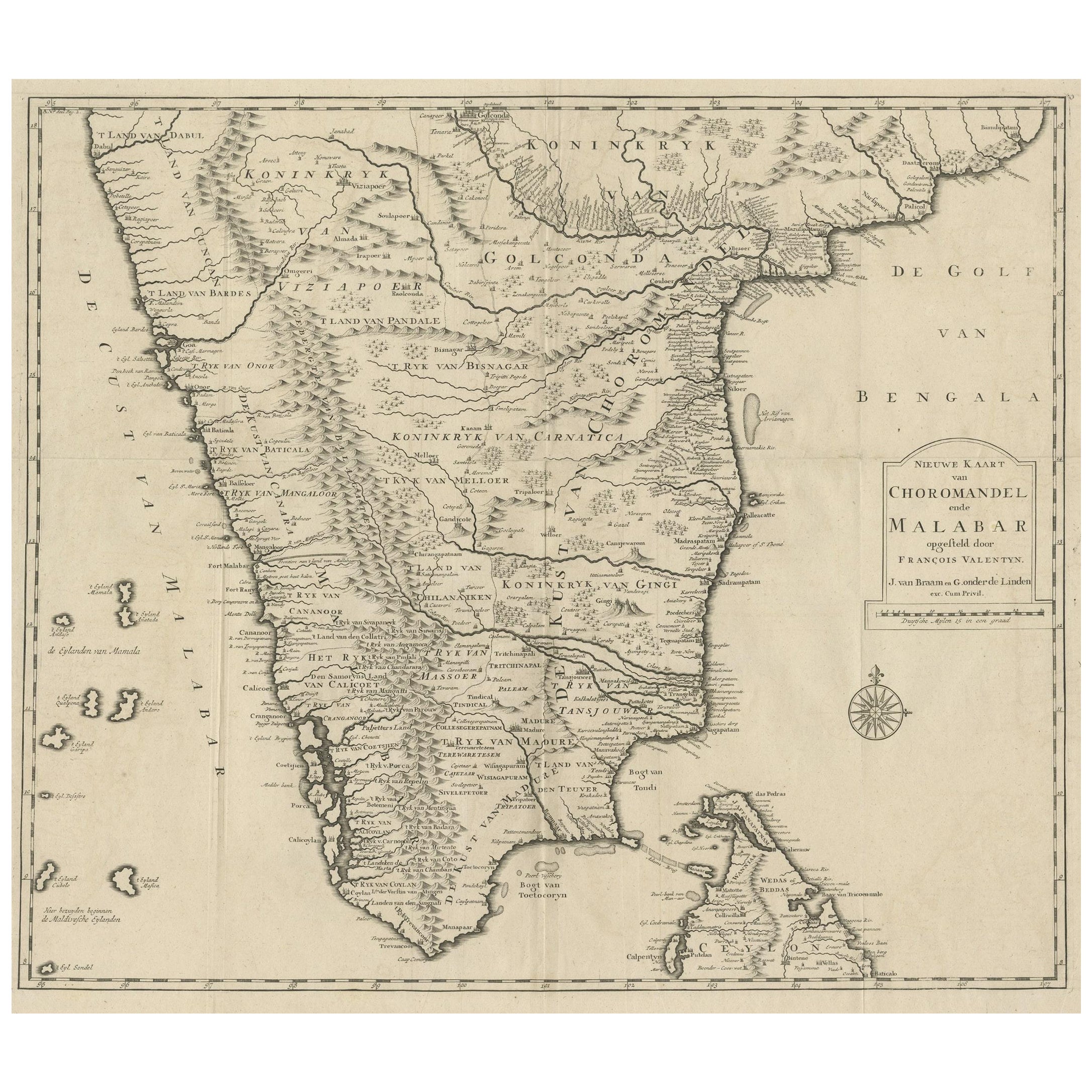
Alte Originalkarte von Chormandel
Malabar, Indien und Ceylon, jetzt Sri Lanka, 1726
Antike Karte mit dem Titel 'Nieuwe Kaart van Choromandel ende Malabar'.
Antike Karte, die den südlichen Teil Indiens und die Nordspitze von Ceylon, Sri Lanka, zeigt. Diese Karte st...
Kategorie
Antik, 1720er, Landkarten
Materialien
Papier
440 € Verkaufspreis
20 % Rabatt
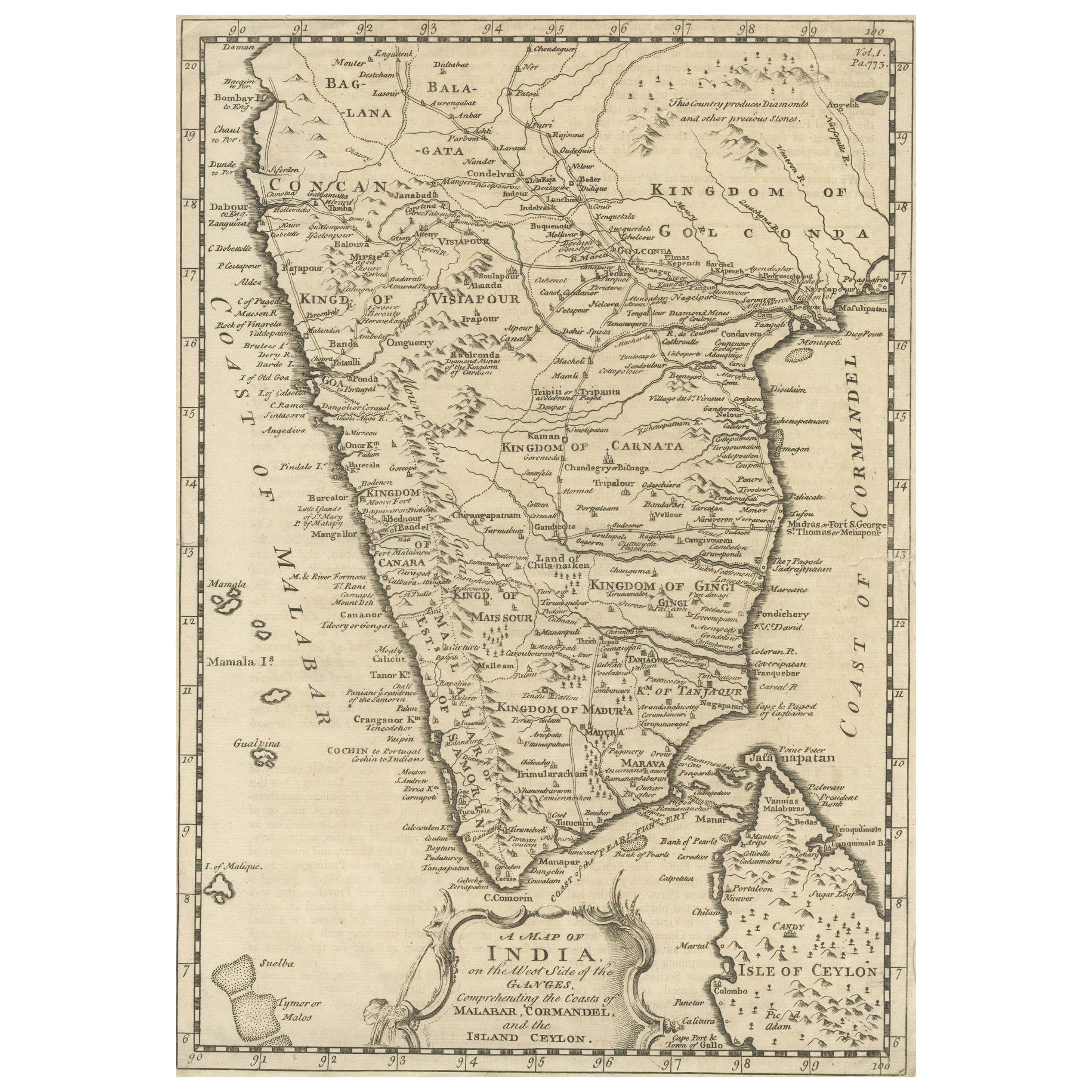
Detaillierte antike Karte von Südindien und dem größten Teil von Ceylon, 1744
Antike Karte mit dem Titel 'A Map of India on the west Side of the Ganges, comprehending the coasts of Malabar, Coromandel and the Island Ceylon'.
Karte von Südindien und dem grö...
Kategorie
Antik, 1740er, Landkarten
Materialien
Papier
352 € Verkaufspreis
20 % Rabatt
Karte von Indien und Ceylon mit einem Ausschnitt von Kalkutta und dem Ganges, von Bonne, 1780
Bei der angebotenen Karte handelt es sich um einen antiken Kupferstich von Indien und Ceylon (Sri Lanka), der von Rigobert Bonne (1727-1794), einem bekannten französischen Kartograph...
Kategorie
Antik, 1780er, Französisch, Landkarten
Materialien
Papier
Das könnte Ihnen auch gefallen
Antike Karte von Indien von Dower, um 1835
Schöne Karte von Indien
Gezeichnet und gestochen von J. Dower
Herausgegeben von Orr & Smith. C.1835
Ungerahmt.
Kostenloser Versand
Kategorie
Antik, 1830er, Englisch, Landkarten
Materialien
Papier

Karte Indiens – Originallithographie – 19. Jahrhundert
Map of India ist eine Original-Lithographie, die von einem Anonymer Graveur des 19. Jahrhunderts.
Gedruckt in der Reihe der "Frankreich pittoresk".
Unter dem Titel "France Pittor...
Kategorie
19. Jahrhundert, Moderne, Figurative Drucke
Materialien
Lithografie

Antike französische Karte von Asien, einschließlich China, Indonesien und Indien, 1783
Sehr schöne Karte von Asien. 1783 Dedie au Roy.
Zusätzliche Informationen:
Land der Herstellung: Europa
Zeitraum: 18. Jahrhundert Qing (1661 - 1912)
Zustand: Gesamtzustand B (Good U...
Kategorie
Antik, 18. Jahrhundert, Europäisch, Landkarten
Materialien
Papier

421 € Verkaufspreis
40 % Rabatt
Tabula Indiae Orientalis – Radierung von Frederick de Wit – 1680er Jahre
Von Frederick de Wit
Diese doppelseitige Radierung mit zeitgenössischem Kolorit trägt den Titel Tabula Indiae orientalis und wurde von dem Kartographen Frederick de Wit für den berühmten, um 1680 in Amst...
Kategorie
1680er, Moderne, Figurative Drucke
Materialien
Radierung

Map of the East Indies: Eine handkolorierte Karte aus dem 18. Jahrhundert von E. Bowen
Dies ist ein Original 18. Jahrhundert handkolorierte Karte mit dem Titel "An Accurate Map of the East Indies Exhibiting the Course of the European Trade...
Kategorie
Mitte des 18. Jahrhunderts, Alte Meister, Landschaftsdrucke
Materialien
Gravur

882 € Verkaufspreis
20 % Rabatt
Persien, Armenien, Natoliae et Arabiae Descriptio per Frederick deWit 1666 Karte
Karte von Persiae, Armeniae, Natoliae et Arabiae Descriptio per F de Wit 1688 Kupferstich aus: Atlas Contractus Orbis Terrarum Praecipuas ac Novissimas Complectens Tabulas. Amst...
Kategorie
1660er, Realismus, Landschaftsdrucke
Materialien
Gravur
