Objekte ähnlich wie Geological Map of South America by A.K. Johnston – Mountains and Valleys 1852


Möchten Sie mehr Bilder oder Videos?
Zusätzliche Bilder oder Videos von dem*der Anbieter*in anfordern
1 von 10
Geological Map of South America by A.K. Johnston – Mountains and Valleys 1852
260 €pro Objekt|Einschließlich MwSt.
Menge
Angaben zum Objekt
Geological Map of South America by A.K. Johnston – Mountains and Valleys 1852
This antique map titled "The Mountains, Table Lands, Plains
Valleys of South America" was produced by Alexander Keith Johnston and published in 1852 by William Blackwood
Sons in Edinburgh and London. It is Plate 9 from Johnston’s groundbreaking work *The Physical Atlas of Natural Phenomena*, a pioneering 19th-century publication that helped popularize thematic mapping and scientific cartography.
The map provides a physical representation of South America’s terrain, highlighting the dramatic topography of the Andes Mountains along the continent’s Pacific coast and the vast lowlands of the Amazon and La Plata river basins. Using subtle hand coloring, the map distinguishes mountain ranges, highland plateaus, valleys, and plains, rather than political borders. Light tan indicates elevated regions, green is used for valleys and lowland areas, while blue lines trace major rivers and coastlines.
Key natural features are clearly labeled, including the Cordillera of the Andes, the Brazilian Highlands, the Pampas, Patagonia, and Tierra del Fuego. The Amazon River and its tributaries dominate the northern interior, while a small inset diagram at lower right provides a vertical section showing comparative mountain heights across the continent from the Pacific to the Atlantic.
This map is of special interest due to its emphasis on natural geography over colonial divisions, which was a progressive perspective for the time. Johnston’s work sought to explain the physical world through data visualization, making it useful not only to geographers and scientists, but also to educators, students, and policymakers of the mid-19th century.
Alexander Keith Johnston (1804–1871), Geographer in Ordinary to Queen Victoria in Scotland, was renowned for his clarity, scientific rigor, and contribution to thematic mapping. His *Physical Atlas* is widely considered one of the most important scientific atlases ever published.
Condition and framing tips:
Very good condition with only minor age toning and faint foxing near the edges. The printed area remains clean and sharp.
Frame with a warm wood or black frame and use a cream, pale green, or light blue mat to enhance the natural hues and fine linework. Ideal for display in a study, office, or educational setting.
- Maße:Höhe: 34,5 cm (13,59 in)Breite: 27,4 cm (10,79 in)Tiefe: 0,2 mm (0,01 in)
- Materialien und Methoden:
- Herkunftsort:
- Zeitalter:
- Herstellungsjahr:1852
- Zustand:Very good condition. Light overall toning near the margins. The paper remains strong and well-preserved. Folding line as issued.
- Anbieterstandort:Langweer, NL
- Referenznummer:Anbieter*in: BG-13207-91stDibs: LU3054345387912
Anbieterinformationen
5,0
Anerkannte Anbieter*innen
Diese renommierten Anbieter*innen sind führend in der Branche und repräsentieren die höchste Klasse in Sachen Qualität und Design.
Platin-Anbieter*in
Premium-Anbieter*innen mit einer Bewertung über 4,7 und 24 Stunden Reaktionszeit
Gründungsjahr 2009
1stDibs-Anbieter*in seit 2017
2.836 Verkäufe auf 1stDibs
Typische Antwortzeit: 1 Stunde
- VersandAngebot wird abgerufen …Versand von: Langweer, Niederlande
- Rückgabebedingungen
Einige Inhalte dieser Seite wurden automatisch übersetzt. Daher kann 1stDibs nicht die Richtigkeit der Übersetzungen garantieren. Englisch ist die Standardsprache dieser Website.
Mehr von diesem*dieser Anbieter*in
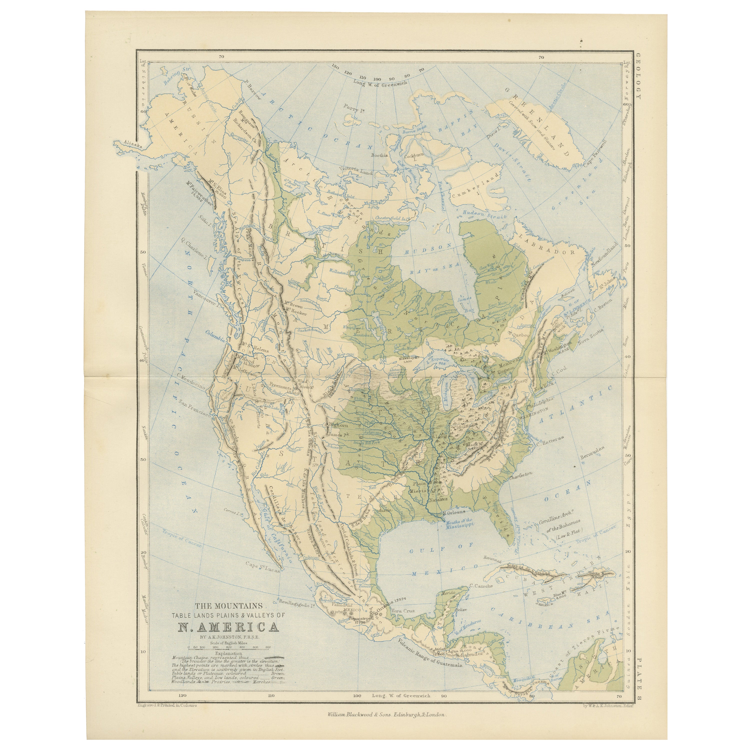
Alle anzeigenGeological Map of North America by A.K. Johnston – Mountains and Valleys 1852
Geological Map of North America by A.K. Johnston – Mountains and Valleys 1852
This finely detailed and beautifully shaded antique map titled "The Mountains, Table Lands, Plains & Va...
Kategorie
Antik, Mittleres 19. Jahrhundert, Schottisch, Drucke
Materialien
Papier
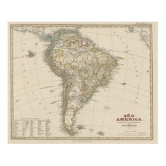
Antike Karte Südamerikas „North“ von A.K. Johnston, 1865
Antike Karte mit dem Titel 'Südamerika, nördliches Blatt'. Guayana, Ecuador, Brasilien, Bolivien, das Amazonasgebiet und mehr. Diese Karte stammt aus dem "Royal Atlas of Modern Geogr...
Kategorie
Antik, Mittleres 19. Jahrhundert, Landkarten
Materialien
Papier

Antike Karte Südamerikas von W. G. Blackie, 1859
Antike Karte mit dem Titel 'Südamerika'. Original antike Karte von Südamerika. Diese Karte stammt aus dem "Imperial Atlas of Modern Geography". Herausgegeben von W. G. Blackie, 1859.
Kategorie
Antik, Mittleres 19. Jahrhundert, Landkarten
Materialien
Papier

200 € Verkaufspreis
20 % Rabatt
Antike Karte von Südamerika von Johnston, 1844
Antitique-Karte mit dem Titel 'Südamerika'. Schöne original antike Landkarte von Südamerika. Diese Karte stammt aus "The National Atlas of Historical, Commercial and Political Geogra...
Kategorie
Antik, 19. Jahrhundert, Landkarten
Materialien
Papier

156 € Verkaufspreis
20 % Rabatt
Antike Karte Südamerikas, um 1840
Antike Karte mit dem Titel 'Südamerika'. Originale, antike Karte, die Südamerika darstellt. Mit Umrissfärbung. Quelle unbekannt, muss noch ermittelt werden. Artisten und Graveure: An...
Kategorie
Antik, 19. Jahrhundert, Landkarten
Materialien
Papier

58 € Verkaufspreis
20 % Rabatt
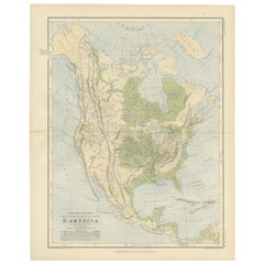
Antike Karte Südamerikas mit vielen Details, ca. 1859
Originale antike Karte mit dem Titel 'Süd-Amerika'. Schöne alte Karte von Südamerika, mit vielen Details und Legende.
Diese Karte stammt aus Stielers Handatlas, veröffentlicht um...
Kategorie
Antik, Mittleres 19. Jahrhundert, Landkarten
Materialien
Papier
464 € Verkaufspreis
20 % Rabatt
Das könnte Ihnen auch gefallen
Südamerika, östlicher Teil. Antike Atlas-Vintage-Karte
Der Jahrhundertatlas. Südamerika. Östlicher Teil
Originale antike Karte, 1903.
Inspektionskarte "Rio de Janeiro und Umgebung".
Zentrale Falte wie ausgestellt. Name und Nummer der K...
Kategorie
Frühes 20. Jahrhundert, Viktorianisch, Mehr Drucke
Materialien
Lithografie

Südamerika, Nord-West-Teil. Antike Atlas-Vintage-Karte
Der Jahrhundertatlas. Südamerika, nordwestlicher Teil'
Originale antike Karte, 1903.
Zentrale Falte wie ausgestellt. Name und Nummer der Karte sind auf der Rückseite aufgedruckt.
B...
Kategorie
Frühes 20. Jahrhundert, Viktorianisch, Mehr Drucke
Materialien
Lithografie

Karte von Sud-America (Karte von Südamerika) - Radierung mit handgezeichneten Umrissen
Karte von Südamerika, gestochen von Franz Pluth (Tschechisch, 1800-1871), aus dem Buch "Neueste Länder - und Völkerkunde, ein geographisches Lesebuch für alle Stände" von Linder, F. ...
Kategorie
1820er, Sonstige Kunststile, Mehr Drucke
Materialien
Papier, Druckertinte, Radierung

228 € Verkaufspreis
20 % Rabatt
Antike Karte Südamerikas in Roma-Rahmen
Antike Landkarte von Südamerika. Ausgestellt in einem neuen Roma-Rahmen mit Passepartout in Museumsqualität. Kundenspezifischer Rahmen aus Platin. Kein Druckdatum, aber die Zertifizi...
Kategorie
Antik, Spätes 19. Jahrhundert, Viktorianisch, Drucke
Materialien
Hartholz, Papier

230 € Verkaufspreis
30 % Rabatt
Carte du Bresil, antike gestochene Karte von Brasilien aus den 1860er Jahren
Carte du Bresil
Kupferstich mit Original-Umrisskolorit, um 1860, von Alexandre Vuillemin, veröffentlicht in Paris.
31cm x 41cm (Blatt)
21,5 cm x 31,5 cm (Bild)
Kategorie
Spätes 19. Jahrhundert, Viktorianisch, Mehr Drucke
Materialien
Lithografie

Original Antike Karte der westlichen Hemisphäre von Dower, circa 1835
Schöne Karte der westlichen Hemisphäre
Gezeichnet und gestochen von J. Dower
Herausgegeben von Orr & Smith. C.1835
Ungerahmt.
Kostenloser Versand
Kategorie
Antik, 1830er, Englisch, Landkarten
Materialien
Papier
