Artículos similares a Geological Map of Europe by A.K. Johnston – Mountains and Valleys 1852


¿Quieres más imágenes o vídeos?
Solicita imágenes o vídeos adicionales al vendedor
1 de 10
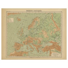
Geological Map of Europe by A.K. Johnston – Mountains and Valleys 1852
260 €por artículo|IVA incluido
Cantidad
Acerca del artículo
Geological Map of Europe by A.K. Johnston – Mountains and Valleys 1852
This elegant 1852 map titled "The Mountains, Table Lands, Plains
Valleys of Europe" was designed by the acclaimed Scottish geographer Alexander Keith Johnston and published by William Blackwood
Sons, Edinburgh and London. Issued as Plate 5 in Johnston’s pioneering work *The Physical Atlas of Natural Phenomena*, this map presents a physical topographic view of Europe with a focus on land elevation and terrain structure, rather than political borders.
Rendered in soft shades of beige, green, and blue, the map clearly delineates Europe’s major mountain ranges, including the Alps, Pyrenees, Carpathians, Apennines, and the Scandinavian Mountains. Valleys, upland plateaus, and lowlands are carefully shaded and labeled, giving a three-dimensional sense of the landscape. The careful use of hachuring and color gradients creates a tactile impression of Europe’s relief, from the Scottish Highlands to the Ural Mountains.
Rather than showing countries, the map categorizes the land by geological and geomorphological features. The title and key in the lower right explain the distinctions between highlands, tablelands, and low plains, emphasizing natural geography over human boundaries. This approach reflects the 19th-century scientific movement toward thematic cartography—maps made not to navigate or govern, but to understand physical phenomena.
Alexander Keith Johnston (1804–1871), Geographer in Ordinary to the Queen for Scotland, was one of the most respected mapmakers of the Victorian era. His *Physical Atlas* was a groundbreaking work in visual science, and among the first to systematically map climate, geology, hydrology, and landforms across the globe.
This plate is a beautifully executed example of early data visualization and remains highly relevant for collectors of antique scientific prints, students of European geography, or those seeking refined decorative maps for libraries, studies, or offices.
Condition and framing tips:
Very good antique condition with minor toning and slight edge wear. The print retains sharp detail and gentle original coloring. Best displayed in a black or walnut frame with a warm ivory or soft grey mat to highlight the topographic textures and historic typographic style. Ideal for natural history interiors or scholarly settings.
- Dimensiones:Altura: 27,4 cm (10,79 in)Anchura: 34,5 cm (13,59 in)Profundidad: 0,2 mm (0,01 in)
- Materiales y técnicas:
- Lugar de origen:
- Época:
- Fecha de fabricación:1852
- Estado:Very good condition. Light overall toning near the margins. The paper remains strong and well-preserved. Folding line as issued.
- Ubicación del vendedor:Langweer, NL
- Número de referencia:Vendedor: BG-13207-51stDibs: LU3054345386522
Sobre el vendedor
5,0
Vendedor reconocido
Estos prestigiosos vendedores son líderes del sector y representan el escalón más alto en cuanto a calidad y diseño de artículos.
Vendedor Platino
Vendedores premium con una calificación de +4,7 y tiempos de respuesta de 24 horas
Establecido en 2009
Vendedor de 1stDibs desde 2017
2810 ventas en 1stDibs
Tiempo de respuesta usual: <1 hora
- EnvíoRecuperando presupuesto…Envío desde: Langweer, Países Bajos
- Política de devolución
Partes de esta página se han traducido automáticamente. 1stDibs no puede garantizar la exactitud de las traducciones. El inglés es el idioma predeterminado de este sitio web.
Más de este vendedor
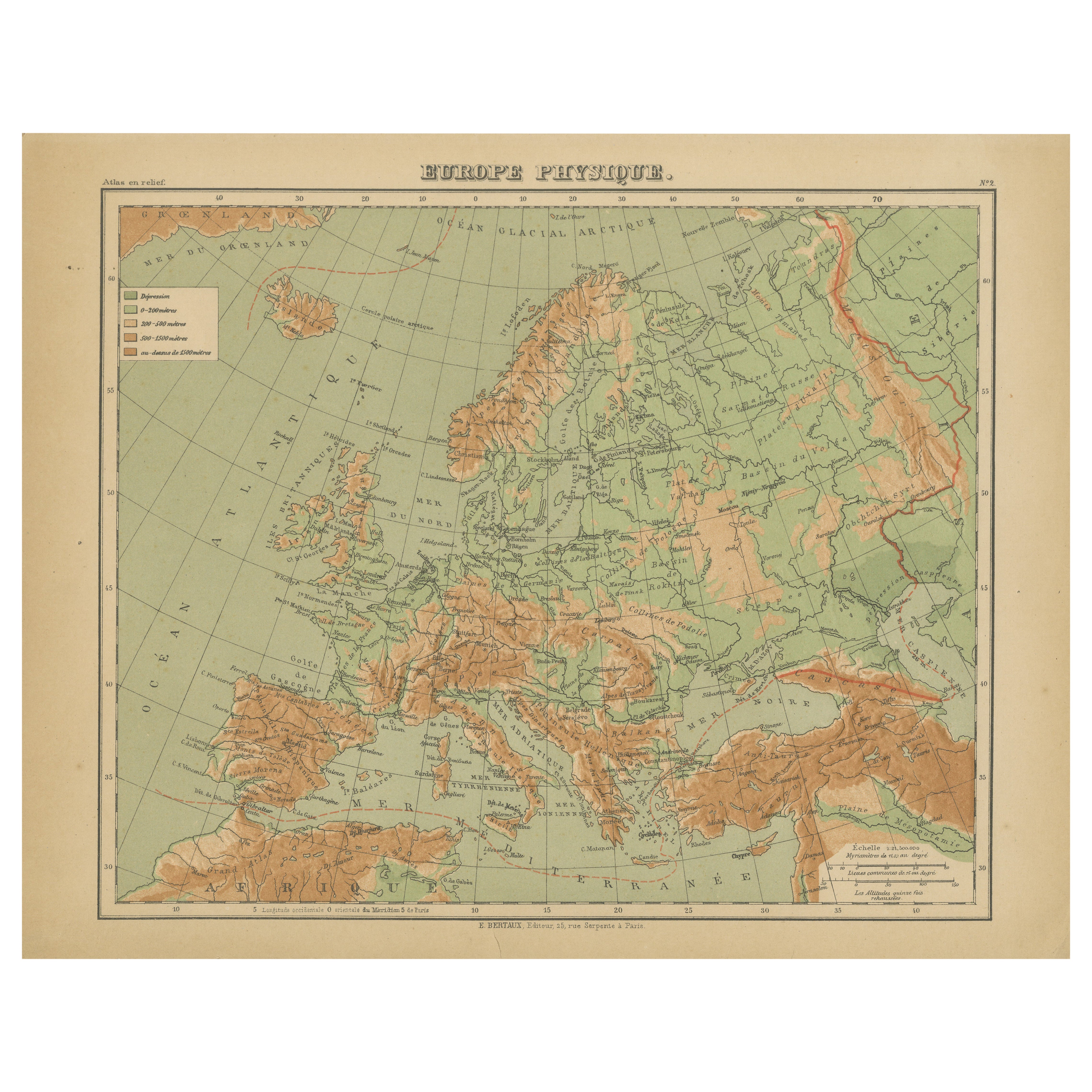
Ver todoMapa Atlas en relieve de Europa de Hachette - Antique French Map c.1883
Mapa antiguo de Europa - Mapa en relieve físico de Hachette, hacia 1883
Descripción:
Este mapa antiguo titulado "Europe Physique" fue publicado por Hachette en París hacia 1883 y pr...
Categoría
Antiguo, Fines del siglo XIX, Francés, Mapas
Materiales
Papel
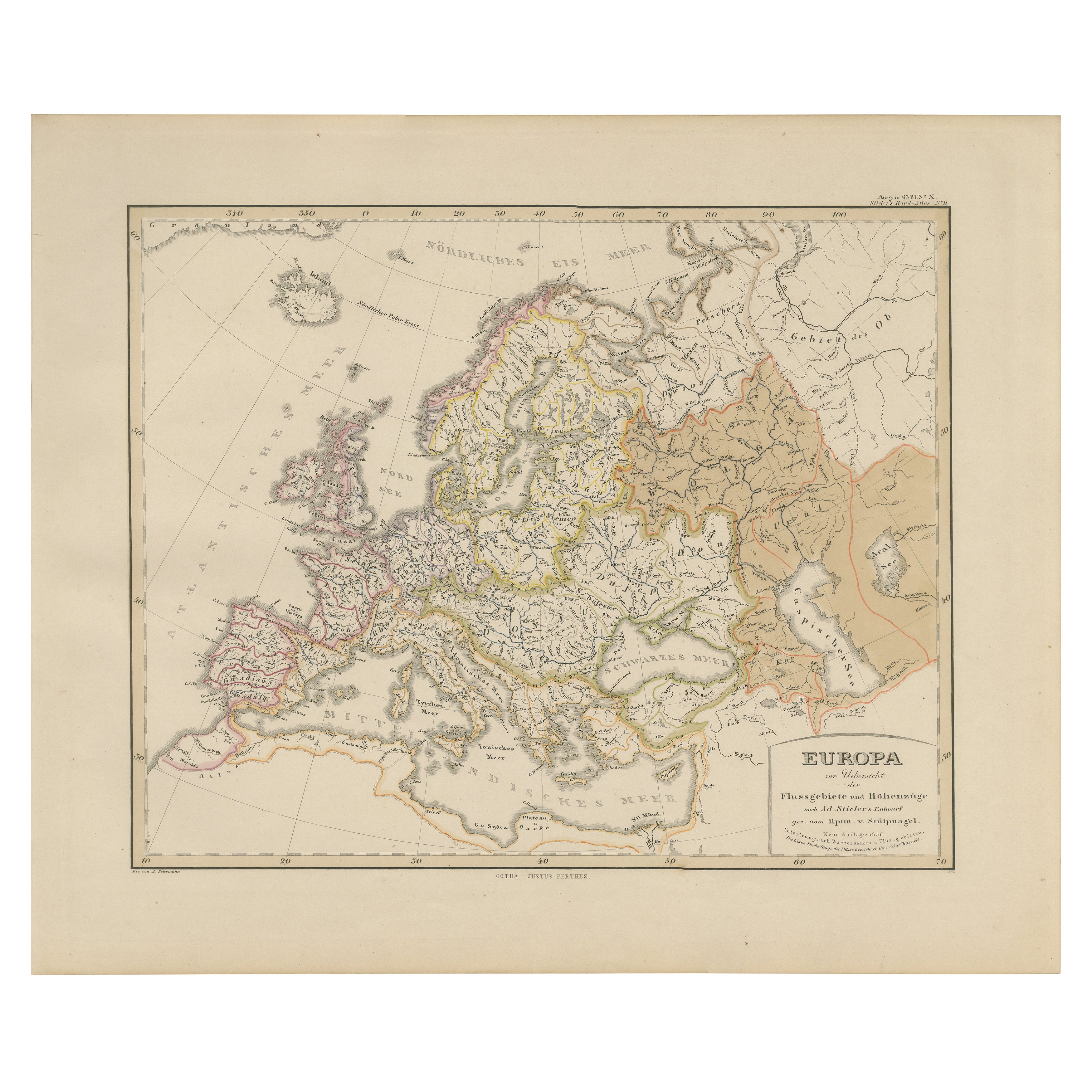
Mapa de Europa - Ríos, cuencas hidrográficas y elevación, publicado en 1857
Mapa de Europa - Ríos, cuencas hidrográficas y elevación 1857
Este hermoso grabado antiguo muestra Europa con sus sistemas fluviales y regiones de cuencas hidrográficas, titulado "E...
Categoría
Antiguo, Mediados del siglo XIX, Alemán, Mapas
Materiales
Papel
Mapa antiguo de Europa, 1903, con intrincados límites políticos y ricos detalles
Título: Mapa antiguo de Europa, 1903, con intrincados límites políticos y ricos detalles
Descripción:
Este mapa antiguo, titulado "Europa", es una obra maestra cartográfica finament...
Categoría
principios del siglo XX, Mapas
Materiales
Papel

Mapa antiguo de Europa por W. G. Blackie, 1859
Mapa antiguo titulado "Europa". Mapa antiguo original de Europa. Este mapa procede del "Atlas Imperial de Geografía Moderna". Publicado por W. G. Blackie, 1859.
Categoría
Antiguo, Mediados del siglo XIX, Mapas
Materiales
Papel

200 € Precio de venta
Descuento del 20 %
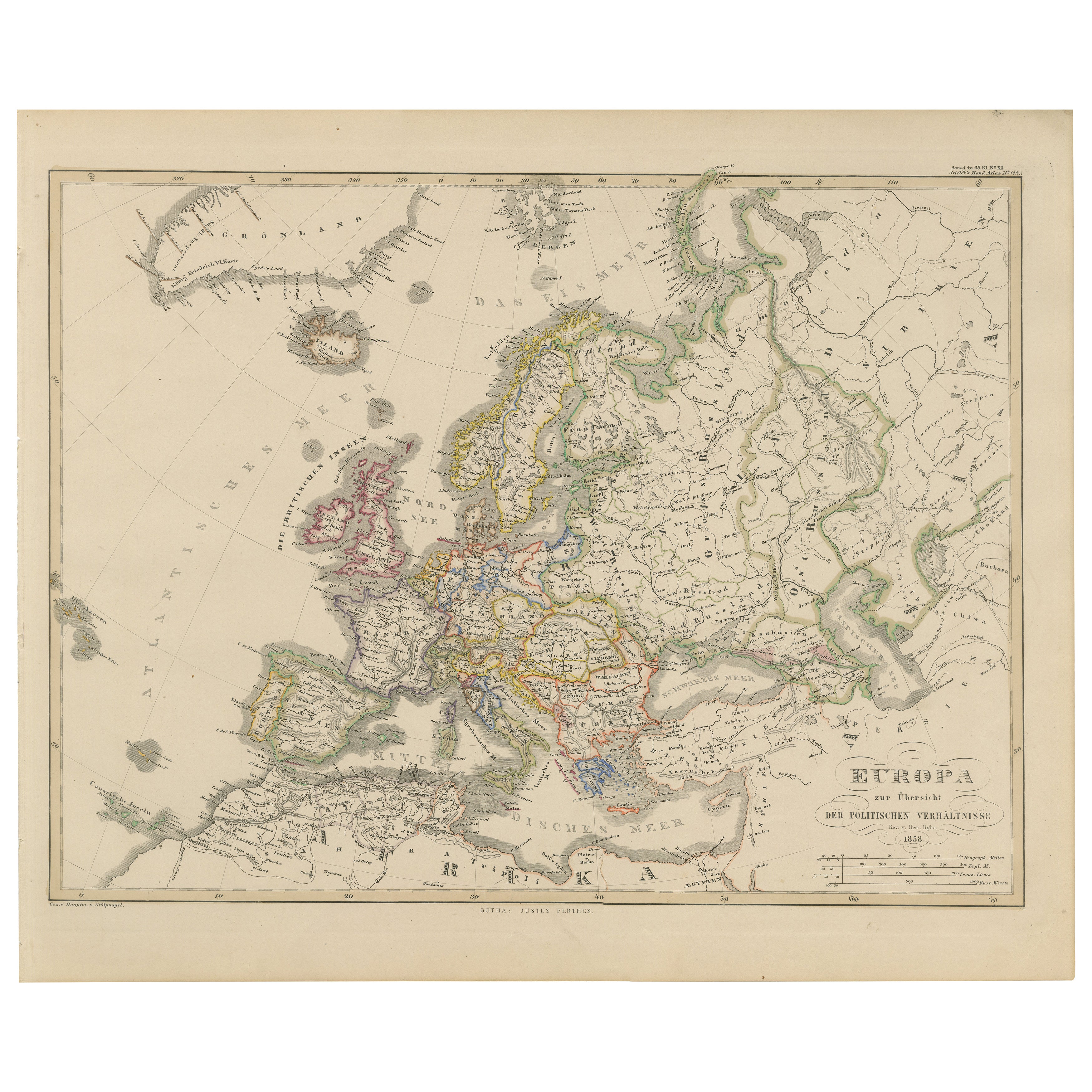
Mapa de Europa - Divisiones políticas y fronteras, publicado en 1858
Mapa de Europa - Divisiones políticas y fronteras 1858
Esta fina estampa antigua muestra a Europa con sus divisiones políticas titulada "Europa zur Übersicht der politischen Verhält...
Categoría
Antiguo, Mediados del siglo XIX, Alemán, Mapas
Materiales
Papel
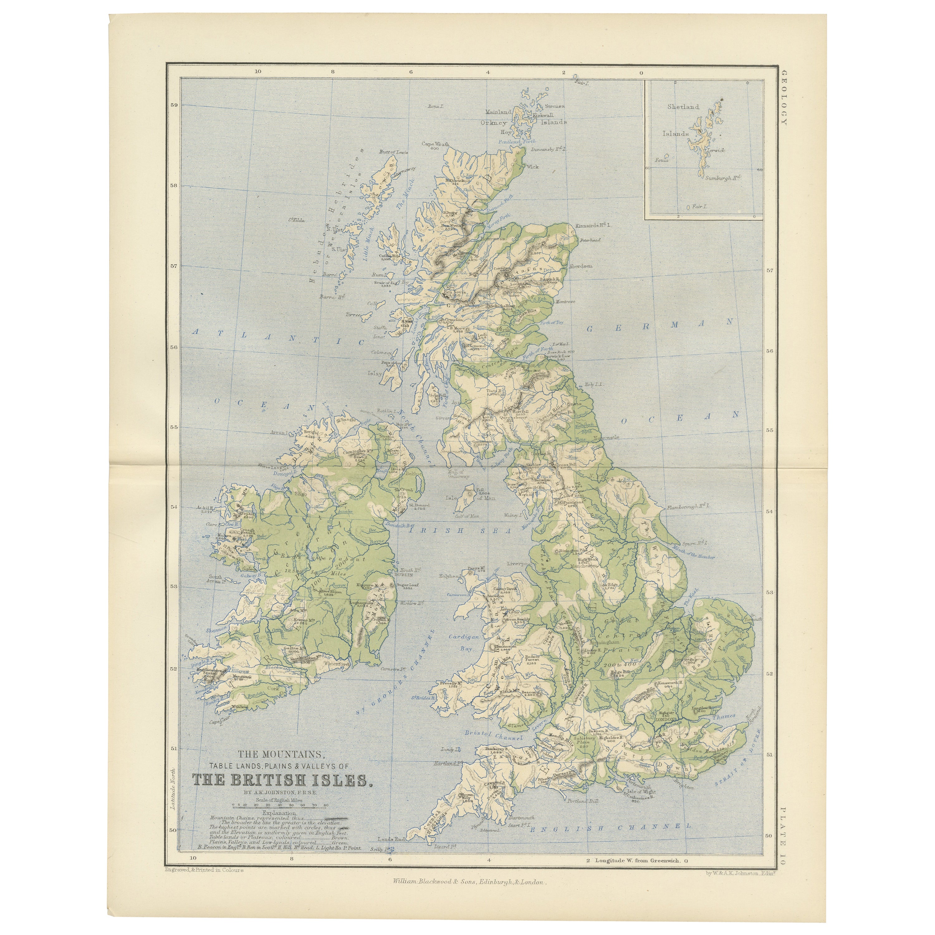
Geological Map of the British Isles by A.K. Johnston – Highlands
Valleys 1852
Geological Map of the British Isles by A.K. Johnston – Highlands & Valleys 1852
This antique topographic map titled "The Mountains, Table Lands, Plains & Valleys of the British Isle...
Categoría
Antiguo, Mediados del siglo XIX, Escocés, Impresiones
Materiales
Papel
También te puede gustar
Mapa de Europa, 1844
Mapa de Europa grabado por Olney en 1844, con más de 150 años de antigüedad. Color original a mano. Muestra el norte de Europa, Prusia y Alemania.
Mapa antiguo original sobre pa...
Categoría
Década de 1840, Más impresiones
Materiales
Tinta, Acuarela, Papel hecho a mano

Gran Mapa Antiguo Original de Europa por Sidney Hall, 1847
Gran mapa de Europa
Dibujado y grabado por Sidney Hall
Grabado en acero
Contorno de color original
Publicado por A & C Black. 1847
Sin enmarcar
Envío gratuito.
Categoría
Antiguo, Década de 1840, Escocés, Mapas
Materiales
Papel

Mapa original antiguo de Europa, Arrowsmith, 1820
Gran mapa de Europa
Dibujado bajo la dirección de Arrowsmith.
Grabado en plancha de cobre.
Publicado por Longman, Hurst, Rees, Orme, & Brown, 1820
Sin enmarcar.
Categoría
Antiguo, Década de 1820, Inglés, Mapas
Materiales
Papel

Gran mapa de Europa de 1798, en dos partes, coloreado a mano
Por Thomas Kitchin
Mapa de Europa impreso en dos hojas separadas del Nuevo Atlas Universal de Thomas Kitchin. Publicado en Londres por Laurie & Whittle, 1798. Grabados originales coloreados a mano en e...
Categoría
Década de 1790, Más arte
Materiales
Papel

1479 € Precio de venta
Descuento del 33 %
Mapa de Thomas Stackhouse de 1790, titulado "Rusia en Europa", Ric.a004
Mapa de Thomas Stackhouse de 1790, titulado
"Rusia en Europa"
Ric.a004
Stackhouse, Thomas
Rusia en Europa [mapa]
Londres: T. Stackhouse, 1783. Mapa. Grabado en cobre colorea...
Categoría
Antiguo, siglo XVII, Desconocido, Mapas
Materiales
Papel

Francia, Parte Norte. Mapa antiguo Century Atlas
El Atlas del Siglo. Francia, Parte Norte".
Mapa antiguo original, 1903.
Mapas en recuadro de "Francia en provincias" y "París y alrededores".
Pliegue central como se emitió. Nombre...
Categoría
principios del siglo XX, Victoriano, Más impresiones
Materiales
Litografía
