Artículos similares a Geological Map of North America by A.K. Johnston – Mountains and Valleys 1852


¿Quieres más imágenes o vídeos?
Solicita imágenes o vídeos adicionales al vendedor
1 de 12
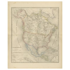
Geological Map of North America by A.K. Johnston – Mountains and Valleys 1852
260 €por artículo|IVA incluido
Cantidad
Acerca del artículo
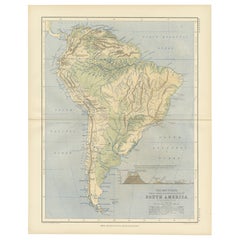
Geological Map of North America by A.K. Johnston – Mountains and Valleys 1852
This finely detailed and beautifully shaded antique map titled "The Mountains, Table Lands, Plains
Valleys of North America" was created by the noted Scottish geographer Alexander Keith Johnston and published in 1852 by William Blackwood
Sons in Edinburgh and London. It was issued as Plate 8 in Johnston’s groundbreaking *Physical Atlas of Natural Phenomena*, one of the earliest and most influential works of thematic cartography in the 19th century.
The map presents the topographic structure of the North American continent, emphasizing physical geography over political borders. Using a delicate yet effective palette of hand-applied color, it distinguishes between mountainous regions, plateaus, plains, and river valleys. Green areas denote lowlands and river basins, while tan and brown areas indicate elevated terrain, such as mountain ranges and high plateaus.
Key geographical features are precisely labeled, including the Rocky Mountains, Appalachian Mountains, Sierra Nevada, Great Basin, Canadian Shield, and Mississippi River Valley. The map covers all of North America, including Canada, the United States, Mexico, Central America, the Caribbean, and Greenland, as well as the Arctic archipelagos. Major tablelands such as those of Mexico and the Colorado Plateau are also clearly outlined, demonstrating the complexity of North America's geological structure.
What sets this map apart is its educational clarity and scientific intent. Johnston’s work was intended to inform and enlighten readers about the structure of the natural world, making this a valuable piece not just for collectors of antique maps but also for educators, environmental historians, and interior designers seeking historically meaningful artwork.
Alexander Keith Johnston (1804–1871) was a pioneering figure in British cartography. As Geographer in Ordinary to Queen Victoria for Scotland, he advanced the visual communication of scientific data through maps. His *Physical Atlas* remains a landmark publication in the history of science and cartography.
Condition and framing tips:
Very good condition with light age toning, original centerfold, and faint foxing at edges. Printed area clean and well-preserved. Frame in dark wood or black with a soft ivory or sage green mat to enhance the earthy palette and highlight the map's elegant detailing. Perfect for libraries, offices, or natural history-themed interiors.
- Dimensiones:Altura: 34,5 cm (13,59 in)Anchura: 27,4 cm (10,79 in)Profundidad: 0,2 mm (0,01 in)
- Materiales y técnicas:
- Lugar de origen:
- Época:
- Fecha de fabricación:1852
- Estado:Very good condition. Light overall toning near the margins. The paper remains strong and well-preserved. Folding line as issued.
- Ubicación del vendedor:Langweer, NL
- Número de referencia:Vendedor: BG-13207-81stDibs: LU3054345386722
Sobre el vendedor
5,0
Vendedor reconocido
Estos prestigiosos vendedores son líderes del sector y representan el escalón más alto en cuanto a calidad y diseño de artículos.
Vendedor Platino
Vendedores premium con una calificación de +4,7 y tiempos de respuesta de 24 horas
Establecido en 2009
Vendedor de 1stDibs desde 2017
2809 ventas en 1stDibs
Tiempo de respuesta usual: 1 hora
- EnvíoRecuperando presupuesto…Envío desde: Langweer, Países Bajos
- Política de devolución
Partes de esta página se han traducido automáticamente. 1stDibs no puede garantizar la exactitud de las traducciones. El inglés es el idioma predeterminado de este sitio web.
Más de este vendedor
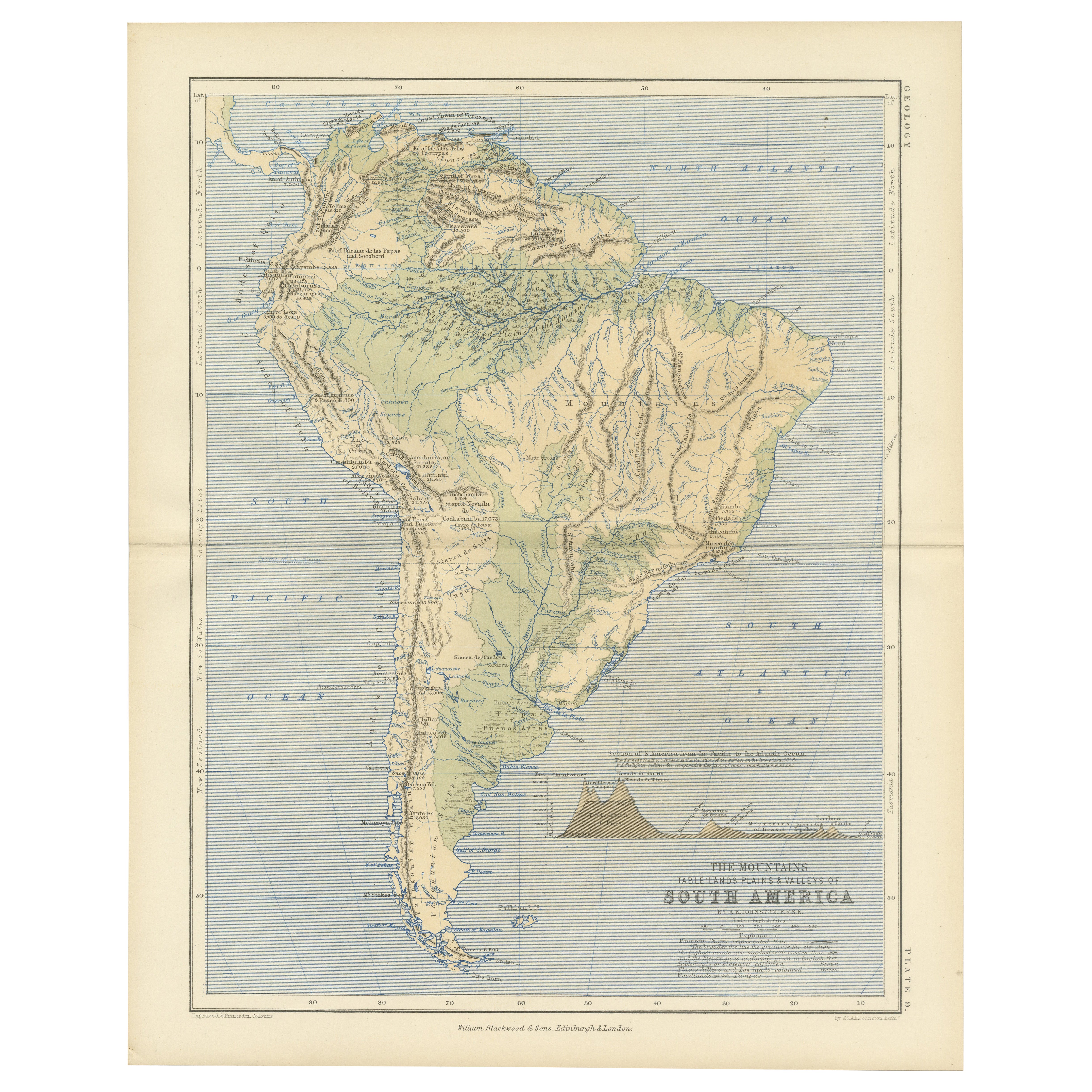
Ver todoGeological Map of South America by A.K. Johnston – Mountains and Valleys 1852
Geological Map of South America by A.K. Johnston – Mountains and Valleys 1852
This antique map titled "The Mountains, Table Lands, Plains & Valleys of South America" was produced by...
Categoría
Antiguo, Mediados del siglo XIX, Escocés, Impresiones
Materiales
Papel
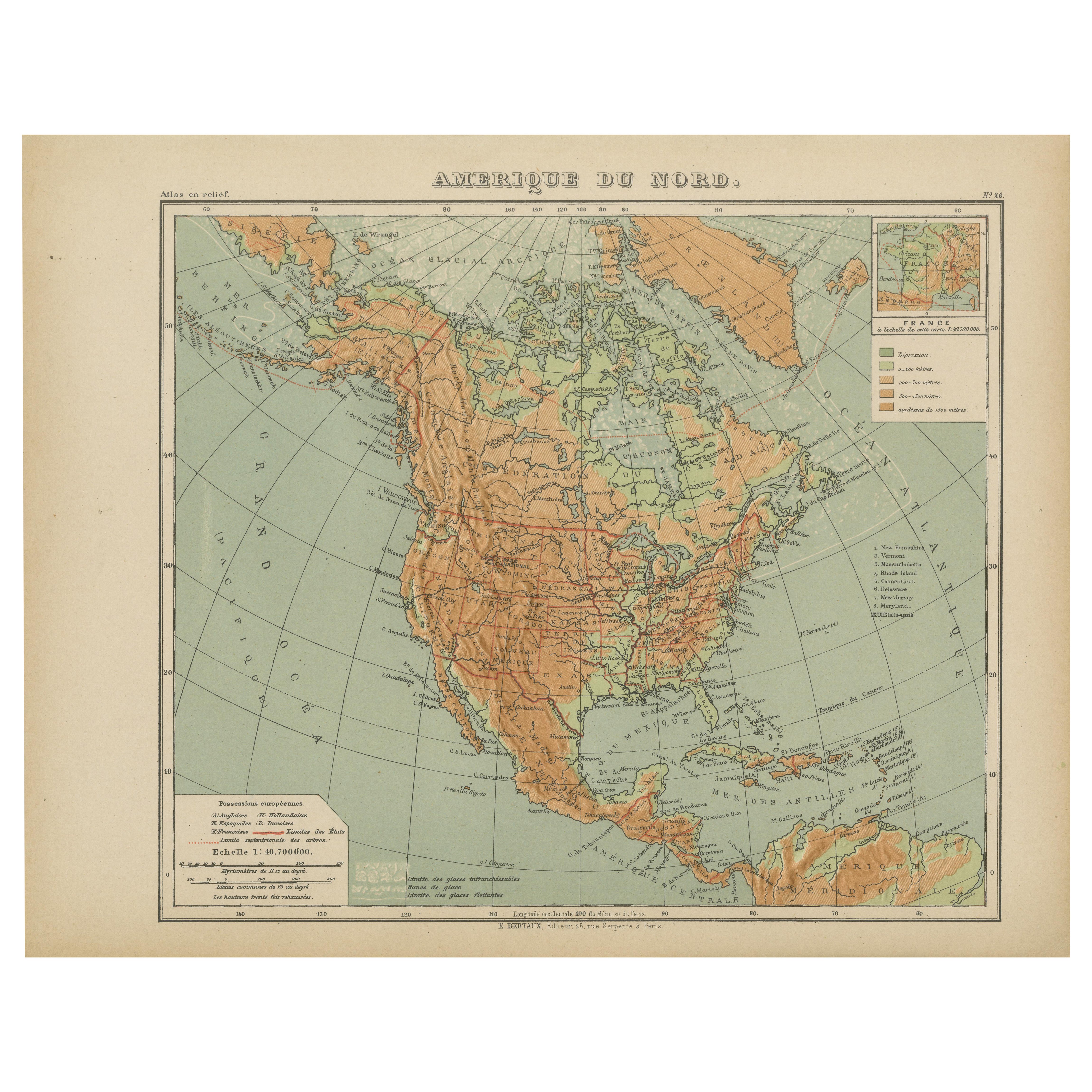
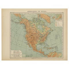
Mapa antiguo de América del Norte - Mapa en relieve físico de Hachette c.1883
Mapa antiguo de América del Norte - Mapa en relieve físico de Hachette c.1883
Descripción:
Este mapa antiguo titulado "Amérique du Nord" fue publicado hacia 1883 por E. Hachette en ...
Categoría
Antiguo, Fines del siglo XIX, Francés, Mapas
Materiales
Papel
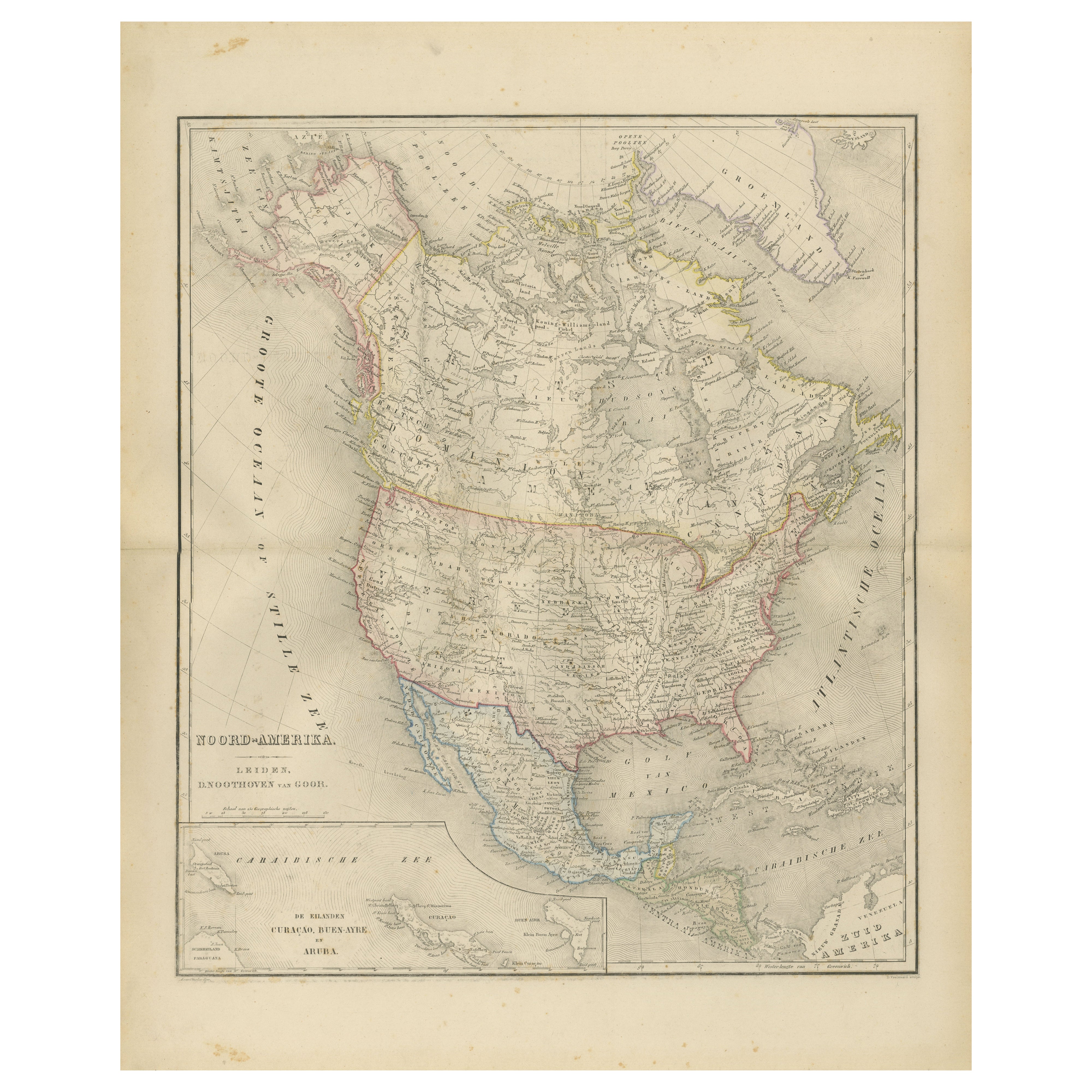
Mapa de América del Norte con EE.UU., Canadá y México - Nieuwe Hand-Atlas, 1876
Mapa de América del Norte con EE.UU., Canadá y México - Nieuwe Hand-Atlas, 1876
Este mapa del siglo XIX de "Noord-Amerika", finamente grabado y publicado en 1876 por D. Noothoven va...
Categoría
Antiguo, Década de 1870, Holandés, Mapas
Materiales
Papel
Mapa antiguo de América del Norte por A
C. Black, 1870
Mapa antiguo titulado "América del Norte". Mapa antiguo original de América del Norte. Este mapa procede del "Atlas General del Mundo de Black". Publicado por A & C. Black, 1870.
Categoría
Antiguo, Fines del siglo XIX, Mapas
Materiales
Papel

220 € Precio de venta
Descuento del 20 %
Mapa antiguo de América del Norte por Johnston, 1882
Por Alexander Keith Johnston
Mapa antiguo titulado "América del Norte".
Antiguo mapa de América del Norte. Este mapa procede de "El Real Atlas de Geografía Moderna, que expone, en una serie de mapas totalmente...
Categoría
Antiguo, siglo XIX, Mapas
Materiales
Papel

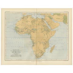
Geological Map of Africa by A.K. Johnston – Mountains and Valleys 1852
Geological Map of Africa by A.K. Johnston – Mountains and Valleys 1852
This antique map titled "The Mountains, Table Lands, Plains & Valleys of Africa" was produced by the distingui...
Categoría
Antiguo, Mediados del siglo XIX, Escocés, Impresiones
Materiales
Papel
También te puede gustar
América del Norte. Atlas del Siglo mapa antiguo vintage
El Atlas del Siglo. América del Norte
Mapa antiguo original, 1903.
Pliegue central como se emitió. Nombre y número del mapa impresos en las esquinas del reverso.
Hoja de 40 cm por ...
Categoría
principios del siglo XX, Victoriano, Más impresiones
Materiales
Litografía

Mapa original antiguo de América del Norte por Dower, hacia 1835
Bonito mapa de América del Norte
Dibujado y grabado por J.Dower
Publicado por Orr & Smith. C.1835
Sin enmarcar.
Envío gratuito
Categoría
Antiguo, Década de 1830, Inglés, Mapas
Materiales
Papel

Gran Mapa Vintage Original de América del Norte, circa 1920
Gran mapa de América del Norte
Color original. Buen estado
Publicado por Alexander Gross
Sin enmarcar.
Categoría
Vintage, Década de 1920, Inglés, Eduardiano, Mapas
Materiales
Papel

1864 Mapa de América del Norte, Mapa antiguo coloreado a mano, por Adolphe Hippolyte Dufour
Se ofrece un mapa de América del Norte titulado Amerique du Nord de 1864. Este raro mapa mural, publicado por separado, fue realizado por Adolphe Hippolyte Dufour. Este mapa incluye ...
Categoría
Antiguo, Década de 1860, Francés, Mapas
Materiales
Papel

Mapa original antiguo de los Estados Unidos de América por Dower, hacia 1835
Bonito mapa de EEUU
Dibujado y grabado por J.Dower
Publicado por Orr & Smith. C.1835
Sin enmarcar.
Envío gratuito
Categoría
Antiguo, Década de 1830, Inglés, Mapas
Materiales
Papel

Mapa grande de América del Norte y sus territorios de 1848
Enmarcado 1848 S. Augustus y Mitchell, Filadelfia , PA Mapa de Norteamérica y sus territorios.
Con Estados Unidos, Canadá (Territorio Británico) y Territorios Mexicanos.
Como se en...
Categoría
Antiguo, Década de 1840, Estadounidense, clásico estadounidense, Mapas
Materiales
Vidrio, Madera, Papel
