Artículos similares a Religious Belief Map by A.K. Johnston – Moral and Statistical Chart 1852


¿Quieres más imágenes o vídeos?
Solicita imágenes o vídeos adicionales al vendedor
1 de 11
Religious Belief Map by A.K. Johnston – Moral and Statistical Chart 1852
260 €por artículo|IVA incluido
Cantidad
Acerca del artículo
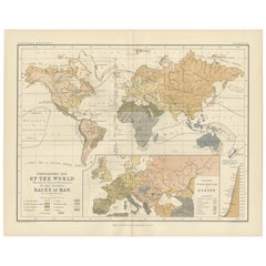
Religious Belief Map by A.K. Johnston – Moral and Statistical Chart 1852
This antique chart titled "Moral
Statistical Chart Showing the Distribution of Man According to Prevailing Forms of Religious Belief
the Proportionate Number of Each Creed in the Principal States of the Globe" was created by Alexander Keith Johnston and published in 1852 by William Blackwood
Sons in Edinburgh and London. Issued as Plate 18 in Johnston’s *Physical Atlas of Natural Phenomena*, this map is a rare and historically significant early attempt to visualize global religious demographics.
The world is color-coded to reflect the dominant religions in various regions, including Christianity (with Roman Catholic, Greek Orthodox, and Protestant branches distinguished), Islam (Sunni and Shiite), Buddhism, Brahmanism (Hinduism), Judaism, and areas broadly labeled as "Heathen" or "Other Faiths," in accordance with 19th-century terminology. The color-coded legend to the lower right includes estimated numbers of adherents for each group, offering a numerical context to the geographic distribution.
Each country or empire is labeled with estimates of its religious composition and population size, from the British Isles and Ottoman Empire to China, Russia, India, and the Americas. The chart reflects not only religious spread, but also the political-religious affiliations of empires and colonial powers during the mid-19th century.
At the bottom of the chart is a diagram titled “Progress of Education,” using bar graphs to compare levels of literacy and schooling across nations—an early example of combining moral and statistical inquiry through cartography. Countries such as Prussia, Scotland, and Saxony rank highest in this education index, while others show much lower rates of public instruction, as interpreted from available data at the time.
Alexander Keith Johnston (1804–1871), Geographer in Ordinary to Queen Victoria in Scotland, was a pioneer in thematic and scientific cartography. His *Physical Atlas* was one of the first atlases to integrate human, environmental, and physical data into visually compelling and educational maps.
This plate is of particular interest to collectors of religious history, antique data visualization, and 19th-century worldviews. It reflects the empirical spirit of the age, while also serving as a historical document of cultural perspectives from a European scientific lens.
Condition and framing tips:
Very good antique condition with some mild age toning and a clean printed surface. Original centerfold as issued. Frame in a dark or neutral wood with a cream or parchment mat to complement the subtle pastel palette and enhance legibility. Ideal for display in a study, library, or historical institution.
- Dimensiones:Altura: 27,4 cm (10,79 in)Anchura: 34,5 cm (13,59 in)Profundidad: 0,2 mm (0,01 in)
- Materiales y técnicas:
- Lugar de origen:
- Época:
- Fecha de fabricación:1852
- Estado:Very good condition. Light overall toning near the margins. The paper remains strong and well-preserved. Folding line as issued.
- Ubicación del vendedor:Langweer, NL
- Número de referencia:Vendedor: BG-13207-181stDibs: LU3054345393582
Sobre el vendedor
5,0
Vendedor reconocido
Estos prestigiosos vendedores son líderes del sector y representan el escalón más alto en cuanto a calidad y diseño de artículos.
Vendedor Platino
Vendedores premium con una calificación de +4,7 y tiempos de respuesta de 24 horas
Establecido en 2009
Vendedor de 1stDibs desde 2017
2800 ventas en 1stDibs
Tiempo de respuesta usual: <1 hora
- EnvíoRecuperando presupuesto…Envío desde: Langweer, Países Bajos
- Política de devolución
Partes de esta página se han traducido automáticamente. 1stDibs no puede garantizar la exactitud de las traducciones. El inglés es el idioma predeterminado de este sitio web.
Más de este vendedor
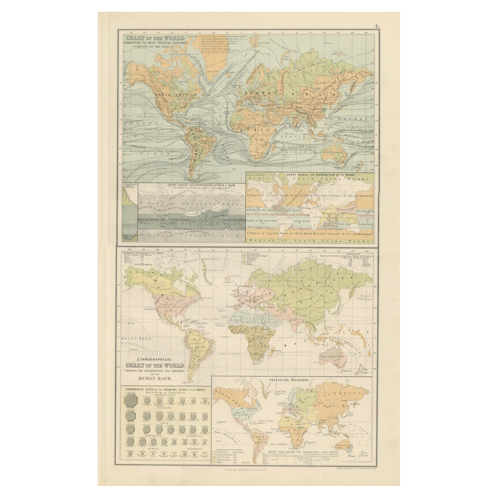
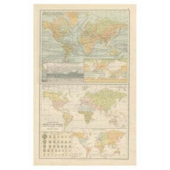
Ver todoMapa antiguo de las religiones del mundo por Johnston
1854
Mapa antiguo titulado "Cuadro moral y estadístico de la distribución geográfica del hombre según las creencias religiosas". Raro mapa temático de gran tamaño sobre la distribución de...
Categoría
Antiguo, Mediados del siglo XIX, Mapas
Materiales
Papel

780 € Precio de venta
Descuento del 35 %
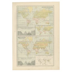
Ethnographic Map of the World by A.K. Johnston – Races of Man Chart 1852
Ethnographic Map of the World by A.K. Johnston – Races of Man Chart 1852
This antique map titled "Ethnographic Map of the World Showing the Present Distribution of the Leading Races...
Categoría
Antiguo, Mediados del siglo XIX, Escocés, Impresiones
Materiales
Papel
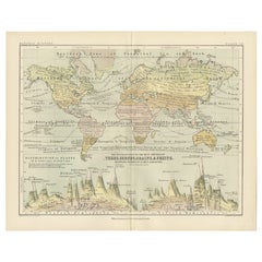
Cartas antiguas del mundo - Características físicas y mapa etnográfico, 1884
Cartas antiguas del mundo - Características físicas y mapa etnográfico, 1884
Descripción:
Esta fascinante lámina doble de la Edición Nueva y Revisada del Atlas General del Mundo de ...
Categoría
Antiguo, Década de 1880, Escocés, Mapas
Materiales
Papel
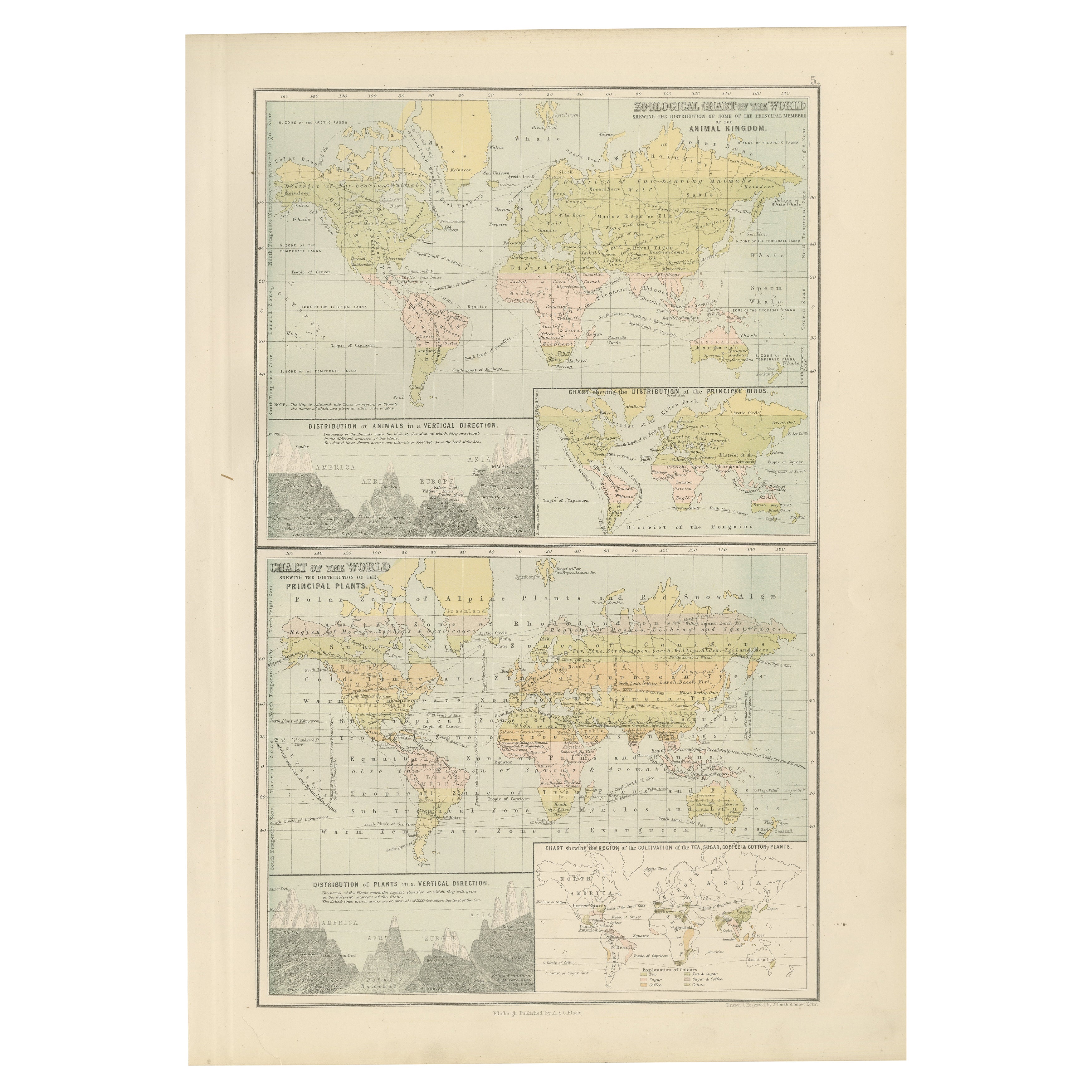
Antiguo Mapa Zoológico y Botánico del Mundo - Mapa Decorativo, 1884
Cartas zoológicas y botánicas antiguas del mundo - Atlas de Black, 1884
Esta lámina doble de la Edición Nueva y Revisada del Atlas General del Mundo de Black, publicado en Edimburgo...
Categoría
Antiguo, Década de 1880, Escocés, Mapas
Materiales
Papel
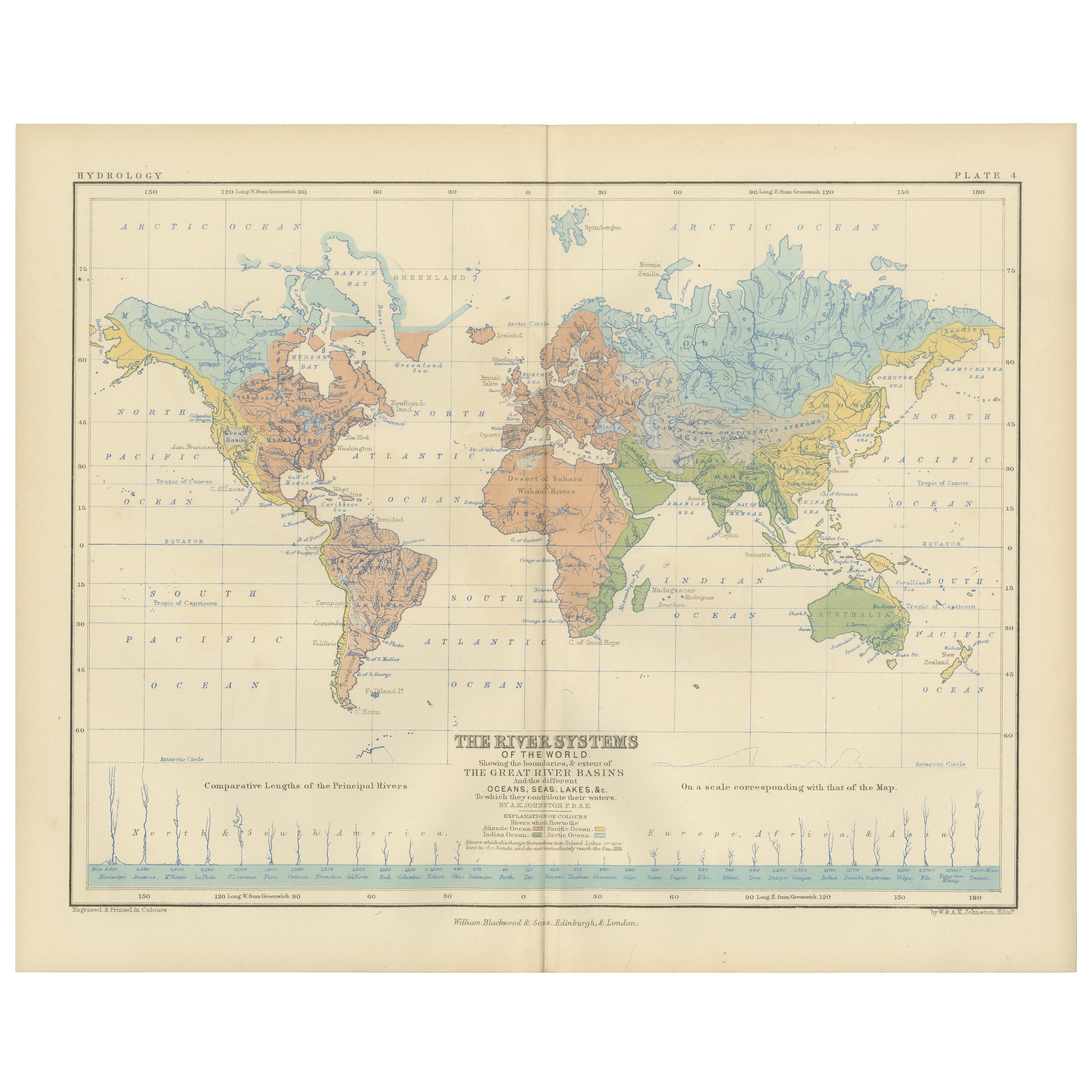
River Systems Map of the World by A.K. Johnston – Educational Print 1852
River Systems Map of the World by A.K. Johnston – Educational Print 1852
This striking 1852 map titled "The River Systems of the World" was created by the noted Scottish geographer ...
Categoría
Antiguo, Mediados del siglo XIX, Escocés, Impresiones
Materiales
Papel

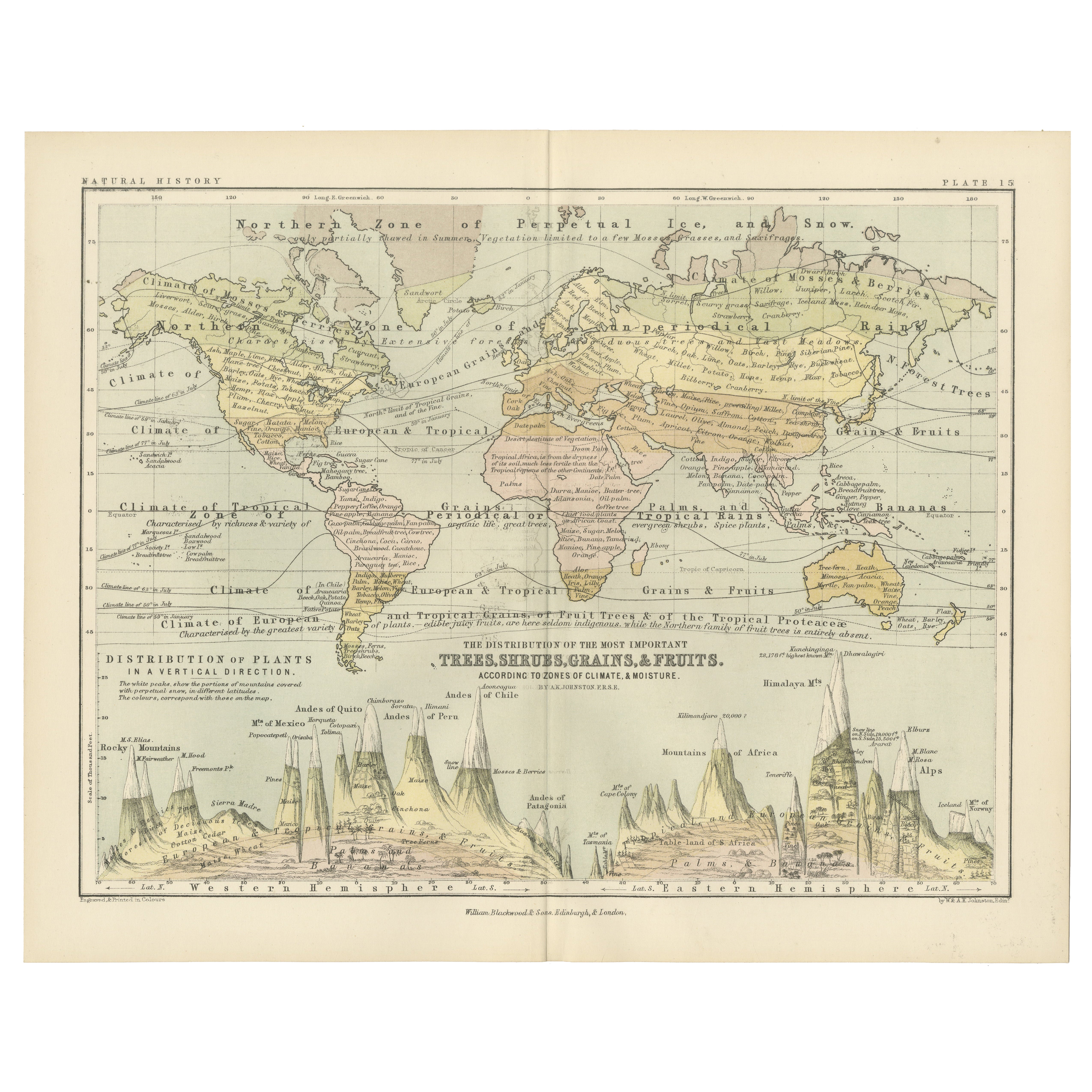
Botanical Map by A.K. Johnston – Global Plant Distribution Chart 1852
Botanical Map by A.K. Johnston – Global Plant Distribution Chart 1852
This remarkable antique chart titled "The Distribution of the Most Important Trees, Shrubs, Grains, & Fruits Ac...
Categoría
Antiguo, Mediados del siglo XIX, Escocés, Impresiones
Materiales
Papel
También te puede gustar
Mapa Antiguo Original del Mundo por Dower, circa 1835
Bonito mapa del Mundo
Dibujado y grabado por J.Dower
Publicado por Orr & Smith. C.1835
Sin enmarcar.
Envío gratuito
Categoría
Antiguo, Década de 1830, Inglés, Mapas
Materiales
Papel

Mapa antiguo del Imperio Británico - Mapa antiguo de Karl Spruner - 1760 ca.
Por Karl Spruner von Merz
Antiguo mapa del Imperio Británico es una obra de arte realizada hacia 1760 por Karl Spruner.
Grabado original coloreado a mano.
Buen estado, salvo por el amarilleamiento del papel...
Categoría
Década de 1760, Moderno, Impresiones figurativas
Materiales
Grabado químico

Gran Mapa Antiguo Original del Mundo, Fullarton, C.1870
Gran mapa del Mundo. Mostrando ambos hemisferios
Del célebre Atlas Real Ilustrado
Litografía. Color original.
Publicado por Fullarton, Edimburgo, C.1870
Sin enmarcar.
Reparació...
Categoría
Antiguo, Década de 1870, Escocés, Mapas
Materiales
Papel

1864 Planisferio ilustrado original - Mapamundi - Geografía
Sumérgete en el viaje épico del pasado con el Planisferio Histórico Ilustrado de 1864 de Charpentier! 🗺️ Este tesoro cartográfico te transporta a través de los entresijos de la hist...
Categoría
Década de 1860, Impresiones y múltiplos
Materiales
Lino, Papel, Litografía

Mapa Antiguo Original del Hemisferio Oriental por Dower, hacia 1835
Bonito mapa del hemisferio oriental
Dibujado y grabado por J.Dower
Publicado por Orr & Smith. C.1835
Sin enmarcar.
Envío gratuito
Categoría
Antiguo, Década de 1830, Inglés, Mapas
Materiales
Papel

Antiguo mapa original del mundo de Thomas Clerk, 1817
Gran mapa de los hemisferios oriental y occidental
En 2 hojas
Grabado en cobre
Dibujado y grabado por Thomas Clerk, Edimburgo.
Publicado por Mackenzie And Dent, 1817
S...
Categoría
Antiguo, Década de 1810, Inglés, Mapas
Materiales
Papel
