Artículos similares a Ancient Egypt – Nile Valley Map by d’Anville, Classical Antiquity, c.1765


¿Quieres más imágenes o vídeos?
Solicita imágenes o vídeos adicionales al vendedor
1 de 9
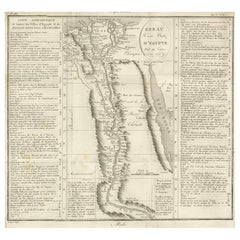
Ancient Egypt – Nile Valley Map by d’Anville, Classical Antiquity, c.1765
570 €IVA incluido
Acerca del artículo
Ancient Egypt – Nile Valley Map by d’Anville, Classical Antiquity, c.1765
This finely engraved map depicts Ancient Egypt as understood through classical sources, extending along the Nile Valley from the Mediterranean Delta southward into Nubia, with adjacent regions of Arabia Petraea and the Red Sea coast. The map is titled “Ægyptus Antiqua” and was compiled by Jean-Baptiste Bourguignon d’Anville, one of the most influential and scholarly cartographers of the 18th century.
D’Anville’s approach marked a decisive shift away from speculative geography. Drawing on ancient Greek and Roman authors such as Herodotus, Strabo, Pliny, and Ptolemy, he sought to reconstruct the geography of antiquity with critical rigor. Cities, nomes, temples, and classical place names are carefully plotted along the Nile, offering a structured and historically grounded vision of Pharaonic Egypt as interpreted through classical antiquity.
The Nile dominates the composition, rendered as the organizing spine of Egyptian civilization. Branches of the Delta, desert regions, and mountain ranges are delicately engraved, while subtle hand color highlights coastlines and regional boundaries without overwhelming the clarity of the map. To the east, the Red Sea and Arabian Peninsula provide geographical context for ancient trade routes and cultural exchange.
Visually, the map balances scholarship and elegance. The restrained engraving style, generous white space, and vertical format give it a calm, architectural presence, making it particularly attractive for interior display. It works equally well as a collector’s piece or as a refined statement map in both classic and contemporary settings.
This map is highly sought after by collectors of Egyptology, classical history, and Enlightenment cartography, and it pairs beautifully with other 18th-century maps of North Africa, the Mediterranean, or the ancient world.
Condition report
Good condition overall. Light age toning. Original outline hand color. Plate mark visible. Margins intact. Right margin tight. Strong paper.
Framing tips
A wide off-white or light sand-colored mat enhances the vertical composition and emphasizes the Nile’s flow through the map. A medium to dark wood frame or softly ebonized frame gives the piece a refined, museum-style appearance, suitable for both residential and hospitality interiors.
Technique: Copper engraving with contemporary outline hand color
Maker: Jean-Baptiste Bourguignon d’Anville, France, c.1765
- Dimensiones:Altura: 55,7 cm (21,93 in)Anchura: 37,5 cm (14,77 in)Profundidad: 0,2 mm (0,01 in)
- Materiales y técnicas:Papel,Grabado
- Lugar de origen:
- Época:
- Fecha de fabricación:circa 1765
- Estado:Good condition overall. Light age toning. Original outline hand color. Plate mark visible. Margins intact. Right margin tight. Strong paper.
- Ubicación del vendedor:Langweer, NL
- Número de referencia:Vendedor: BG-14128-161stDibs: LU3054348017302
Sobre el vendedor
5,0
Vendedor reconocido
Estos prestigiosos vendedores son líderes del sector y representan el escalón más alto en cuanto a calidad y diseño de artículos.
Vendedor Platino
Vendedores premium con una calificación de +4,7 y tiempos de respuesta de 24 horas
Establecido en 2009
Vendedor de 1stDibs desde 2017
2836 ventas en 1stDibs
Tiempo de respuesta usual: 1 hora
- EnvíoRecuperando presupuesto…Envío desde: Langweer, Países Bajos
- Política de devolución
Partes de esta página se han traducido automáticamente. 1stDibs no puede garantizar la exactitud de las traducciones. El inglés es el idioma predeterminado de este sitio web.
Más de este vendedor
Ver todoEgypt
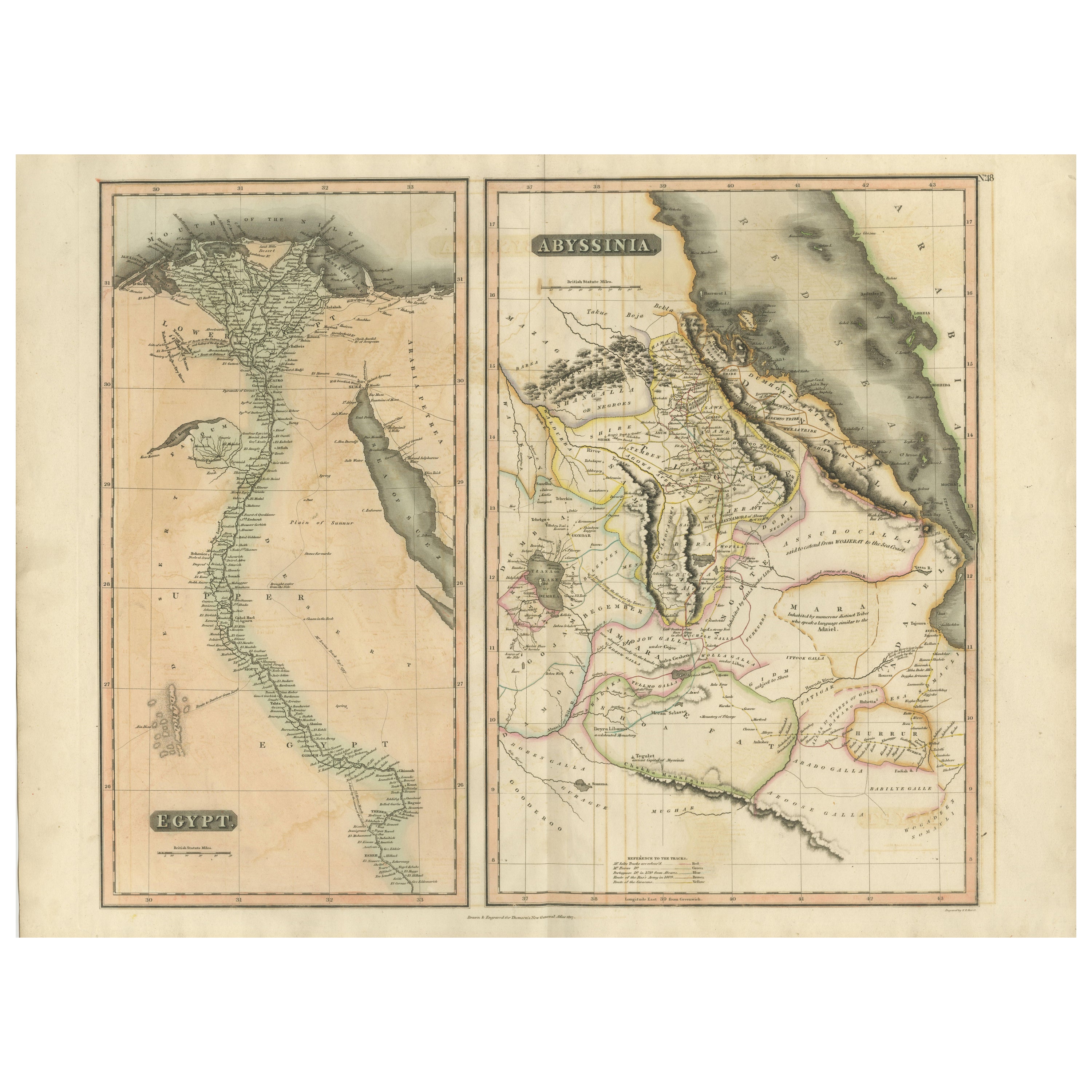
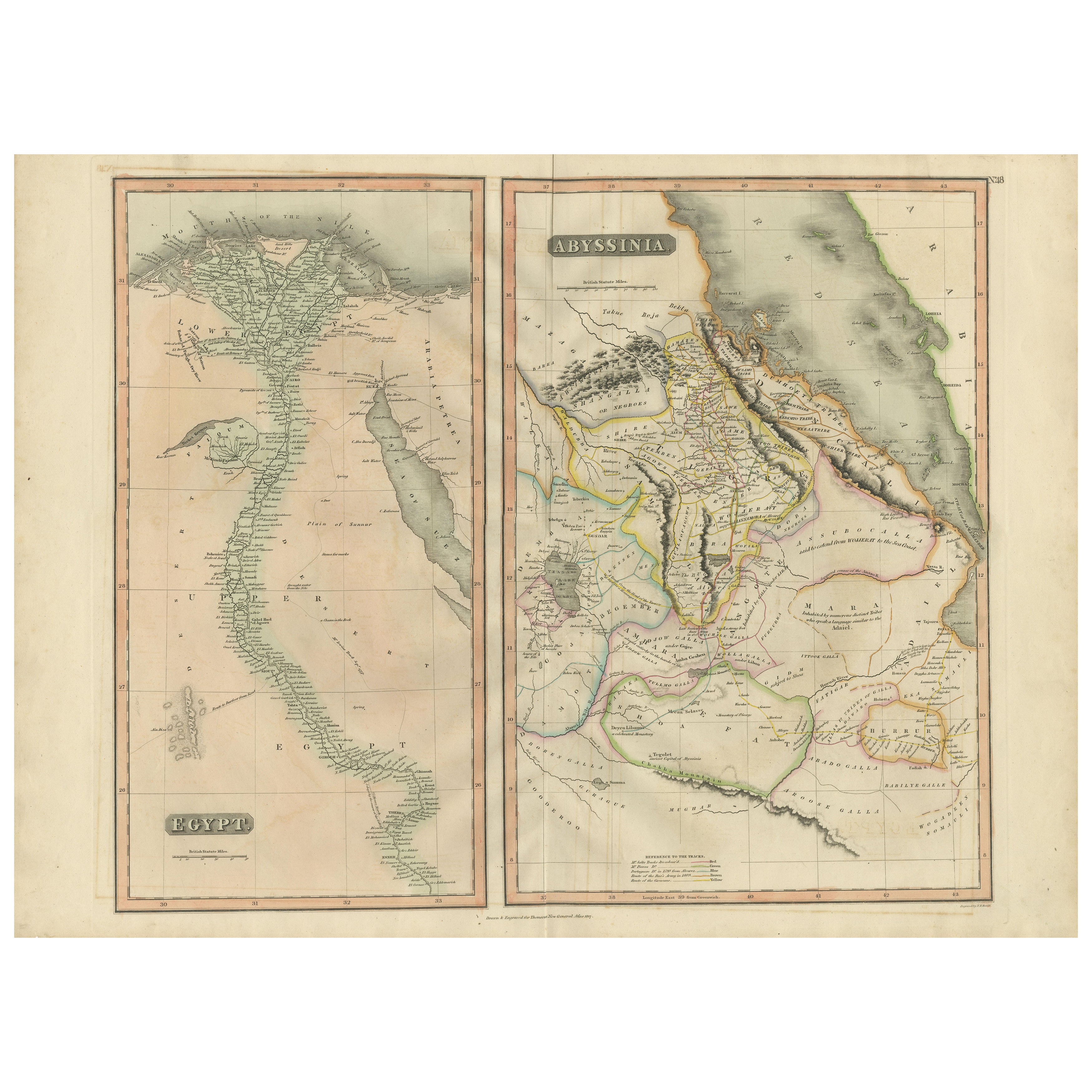
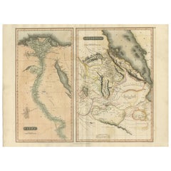
Abyssinia – Original Nile Valley and Horn of Africa Maps, c.1817
Egypt & Abyssinia – Nile Valley and Horn of Africa Maps, c.1817–1820
This refined early 19th-century map composition presents two related geographic views of Northeast Africa: Egypt...
Categoría
Antiguo, Década de 1810, Británico, Mapas
Materiales
Papel
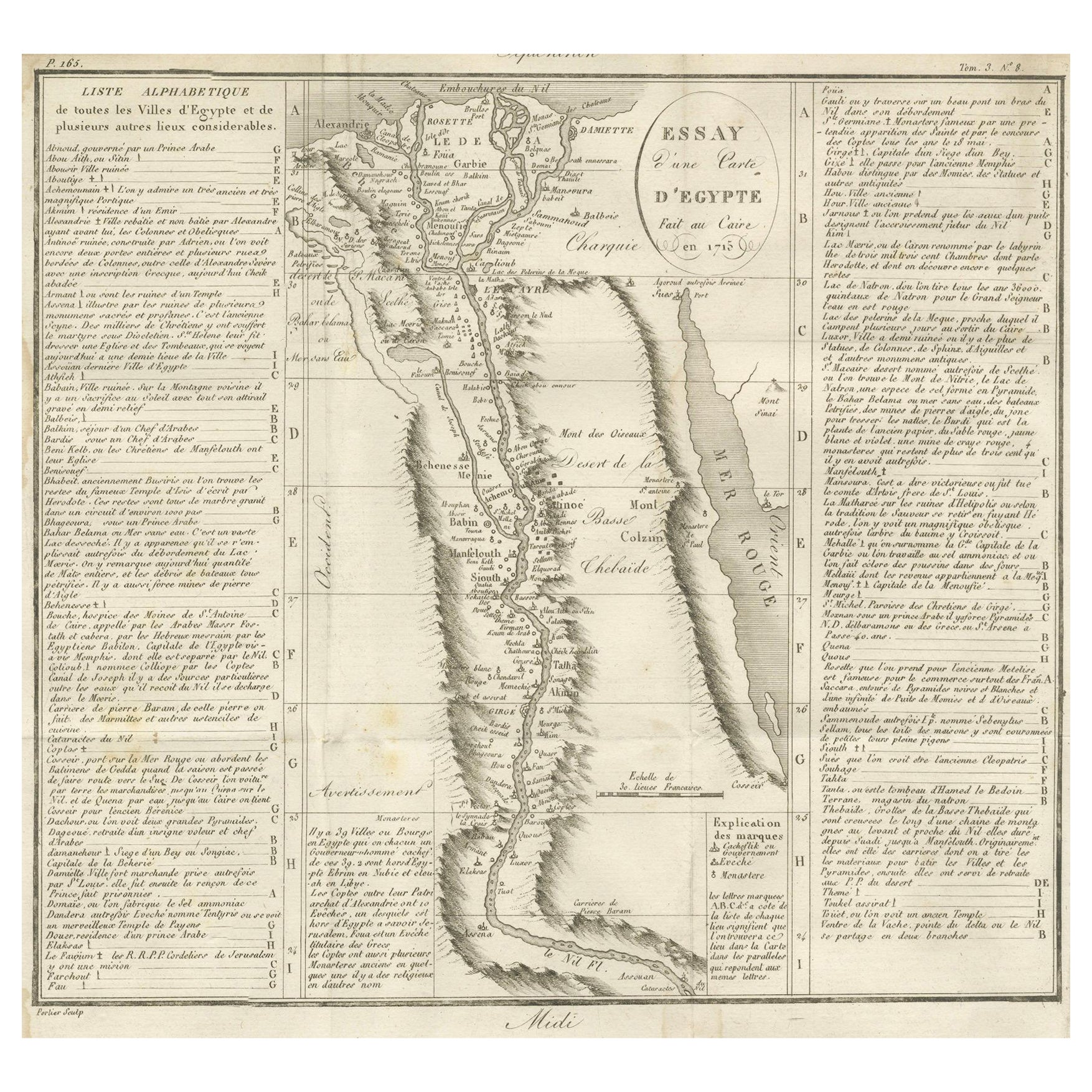
Mapa antiguo de Egipto y el valle del Nilo con índice de ciudades, 1715
Mapa antiguo de Egipto, titulado "Essay d'une Carte d'Égypte Fait au Caire en 1715".
Este mapa finamente grabado presenta una descripción detallada de Egipto a lo largo del río Nil...
Categoría
Antiguo, principios del siglo XVIII, Francés, Mapas
Materiales
Papel
Egypt and Abyssinia – Nile Valley
Horn of Africa Maps, c.1817–1820
Egypt and Abyssinia – Nile Valley & Horn of Africa Maps, c.1817–1820
This refined early 19th-century paired map presents Egypt and Abyssinia (Ethiopia) as two complementary geograph...
Categoría
Antiguo, Década de 1810, Británico, Mapas
Materiales
Papel
Antiguo mapa de Egipto con detalle del delta del Nilo, ca. 1799
Antiguo mapa de Egipto con detalle del delta del Nilo, ca. 1799
Este mapa antiguo finamente grabado titulado Carte Physique et Politique de l'Égypte presenta una visión detallada y ...
Categoría
Antiguo, Principios del 1800, Francés, Mapas
Materiales
Papel

Mapa antiguo del Nilo, Egipto y el Mar Rojo por Bachiene, 1765
Mapa antiguo titulado "De XIde Landkaart verbeeldende Egypte en de Woestyne der Schelf-Zee (..)". Mapa del Egipto bíblico y del Mar Rojo. Con cartela en el título, rosa de los viento...
Categoría
Antiguo, siglo XVIII, Mapas
Materiales
Papel

Mapa antiguo del Antiguo Egipto que representa también el río Nilo y el Mar Rojo, 1845
Mapa antiguo Egipto titulado 'General Karte von Alt Aegypten von A.H. Brué'. Gran mapa de Egipto que representa también el río Nilo y el Mar Rojo. Fuente desconocida, por determinar....
Categoría
Antiguo, siglo XIX, Mapas
Materiales
Papel

También te puede gustar
Mapa de Nubia y Abisinia - Grabado original de Antonio Zatta - 1784
Este Mapa de Nubia y Abisinia es un aguafuerte realizado por Antonio Zatta en Venecia en 1784.
El estado de conservación de la obra es bueno, salvo por el papel desgastado con algun...
Categoría
Década de 1770, Impresiones de paisajes
Materiales
Grabado químico

Mapa Antiguo Original de la Antigua Grecia - Beocia, Tebas, 1787
Gran mapa de la antigua Grecia. Muestra la región de Beocia, incluida Tebas
Dibujado por J.D. Barbie Du Bocage
Grabado en plancha de cobre de P.F Tardieu
Contorno original c...
Categoría
Antiguo, Década de 1780, Francés, Otro, Mapas
Materiales
Papel

Mapa Antiguo Original de la Antigua Grecia, Acaya, Corinto, 1786
Gran mapa de la antigua Grecia. Muestra la región de Tesalia, incluido el monte Olimpo
Dibujado por J.D. Barbie Du Bocage
Grabado en plancha de cobre de P.F Tardieu
Contorno...
Categoría
Antiguo, Década de 1780, Francés, Otro, Mapas
Materiales
Papel

África. Parte Noreste. Atlas del Siglo mapa antiguo de época
El Atlas del Siglo. África. Parte Noreste".
Mapa antiguo original, 1903.
Mapa en recuadro del "Delta del Nilo y Canal de Suez".
Pliegue central como se emitió. Nombre y número del ...
Categoría
principios del siglo XX, Victoriano, Más impresiones
Materiales
Litografía

Mapa de Tierra Santa "Carte de la Syrie et de l
Egypte" de Pierre Lapie
Por Pierre M. Lapie
Se trata de un mapa de la antigua Siria y Egipto de principios del siglo XIX titulado "Carte de la Syrie et de l'Egypte anciennes/dressée par M. Lapie, Colonel d'Etat Major, et M. La...
Categoría
Década de 1830, Impresiones de paisajes
Materiales
Grabado

Mapa original antiguo de África por Dower, hacia 1835
Bonito mapa de África
Dibujado y grabado por J.Dower
Publicado por Orr & Smith. C.1835
Sin enmarcar.
Envío gratuito
Categoría
Antiguo, Década de 1830, Inglés, Mapas
Materiales
Papel
