Artículos similares a Antique French Map of the Holy Land, Twelve Tribes of Israel, c.1750


¿Quieres más imágenes o vídeos?
Solicita imágenes o vídeos adicionales al vendedor
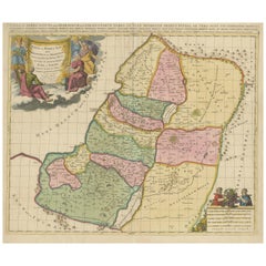
1 de 11
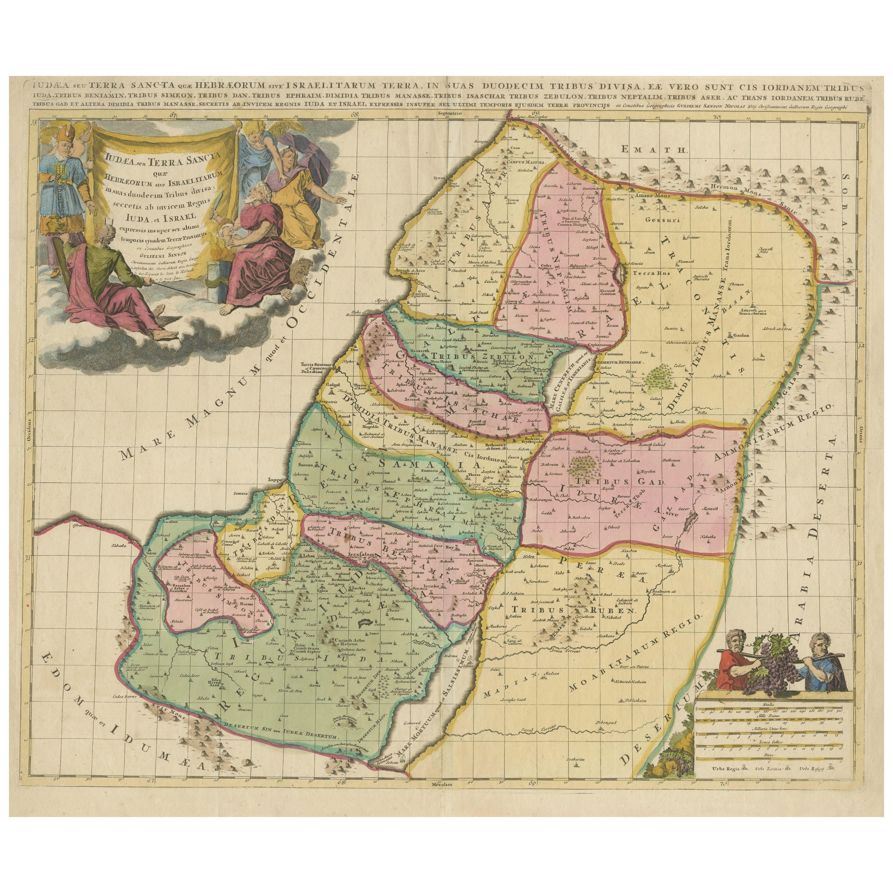
Antique French Map of the Holy Land, Twelve Tribes of Israel, c.1750
1100 €IVA incluido
Acerca del artículo
Antique Holy Land Map, Twelve Tribes of Israel – Robert de Vaugondy, c.1750
Description
This finely engraved and hand-colored map depicts Judea, or the Holy Land, divided according to the Twelve Tribes of Israel, each territory carefully delineated with colored boundaries and identified by name. The composition reflects the scholarly French cartographic tradition of the mid-18th century, combining biblical geography with contemporary geographic knowledge in a visually balanced and highly legible format.
The map was produced in Paris around 1750 by Robert de Vaugondy, one of the most respected mapmakers of the Enlightenment period. Vaugondy’s work is known for its precision, clarity, and elegant ornamentation, qualities that made his maps popular with scholars, collectors, and institutions throughout Europe.
An inset map in the upper left shows Canaan, or the Promised Land, extending into Phoenicia and Syria, with the northeastern reaches of Egypt also indicated. Geographic features such as coastlines, rivers, mountain ranges, deserts, and settlements are carefully rendered, while the Mediterranean Sea and surrounding regions are clearly labeled. The decorative cartouche adds refinement without overwhelming the map’s academic character, making it equally suitable for a study, library, or refined interior.
Maps of the Holy Land from this period remain highly sought after for their historical, religious, and decorative significance. This example offers a particularly appealing balance of scholarship and visual presence, with strong original hand coloring enhancing both the tribal divisions and the overall composition.
Condition report
Good antique condition. Original central fold as issued. Light age toning and minor handling marks consistent with 18th-century paper. No losses or major defects. Overall well-preserved with strong clarity of engraving and color.
Framing tips
This map presents beautifully with a muted walnut or dark ebonized frame paired with an off-white or parchment mat. For a more traditional look, an antique gold frame with a narrow profile will subtly echo the cartouche while maintaining a refined, scholarly appearance.
Technique: Engraving with original hand color
Maker: Robert de Vaugondy, Paris, circa 1750
- Dimensiones:Altura: 51 cm (20,08 in)Anchura: 68 cm (26,78 in)Profundidad: 0,2 mm (0,01 in)
- Materiales y técnicas:Papel,Grabado
- Lugar de origen:
- Época:
- Fecha de fabricación:circa 1750
- Estado:Good antique condition. Original central fold as issued. Light age toning and minor handling marks consistent with 18th-century paper. No losses or major defects. Overall well-preserved with strong clarity of engraving and color.
- Ubicación del vendedor:Langweer, NL
- Número de referencia:Vendedor: BG-14152-21stDibs: LU3054348066812
Sobre el vendedor
5,0
Vendedor reconocido
Estos prestigiosos vendedores son líderes del sector y representan el escalón más alto en cuanto a calidad y diseño de artículos.
Vendedor Platino
Vendedores premium con una calificación de +4,7 y tiempos de respuesta de 24 horas
Establecido en 2009
Vendedor de 1stDibs desde 2017
2813 ventas en 1stDibs
Tiempo de respuesta usual: 1 hora
- EnvíoRecuperando presupuesto…Envío desde: Langweer, Países Bajos
- Política de devolución
Partes de esta página se han traducido automáticamente. 1stDibs no puede garantizar la exactitud de las traducciones. El inglés es el idioma predeterminado de este sitio web.
Más de este vendedor
Ver todoHoly Land Map of the Twelve Tribes of Israel, After Sanson, Paris c.1798
Holy Land, Twelve Tribes of Israel – After Nicolas Sanson, De Vaugondy / Delamarche, c.1798
Description:
Holy Land. De Vaugondy (G. R.), Carte de la Terre des Hébreux ou Israélites,...
Categoría
Antiguo, finales del siglo XVIII, Francés, Mapas
Materiales
Papel

Antique Holy Land Map, Twelve Tribes of Israel – Covens
Mortier, c.1700
Antique Holy Land Map, Twelve Tribes of Israel – Covens
Mortier, c.1700
Description:
This finely engraved early 18th-century map depicts the Holy Land divided according to the...
Categoría
Antiguo, principios del siglo XVIII, Francés, Mapas
Materiales
Papel

Mapa antiguo muy detallado de Tierra Santa con las 12 tribus de Israel, c.1720
Mapa antiguo titulado 'Heylige Land verdeeld in de Twaalf Stammen Israels (..).'
Mapa muy detallado de la Tierra Santa dividida en 12 tribus de Israel. Con una hermosa cartela gr...
Categoría
Antiguo, Década de 1720, Mapas
Materiales
Papel

384 € Precio de venta
Descuento del 20 %
Envío gratuito
Mapa antiguo de Tierra Santa por Van Luchtenburg, c.1720
Mapa antiguo titulado 'Heylige Land verdeeld in de Twaalf Stammen Israels (..).' Mapa muy detallado de Tierra Santa dividida en 12 tribus de Israel. Con una hermosa cartela grande co...
Categoría
Antiguo, siglo XVIII, Mapas
Materiales
Papel

Mapa de Tierra Santa de 1718 - Doce tribus, seis provincias, coloreado a mano, mapa antiguo
Título: Terra Sancta in XII olim Tribus nunc VI Provincias Dispertita
Cartógrafo: Christoph Weigel el Viejo (1654-1725)
Editor: Johann Ernst Adelbulner
Lugar y año de publicaci...
Categoría
Antiguo, Década de 1710, Alemán, Mapas
Materiales
Papel

Judaea or Terra Sancta, Twelve Tribes of Israel – Sanson Map, c.1680
Judaea or Terra Sancta, Twelve Tribes of Israel – Sanson Map, c.1680
This antique map depicts Judaea or the Holy Land divided among the Twelve Tribes of Israel, based on biblical ge...
Categoría
Antiguo, finales del siglo XVII, Holandés, Mapas
Materiales
Papel
También te puede gustar
Mapa Tierra Santa La Terre Sainte Grabado van Loon Publicado N de Fer 1703 Francés
La Terre Sainte, La Tierra Santa, Tiree Des Memoires De M.De.La Rue. Par N. de Fer. Geographe de Sa Majeste Catoliq et de Monseigneur le Dauphin. Avec Privil du Roi 1703
Mapa deta...
Categoría
Antiguo, Principios del 1700, Francés, Luis XIV, Mapas
Materiales
Papel

Li Governi di Borgogna - Mapa antiguo - 1777
Li Governi di Borgogna es un aguafuerte original en blanco y negro sobre papel, impreso por Antonio Zatta en Venecia, 1777.
Título original: Li Governi di Borgogna della Franca Cont...
Categoría
Década de 1770, Moderno, Impresiones de paisajes
Materiales
Grabado químico

La región francesa de Normandía: Mapa coloreado a mano del siglo XVII por Sanson y Jaillot
Por Nicolas Sanson
Este gran mapa coloreado a mano titulado "Le Duché et Gouvernement de Normandie divisée en Haute et Basse Normandie en divers Pays; et par evêchez, avec le Gouvernement General du Ha...
Categoría
Antiguo, Década de 1690, Francés, Mapas
Materiales
Papel

1646 € Precio de venta
Descuento del 20 %
Grecia Meridional: Un gran mapa coloreado a mano del siglo XVII por Sanson y Jaillot
Por Nicholas Sanson d
Abbeville
Este gran mapa original grabado a mano en cobre del sur de Grecia y la península del Peloponeso, titulado "La Moree Et Les Isles De Zante, Cefalonie, Ste. Marie, Cerigo & C. Dresse S...
Categoría
Década de 1690, Impresiones de paisajes
Materiales
Grabado

1368 € Precio de venta
Descuento del 20 %
1657 Mapa Janssonius de Vermandois y Cappelle, Ric. A-004
1657 Mapa de Janssonius de
Vermandois y Cappelle
Ric.a004
Descripción: Mapa antiguo de Francia titulado "Descriptio Veromanduorum - Gouvernement de la Cappelle". Dos mapas det...
Categoría
Antiguo, siglo XVII, Desconocido, Mapas
Materiales
Papel

Portugal: Un gran mapa coloreado a mano del siglo XVII por Sanson y Jaillot
Por Nicholas Sanson d
Abbeville
Este gran mapa coloreado a mano titulado "Le Royaume de Portugal et des Algarves Divisee en see Archeveches, Eveches et Territoires Par le Sr Sanson" fue creado originalmente por Nic...
Categoría
Década de 1690, Impresiones de paisajes
Materiales
Grabado

1507 € Precio de venta
Descuento del 20 %