Artículos similares a Antique Holy Land Map, Twelve Tribes of Israel – Covens
Mortier, c.1700


¿Quieres más imágenes o vídeos?
Solicita imágenes o vídeos adicionales al vendedor
1 de 10
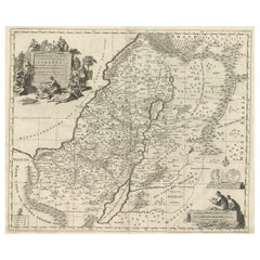
Antique Holy Land Map, Twelve Tribes of Israel – Covens
Mortier, c.1700
1200 €IVA incluido
Acerca del artículo
Antique Holy Land Map, Twelve Tribes of Israel – Covens
Mortier, c.1700
Description:
This finely engraved early 18th-century map depicts the Holy Land divided according to the Twelve Tribes of Israel. Titled Het Heylige Land verdeeld in de Twaalf Stammen Israëls, it presents biblical Palestine as understood through scripture and classical sources, rather than as a contemporary political geography. The map was published in Amsterdam around 1700 by the renowned firm Covens
Mortier and engraved by Johannes van Luchtenburgh.
The territories of the Twelve Tribes are clearly defined and densely labeled, covering Judaea, Samaria, Galilee, and Transjordan. Major biblical landmarks such as the Jordan River, the Dead Sea, and the Sea of Galilee structure the composition, while surrounding regions including Arabia, Phoenicia, and parts of Egypt provide geographical context. Mountains, rivers, settlements, and place names associated with Old Testament history are carefully engraved throughout, making the map both informative and visually rich.
Decorative engraving enhances the map’s devotional and scholarly character. An elaborate allegorical cartouche at upper left shows biblical figures gathered around the Tablets of the Law, emphasizing the sacred foundation of the subject. At lower right, a seated scholar engaged in study reinforces the map’s role as a tool for biblical learning and interpretation. These elements reflect the strong Protestant interest in biblical geography in Northern Europe around 1700, when such maps were widely used for teaching, study, and display.
Produced to a high standard typical of Dutch mapmaking at the turn of the 18th century, this map balances detailed scholarship with restrained ornament. It was intended not for navigation, but for theological reference and visualizing scripture, and today it remains highly desirable among collectors of Holy Land maps, biblical cartography, and early Dutch engravings.
Condition report:
Good overall condition with a strong, clear impression. Light age toning and minor surface wear consistent with age. Margins present.
Framing tips:
This map frames beautifully in a classic black or dark walnut frame with an ivory or parchment-colored mat to emphasize the fine engraving. A slightly wider mat allows the decorative cartouches to breathe and enhances the map’s presence as a wall piece.
Technique: engraving
Maker: Johannes van Luchtenburgh, Netherlands (published by Covens
Mortier, Amsterdam, c.1700)
- Dimensiones:Altura: 40 cm (15,75 in)Anchura: 47 cm (18,51 in)Profundidad: 0,2 mm (0,01 in)
- Materiales y técnicas:Papel,Grabado
- Lugar de origen:
- Época:
- Fecha de fabricación:circa 1700
- Estado:Good overall condition with a strong, clear impression. Light age toning and minor surface wear consistent with age. Margins present.
- Ubicación del vendedor:Langweer, NL
- Número de referencia:Vendedor: BG-14152-11stDibs: LU3054348068952
Sobre el vendedor
5,0
Vendedor reconocido
Estos prestigiosos vendedores son líderes del sector y representan el escalón más alto en cuanto a calidad y diseño de artículos.
Vendedor Platino
Vendedores premium con una calificación de +4,7 y tiempos de respuesta de 24 horas
Establecido en 2009
Vendedor de 1stDibs desde 2017
2813 ventas en 1stDibs
Tiempo de respuesta usual: 1 hora
- EnvíoRecuperando presupuesto…Envío desde: Langweer, Países Bajos
- Política de devolución
Partes de esta página se han traducido automáticamente. 1stDibs no puede garantizar la exactitud de las traducciones. El inglés es el idioma predeterminado de este sitio web.
Más de este vendedor
Ver todoAntique French Map of the Holy Land, Twelve Tribes of Israel, c.1750
Antique Holy Land Map, Twelve Tribes of Israel – Robert de Vaugondy, c.1750
Description
This finely engraved and hand-colored map depicts Judea, or the Holy Land, divided according ...
Categoría
Antiguo, mediados del siglo XVIII, Francés, Mapas
Materiales
Papel
Mapa antiguo muy detallado de Tierra Santa con las 12 tribus de Israel, c.1720
Mapa antiguo titulado 'Heylige Land verdeeld in de Twaalf Stammen Israels (..).'
Mapa muy detallado de la Tierra Santa dividida en 12 tribus de Israel. Con una hermosa cartela gr...
Categoría
Antiguo, Década de 1720, Mapas
Materiales
Papel

384 € Precio de venta
Descuento del 20 %
Envío gratuito
Holy Land Map of the Twelve Tribes of Israel, After Sanson, Paris c.1798
Holy Land, Twelve Tribes of Israel – After Nicolas Sanson, De Vaugondy / Delamarche, c.1798
Description:
Holy Land. De Vaugondy (G. R.), Carte de la Terre des Hébreux ou Israélites,...
Categoría
Antiguo, finales del siglo XVIII, Francés, Mapas
Materiales
Papel

Mapa de Tierra Santa dividida en 12 tribus, los viajes de Jesucristo, 1700
Mapa antiguo titulado "Het Heylige Land verdeeld in de Twaalf Stammen Israels (..)".
Mapa decorativo y detallado de Tierra Santa dividida en 12 Tribus, que muestra los viajes de ...
Categoría
Antiguo, Principios del 1700, Mapas
Materiales
Papel
392 € Precio de venta
Descuento del 20 %
Judaea or Terra Sancta, Twelve Tribes of Israel – Sanson Map, c.1680
Judaea or Terra Sancta, Twelve Tribes of Israel – Sanson Map, c.1680
This antique map depicts Judaea or the Holy Land divided among the Twelve Tribes of Israel, based on biblical ge...
Categoría
Antiguo, finales del siglo XVII, Holandés, Mapas
Materiales
Papel
Mapa antiguo de Tierra Santa por Van Luchtenburg, c.1720
Mapa antiguo titulado 'Heylige Land verdeeld in de Twaalf Stammen Israels (..).' Mapa muy detallado de Tierra Santa dividida en 12 tribus de Israel. Con una hermosa cartela grande co...
Categoría
Antiguo, siglo XVIII, Mapas
Materiales
Papel

También te puede gustar
Mapa Tierra Santa La Terre Sainte Grabado van Loon Publicado N de Fer 1703 Francés
La Terre Sainte, La Tierra Santa, Tiree Des Memoires De M.De.La Rue. Par N. de Fer. Geographe de Sa Majeste Catoliq et de Monseigneur le Dauphin. Avec Privil du Roi 1703
Mapa deta...
Categoría
Antiguo, Principios del 1700, Francés, Luis XIV, Mapas
Materiales
Papel

1657 Mapa Janssonius de Vermandois y Cappelle, Ric. A-004
1657 Mapa de Janssonius de
Vermandois y Cappelle
Ric.a004
Descripción: Mapa antiguo de Francia titulado "Descriptio Veromanduorum - Gouvernement de la Cappelle". Dos mapas det...
Categoría
Antiguo, siglo XVII, Desconocido, Mapas
Materiales
Papel

Mapa holandés del siglo XVII de Tierra Santa en tiempos de Jesús, por Visscher
Por Nicolaus Visscher
Este detallado mapa holandés titulado "Het Beloofe de Landt Canaan door wandelt van onsen Salichmaecker Iesu Christo, nessens syne Apostelen" de Nicolaes Visscher (1610-1679), public...
Categoría
Década de 1660, Impresiones y múltiplos
Materiales
Grabado

882 € Precio de venta
Descuento del 20 %
"Nova Barbariae Descriptio", un mapa coloreado a mano del norte de África del siglo XVII
Por Johannes Janssonius
Este atractivo mapa original del siglo XVII del norte de África, coloreado a mano y titulado "Nova Barbariae Descriptio" de Johannes Janssonius, se publicó en París en 1635. Incluye ...
Categoría
Antiguo, mediados del siglo XVII, Holandés, Mapas
Materiales
Papel

882 € Precio de venta
Descuento del 20 %
1714 Henri Chatelain "Nouvelle Carte Des Etatas Du Grand.Duc De Moscovie Eur
Un mapa de Henri Chatelain de 1714, titulado
"Nueva Carta de los Estados del Gran Duque de Moscú en Europa".
Ricb001
Henri-Abraham Chatelain (1684-1743) fue un pastor hugonote ...
Categoría
Antiguo, principios del siglo XVIII, Holandés, Mapas
Materiales
Papel

1640 Joan Bleau Mapa titulado "Diocecese de rheims et le pais de rethel, " Eic.a011
1640 Mapa de Joan Bleau titulado
"Diocecese de rheims et le pais de rethel".
Ric.a011
OAN BLAEU
Diocecese de Reims, et le pais de Rethel.
Grabado coloreado a mano, c.1...
Categoría
Antiguo, siglo XVII, Holandés, Mapas
Materiales
Papel
