Artículos similares a Egypt
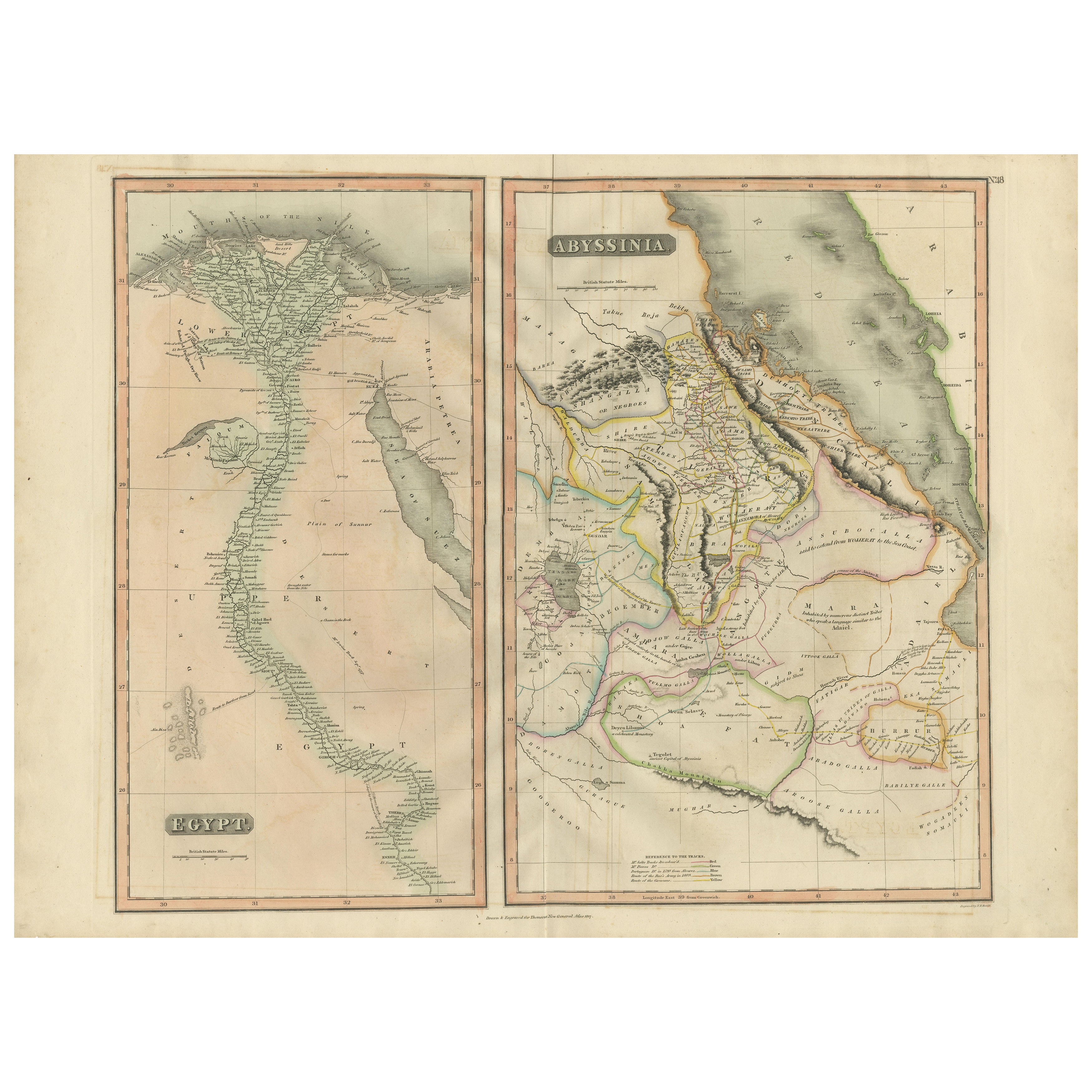
Abyssinia – Original Nile Valley and Horn of Africa Maps, c.1817


¿Quieres más imágenes o vídeos?
Solicita imágenes o vídeos adicionales al vendedor
1 de 9
Egypt
Abyssinia – Original Nile Valley and Horn of Africa Maps, c.1817
550 €IVA incluido
Acerca del artículo
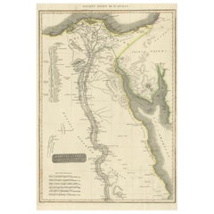
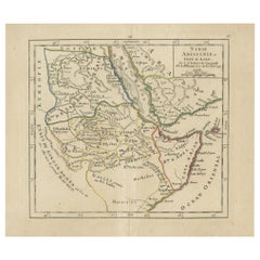
Egypt
Abyssinia – Nile Valley and Horn of Africa Maps, c.1817–1820
This refined early 19th-century map composition presents two related geographic views of Northeast Africa: Egypt with the full course of the Nile River, and Abyssinia (Ethiopia) with the Horn of Africa and Red Sea coast. Issued as companion maps circa 1817–1820, the sheets offer a clear and elegant overview of one of the most historically and geographically significant regions of Africa.
The Egypt map focuses on the Nile Valley from the Mediterranean Delta southward into Upper Egypt, emphasizing the river’s role as the organizing axis of settlement, agriculture, and civilization. Cities, river branches, desert regions, and historic sites are carefully engraved, creating a calm vertical composition that highlights the Nile’s uninterrupted flow through the landscape.
The Abyssinia map complements this view by presenting Ethiopia and the Horn of Africa, including the Red Sea coastline, inland mountain ranges, river systems, and regional boundaries. Political divisions are delicately outlined in contemporary hand color, distinguishing provinces and neighboring territories while maintaining visual clarity. Together, the two maps provide a balanced perspective on the Nile’s sources, surrounding highlands, and the broader Northeast African context.
The engraving style is clean and legible, characteristic of early 19th-century British atlas cartography, combining scientific precision with restrained elegance. Subtle hand coloring enhances coastlines and borders without overpowering the geography. When viewed together, the tall vertical Egypt map and the more compact Abyssinia map create a visually pleasing contrast that works exceptionally well for interior display.
This paired presentation appeals to collectors of African cartography, Nile history, and Ethiopian history, while also offering strong decorative value for both classic and contemporary interiors. Displayed side by side, the maps form a coherent and visually harmonious statement piece.
Condition report
Good condition overall. Central vertical folds as issued. Light age toning and some mild discoloration, more noticeable on the Egypt sheet. Minor scattered spots and light handling marks. Original outline hand color. Plate marks visible. Margins intact.
Framing tips
These maps work beautifully framed as a pair. Use matching off-white or light sand-colored mats to unify the presentation while allowing each map to breathe. Medium to dark wood frames or softly ebonized frames enhance the engraved detail and create a refined, gallery-ready appearance suitable for residential or hospitality interiors.
Technique: Copper engraving with contemporary outline hand color
Maker: British school (Thomson), c.1817
- Dimensiones:Altura: 54 cm (21,26 in)Anchura: 71,5 cm (28,15 in)Profundidad: 0,2 mm (0,01 in)
- Materiales y técnicas:Papel,Grabado
- Lugar de origen:
- Época:
- Fecha de fabricación:circa 1817
- Estado:Good condition overall. Vertical fold as issued. Light age toning and some mild discoloration, more noticeable on the Egypt sheet. Minor scattered spots and light handling marks. Original outline hand color. Plate marks visible. Margins intact.
- Ubicación del vendedor:Langweer, NL
- Número de referencia:Vendedor: BG-14128-121stDibs: LU3054348017432
Sobre el vendedor
5,0
Vendedor reconocido
Estos prestigiosos vendedores son líderes del sector y representan el escalón más alto en cuanto a calidad y diseño de artículos.
Vendedor Platino
Vendedores premium con una calificación de +4,7 y tiempos de respuesta de 24 horas
Establecido en 2009
Vendedor de 1stDibs desde 2017
2836 ventas en 1stDibs
Tiempo de respuesta usual: 1 hora
- EnvíoRecuperando presupuesto…Envío desde: Langweer, Países Bajos
- Política de devolución
Partes de esta página se han traducido automáticamente. 1stDibs no puede garantizar la exactitud de las traducciones. El inglés es el idioma predeterminado de este sitio web.
Más de este vendedor
Ver todoEgypt and Abyssinia – Nile Valley
Horn of Africa Maps, c.1817–1820
Egypt and Abyssinia – Nile Valley & Horn of Africa Maps, c.1817–1820
This refined early 19th-century paired map presents Egypt and Abyssinia (Ethiopia) as two complementary geograph...
Categoría
Antiguo, Década de 1810, Británico, Mapas
Materiales
Papel
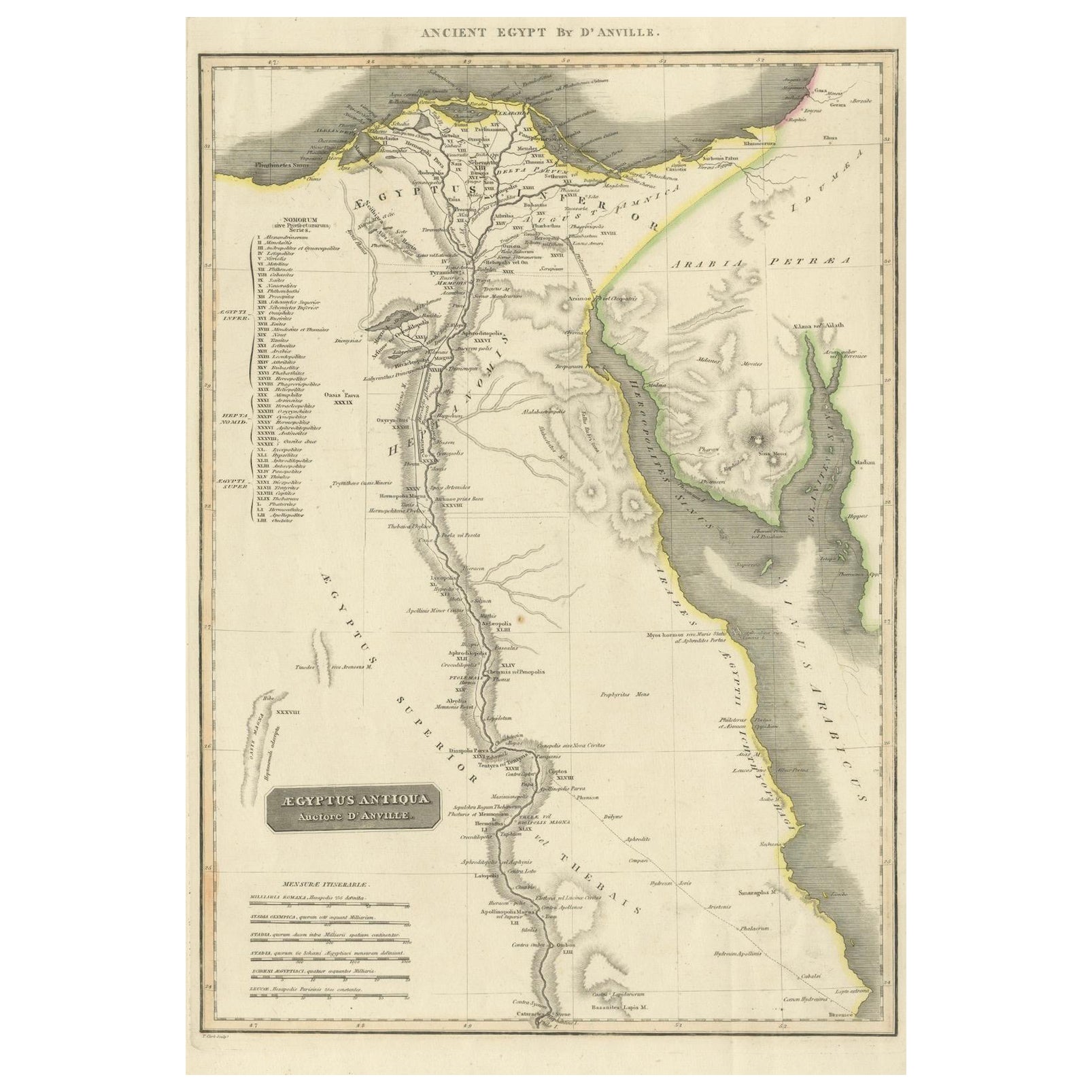
Ancient Egypt – Nile Valley Map by d’Anville, Classical Antiquity, c.1765
Ancient Egypt – Nile Valley Map by d’Anville, Classical Antiquity, c.1765
This finely engraved map depicts Ancient Egypt as understood through classical sources, extending along the...
Categoría
Antiguo, Década de 1760, Francés, Mapas
Materiales
Papel
Antiguo mapa de Egipto con detalle del delta del Nilo, ca. 1799
Antiguo mapa de Egipto con detalle del delta del Nilo, ca. 1799
Este mapa antiguo finamente grabado titulado Carte Physique et Politique de l'Égypte presenta una visión detallada y ...
Categoría
Antiguo, Principios del 1800, Francés, Mapas
Materiales
Papel

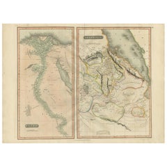
Egypt
Arabia Petraea – Large Nile Map, British Cartography, c.1815
Egypt & Arabia Petraea – Large Nile Map, British Cartography, c.1815
This impressive early 19th-century map depicts Egypt and Arabia Petraea with exceptional detail, extending from ...
Categoría
Antiguo, Década de 1810, Británico, Mapas
Materiales
Papel

Gran Mapa Antiguo del Valle del Bajo Nilo, incluyendo Egipto y Nubia, 1842
Mapa antiguo titulado "Carte de l'Égypte, de la Nubie, de l'Abissinie". Mapa de Egipto, que abarca el valle inferior del Nilo, incluyendo Egipto y Nubia. Este mapa procede del "Atlas...
Categoría
Antiguo, siglo XIX, Francés, Mapas
Materiales
Papel

360 € Precio de venta
Descuento del 20 %
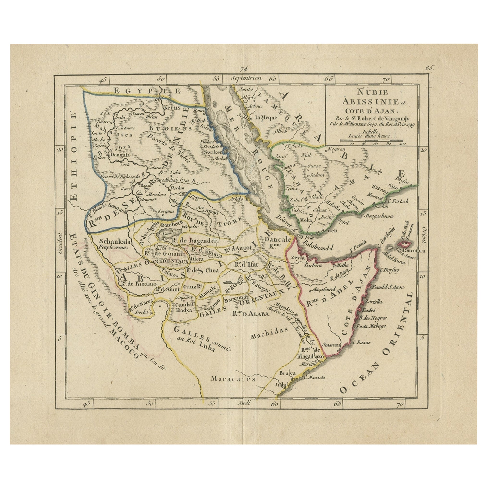
Mapa antiguo de Abisinia, Sudán y el Mar Rojo, Arabia y Egipto Sur, 1749
Mapa antiguo titulado "Nubie, Abissinie et Cote d'Ajan". Mapa de Abisinia, Sudán y el Mar Rojo por Robert The Vaugondy. Abarca desde Arabia y Egipto hacia el sur hasta Mogadiscio e i...
Categoría
Antiguo, siglo XVIII, Mapas
Materiales
Papel
También te puede gustar
África. Parte Noreste. Atlas del Siglo mapa antiguo de época
El Atlas del Siglo. África. Parte Noreste".
Mapa antiguo original, 1903.
Mapa en recuadro del "Delta del Nilo y Canal de Suez".
Pliegue central como se emitió. Nombre y número del ...
Categoría
principios del siglo XX, Victoriano, Más impresiones
Materiales
Litografía

Mapa original antiguo de África por Dower, hacia 1835
Bonito mapa de África
Dibujado y grabado por J.Dower
Publicado por Orr & Smith. C.1835
Sin enmarcar.
Envío gratuito
Categoría
Antiguo, Década de 1830, Inglés, Mapas
Materiales
Papel

África. Parte Noroeste. Atlas del Siglo mapa antiguo de época
El Atlas del Siglo. África. Parte Sur".
Mapa antiguo original, 1903.
Pliegue central como se emitió. Nombre y número del mapa impresos en las esquinas del reverso.
Hoja de 40 cm po...
Categoría
principios del siglo XX, Victoriano, Más impresiones
Materiales
Litografía

Mapa de Nubia y Abisinia - Grabado original de Antonio Zatta - 1784
Este Mapa de Nubia y Abisinia es un aguafuerte realizado por Antonio Zatta en Venecia en 1784.
El estado de conservación de la obra es bueno, salvo por el papel desgastado con algun...
Categoría
Década de 1770, Impresiones de paisajes
Materiales
Grabado químico

Antiguo Mapa Italiano de Asia de 1803 que Incluye China Indoneseia India
Antiguo Mapa Italiano de Asia de 1803 que Incluye China Indoneseia India
Muy bonito mapa de Asia. 1803.
Más información:
Tipo: Mapa
País de fabricación: Europa
Periodo: Siglo XIX Q...
Categoría
Antiguo, siglo XIX, Europeo, Mapas
Materiales
Papel

384 € Precio de venta
Descuento del 39 %
Mapa de Tierra Santa "Carte de la Syrie et de l
Egypte" de Pierre M. Lapie
Por Pierre M. Lapie
Mapa de la antigua Siria y Egipto de principios del siglo XIX titulado "Carte de la Syrie et de l'Egypte anciennes/dressée par M. Lapie, Colonel d'Etat Major, et M. Lapie fils, Capta...
Categoría
Antiguo, principios del siglo XIX, Francés, Mapas
Materiales
Papel
