Artículos similares a Egypt
Arabia Petraea – Large Nile Map, British Cartography, c.1815


¿Quieres más imágenes o vídeos?
Solicita imágenes o vídeos adicionales al vendedor
1 de 10
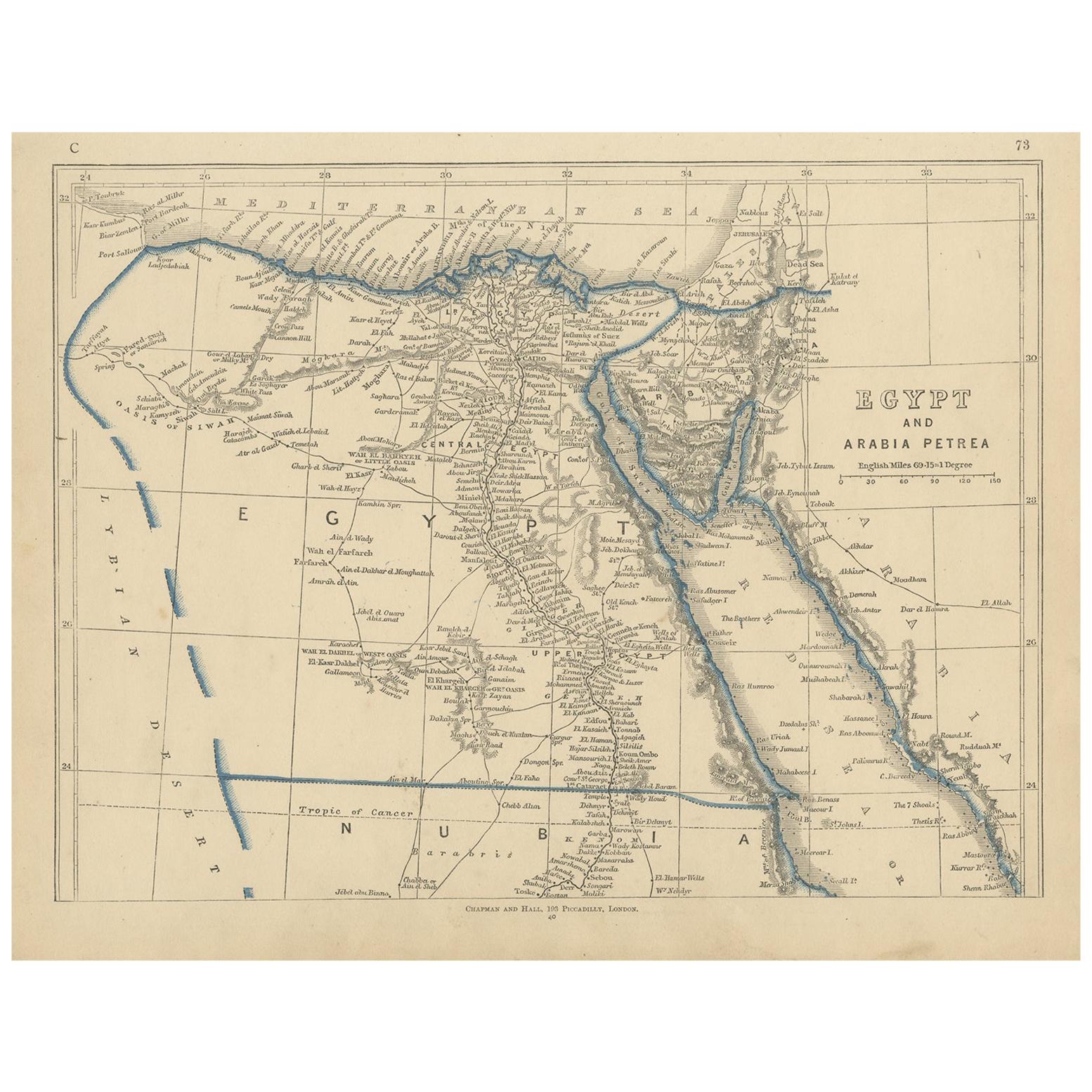
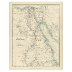
Egypt
Arabia Petraea – Large Nile Map, British Cartography, c.1815
840 €IVA incluido
Acerca del artículo
Egypt
Arabia Petraea – Large Nile Map, British Cartography, c.1815
This impressive early 19th-century map depicts Egypt and Arabia Petraea with exceptional detail, extending from the Mediterranean Sea and the Nile Delta southward through Upper Egypt and Nubia, and eastward across the Red Sea to the Arabian Peninsula. Titled “Egypt and Arabia Petraea,” the map reflects the heightened European scholarly and strategic interest in Egypt during the years surrounding the Napoleonic campaigns and the subsequent rise of modern scientific cartography.
The Nile dominates the composition as the central geographic and cultural axis of Egypt. Its full course is meticulously traced, with branches, cataracts, settlements, ancient sites, desert routes, and regional divisions carefully engraved. The surrounding deserts, mountain ranges, and caravan paths are rendered with restraint, emphasizing the river’s singular role in sustaining civilization. To the east, Arabia Petraea and the Red Sea coastline provide essential context for ancient and early modern trade routes linking Africa, the Levant, and the Indian Ocean world.
The map belongs to the British cartographic tradition associated with the Arrowsmith circle and related London publishers, known for their emphasis on empirical accuracy, clarity, and large-scale presentation. The engraving is precise and refined, with dense but highly legible geographical information. Subtle outline color is used sparingly to distinguish coastlines and regional boundaries without disturbing the map’s calm, scholarly aesthetic.
Visually, this is a powerful wall map. Its tall vertical format, generous margins, and restrained monochrome palette give it an architectural presence that works exceptionally well in both classic and contemporary interiors. It functions equally as a collector-grade document of early modern Egypt and as a sophisticated decorative centerpiece.
This map is particularly appealing to collectors of Egyptology, Nile history, and 19th-century British cartography, as well as interior designers seeking a large, authoritative historic map with strong visual impact.
Condition report
Good condition overall. Central vertical fold as issued. Light age toning consistent with period. Minor scattered spots and faint surface marks. Original outline hand color. Plate mark visible. Margins intact.
Framing tips
This map benefits from a wide off-white or light sand-colored mat to emphasize its scale and vertical flow. A medium to dark wood frame or softly ebonized frame enhances the engraving and gives the piece a refined, museum-style presence. Particularly effective as a stand-alone statement map.
Technique: Copper engraving with contemporary outline hand color
Maker: British school (Johnston), c.1815
- Dimensiones:Altura: 54,5 cm (21,46 in)Anchura: 68 cm (26,78 in)Profundidad: 0,2 mm (0,01 in)
- Materiales y técnicas:Papel,Grabado
- Lugar de origen:
- Época:
- Fecha de fabricación:circa 1815
- Estado:Good condition overall. Central vertical fold as issued. Light age toning consistent with period. Minor scattered spots and faint surface marks. Original outline hand color. Plate mark visible. Margins intact.
- Ubicación del vendedor:Langweer, NL
- Número de referencia:Vendedor: BG-14128-131stDibs: LU3054348017552
Sobre el vendedor
5,0
Vendedor reconocido
Estos prestigiosos vendedores son líderes del sector y representan el escalón más alto en cuanto a calidad y diseño de artículos.
Vendedor Platino
Vendedores premium con una calificación de +4,7 y tiempos de respuesta de 24 horas
Establecido en 2009
Vendedor de 1stDibs desde 2017
2800 ventas en 1stDibs
Tiempo de respuesta usual: <1 hora
- EnvíoRecuperando presupuesto…Envío desde: Langweer, Países Bajos
- Política de devolución
Partes de esta página se han traducido automáticamente. 1stDibs no puede garantizar la exactitud de las traducciones. El inglés es el idioma predeterminado de este sitio web.
Más de este vendedor
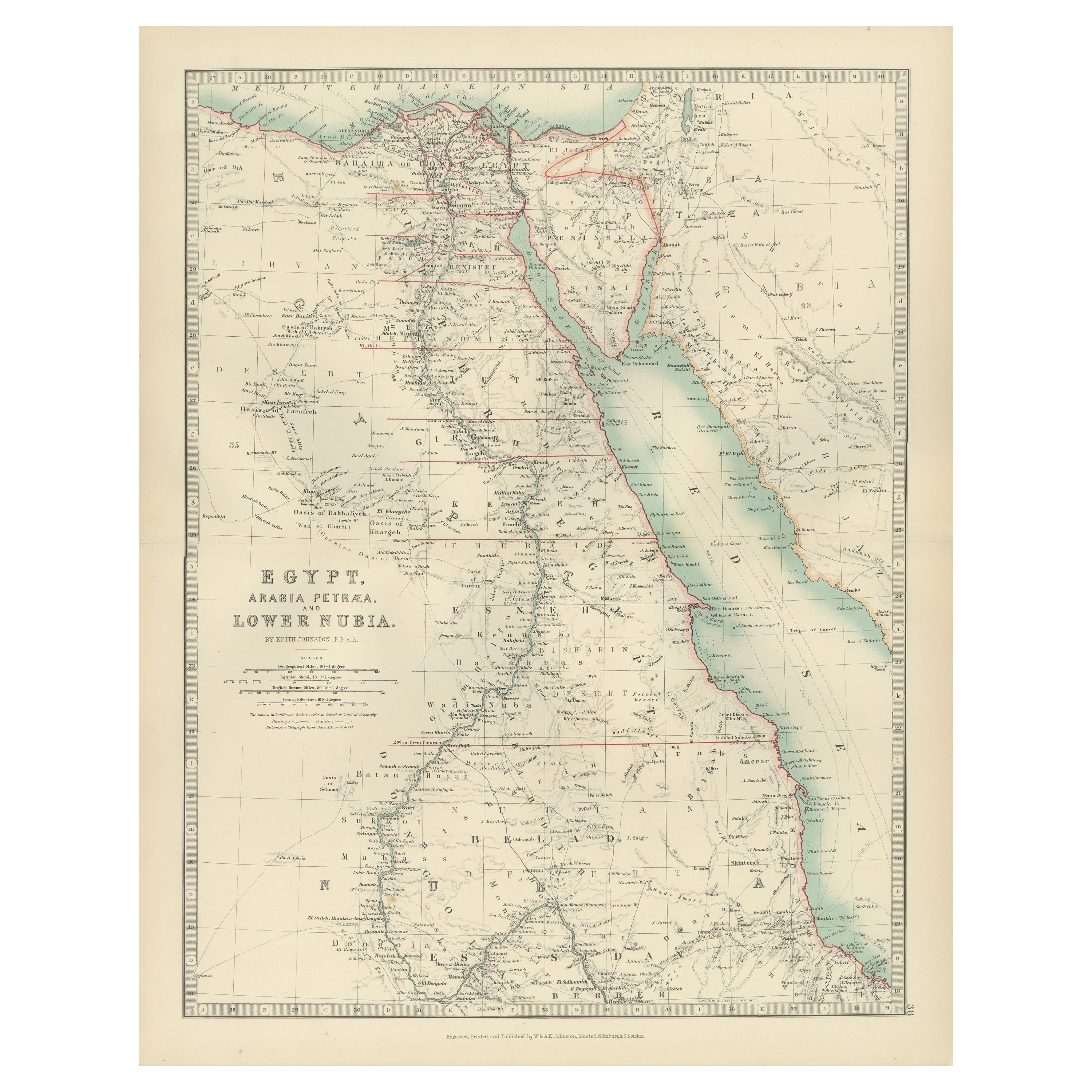
Ver todoMapa antiguo de Egipto, Arabia Petraea y Baja Nubia por Johnston
1909
Mapa antiguo titulado "Egipto, Arabia Petraea y Baja Nubia". Mapa antiguo original de Egipto, Arabia Petraea y Baja Nubia. Con mapas de Alejandría, El Cairo y el Canal de Suez. Este ...
Categoría
principios del siglo XX, Mapas
Materiales
Papel

188 € Precio de venta
Descuento del 24 %
Mapa antiguo del Antiguo Egipto que representa también el río Nilo y el Mar Rojo, 1845
Mapa antiguo Egipto titulado 'General Karte von Alt Aegypten von A.H. Brué'. Gran mapa de Egipto que representa también el río Nilo y el Mar Rojo. Fuente desconocida, por determinar....
Categoría
Antiguo, siglo XIX, Mapas
Materiales
Papel

Mapa antiguo de Egipto y Arabia Petraea por Lowry,
1852
Mapa antiguo titulado "Egipto y Arabia Petrea". Mapa original de Egipto y Arabia Petraea. Este mapa procede del "Atlas de Mesa de Lowry construido y grabado a partir de las Autoridad...
Categoría
Antiguo, Mediados del siglo XIX, Mapas
Materiales
Papel
80 € Precio de venta
Descuento del 20 %
Mapa antiguo de Egipto y Arabia Petraea por A
C. Black, 1870
Mapa antiguo titulado "Egipto y Arabia Petraea". Mapa antiguo original de Egipto y Arabia Petraea. Este mapa procede del "Atlas General del Mundo de Black". Publicado por A & C. Blac...
Categoría
Antiguo, Fines del siglo XIX, Mapas
Materiales
Papel

122 € Precio de venta
Descuento del 30 %
Egipto y Baja Nubia, 1903 - Mapa histórico que destaca el Nilo y el Mar Rojo
Egipto y Baja Nubia, 1903 - Mapa histórico que destaca el Nilo y el Mar Rojo
Este mapa bellamente detallado titulado "Egipto, Arabia Petraea y Baja Nubia" fue grabado, impreso y pub...
Categoría
principios del siglo XX, Mapas
Materiales
Papel
Mapa antiguo de Egipto y el Mar Rojo - Mapa detallado de 1865 de las regiones de Nubia y el Nilo
Mapa antiguo de Egipto, Nubia y la costa del Mar Rojo - Andriveau-Goujon, París 1865
Este mapa antiguo delicadamente coloreado, titulado *Partie du Cours du Nil comprenant l'Égypte,...
Categoría
Antiguo, Mediados del siglo XIX, Francés, Mapas
Materiales
Papel
También te puede gustar
Mapa de Tierra Santa "Carte de la Syrie et de l
Egypte" de Pierre Lapie
Por Pierre M. Lapie
Se trata de un mapa de la antigua Siria y Egipto de principios del siglo XIX titulado "Carte de la Syrie et de l'Egypte anciennes/dressée par M. Lapie, Colonel d'Etat Major, et M. La...
Categoría
Década de 1830, Impresiones de paisajes
Materiales
Grabado

Gran Mapa Vintage Original de Egipto, circa 1920
Gran mapa de Egipto
Sin enmarcar
Color original
Por John Bartholomew y Co. Instituto Geográfico de Edimburgo
Publicado, hacia 1920
Envío gratuito.
Categoría
Vintage, Década de 1920, Británico, Mapas
Materiales
Papel

África. Parte Noreste. Atlas del Siglo mapa antiguo de época
El Atlas del Siglo. África. Parte Noreste".
Mapa antiguo original, 1903.
Mapa en recuadro del "Delta del Nilo y Canal de Suez".
Pliegue central como se emitió. Nombre y número del ...
Categoría
principios del siglo XX, Victoriano, Más impresiones
Materiales
Litografía

Campagne d
Egypte - Aguafuerte de Pierre François Tardieu - 1837
Campagne d'Egypte es un Aguafuerte realizado por Pierre François Tardieu en 1837.
Buenas condiciones.
La obra está realizada en una composición bien equilibrada. la obra y pertenec...
Categoría
Década de 1830, Moderno, Impresiones figurativas
Materiales
Litografía
Mapa de Nubia y Abisinia - Grabado original de Antonio Zatta - 1784
Este Mapa de Nubia y Abisinia es un aguafuerte realizado por Antonio Zatta en Venecia en 1784.
El estado de conservación de la obra es bueno, salvo por el papel desgastado con algun...
Categoría
Década de 1770, Impresiones de paisajes
Materiales
Grabado químico

Mapa original antiguo de África por Dower, hacia 1835
Bonito mapa de África
Dibujado y grabado por J.Dower
Publicado por Orr & Smith. C.1835
Sin enmarcar.
Envío gratuito
Categoría
Antiguo, Década de 1830, Inglés, Mapas
Materiales
Papel
