Artículos similares a Holy Land Map of the Twelve Tribes of Israel, After Sanson, Paris c.1798


¿Quieres más imágenes o vídeos?
Solicita imágenes o vídeos adicionales al vendedor
1 de 9
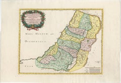
Holy Land Map of the Twelve Tribes of Israel, After Sanson, Paris c.1798
480 €IVA incluido
Acerca del artículo
Holy Land, Twelve Tribes of Israel – After Nicolas Sanson, De Vaugondy / Delamarche, c.1798
Description:
Holy Land. De Vaugondy (G. R.), Carte de la Terre des Hébreux ou Israélites, partagée selon l’Ordre de Dieu aux Douze Tribus descendantes des Douze Fils de Jacob. Paris, published by Charles-François Delamarche, circa 1798.
Large engraved biblical map of the Holy Land showing the division of the land among the Twelve Tribes of Israel, based on the cartography of Nicolas Sanson (1600–1667). The map depicts the territories west and east of the River Jordan, including Judah, Benjamin, Ephraim, Manasseh, Dan, Issachar, Zebulon, Asher, Naphtali, Reuben, and Gad, with cities, deserts, mountain ranges, and waterways carefully delineated.
This late 18th-century issue was published by Delamarche, successor to the Sanson and De Vaugondy cartographic tradition, and reflects continued European interest in biblical geography. The map is engraved on copper and finished with contemporary outline hand-coloring to distinguish the tribal boundaries. Decorative elements include an elaborate baroque cartouche and an inset map illustrating the lands east of the Jordan.
Condition:
Fair condition. Some creasing and surface wear. Old worming affecting the central fold, repaired from the verso. Tape and old reinforcements on the back. Light to moderate overall toning. No major loss to the engraved image.
Dimensions: 490 × 690 mm (approx. 19.3 × 27.2 inches)
Technique: Copper engraving with contemporary outline hand-coloring
Maker: After Nicolas Sanson; published by Charles-François Delamarche, Paris, circa 1798
- Dimensiones:Altura: 49 cm (19,3 in)Anchura: 69 cm (27,17 in)Profundidad: 0,2 mm (0,01 in)
- Materiales y técnicas:Papel,Grabado
- Lugar de origen:
- Época:
- Fecha de fabricación:circa 1798
- Estado:Reparado: Old worming affecting the central fold, repaired from the verso. Tape and old reinforcements on the back. Fair condition. Some creasing and surface wear. Old worming affecting the central fold, repaired from the verso. Tape and old reinforcements on the back. Light to moderate overall toning. No major loss to the engraved image.
- Ubicación del vendedor:Langweer, NL
- Número de referencia:Vendedor: BG-14152-31stDibs: LU3054348101602
Sobre el vendedor
5,0
Vendedor reconocido
Estos prestigiosos vendedores son líderes del sector y representan el escalón más alto en cuanto a calidad y diseño de artículos.
Vendedor Platino
Vendedores premium con una calificación de +4,7 y tiempos de respuesta de 24 horas
Establecido en 2009
Vendedor de 1stDibs desde 2017
2813 ventas en 1stDibs
Tiempo de respuesta usual: 1 hora
- EnvíoRecuperando presupuesto…Envío desde: Langweer, Países Bajos
- Política de devolución
Partes de esta página se han traducido automáticamente. 1stDibs no puede garantizar la exactitud de las traducciones. El inglés es el idioma predeterminado de este sitio web.
Más de este vendedor
Ver todoAntique French Map of the Holy Land, Twelve Tribes of Israel, c.1750
Antique Holy Land Map, Twelve Tribes of Israel – Robert de Vaugondy, c.1750
Description
This finely engraved and hand-colored map depicts Judea, or the Holy Land, divided according ...
Categoría
Antiguo, mediados del siglo XVIII, Francés, Mapas
Materiales
Papel
Antique Holy Land Map, Twelve Tribes of Israel – Covens
Mortier, c.1700
Antique Holy Land Map, Twelve Tribes of Israel – Covens
Mortier, c.1700
Description:
This finely engraved early 18th-century map depicts the Holy Land divided according to the...
Categoría
Antiguo, principios del siglo XVIII, Francés, Mapas
Materiales
Papel

Mapa de Tierra Santa de 1718 - Doce tribus, seis provincias, coloreado a mano, mapa antiguo
Título: Terra Sancta in XII olim Tribus nunc VI Provincias Dispertita
Cartógrafo: Christoph Weigel el Viejo (1654-1725)
Editor: Johann Ernst Adelbulner
Lugar y año de publicaci...
Categoría
Antiguo, Década de 1710, Alemán, Mapas
Materiales
Papel

Judaea or Terra Sancta, Twelve Tribes of Israel – Sanson Map, c.1680
Judaea or Terra Sancta, Twelve Tribes of Israel – Sanson Map, c.1680
This antique map depicts Judaea or the Holy Land divided among the Twelve Tribes of Israel, based on biblical ge...
Categoría
Antiguo, finales del siglo XVII, Holandés, Mapas
Materiales
Papel
Mapa antiguo muy detallado de Tierra Santa con las 12 tribus de Israel, c.1720
Mapa antiguo titulado 'Heylige Land verdeeld in de Twaalf Stammen Israels (..).'
Mapa muy detallado de la Tierra Santa dividida en 12 tribus de Israel. Con una hermosa cartela gr...
Categoría
Antiguo, Década de 1720, Mapas
Materiales
Papel

384 € Precio de venta
Descuento del 20 %
Envío gratuito
Holy Land Map of the Twelve Tribes of Israel – Sanson, Hand Colored, 1696
Holy Land Map of the Twelve Tribes of Israel – Sanson, Hand Colored, 1696
Description:
This impressive and richly hand-colored map of the Holy Land depicts the biblical territories ...
Categoría
Antiguo, finales del siglo XVII, Francés, Mapas
Materiales
Papel
También te puede gustar
Mapa Tierra Santa La Terre Sainte Grabado van Loon Publicado N de Fer 1703 Francés
La Terre Sainte, La Tierra Santa, Tiree Des Memoires De M.De.La Rue. Par N. de Fer. Geographe de Sa Majeste Catoliq et de Monseigneur le Dauphin. Avec Privil du Roi 1703
Mapa deta...
Categoría
Antiguo, Principios del 1700, Francés, Luis XIV, Mapas
Materiales
Papel

Antique French Map of Asia Including China Indoneseia India, 1783
Muy bonito mapa de Asia. 1783 Dedie au Roy.
Más información:
País de fabricación: Europa
Periodo: Siglo XVIII Qing (1661 - 1912)
Estado: Estado general B (Bien usado): Algunos rastr...
Categoría
Antiguo, siglo XVIII, Europeo, Mapas
Materiales
Papel

421 € Precio de venta
Descuento del 40 %
Antiguo mapa plegable de 1765 de Francia, Burdeos, etc.
Ruta de Carosse de Bordeaux, part de Paris tous les Mardis a 11 matin. a et pafse 1765 es un mapa completo con dos rutas por la región vinícola de Francia que comienza en París y v...
Categoría
Década de 1760, Otro estilo de arte, Impresiones de paisajes
Materiales
Grabado químico

Grecia Meridional: Un gran mapa coloreado a mano del siglo XVII por Sanson y Jaillot
Por Nicolas Sanson
Este gran mapa original grabado a mano en cobre del sur de Grecia y la península del Peloponeso, titulado "La Moree Et Les Isles De Zante, Cefalonie, Ste. Marie, Cerigo & C. Dresse S...
Categoría
Antiguo, Década de 1690, Francés, Mapas
Materiales
Papel

1367 € Precio de venta
Descuento del 20 %
Mapa del Reino de Cerdeña y parte del Reino de Génova, Roma
Por Giovanni Maria Cassini
Mapa del siglo XVIII del grabador italiano Giovanni Maria Cassini (Italia 1745-1824). Mapa de parte del reino de Cerdeña y parte del reino de Génova: Roma. Se trata de una estampa co...
Categoría
Antiguo, siglo XVIII, Italiano, Mapas
Materiales
Papel

688 € Precio de venta
Descuento del 36 %
Mapa Homann coloreado a mano del siglo XVIII del Mar Negro, Turquía y Asia Menor
Por Johann Baptist Homann
Atractivo mapa original coloreado a mano de principios del siglo XVIII del Mar Negro y Turquía, titulado "Carte de L'Asie Minevre ou de la Natolie et du Pont Evxin Tiree des Voyages ...
Categoría
Antiguo, principios del siglo XVIII, Alemán, Mapas
Materiales
Papel

605 € Precio de venta
Descuento del 20 %