Artículos similares a Jerusalem, Holy City View – Early Renaissance Woodcut, c.1560

¿Quieres más imágenes o vídeos?
Solicita imágenes o vídeos adicionales al vendedor
1 de 10
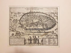
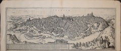
Jerusalem, Holy City View – Early Renaissance Woodcut, c.1560
620 €IVA incluido
Acerca del artículo
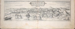
Jerusalem, Holy City View – Early Renaissance Woodcut, c.1560
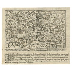
This rare and evocative Renaissance woodcut depicts the Holy City of Jerusalem as imagined in early modern Europe, shown as a fortified, densely built sacred city surrounded by hills, valleys, and biblical landmarks. The view presents Jerusalem as the spiritual and historical heart of the Holy Land, combining biblical tradition, medieval cartographic conventions, and early Renaissance city imagery.
The city is rendered in a panoramic bird’s-eye perspective, with major sacred sites clearly identified, including the Temple of Solomon, the Holy Sepulchre, Mount Zion, the Valley of Jehoshaphat, and the Garden of Gethsemane. Towers, gates, walls, domes, and churches fill the composition, creating a powerful visual narrative of Jerusalem as both an earthly city and a divine center. The emphasis is symbolic rather than topographically exact, reflecting how Jerusalem was understood and revered in 16th-century Christian Europe.
The French title at the top identifies Jerusalem as the former metropolitan city of the Kingdom of the Jews and notes its later status as a Roman colony, anchoring the image firmly within biblical and classical historical tradition. Below the city view, extensive French text discusses Jericho and biblical geography, accompanied by a decorative botanical woodcut, a characteristic feature of Renaissance cosmographical and biblical publications.
This print originates from a mid-16th-century French cosmographical or biblical work, influenced by Sebastian Münster and related Renaissance scholars. The woodcut technique, Gothic-Renaissance lettering, and dense narrative imagery place the print firmly within the great age of European biblical geography and early historical illustration.
Highly decorative and rich in symbolic detail, this view of Jerusalem is equally appealing to collectors of early Holy Land imagery, Renaissance prints, and biblical cartography, as well as to interior designers seeking a visually striking and intellectually layered historical work on paper.
Condition report
Good condition for a 16th-century woodcut. Central vertical fold as issued. General age toning and some discoloration consistent with period. Light creasing and minor edge wear. Text and image clear and well preserved. No major losses.
Framing tips
This print benefits from a wide off-white or light parchment-colored mat to emphasize the historic paper tone. A dark walnut, ebonized, or softly gilt frame enhances the Renaissance character and architectural detail. Particularly effective as a statement piece in a study, library, or classical interior.
Technique
Woodcut
Maker: Sebastian Münster (1488–1552) was a German cartographer/scholar, even when the book edition (and many surviving sheets) were printed in Basel and sometimes in French., c.1560
Keywords: Jerusalem, Holy Land, Holy City, Renaissance Jerusalem view, antique Jerusalem print, biblical Jerusalem, Holy Sepulchre, Temple of Solomon, Mount Zion, Gethsemane, Valley of Jehoshaphat, Jericho, biblical geography, early Holy Land map, 16th century woodcut, Renaissance woodcut, Sebastian Münster circle, antique religious print, Christian cartography, biblical city view, antique Israel print, Palestine, sacred geography, early modern cosmography
- Dimensiones:Altura: 30,5 cm (12,01 in)Anchura: 38,7 cm (15,24 in)Profundidad: 0,2 mm (0,01 in)
- Materiales y técnicas:Papel,Grabado
- Lugar de origen:
- Época:
- Fecha de fabricación:circa 1560
- Estado:Good condition for a 16th-century woodcut. Central vertical fold as issued. General age toning and some discoloration consistent with period. Light creasing and minor edge wear. Text and image clear and well preserved. No major losses.
- Ubicación del vendedor:Langweer, NL
- Número de referencia:Vendedor: BG-14153-41stDibs: LU3054348018012
Sobre el vendedor
5,0
Vendedor reconocido
Estos prestigiosos vendedores son líderes del sector y representan el escalón más alto en cuanto a calidad y diseño de artículos.
Vendedor Platino
Vendedores premium con una calificación de +4,7 y tiempos de respuesta de 24 horas
Establecido en 2009
Vendedor de 1stDibs desde 2017
2830 ventas en 1stDibs
Tiempo de respuesta usual: 1 hora
- EnvíoRecuperando presupuesto…Envío desde: Langweer, Países Bajos
- Política de devolución
Partes de esta página se han traducido automáticamente. 1stDibs no puede garantizar la exactitud de las traducciones. El inglés es el idioma predeterminado de este sitio web.
Más de este vendedor
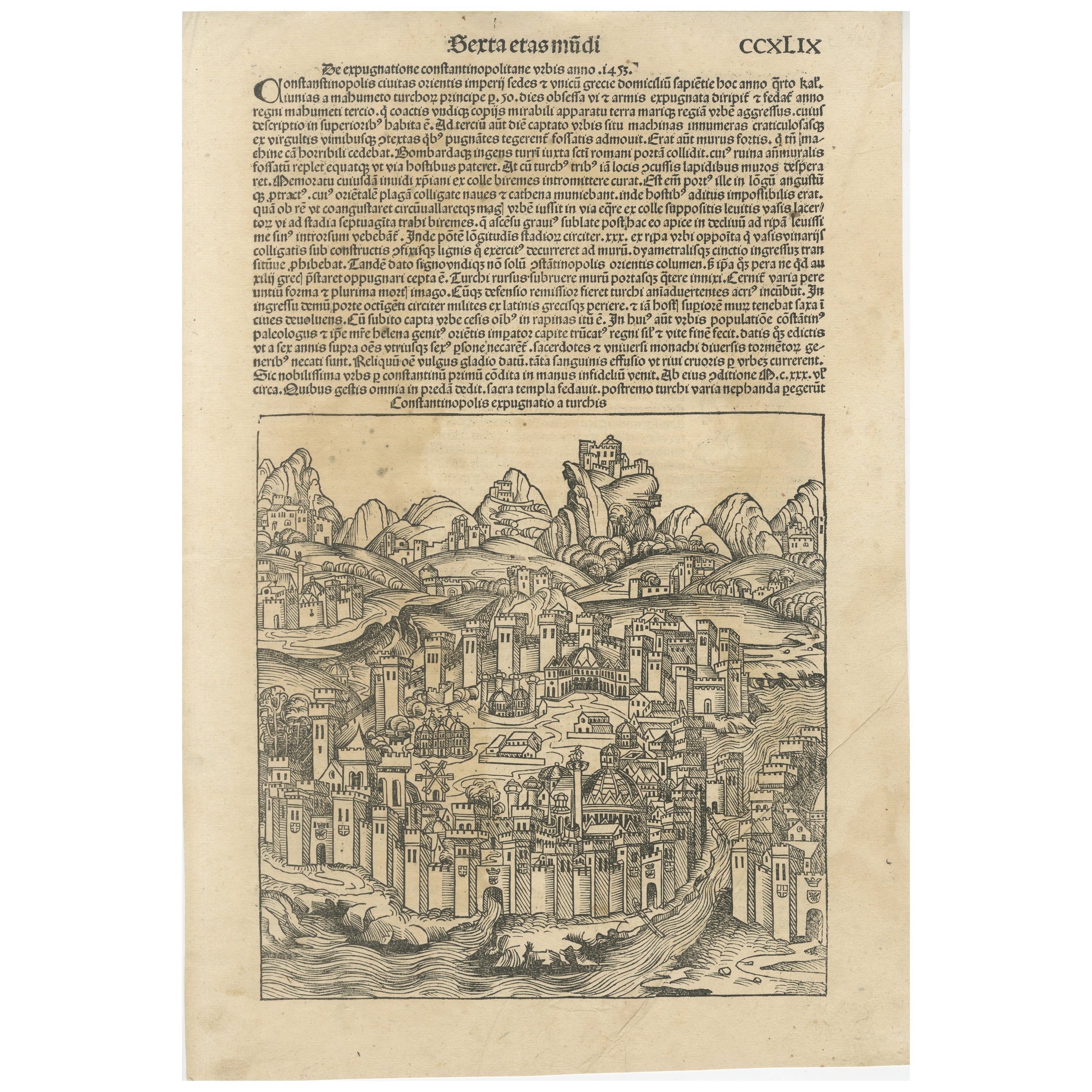
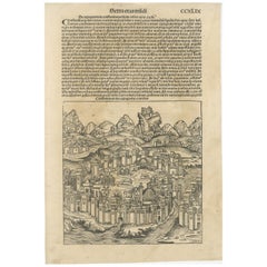
Ver todoRara xilografía de Constantinopla de 1493 de la Crónica de Núremberg de Hartmann Schedel
Título: Constantinopolis Expugnatio a Turchis - Hartmann Schedel, 1493
Esta vista xilográfica de Constantinopla procede de la "Crónica de Nuremberg" (Liber Chronicarum) de Hartmann ...
Categoría
Antiguo, siglo XV y antes, Alemán, Impresiones
Materiales
Papel
792 € Precio de venta
Descuento del 20 %
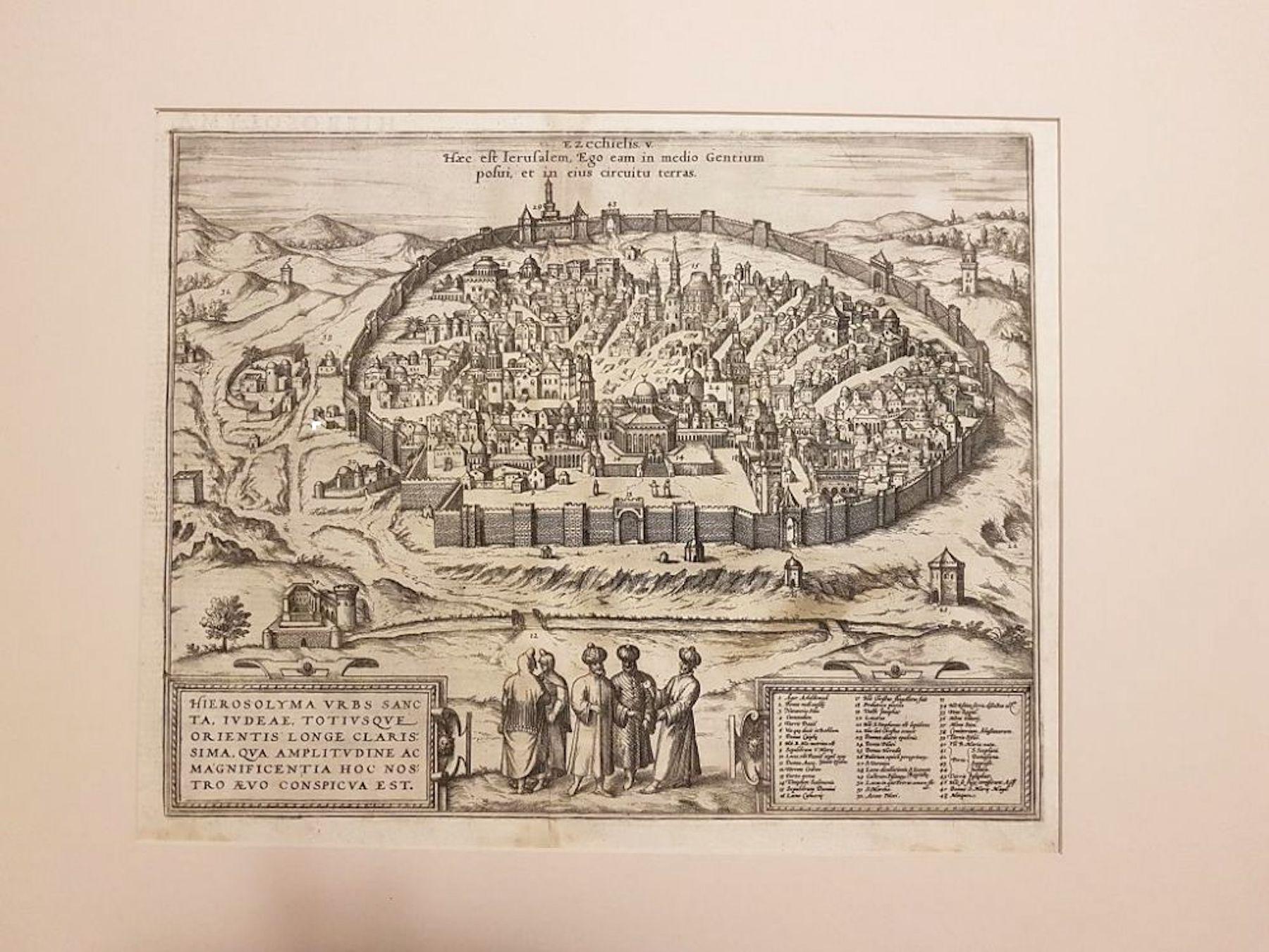
Grabado Weigel de Jerusalén de 1720: Una visión bíblica desde la perspectiva de Josefo
Mapa Weigel de Jerusalén de 1720 basado en los escritos de Josefo
Este intrincado mapa a vista de pájaro de la antigua Jerusalén de 1720, obra de I.H. Coccejo, grabado por Christ...
Categoría
Antiguo, Década de 1720, Mapas
Materiales
Papel

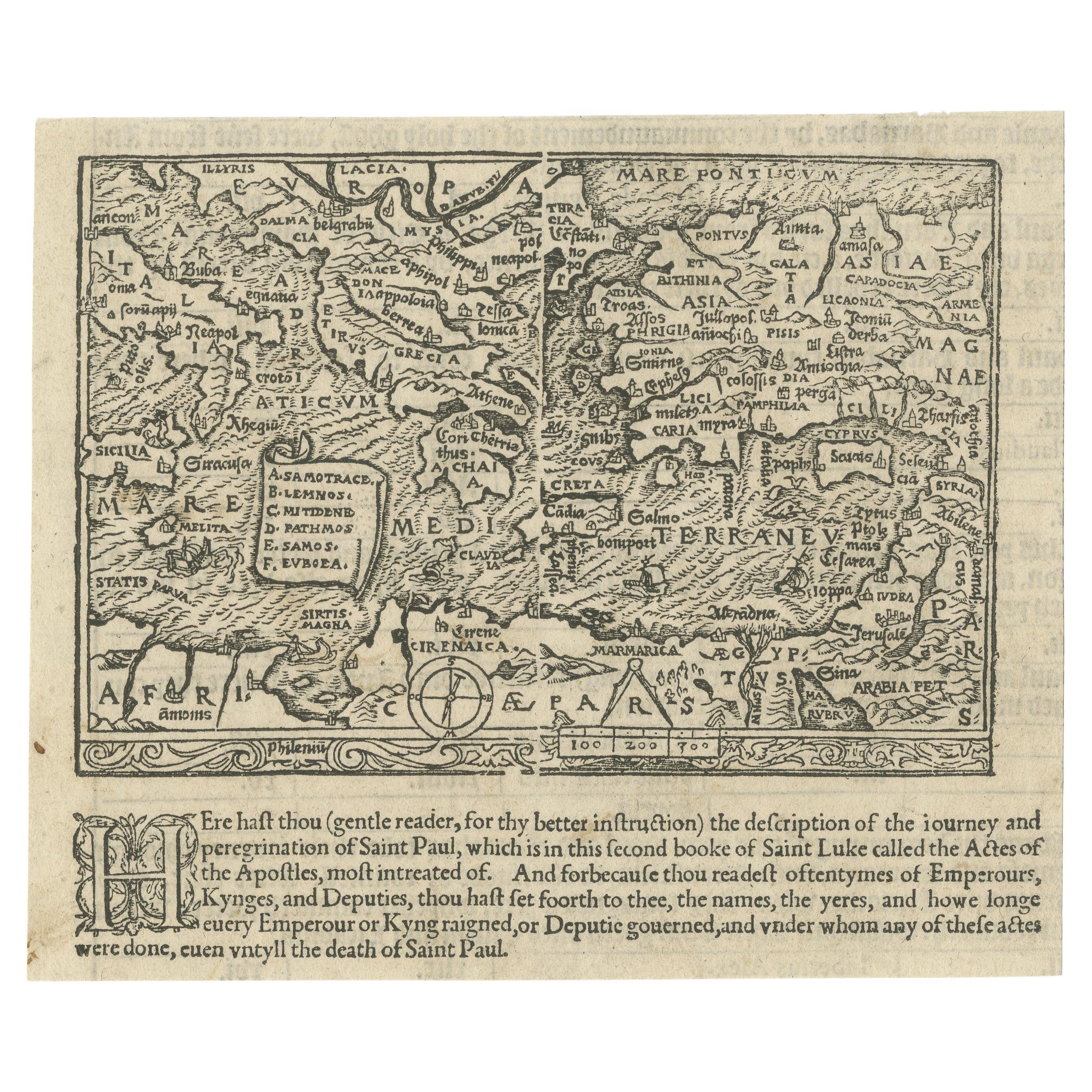
Raro e Interesante Pequeño Mapa Xilográfico Antiguo del Mediterráneo, 1568
Rarísimo mapa xilográfico antiguo sin título que muestra la región de los viajes misioneros del apóstol Pablo. Muestra el Mediterráneo con Grecia, Asia Menor (Turquía), el norte de Á...
Categoría
Antiguo, siglo XVI, Británico, Mapas
Materiales
Papel
2100 € Precio de venta
Descuento del 25 %
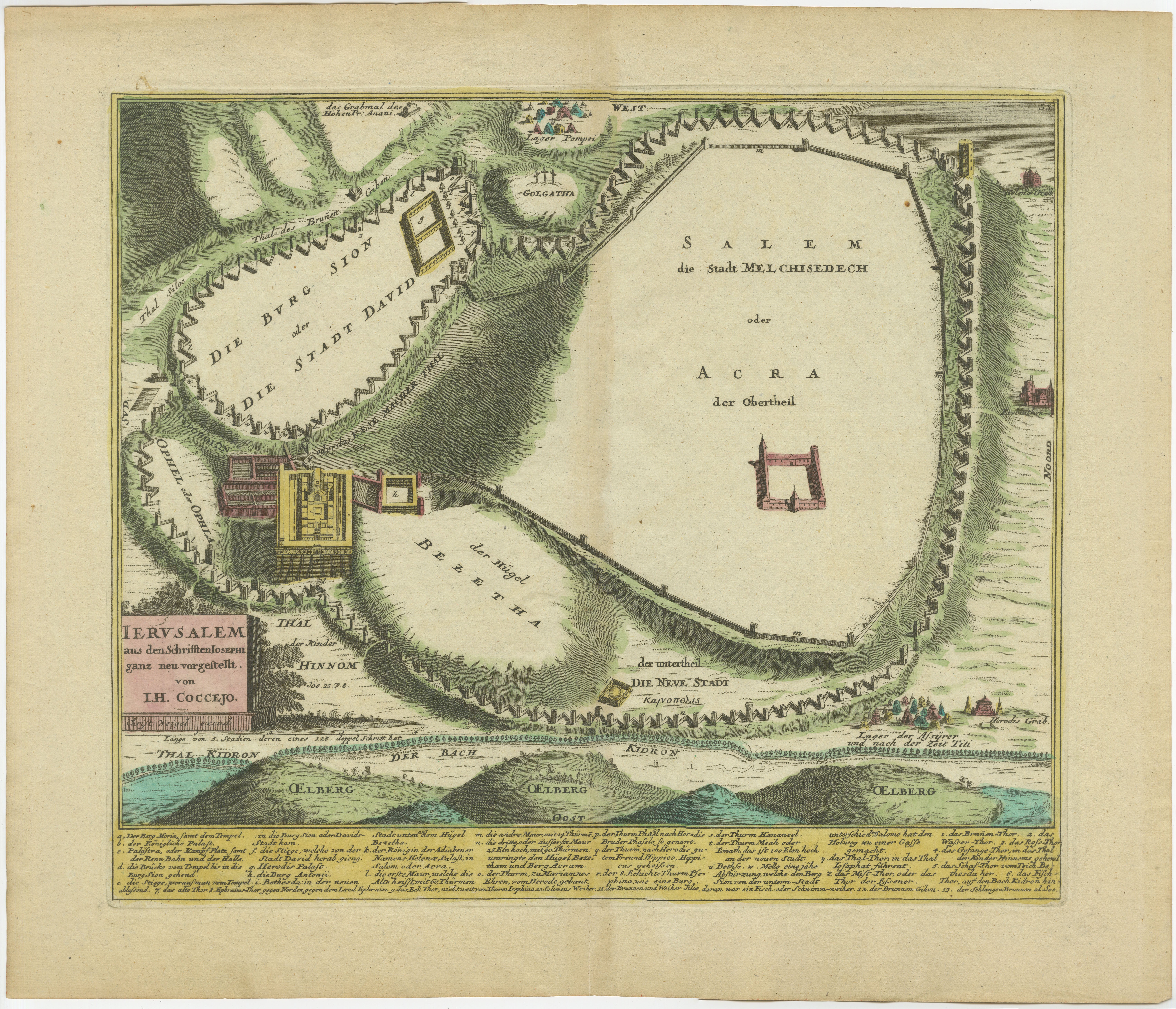
Espectacular grabado original antiguo de un plano urbano de Jerusalén, 1708
Descripción: Mapa antiguo titulado 'Erster Abriss der Stadt Jerusalem wie sie Furnemblich zur Zeit des Hernn Christi beschaffen (..).'
Espectacular plano urbano de Jerusalén, bas...
Categoría
Antiguo, Principios del 1700, Mapas
Materiales
Papel

Paisaje urbano de Huy (Huum) 1574: Grabado histórico en cobre de Braun
Hogenberg
Título: Huum opp. condrusorum caput (...) Anno partae salutis 1574.
**Tipo:** Impresión (Grabado en cobre coloreado)
**Año:** circa 1580
**Técnica:** Grabado en cobre coloreado
**M...
Categoría
Antiguo, siglo XVI, Mapas
Materiales
Papel
512 € Precio de venta
Descuento del 20 %
Mapa antiguo de Tierra Santa, con viñeta del Jardín del Edén
Mapa antiguo titulado "Hondius su Mapa del Paraíso". Precioso mapa de la región delimitada por Tierra Santa. Siria, Mesopotamia, Caldea y parte de Arabia. Con viñeta decorativa del J...
Categoría
Antiguo, mediados del siglo XVII, Mapas
Materiales
Papel
384 € Precio de venta
Descuento del 20 %
También te puede gustar
Jerusalén, Mapa antiguo de "Civitates Orbis Terrarum" - 1572-1617
Por Franz Hogenberg
Braun G., Hogenberg F., Jerusalén, de la colección Civitates Orbis Terrarum, Colonia, T. Graminaeus, 1572-1617.
Dimensiones de la imagen: cm 32,8 x 41; dimensiones: cm 41 x 54; dime...
Categoría
siglo XVI, Impresiones de paisajes
Materiales
Grabado químico
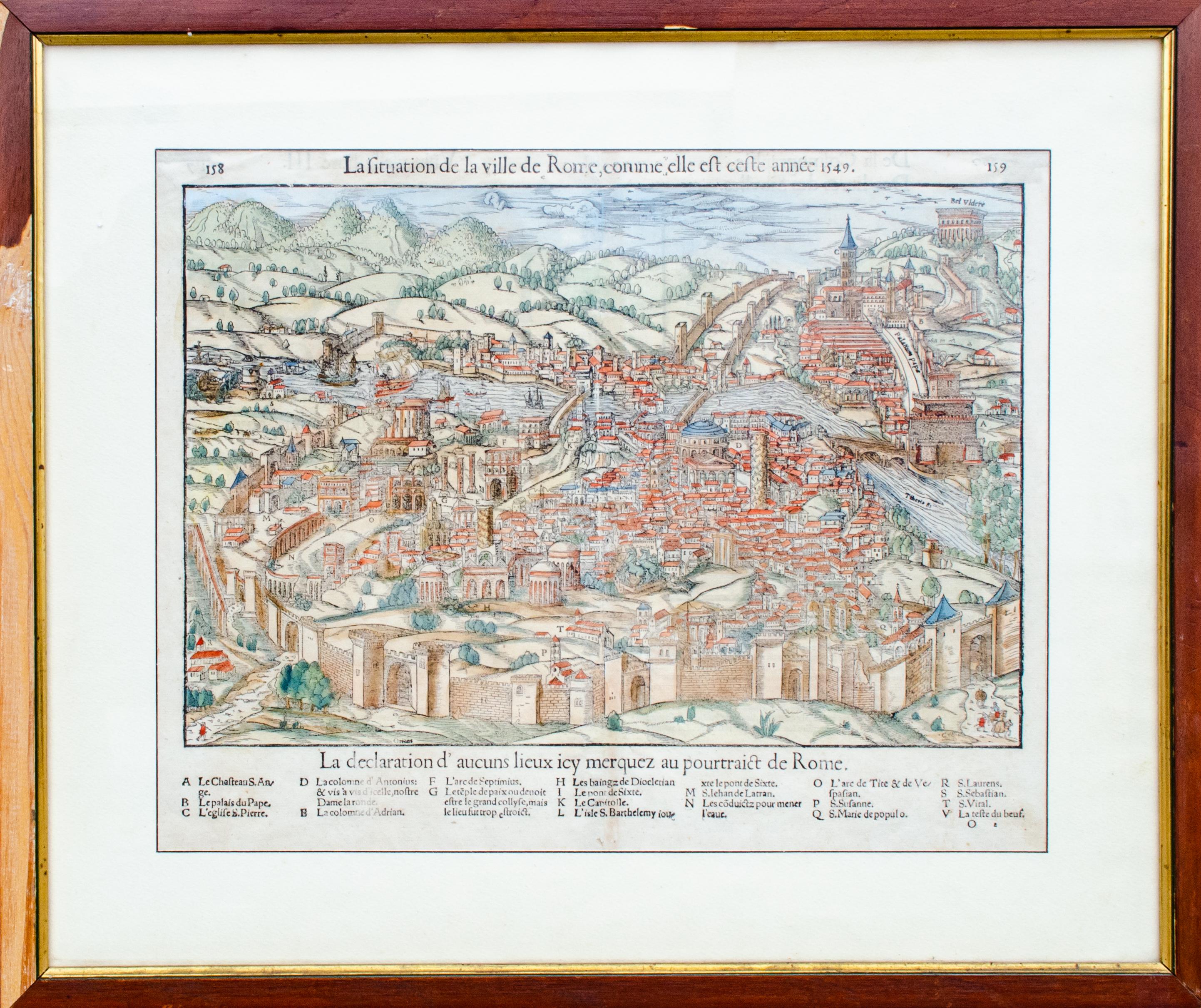
Mapa antiguo de la ciudad de Roma por Sebastian Münster, 1549
Por Sebastian Münster
Sebastian Münster (alemán, 1488-1552)
LA SITUACIÓN DE LA CIUDAD DE ROMA
Mapa antiguo de Roma, 1549
Posiblemente impreso en 1964
Imprimir en papel
Editorial: Heinrich Petri para Cosm...
Categoría
Década de 1960, Realista, Impresiones figurativas
Materiales
Grabado en madera
Toledo, Mapa de "Civitates Orbis Terrarum" - por F. Hogenberg - 1575
Por Franz Hogenberg
Braun G., Hogenberg F., "Toledo", de la colección "Civitates Orbis Terrarum", Colonia, T. Graminaeus, 1572-1617. Imagen Dim: cm 19 x 48 , Dim: cm 22. 5 x 52.5 .
Aguatinta en B/N muy...
Categoría
siglo XVI, Impresiones figurativas
Materiales
Grabado químico, Acuatinta
Mapa de Nemavsus - Grabado de George Braun - Finales del siglo XVI
Este Mapa de Nemavsus es un aguafuerte original realizado por George Braun (1541 - 1622)
El estado de conservación de la obra es bueno y está envejecida en los bordes de la hoja, c...
Categoría
siglo XVI, Más impresiones
Materiales
Grabado químico
Granada, Mapa de "Civitates Orbis Terrarum" - por F.Hogenberg - 1575
Por Franz Hogenberg
"Granada", de la colección "Civitates Orbis Terrarum", Colonia, T. Graminaeus, 1575.
Muy bonito Aguatinta en B/N, que representa una Vista de Granada, desde el Este, que fue quizá...
Categoría
siglo XVI, Impresiones figurativas
Materiales
Grabado químico, Acuatinta
Buda, Mapa antiguo de "Civitates Orbis Terrarum" - 1572-1617
Por Franz Hogenberg
Braun G., Hogenberg F., Buda, de la colección Civitates Orbis Terrarum, Colonia, T. Graminaeus, 1572-1617.
Aguatinta B/N muy fina que muestra una vista de Buda, una parte actual de ...
Categoría
siglo XVI, Impresiones de paisajes
Materiales
Grabado químico