Artículos similares a Ottoman Empire Map 1719 – Europe Asia Africa, Jean Chiquet, Paris

¿Quieres más imágenes o vídeos?
Solicita imágenes o vídeos adicionales al vendedor
1 de 9
Ottoman Empire Map 1719 – Europe Asia Africa, Jean Chiquet, Paris
470 €IVA incluido
Acerca del artículo
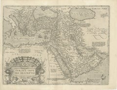
Title: Ottoman Empire Map 1719 – Europe Asia Africa, Jean Chiquet, Paris
Description:
Original early-18th-century engraved map titled Estats de l’Empire du Grand Seigneur, depicting the Ottoman Empire across three continents: Europe, Asia, and Africa. This example is clearly dated 1719 in the engraved cartouche and bears the publisher’s imprint Chez Jacq. Chiquet à Paris 1719.
The map presents the Ottoman Empire at an early Enlightenment moment, extending from Central and Southeastern Europe through Anatolia and the Levant, across Mesopotamia and Arabia, and into Egypt and the North African Barbary Coast. Political regions are defined by engraved boundaries and differentiated with original hand coloring, while coastlines, rivers, and seas are rendered with strong copper engraving typical of early 18th-century French map production.
French toponymy is dense and legible, with major cities and regions clearly identified, including Constantinople, Aleppo, Damascus, Baghdad, Cairo, Mecca, and Jerusalem. The Mediterranean, Black Sea, Red Sea, and Caspian Sea anchor the composition and emphasize the empire’s strategic maritime reach.
The decorative cartouche at upper right contains the full title and date, identifying the Ottoman ruler as “Grand Seigneur,” Sultan and Emperor of the Turks, ruling territories in Europe, Asia, and Africa. A lower table listing Ottoman rulers reinforces the political and didactic purpose of the map, which was intended both for geographic reference and informed private collecting.
Issued by Jean Chiquet, a Parisian map seller active in the early 18th century, this map reflects the commercial dissemination of authoritative geographic models during the reign of Louis XV. It combines political clarity with restrained decorative appeal, making it equally suitable for scholarly collections and interior display.
Condition report:
Copper engraving with original hand coloring. Age-related toning and light spotting consistent with an early 18th-century print. Minor edge wear and small handling marks, mainly in the margins. Plate mark visible. No major losses or repairs. Overall very good condition for a map dated 1719.
Framing tips:
Preserve the full margins and visible plate mark with a wide ivory or parchment-toned mat. A walnut, ebonized wood, or muted antique gold frame complements the period character. For a cleaner contemporary look, use a slim black frame with generous off-white matting.
SEO keyword block:
Ottoman Empire map 1719, antique Ottoman map, Jean Chiquet map, Middle East map 18th century, Holy Land map antique, Arabia map 1719, Turkey map antique, Islamic world map, French engraved map, hand colored antique map, Europe Asia Africa map
Technique: Copper engraving with original hand coloring
Maker: Jean Chiquet, Paris, 1719
- Dimensiones:Altura: 20,6 cm (8,12 in)Anchura: 27,8 cm (10,95 in)Profundidad: 0,2 mm (0,01 in)
- Materiales y técnicas:Papel,Grabado
- Lugar de origen:
- Época:
- Fecha de fabricación:1719
- Estado:Copper engraving with original hand coloring. Age-related toning and light spotting consistent with an early 18th-century print. Minor edge wear and small handling marks, mainly in the margins. Plate mark visible. No major losses or repairs.
- Ubicación del vendedor:Langweer, NL
- Número de referencia:Vendedor: BG-141971stDibs: LU3054348065702
Sobre el vendedor
5,0
Vendedor reconocido
Estos prestigiosos vendedores son líderes del sector y representan el escalón más alto en cuanto a calidad y diseño de artículos.
Vendedor Platino
Vendedores premium con una calificación de +4,7 y tiempos de respuesta de 24 horas
Establecido en 2009
Vendedor de 1stDibs desde 2017
2811 ventas en 1stDibs
Tiempo de respuesta usual: 1 hora
- EnvíoRecuperando presupuesto…Envío desde: Langweer, Países Bajos
- Política de devolución
Partes de esta página se han traducido automáticamente. 1stDibs no puede garantizar la exactitud de las traducciones. El inglés es el idioma predeterminado de este sitio web.
Más de este vendedor
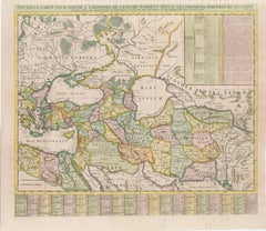
Ver todoMapa del Imperio Romano de Oriente del siglo XVIII, por Henri Chatelain, c. 1719
Título: Mapa del Imperio Romano de Oriente del siglo XVIII por Henri Chatelain, c. 1719
Descripción: Este mapa intrincadamente detallado, titulado *Nouvelle Carte pour Servir à l'Hi...
Categoría
Antiguo, Década de 1710, Mapas
Materiales
Papel
Mapa histórico finamente grabado de Oriente Medio y Asia, c.1745
Descripción: Mapa antiguo titulado "Theatrum Historicum pars Orientalis".
Mapa histórico finamente grabado con profusión de detalles. Muestra Oriente Medio y Asia. En el ángulo s...
Categoría
Antiguo, Década de 1740, Mapas
Materiales
Papel

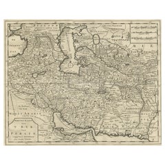
Mapa de Persia, el Caspio y la India - Isaak Tirion, c.1730
Mapa de Persia y regiones circundantes - "Nieuwe Kaart van 't Ryck van Persie" de Isaak Tirion, Amsterdam, c. 1730
Este mapa de cobre finamente detallado titulado "Nieuwe Kaart van ...
Categoría
Antiguo, mediados del siglo XVIII, Holandés, Mapas
Materiales
Papel
Mapa Antiguo Original Detallado del Imperio Turco con Arabia, 1778
Título: Etats Due Grand-Seigneur En Asie, Empire De Perse, Pays Des Usbecs, Arabie et Egypte . . . 1753
Mapa detallado del Imperio Turco, que se extiende hasta el Mar Negro, Georg...
Categoría
Antiguo, Década de 1770, Francés, Mapas
Materiales
Papel

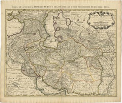
1742 Mapa antiguo del Imperio Persa con bordes y cartuchos detallados
Título: Mapa Covens & Mortier del Imperio Persa de 1742 por Guillaume De L'Isle
Este notable mapa de 1742, "Carte de Perse", fue diseñado originalmente por Guillaume De L'Isle, pr...
Categoría
Antiguo, Década de 1740, Holandés, Mapas
Materiales
Papel
1296 € Precio de venta
Descuento del 20 %
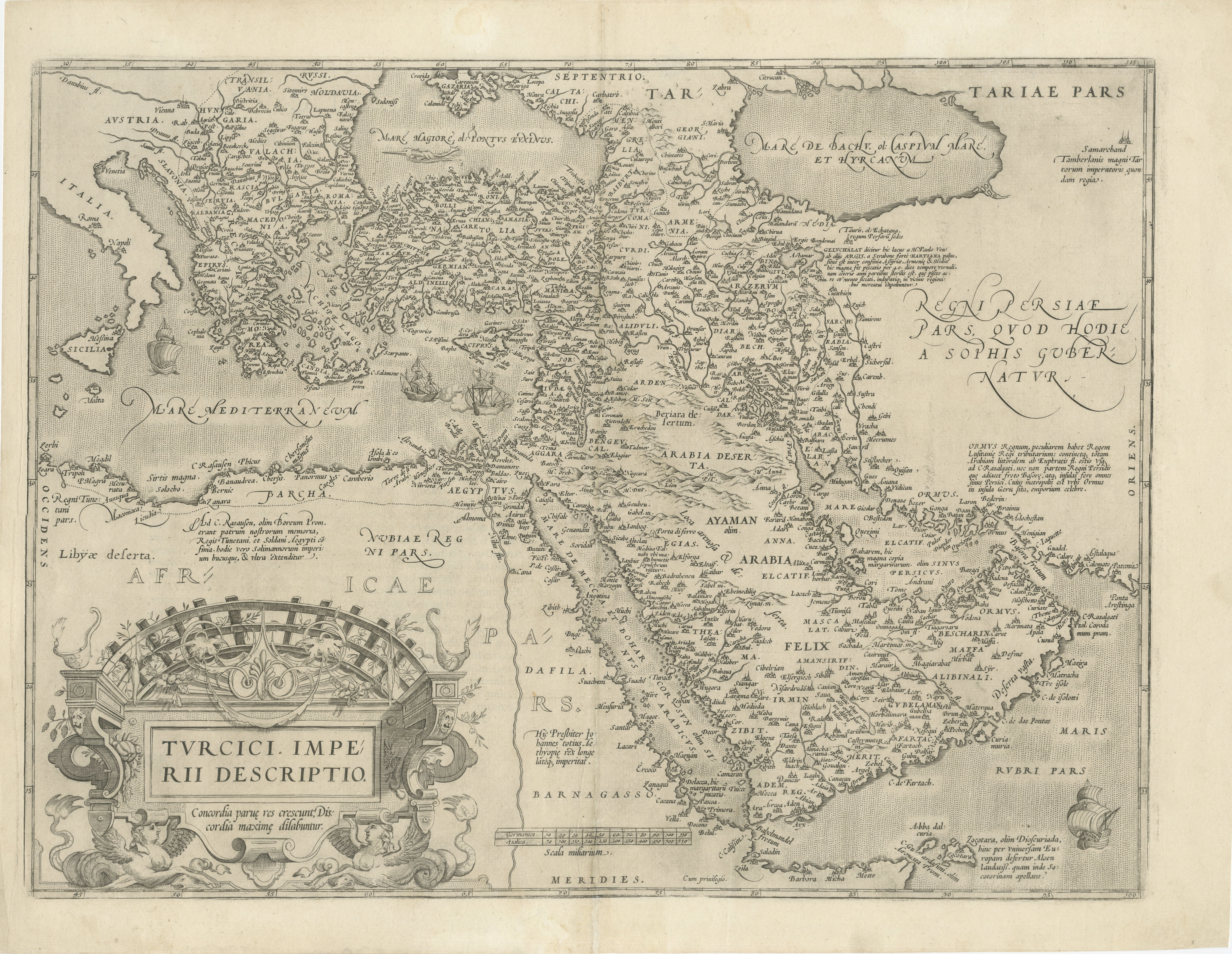
Mapa del siglo XVI del Imperio Otomano y Oriente Próximo: Turcici Imperii Descriptio
Título: Mapa original del siglo XVI del Imperio Otomano y Oriente Próximo: *Turcici Imperii Descriptio* de Ortelius, 1571
Este raro grabado en cobre, Turcici Imperii Descriptio, e...
Categoría
Antiguo, siglo XVI, Europeo, Mapas
Materiales
Papel
1280 € Precio de venta
Descuento del 20 %
También te puede gustar
Antique French Map of Asia Including China Indoneseia India, 1783
Muy bonito mapa de Asia. 1783 Dedie au Roy.
Más información:
País de fabricación: Europa
Periodo: Siglo XVIII Qing (1661 - 1912)
Estado: Estado general B (Bien usado): Algunos rastr...
Categoría
Antiguo, siglo XVIII, Europeo, Mapas
Materiales
Papel

421 € Precio de venta
Descuento del 40 %
1718 Mapa Ides
Witsen "Route D
amsterdam a Moscow Et De La Ispahan Et Gamron
Mapa de Ides & Witsen de 1718, titulado
"Route D'Amsterdam A Moscow Et De La Ispahan Et Gamron".
Ric.b005
Tema: Europa del Este y Asia Central
Periodo: 1718 (publicado)
Publi...
Categoría
Antiguo, principios del siglo XVIII, Holandés, Mapas
Materiales
Papel

Europa Meridional y Oriental: Un gran mapa del siglo XVII coloreado a mano por Sanson
Jaillot
Por Nicolas Sanson
Este gran mapa coloreado a mano titulado "Estats de L'Empire des Turqs en Europe, ou sont les Beglerbeglicz our Gouvernements" fue creado originalmente por Nicholas Sanson d'Abbevill...
Categoría
Antiguo, Década de 1690, Francés, Mapas
Materiales
Papel

1507 € Precio de venta
Descuento del 20 %
Persia, Armenia y Regiones Adyacentes: Un mapa coloreado a mano del siglo XVII por De Wit
Por Frederick de Wit
Gran mapa grabado en cobre coloreado a mano del siglo XVII titulado "Novissima nec non Perfectissima Scandinaviae Tabula comprehendens Regnorum Sueciae, Daniae et Norvegiae distincte...
Categoría
Antiguo, finales del siglo XVII, Holandés, Mapas
Materiales
Papel

1299 € Precio de venta
Descuento del 20 %
Persiae, Armeniae, Natoliae et Arabiae Descriptio per Frederick deWit 1666 mapa
Mapa de Persiae, Armeniae, Natoliae et Arabiae Descriptio per F de Wit 1688 grabado de: Atlas Contractus Orbis Terrarum Praecipuas ac Novissimas Complectens Tabulas. Amsterdam, ...
Categoría
Década de 1660, Realista, Impresiones de paisajes
Materiales
Grabado

Mapa de las Indias Orientales: Un mapa original coloreado a mano del siglo XVIII por E. Bowen
Se trata de un mapa original coloreado a mano del siglo XVIII titulado "Un mapa preciso de las Indias Orientales que muestra el curso del comercio europeo tanto en el continente como...
Categoría
mediados del siglo XVIII, Antiguos maestros, Impresiones de paisajes
Materiales
Grabado

883 € Precio de venta
Descuento del 20 %