Articles similaires à Animal Distribution Map by A.K. Johnston – Fauna by Climate Zones 1852


Vous voulez plus d
images ou de vidéos ?
Demander au vendeur plus d
images ou de vidéos
1 sur 11
Animal Distribution Map by A.K. Johnston – Fauna by Climate Zones 1852
260 €par article|TVA incluse
Quantité
À propos de cet article
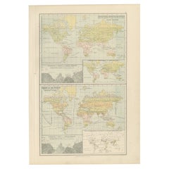
Animal Distribution Map by A.K. Johnston – Fauna by Climate Zones 1852
This beautifully engraved chart titled "The Distribution of Animals Including the Mammalia, Birds, Reptiles
Fishes; According to Zones of Climate" was created by Alexander Keith Johnston and published in 1852 by William Blackwood
Sons, Edinburgh and London. It appears as Plate 16 in Johnston’s influential *Physical Atlas of Natural Phenomena*, one of the most important thematic atlases of the 19th century.
This map presents a global view of the natural distribution of animals based on climatic zones, highlighting how temperature, geography, and elevation influence animal habitats. The world is divided into major climate zones such as the "Temperate Fauna," "Tropical Fauna," and "Zones of Perpetual Ice and Snow," with red typography identifying characteristic species of mammals, birds, reptiles, and marine life in each region.
Notable animal groups are labeled in situ, such as the polar bear, right whale, llama, lion, elephant, condor, kangaroo, and reindeer. Faunal regions across Asia, Africa, the Americas, Australia, and the Arctic are described in broad zoological terms. The map distinguishes between terrestrial and marine fauna, with references to oceanic zones for species like whales and seals, while also noting elevation-related changes in animal life.
Beneath the main map is a detailed comparative diagram titled "Distribution of Animals in a Vertical Direction," showing how animal species vary with altitude across major mountain systems in the Western and Eastern Hemispheres. Mountains like the Andes, Alps, Himalayas, and the Rocky Mountains are illustrated with fauna labeled at different heights—from mountain goats and condors to tigers and leopards—illustrating the vertical stratification of animal habitats.
Alexander Keith Johnston (1804–1871) was a pioneer in thematic cartography and served as Geographer in Ordinary to Queen Victoria. His *Physical Atlas* combined scientific rigor with visual clarity and artistic precision, making complex environmental and biological data both accessible and visually compelling.
This plate is ideal for collectors of natural history, early zoological science, or antique educational prints. It also serves as an elegant decorative piece for libraries, studies, or offices with a scientific or historical theme.
Condition and framing tips:
Very good condition with mild age toning and a clean image area. Original centerfold present. Frame in dark wood or black with a neutral or ivory mat to enhance the subtle red and green tones and the delicate engravings. A fine piece for natural history enthusiasts and vintage map collectors alike.
- Dimensions:Hauteur : 27,4 cm (10,79 po)Largeur : 34,5 cm (13,59 po)Profondeur : 0,2 mm (0,01 po)
- Matériaux et techniques:
- Lieu d origine:
- Période:
- Date de fabrication:1852
- État:Very good condition. Light overall toning near the margins and some offset over Europe. The paper remains strong and well-preserved. Folding line as issued.
- Adresse du vendeur:Langweer, NL
- Numéro de référence:Vendeur : BG-13207-161stDibs : LU3054345393532
À propos du vendeur
5,0
Vendeur reconnu
Ces vendeurs prestigieux sont des leaders du secteur. Ils représentent le summum en matière de qualité et de design.
Vendeur Platine
Vendeurs premium dont la note est supérieure à 4,7 et le délai de réponse de 24 heures maximum
Établi en 2009
Vendeur 1stDibs depuis 2017
2 800 ventes sur 1stDibs
Temps de réponse habituel : <1 heure
- ExpéditionRecherche du devis...Expédition depuis : Langweer, Pays-Bas
- Politique des retours
Certaines parties de cette page ont été traduites automatiquement. 1stDibs ne garantit pas l
exactitude des traductions. L
anglais est la langue par défaut de ce site web.
Plus d articles de ce vendeur
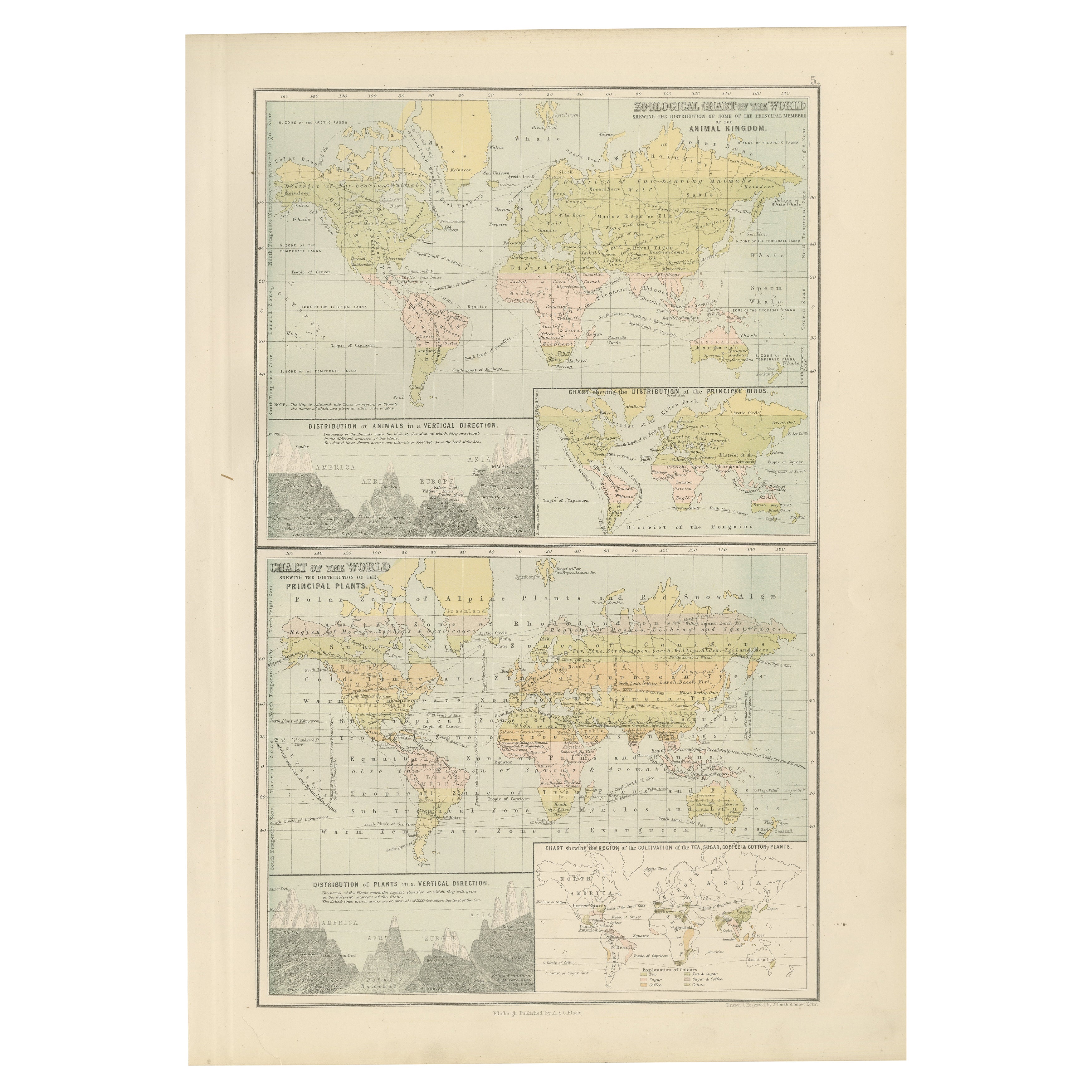
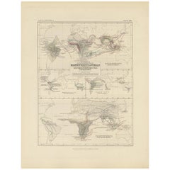
Tout afficherCarte ancienne montrant la division et la distribution des mammouths par Johnston
1850
Carte ancienne intitulée "Geographical division and distribution of mammiferous animals of the orders rodentia and ruminantia over the globe". Carte ancienne originale montrant la di...
Catégorie
Antiquités, Milieu du XIXe siècle, Cartes
Matériaux
Papier

160 € Prix de vente
20 % de remise
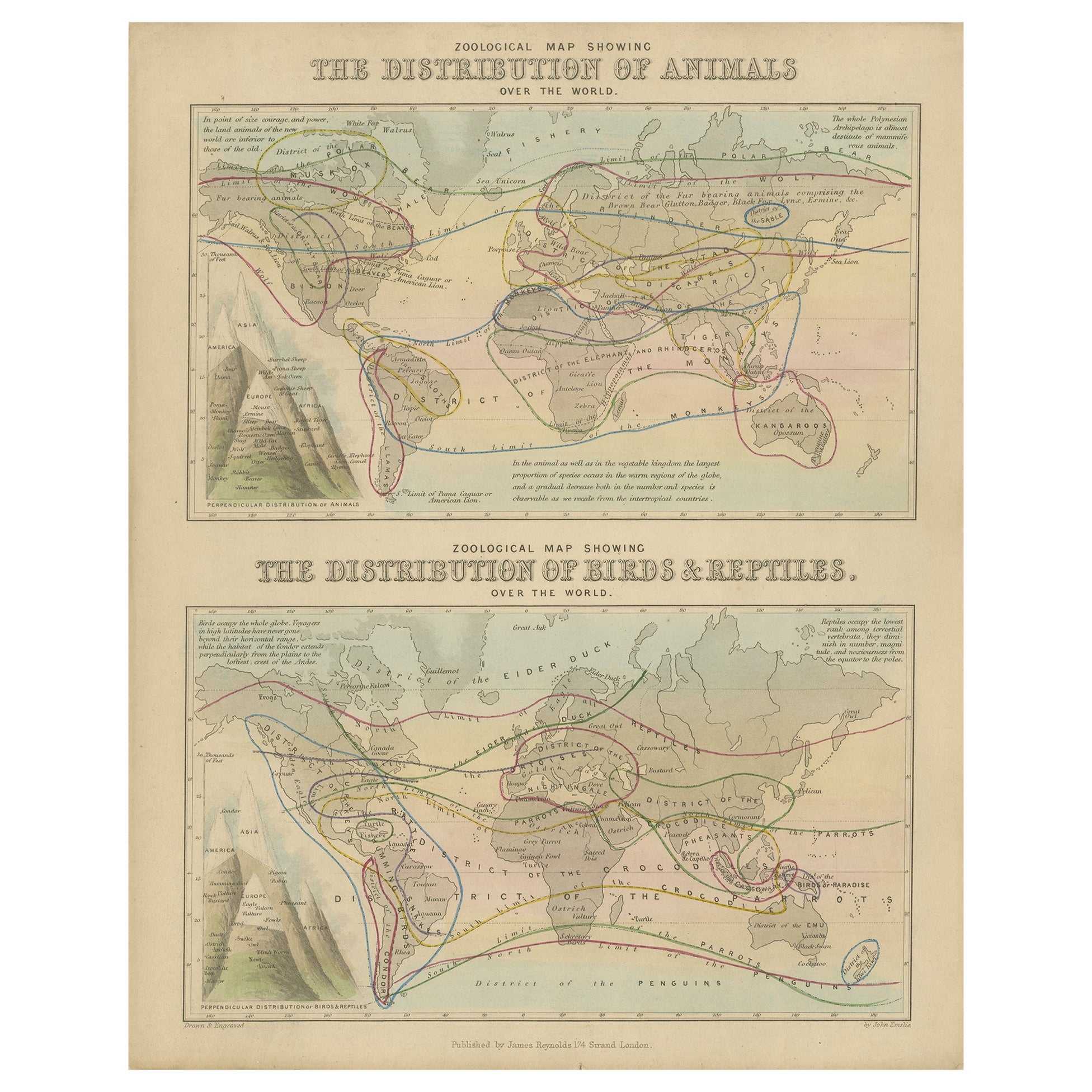
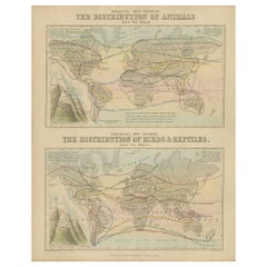
Carte zoologique ancienne, 1843
Deux cartes du monde anciennes sur une seule feuille. La carte supérieure montre la répartition des animaux dans le monde. La carte du bas montre la répartition des oiseaux et des re...
Catégorie
Antiquités, XIXe siècle, Cartes
Matériaux
Papier
176 € Prix de vente
20 % de remise
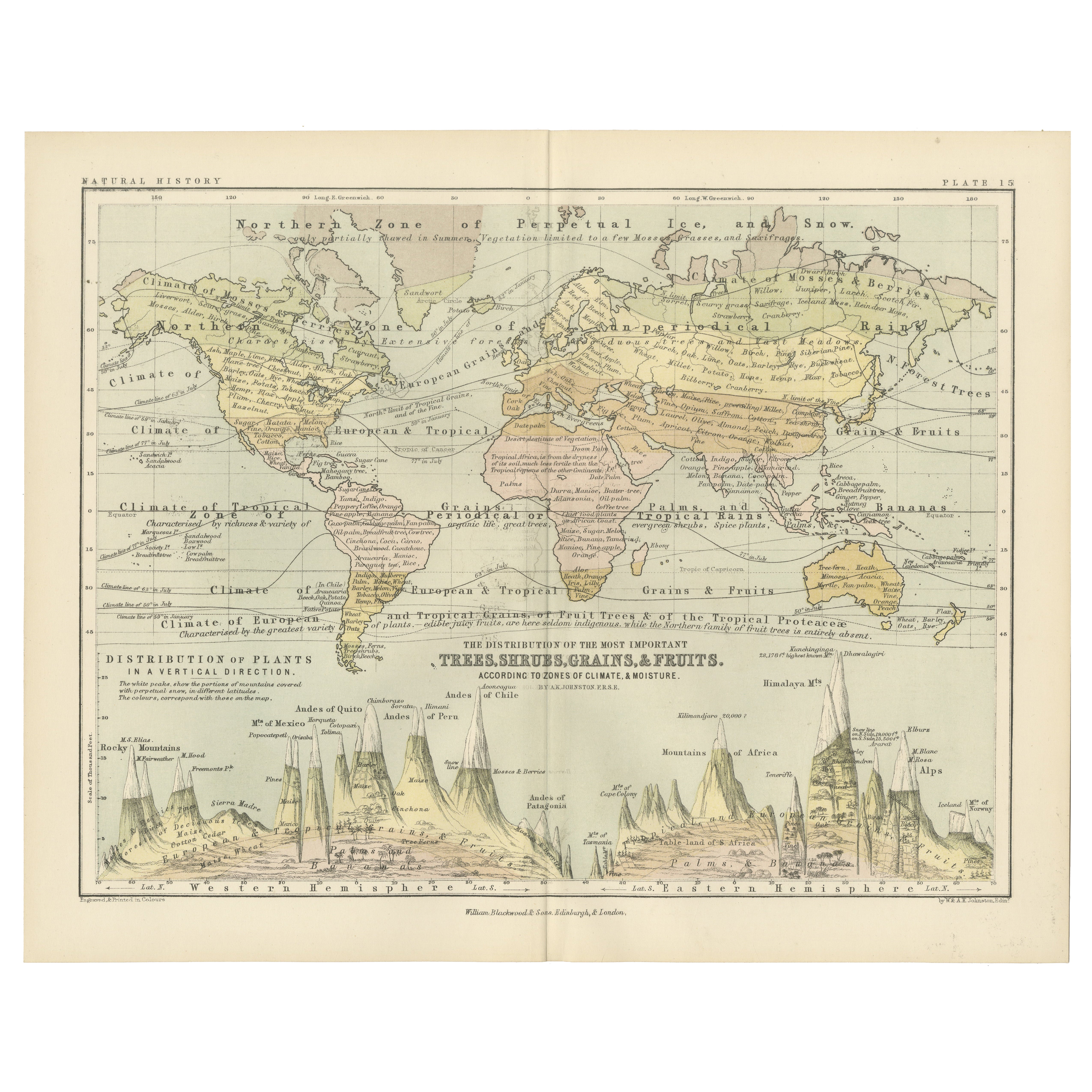
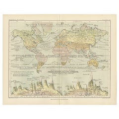
Botanical Map by A.K. Johnston – Global Plant Distribution Chart 1852
Botanical Map by A.K. Johnston – Global Plant Distribution Chart 1852
This remarkable antique chart titled "The Distribution of the Most Important Trees, Shrubs, Grains, & Fruits Ac...
Catégorie
Antiquités, Milieu du XIXe siècle, Écossais, Estampes
Matériaux
Papier
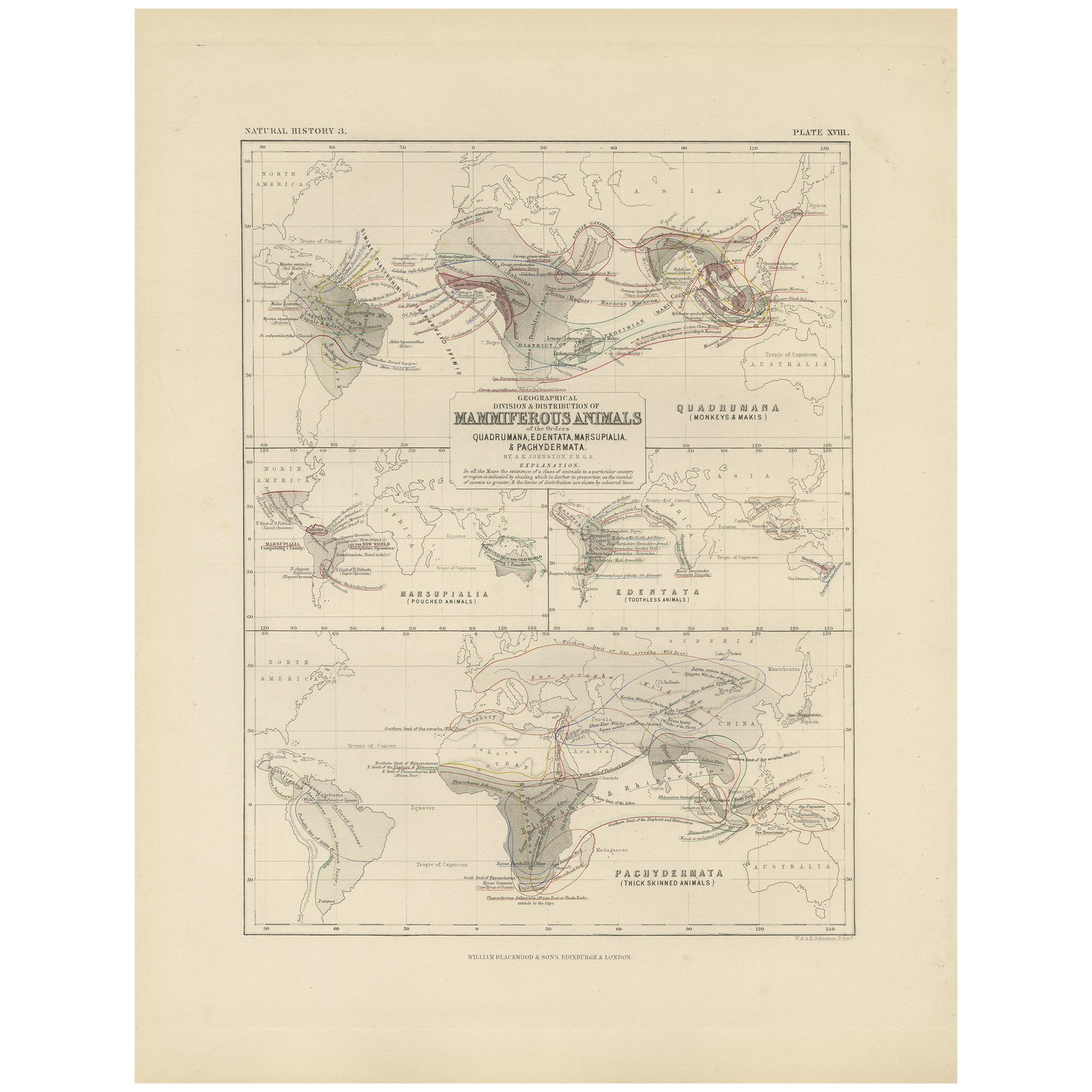
Carte ancienne montrant la division et la distribution des mammouths par Johnston
1850
Carte ancienne intitulée "Geographical division and distribution of mammiferous animals of the orders quadrumana, edentata, marsupialia & pachydermata". Carte ancienne originale mont...
Catégorie
Antiquités, Milieu du XIXe siècle, Cartes
Matériaux
Papier
130 € Prix de vente
35 % de remise
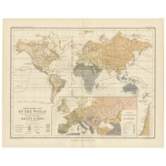
Ethnographic Map of the World by A.K. Johnston – Races of Man Chart 1852
Ethnographic Map of the World by A.K. Johnston – Races of Man Chart 1852
This antique map titled "Ethnographic Map of the World Showing the Present Distribution of the Leading Races...
Catégorie
Antiquités, Milieu du XIXe siècle, Écossais, Estampes
Matériaux
Papier
Ancienne carte zoologique et botanique du monde - Carte décorative, 1884
Anciennes cartes zoologiques et botaniques du monde - Black's Atlas, 1884
Cette double planche de la New and Revised Edition of Black's General Atlas of the World, publiée à Édimbou...
Catégorie
Antiquités, années 1880, Écossais, Cartes
Matériaux
Papier
Suggestions
Carte du monde originale et ancienne par Dower, vers 1835
Belle carte du monde
Dessiné et gravé par J.Dower
Publié par Orr & Smith. C.1835
Non encadré.
Expédition gratuite
Catégorie
Antiquités, années 1830, Anglais, Cartes
Matériaux
Papier

Planisphere originale illustrée - Carte du monde - Géographie, 1864
Plongez dans l'épopée du passé avec le Planisphère historique illustré de 1864 par Charpentier ! 🗺️ Ce trésor cartographique vous transporte dans les méandres de l'histoire, avec de...
Catégorie
années 1860, Estampes et éditions
Matériaux
Lin, Papier, Lithographie

Carte originale et ancienne du monde par Thomas Clerk, 1817
Grande carte des hémisphères oriental et occidental
Sur 2 feuilles
Gravure sur cuivre
Dessiné et gravé par Thomas Clerk, Édimbourg.
Publié par Mackenzie et Dent, 1817
...
Catégorie
Antiquités, années 1810, Anglais, Cartes
Matériaux
Papier

Carte de l
Empire britannique ancien - Carte ancienne de Karl Spruner - 1760 environ
Par Karl Spruner von Merz
Old British Empire Map est une œuvre d'art réalisée vers 1760 par Karl Spruner.
Épreuve originale colorée à la main.
Bon état sauf un jaunissement du papier le long de la marge, et...
Catégorie
années 1760, Moderne, Estampes - Figuratif
Matériaux
Eau-forte

Grande carte ancienne originale du monde, Fullarton, vers 1870
Superbe carte du monde. Montrer les deux hémisphères
Extrait du célèbre Royal Illustrated Atlas
Lithographie. Couleur originale.
Publié par Fullarton, Edinburgh, C.1870.
Sans ca...
Catégorie
Antiquités, années 1870, Écossais, Cartes
Matériaux
Papier

Carte ancienne originale de l
hémisphère oriental par Dower, vers 1835
Belle carte de l'hémisphère oriental
Dessiné et gravé par J.Dower
Publié par Orr & Smith. C.1835
Non encadré.
Expédition gratuite
Catégorie
Antiquités, années 1830, Anglais, Cartes
Matériaux
Papier
