Articles similaires à Geological Map of Africa by A.K. Johnston – Mountains and Valleys 1852


Vous voulez plus d
images ou de vidéos ?
Demander au vendeur plus d
images ou de vidéos
1 sur 10
Geological Map of Africa by A.K. Johnston – Mountains and Valleys 1852
260 €par article|TVA incluse
Quantité
À propos de cet article
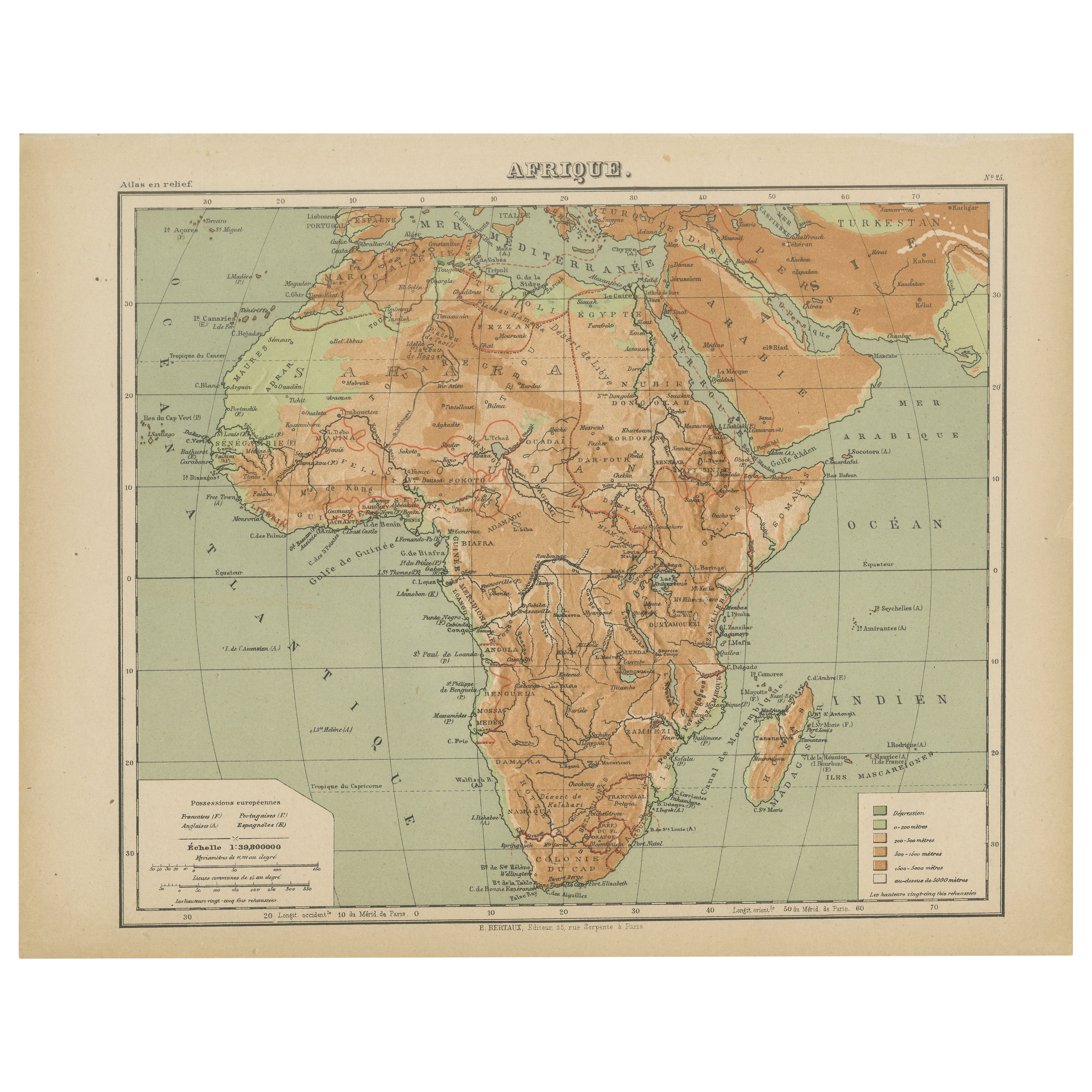
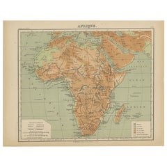
Geological Map of Africa by A.K. Johnston – Mountains and Valleys 1852
This antique map titled "The Mountains, Table Lands, Plains
Valleys of Africa" was produced by the distinguished Scottish cartographer Alexander Keith Johnston and published in 1852 by William Blackwood
Sons, Edinburgh and London. Issued as Plate 7 in Johnston’s seminal work *The Physical Atlas of Natural Phenomena*, it represents one of the earliest and most influential attempts to visualize Africa’s topography through scientific cartography.
This map presents a detailed physical overview of the African continent, using subtle coloration and shading to depict mountain ranges, elevated tablelands, deserts, and low-lying river basins. Unlike political maps of the period, it forgoes country borders in favor of a focus on natural geography. Earth-toned shades indicate elevation—yellow and tan for deserts and plains, green for coastal lowlands, and brown for highlands and mountain systems.
Prominent physical features such as the Atlas Mountains, Ethiopian Highlands, the Mountains of the Moon, Table Mountain, the Sahara Desert, and the Great Rift Valley are clearly labeled. River systems including the Nile, Niger, Congo, and Zambezi are also traced with scientific accuracy. This map offers an insightful view of Africa's geologic and climatic structure before many interior regions had been fully charted by European explorers.
A.K. Johnston (1804–1871), who served as Geographer in Ordinary to Queen Victoria in Scotland, was a pioneer in thematic cartography. His *Physical Atlas* was the first of its kind to translate complex natural data into visual form, combining scientific precision with artistic presentation. This map stands out not only for its geographical value but for its restrained beauty and clarity—qualities that made Johnston’s atlases widely respected by scientists, educators, and collectors alike.
This print is a valuable addition to collections focused on African geography, scientific history, or antique educational material, and it remains aesthetically appealing for decorative use.
Condition and framing tips:
Very good condition with light age toning and faint edge wear. The engraved detail is sharp, and the original hand coloring remains clean and vivid. Frame in black or dark oak with a cream or soft sand-colored mat to highlight the warm earth tones and emphasize the elegant cartographic lines. Suitable for a library, office, or academic space.
- Dimensions:Hauteur : 27,4 cm (10,79 po)Largeur : 34,5 cm (13,59 po)Profondeur : 0,2 mm (0,01 po)
- Matériaux et techniques:
- Lieu d origine:
- Période:
- Date de fabrication:1852
- État:Very good condition. Light overall toning near the margins. The paper remains strong and well-preserved. Folding line as issued.
- Adresse du vendeur:Langweer, NL
- Numéro de référence:Vendeur : BG-13207-71stDibs : LU3054345386642
À propos du vendeur
5,0
Vendeur reconnu
Ces vendeurs prestigieux sont des leaders du secteur. Ils représentent le summum en matière de qualité et de design.
Vendeur Platine
Vendeurs premium dont la note est supérieure à 4,7 et le délai de réponse de 24 heures maximum
Établi en 2009
Vendeur 1stDibs depuis 2017
2 809 ventes sur 1stDibs
Temps de réponse habituel : 1 heure
- ExpéditionRecherche du devis...Expédition depuis : Langweer, Pays-Bas
- Politique des retours
Certaines parties de cette page ont été traduites automatiquement. 1stDibs ne garantit pas l
exactitude des traductions. L
anglais est la langue par défaut de ce site web.
Plus d articles de ce vendeur
Tout afficherCarte d
Afrique avec insertions d
Egypte et d
Afrique du Sud - Nieuwe Hand-Atlas, 1876
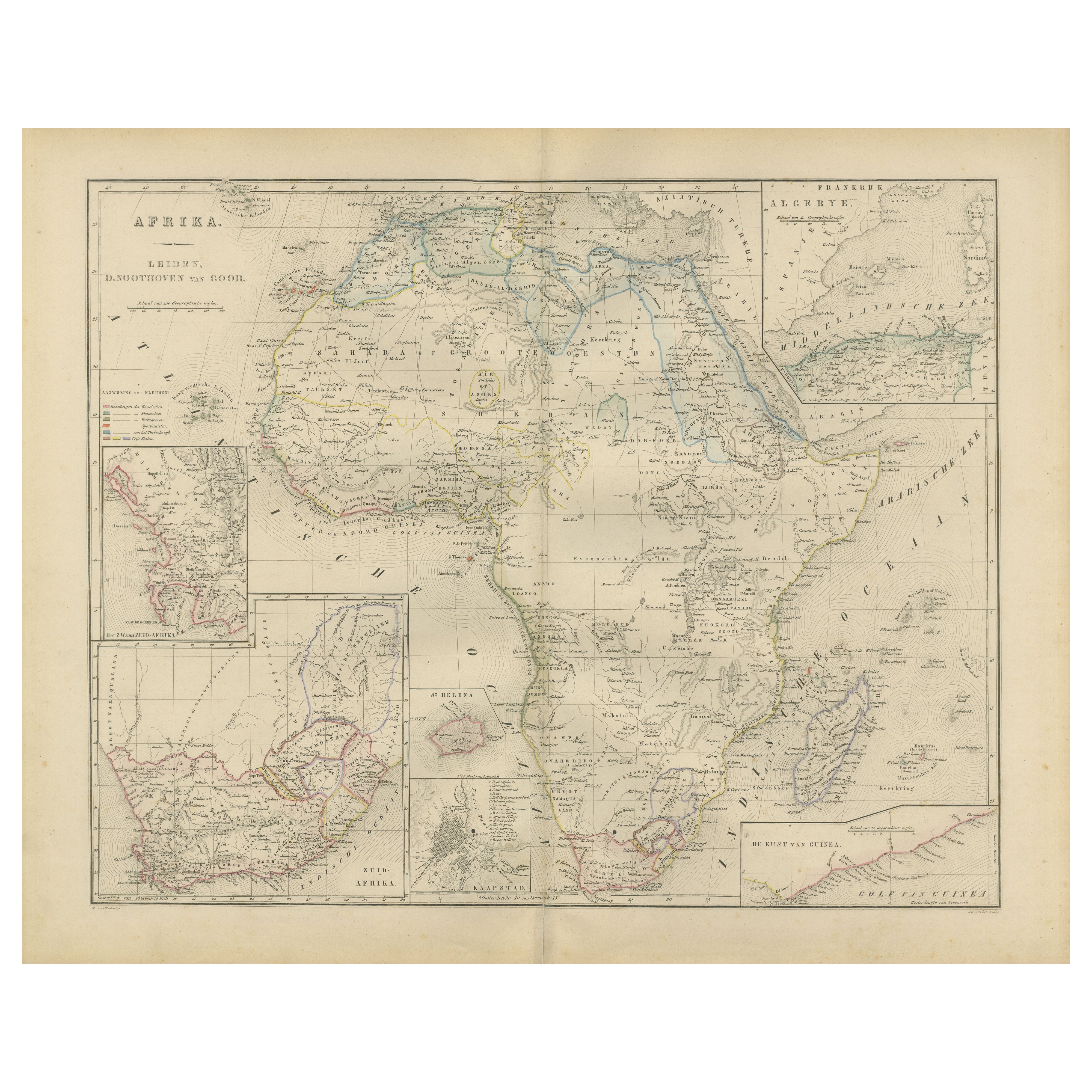
Carte d'Afrique avec insertions d'Egypte et d'Afrique du Sud - Nieuwe Hand-Atlas, 1876
Cette carte du XIXe siècle intitulée "Afrika", publiée en 1876 dans le Nieuwe Hand-Atlas der A...
Catégorie
Antiquités, années 1870, Néerlandais, Cartes
Matériaux
Papier
Atlas en relief de l
Afrique par Hachette - Antique c.1883 French Map
Carte ancienne de l'Afrique - Carte Atlas en relief par Hachette, circa 1880
Description :
Il s'agit d'une jolie carte ancienne intitulée "Afrique", publiée par Hachette à Paris ver...
Catégorie
Antiquités, Fin du XIXe siècle, Cartes
Matériaux
Papier
Carte ancienne de l
Afrique, mettant en évidence les divisions coloniales, les caractéristiques géographiques 1903
Titre : Carte ancienne de l'Afrique, 1903, mettant en évidence les divisions coloniales et les caractéristiques géographiques.
Description : Cette carte ancienne, intitulée " Afriqu...
Catégorie
Début du 20ème siècle, Cartes
Matériaux
Papier

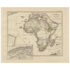
Carte ancienne en couleurs de l
Afrique avec encart sur l
Algérie - Stieler Atlas 1858
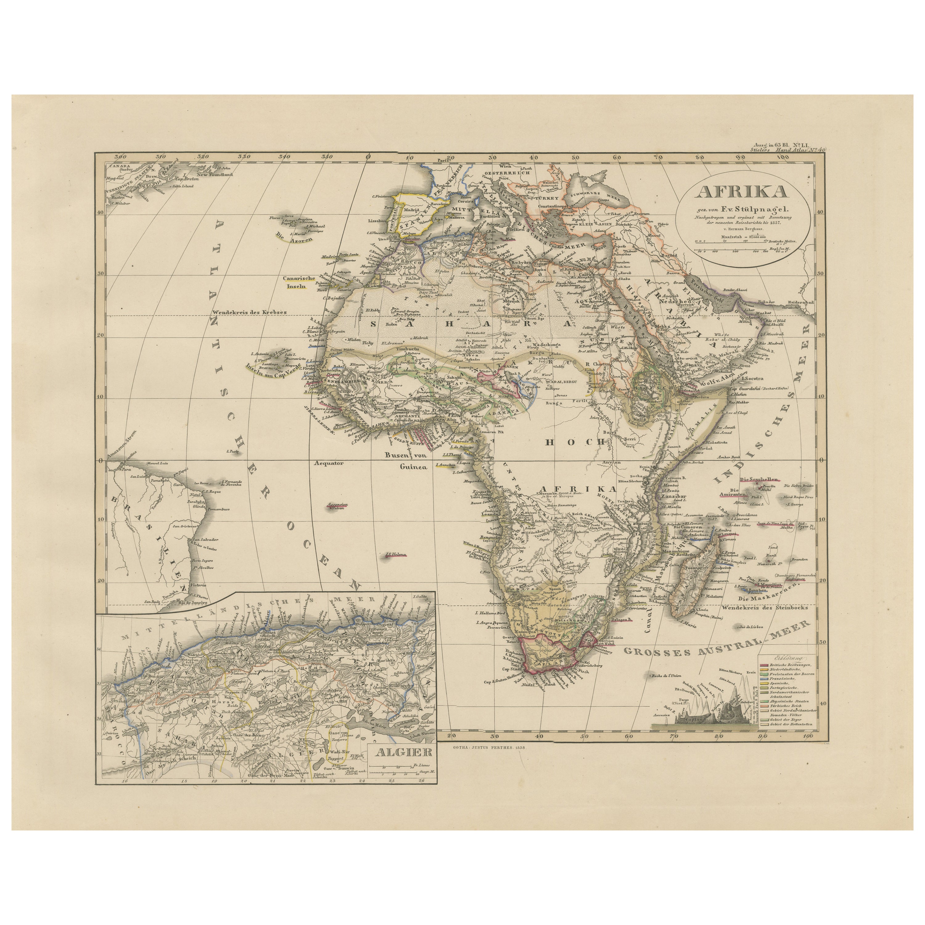
Carte ancienne de l'Afrique avec encart sur l'Algérie - Stieler Atlas 1858
Cette carte ancienne de l'Afrique, gravée par F. von Stülpnagel et publiée par Justus Perthes en 1858, est...
Catégorie
Antiquités, Milieu du XIXe siècle, Allemand, Cartes
Matériaux
Papier
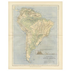
Geological Map of South America by A.K. Johnston – Mountains and Valleys 1852
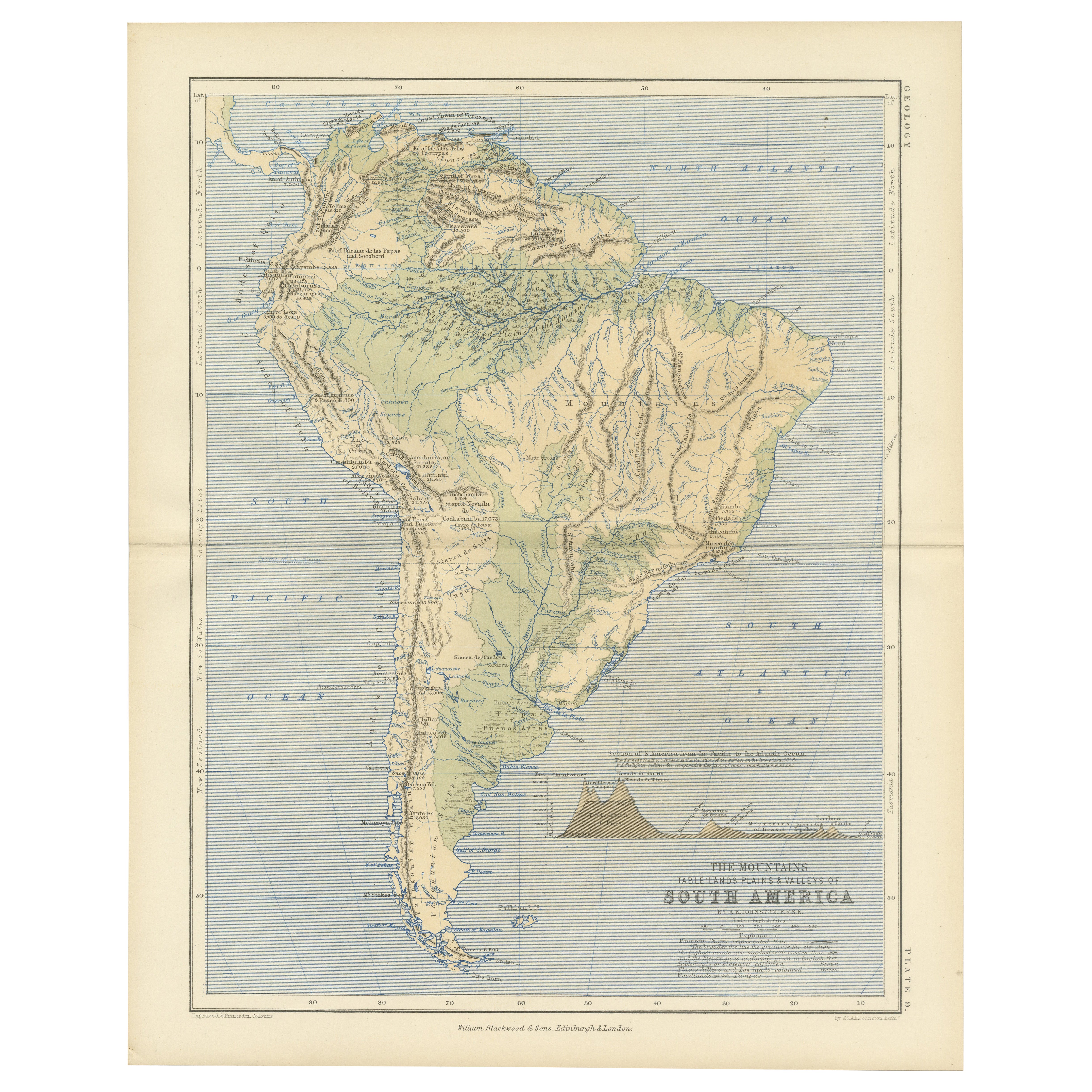
Geological Map of South America by A.K. Johnston – Mountains and Valleys 1852
This antique map titled "The Mountains, Table Lands, Plains & Valleys of South America" was produced by...
Catégorie
Antiquités, Milieu du XIXe siècle, Écossais, Estampes
Matériaux
Papier
Carte ancienne de l
Afrique par Lapie:: 1842
Carte ancienne intitulée "Carte d'Afrique". Carte de l'Afrique. Cette carte provient de l'"Atlas universel de géographie ancienne et moderne (...)" de Pierre M. Lapie et Alexandre E....
Catégorie
Antiquités, Milieu du XIXe siècle, Cartes
Matériaux
Papier

Suggestions
Carte ancienne originale de l
Afrique par Dower, vers 1835
Belle carte de l'Afrique
Dessiné et gravé par J.Dower
Publié par Orr & Smith. C.1835
Non encadré.
Expédition gratuite
Catégorie
Antiquités, années 1830, Anglais, Cartes
Matériaux
Papier

Grande carte ancienne originale d
Afrique. C.1900
Fabuleuse carte de l'Afrique
Couleur originale.
Gravé et imprimé par la George F. Crams Company, Indianapolis.
Publié, C.C.C..
Non encadré.
Livraison gratuite.
Catégorie
Antiquités, années 1890, Américain, Cartes
Matériaux
Papier

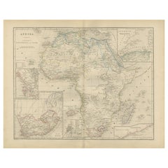
Afrique. Part One. Carte vintage Atlas du XXe siècle
L'Atlas du siècle. Afrique. Partie nord-est
Carte originale ancienne, 1903.
Carte en médaillon du "Delta du Nil et du canal de Suez".
Pli central tel que publié. Le nom et le numér...
Catégorie
Début du 20ème siècle, Victorien, Plus d Estampes
Matériaux
Lithographie

Afrique. Partie sud. Carte vintage Atlas du XXe siècle
L'Atlas du siècle. Afrique. Partie sud
Carte originale ancienne, 1903.
Cartes en médaillon de "Cape Town", "Johannesburg" et "Ladysmith".
Pli central tel que publié. Le nom et le n...
Catégorie
Début du 20ème siècle, Victorien, Plus d Estampes
Matériaux
Lithographie

Afrique. Central. Carte vintage Atlas du XXe siècle
L'Atlas du siècle. Afrique. Central'
Carte en médaillon de "Madagascar".
Carte originale ancienne, 1903.
Pli central tel que publié. Le nom et le numéro de la carte sont imprimés s...
Catégorie
Début du 20ème siècle, Victorien, Plus d Estampes
Matériaux
Lithographie

Carte de l
Afrique - Gravure originale de C. Brue - 1820
Carte d'Afrique est une gravure originale réalisée par C.Brue en 1820.
L'impression provient de la série "Atlas Universal" PL. 31.
L'état de conservation de l'œuvre est bon, à l'ex...
Catégorie
années 1820, Moderne, Estampes - Figuratif
Matériaux
Eau-forte
