Articles similaires à Geological Map of North America by A.K. Johnston – Mountains and Valleys 1852


Vous voulez plus d
images ou de vidéos ?
Demander au vendeur plus d
images ou de vidéos
1 sur 12
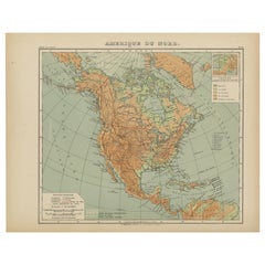
Geological Map of North America by A.K. Johnston – Mountains and Valleys 1852
260 €par article|TVA incluse
Quantité
À propos de cet article
Geological Map of North America by A.K. Johnston – Mountains and Valleys 1852
This finely detailed and beautifully shaded antique map titled "The Mountains, Table Lands, Plains
Valleys of North America" was created by the noted Scottish geographer Alexander Keith Johnston and published in 1852 by William Blackwood
Sons in Edinburgh and London. It was issued as Plate 8 in Johnston’s groundbreaking *Physical Atlas of Natural Phenomena*, one of the earliest and most influential works of thematic cartography in the 19th century.
The map presents the topographic structure of the North American continent, emphasizing physical geography over political borders. Using a delicate yet effective palette of hand-applied color, it distinguishes between mountainous regions, plateaus, plains, and river valleys. Green areas denote lowlands and river basins, while tan and brown areas indicate elevated terrain, such as mountain ranges and high plateaus.
Key geographical features are precisely labeled, including the Rocky Mountains, Appalachian Mountains, Sierra Nevada, Great Basin, Canadian Shield, and Mississippi River Valley. The map covers all of North America, including Canada, the United States, Mexico, Central America, the Caribbean, and Greenland, as well as the Arctic archipelagos. Major tablelands such as those of Mexico and the Colorado Plateau are also clearly outlined, demonstrating the complexity of North America's geological structure.
What sets this map apart is its educational clarity and scientific intent. Johnston’s work was intended to inform and enlighten readers about the structure of the natural world, making this a valuable piece not just for collectors of antique maps but also for educators, environmental historians, and interior designers seeking historically meaningful artwork.
Alexander Keith Johnston (1804–1871) was a pioneering figure in British cartography. As Geographer in Ordinary to Queen Victoria for Scotland, he advanced the visual communication of scientific data through maps. His *Physical Atlas* remains a landmark publication in the history of science and cartography.
Condition and framing tips:
Very good condition with light age toning, original centerfold, and faint foxing at edges. Printed area clean and well-preserved. Frame in dark wood or black with a soft ivory or sage green mat to enhance the earthy palette and highlight the map's elegant detailing. Perfect for libraries, offices, or natural history-themed interiors.
- Dimensions:Hauteur : 34,5 cm (13,59 po)Largeur : 27,4 cm (10,79 po)Profondeur : 0,2 mm (0,01 po)
- Matériaux et techniques:
- Lieu d origine:
- Période:
- Date de fabrication:1852
- État:Very good condition. Light overall toning near the margins. The paper remains strong and well-preserved. Folding line as issued.
- Adresse du vendeur:Langweer, NL
- Numéro de référence:Vendeur : BG-13207-81stDibs : LU3054345386722
À propos du vendeur
5,0
Vendeur reconnu
Ces vendeurs prestigieux sont des leaders du secteur. Ils représentent le summum en matière de qualité et de design.
Vendeur Platine
Vendeurs premium dont la note est supérieure à 4,7 et le délai de réponse de 24 heures maximum
Établi en 2009
Vendeur 1stDibs depuis 2017
2 810 ventes sur 1stDibs
Temps de réponse habituel : <1 heure
- ExpéditionRecherche du devis...Expédition depuis : Langweer, Pays-Bas
- Politique des retours
Certaines parties de cette page ont été traduites automatiquement. 1stDibs ne garantit pas l
exactitude des traductions. L
anglais est la langue par défaut de ce site web.
Plus d articles de ce vendeur
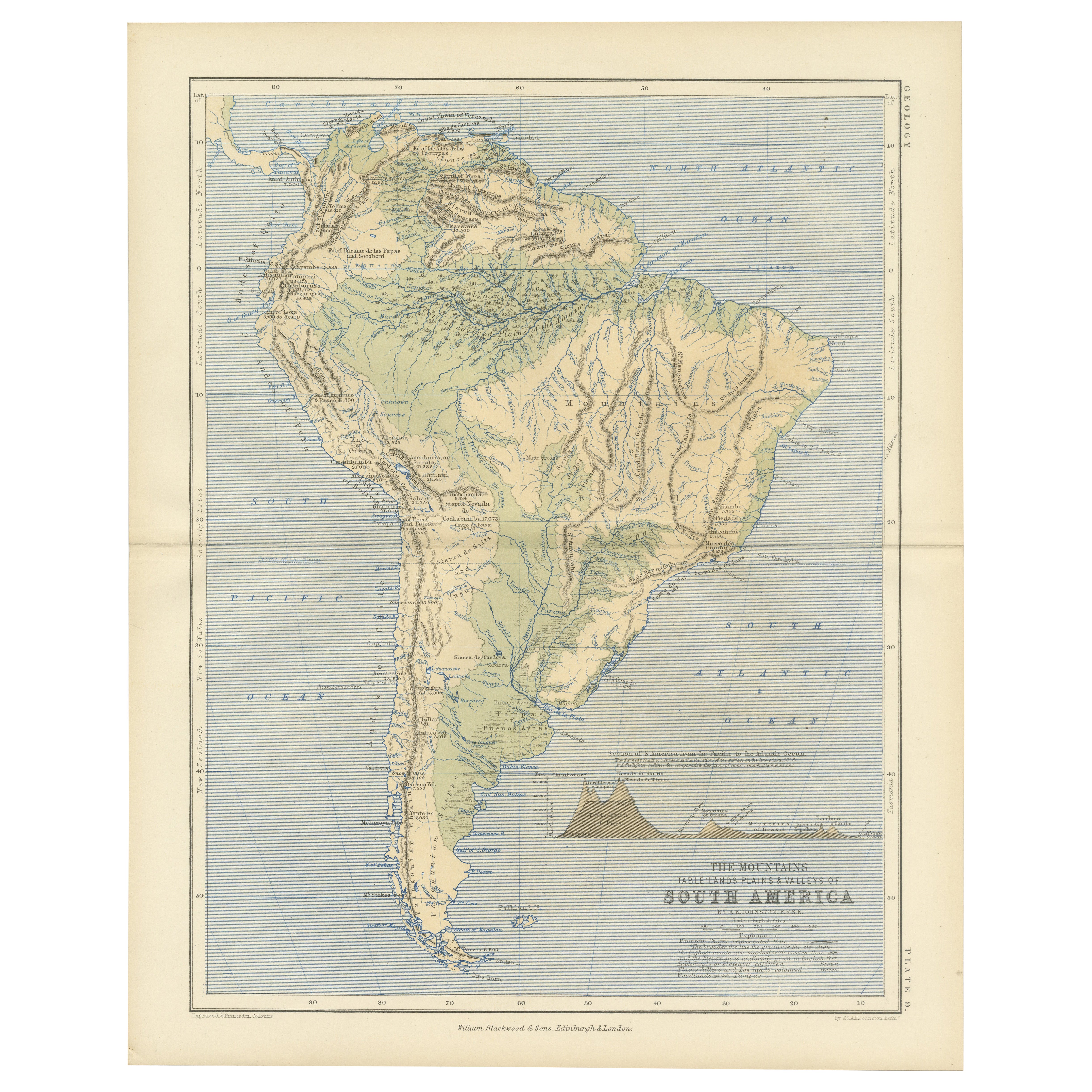
Tout afficherGeological Map of South America by A.K. Johnston – Mountains and Valleys 1852
Geological Map of South America by A.K. Johnston – Mountains and Valleys 1852
This antique map titled "The Mountains, Table Lands, Plains & Valleys of South America" was produced by...
Catégorie
Antiquités, Milieu du XIXe siècle, Écossais, Estampes
Matériaux
Papier
Carte ancienne de l
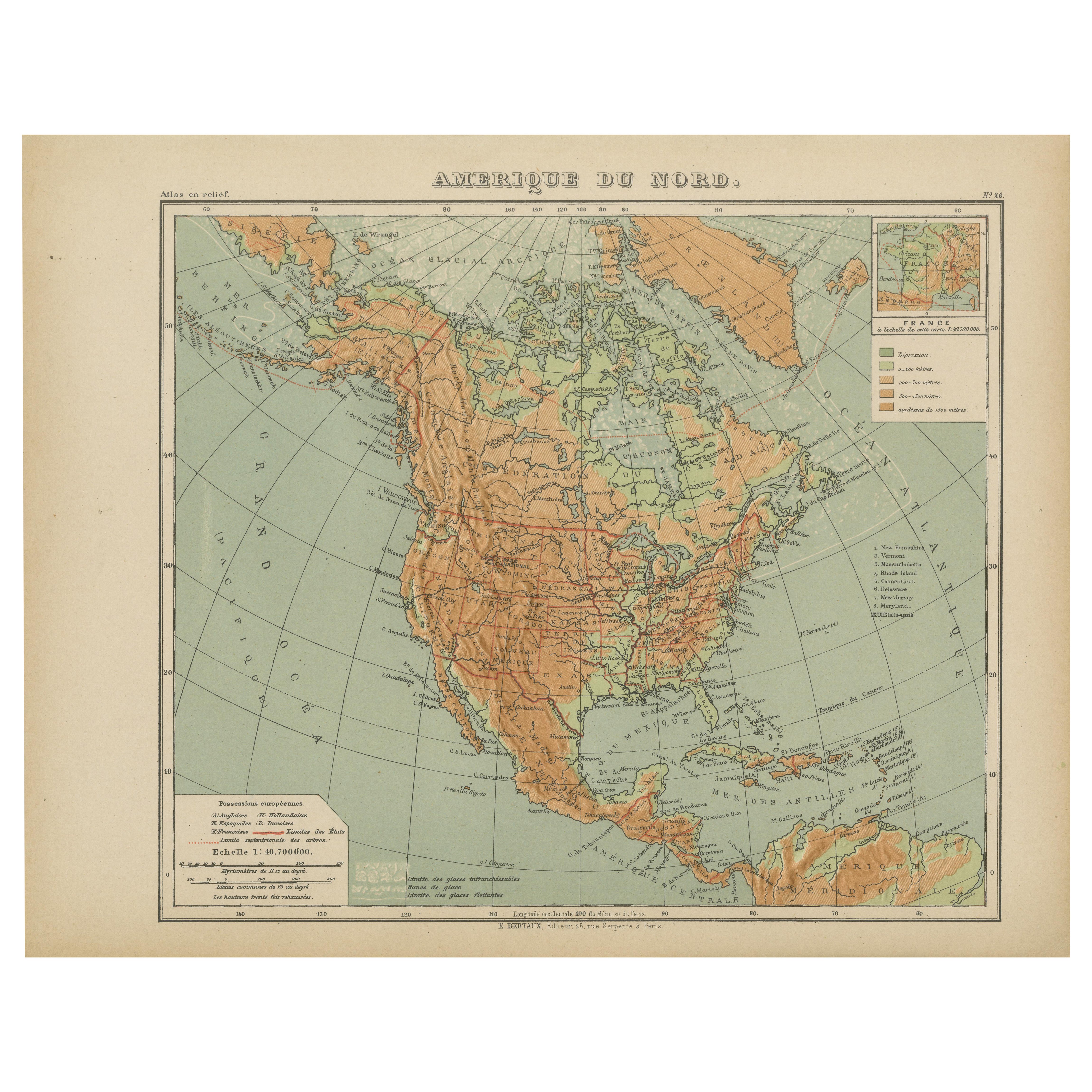
Amérique du Nord - Carte en relief physique par Hachette c.1883
Carte ancienne de l'Amérique du Nord - Carte en relief physique par Hachette c.1883
Description :
Cette carte ancienne intitulée "Amérique du Nord" a été publiée vers 1883 par E. Ha...
Catégorie
Antiquités, Fin du XIXe siècle, Français, Cartes
Matériaux
Papier
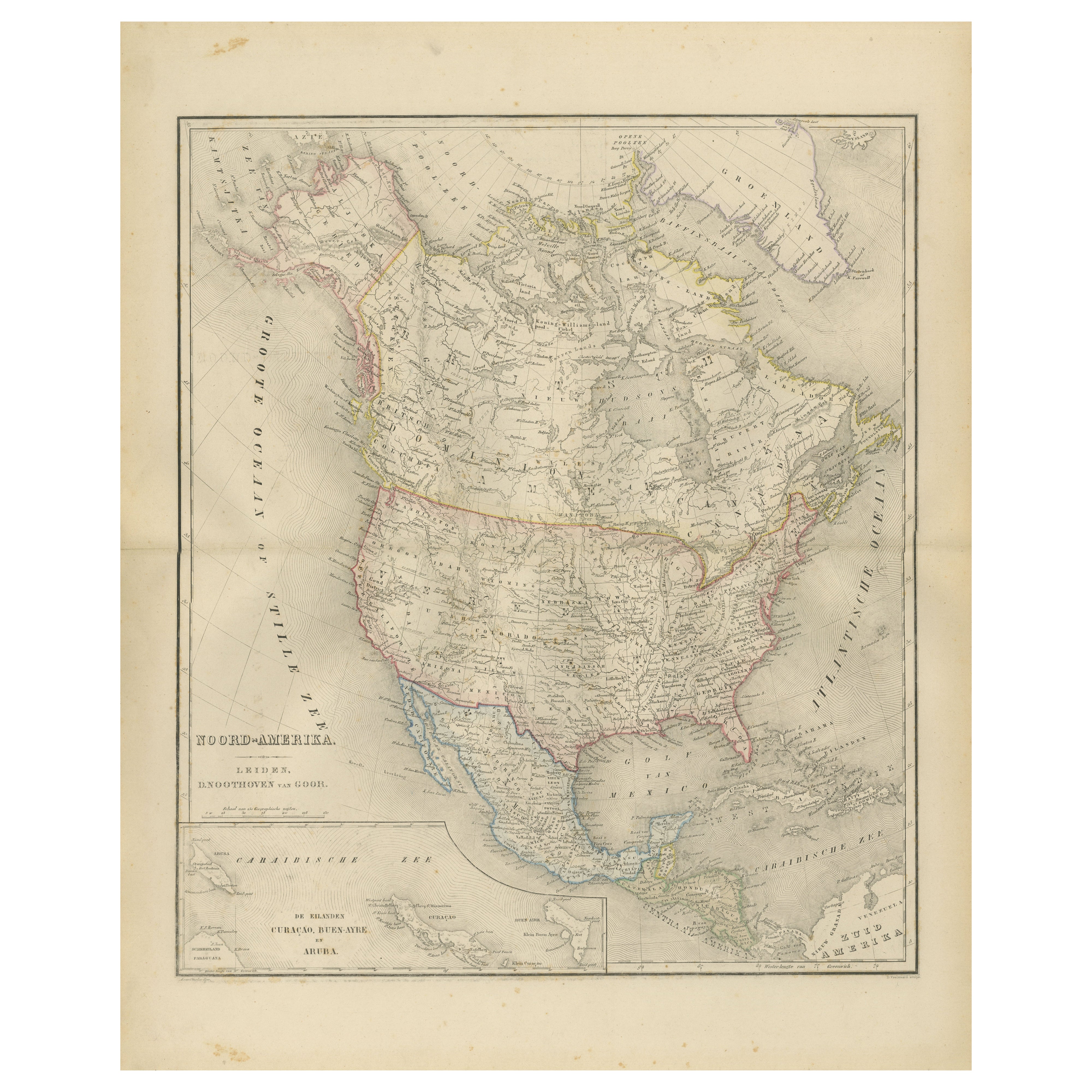
Carte de l
Amérique du Nord avec les Etats-Unis, le Canada et le Mexique - Nieuwe Hand-Atlas, 1876
Carte de l'Amérique du Nord avec les Etats-Unis, le Canada et le Mexique - Nieuwe Hand-Atlas, 1876
Cette carte finement gravée du XIXe siècle de la "Noord-Amerika", publiée en 1876 ...
Catégorie
Antiquités, années 1870, Néerlandais, Cartes
Matériaux
Papier
Carte ancienne d
Amérique du Nord par A
C. Black, 1870
Carte ancienne intitulée "Amérique du Nord". Carte ancienne originale de l'Amérique du Nord. Cette carte provient du "Black's General Atlas of The World". Publié par A & C. Black, 1870.
Catégorie
Antiquités, Fin du XIXe siècle, Cartes
Matériaux
Papier

220 € Prix de vente
20 % de remise
Carte ancienne d
Amérique du Nord par Johnston, 1882
Par Alexander Keith Johnston
Carte ancienne intitulée "Amérique du Nord".
Ancienne carte de l'Amérique du Nord. Cette carte provient de "The Royal Atlas of Modern Geography, Exhibiting, in a Series of Entirely...
Catégorie
Antiquités, XIXe siècle, Cartes
Matériaux
Papier

Geological Map of Africa by A.K. Johnston – Mountains and Valleys 1852
Geological Map of Africa by A.K. Johnston – Mountains and Valleys 1852
This antique map titled "The Mountains, Table Lands, Plains & Valleys of Africa" was produced by the distingui...
Catégorie
Antiquités, Milieu du XIXe siècle, Écossais, Estampes
Matériaux
Papier
Suggestions
Amérique du Nord. Carte vintage Atlas du XXe siècle
L'Atlas du siècle. Amérique du Nord
Carte originale ancienne, 1903.
Pli central tel que publié. Le nom et le numéro de la carte sont imprimés sur les coins arrière.
Feuille 40cm pa...
Catégorie
Début du 20ème siècle, Victorien, Plus d Estampes
Matériaux
Lithographie

Carte ancienne originale de l
Amérique du Nord par Dower, vers 1835
Belle carte de l'Amérique du Nord
Dessiné et gravé par J.Dower
Publié par Orr & Smith. C.1835
Non encadré.
Expédition gratuite
Catégorie
Antiquités, années 1830, Anglais, Cartes
Matériaux
Papier

Grande carte originale vintage de l
Amérique du Nord, circa 1920
Grande carte de l'Amérique du Nord
Couleur originale. Bon état
Publié par Alexander Gross
Non encadré.
Catégorie
Vintage, années 1920, Anglais, Édouardien, Cartes
Matériaux
Papier

Carte d
Amérique du Nord de 1864, carte ancienne colorée à la main, par Adolphe Hippolyte Dufour
La carte proposée est une carte de l'Amérique du Nord intitulée Amerique du Nord, datant de 1864. Cette carte murale rare, publiée séparément, a été réalisée par Adolphe Hippolyte Du...
Catégorie
Antiquités, années 1860, Français, Cartes
Matériaux
Papier

Carte ancienne originale des Etats-Unis d
Amérique par Dower, vers 1835
Belle carte des Etats-Unis
Dessiné et gravé par J.Dower
Publié par Orr & Smith. C.1835
Non encadré.
Expédition gratuite
Catégorie
Antiquités, années 1830, Anglais, Cartes
Matériaux
Papier

Grande carte d
Amérique du Nord et de territoires de 1848
Carte encadrée de 1848 de S. Augustus and Mitchell, Philadelphie, PA. Carte de l'Amérique du Nord et de ses territoires.
Les États-Unis, le Canada (territoire britannique) et les te...
Catégorie
Antiquités, années 1840, Américain, Classique américain, Cartes
Matériaux
Verre, Bois, Papier
