Articles similaires à Religious Belief Map by A.K. Johnston – Moral and Statistical Chart 1852


Vous voulez plus d
images ou de vidéos ?
Demander au vendeur plus d
images ou de vidéos
1 sur 11
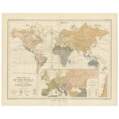
Religious Belief Map by A.K. Johnston – Moral and Statistical Chart 1852
260 €par article|TVA incluse
Quantité
À propos de cet article
Religious Belief Map by A.K. Johnston – Moral and Statistical Chart 1852
This antique chart titled "Moral
Statistical Chart Showing the Distribution of Man According to Prevailing Forms of Religious Belief
the Proportionate Number of Each Creed in the Principal States of the Globe" was created by Alexander Keith Johnston and published in 1852 by William Blackwood
Sons in Edinburgh and London. Issued as Plate 18 in Johnston’s *Physical Atlas of Natural Phenomena*, this map is a rare and historically significant early attempt to visualize global religious demographics.
The world is color-coded to reflect the dominant religions in various regions, including Christianity (with Roman Catholic, Greek Orthodox, and Protestant branches distinguished), Islam (Sunni and Shiite), Buddhism, Brahmanism (Hinduism), Judaism, and areas broadly labeled as "Heathen" or "Other Faiths," in accordance with 19th-century terminology. The color-coded legend to the lower right includes estimated numbers of adherents for each group, offering a numerical context to the geographic distribution.
Each country or empire is labeled with estimates of its religious composition and population size, from the British Isles and Ottoman Empire to China, Russia, India, and the Americas. The chart reflects not only religious spread, but also the political-religious affiliations of empires and colonial powers during the mid-19th century.
At the bottom of the chart is a diagram titled “Progress of Education,” using bar graphs to compare levels of literacy and schooling across nations—an early example of combining moral and statistical inquiry through cartography. Countries such as Prussia, Scotland, and Saxony rank highest in this education index, while others show much lower rates of public instruction, as interpreted from available data at the time.
Alexander Keith Johnston (1804–1871), Geographer in Ordinary to Queen Victoria in Scotland, was a pioneer in thematic and scientific cartography. His *Physical Atlas* was one of the first atlases to integrate human, environmental, and physical data into visually compelling and educational maps.
This plate is of particular interest to collectors of religious history, antique data visualization, and 19th-century worldviews. It reflects the empirical spirit of the age, while also serving as a historical document of cultural perspectives from a European scientific lens.
Condition and framing tips:
Very good antique condition with some mild age toning and a clean printed surface. Original centerfold as issued. Frame in a dark or neutral wood with a cream or parchment mat to complement the subtle pastel palette and enhance legibility. Ideal for display in a study, library, or historical institution.
- Dimensions:Hauteur : 27,4 cm (10,79 po)Largeur : 34,5 cm (13,59 po)Profondeur : 0,2 mm (0,01 po)
- Matériaux et techniques:
- Lieu d origine:
- Période:
- Date de fabrication:1852
- État:Very good condition. Light overall toning near the margins. The paper remains strong and well-preserved. Folding line as issued.
- Adresse du vendeur:Langweer, NL
- Numéro de référence:Vendeur : BG-13207-181stDibs : LU3054345393582
À propos du vendeur
5,0
Vendeur reconnu
Ces vendeurs prestigieux sont des leaders du secteur. Ils représentent le summum en matière de qualité et de design.
Vendeur Platine
Vendeurs premium dont la note est supérieure à 4,7 et le délai de réponse de 24 heures maximum
Établi en 2009
Vendeur 1stDibs depuis 2017
2 803 ventes sur 1stDibs
Temps de réponse habituel : <1 heure
- ExpéditionRecherche du devis...Expédition depuis : Langweer, Pays-Bas
- Politique des retours
Certaines parties de cette page ont été traduites automatiquement. 1stDibs ne garantit pas l
exactitude des traductions. L
anglais est la langue par défaut de ce site web.
Plus d articles de ce vendeur
Tout afficherCarte ancienne montrant les religions du monde entier par Johnston
1854
Carte ancienne intitulée "Moral & Statistical Chart showing the Geographical Distribution of Man According to Religious Belief". Rare carte thématique de grande taille sur la réparti...
Catégorie
Antiquités, Milieu du XIXe siècle, Cartes
Matériaux
Papier

780 € Prix de vente
35 % de remise
Ethnographic Map of the World by A.K. Johnston – Races of Man Chart 1852
Ethnographic Map of the World by A.K. Johnston – Races of Man Chart 1852
This antique map titled "Ethnographic Map of the World Showing the Present Distribution of the Leading Races...
Catégorie
Antiquités, Milieu du XIXe siècle, Écossais, Estampes
Matériaux
Papier
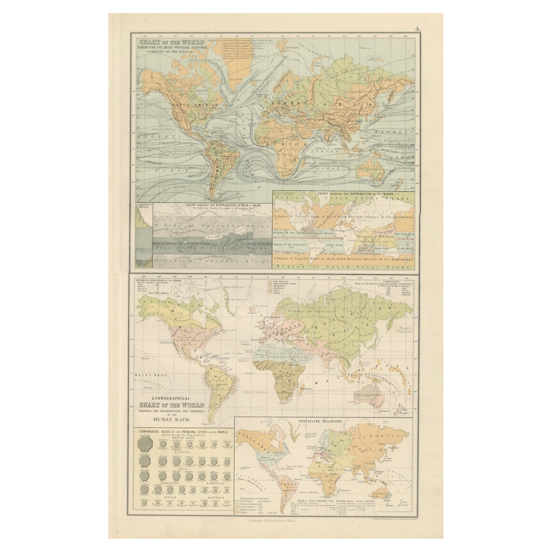
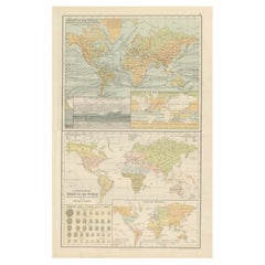
Cartes anciennes du monde - Caractéristiques physiques et carte ethnographique, 1884
Cartes anciennes du monde - Caractéristiques physiques et carte ethnographique, 1884
Description :
Cette fascinante double planche de la New and Revised Edition of Black's General A...
Catégorie
Antiquités, années 1880, Écossais, Cartes
Matériaux
Papier
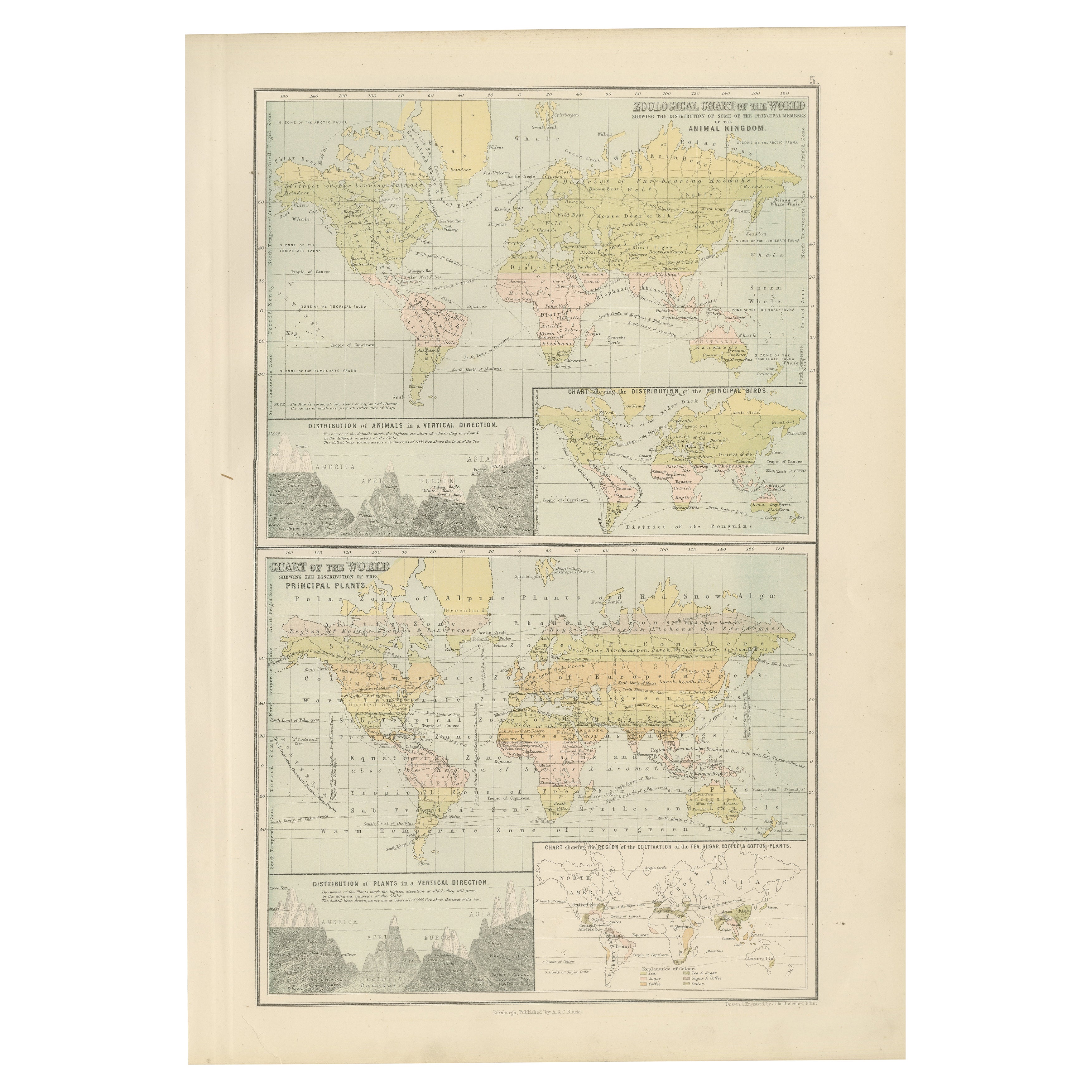
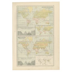
Ancienne carte zoologique et botanique du monde - Carte décorative, 1884
Anciennes cartes zoologiques et botaniques du monde - Black's Atlas, 1884
Cette double planche de la New and Revised Edition of Black's General Atlas of the World, publiée à Édimbou...
Catégorie
Antiquités, années 1880, Écossais, Cartes
Matériaux
Papier
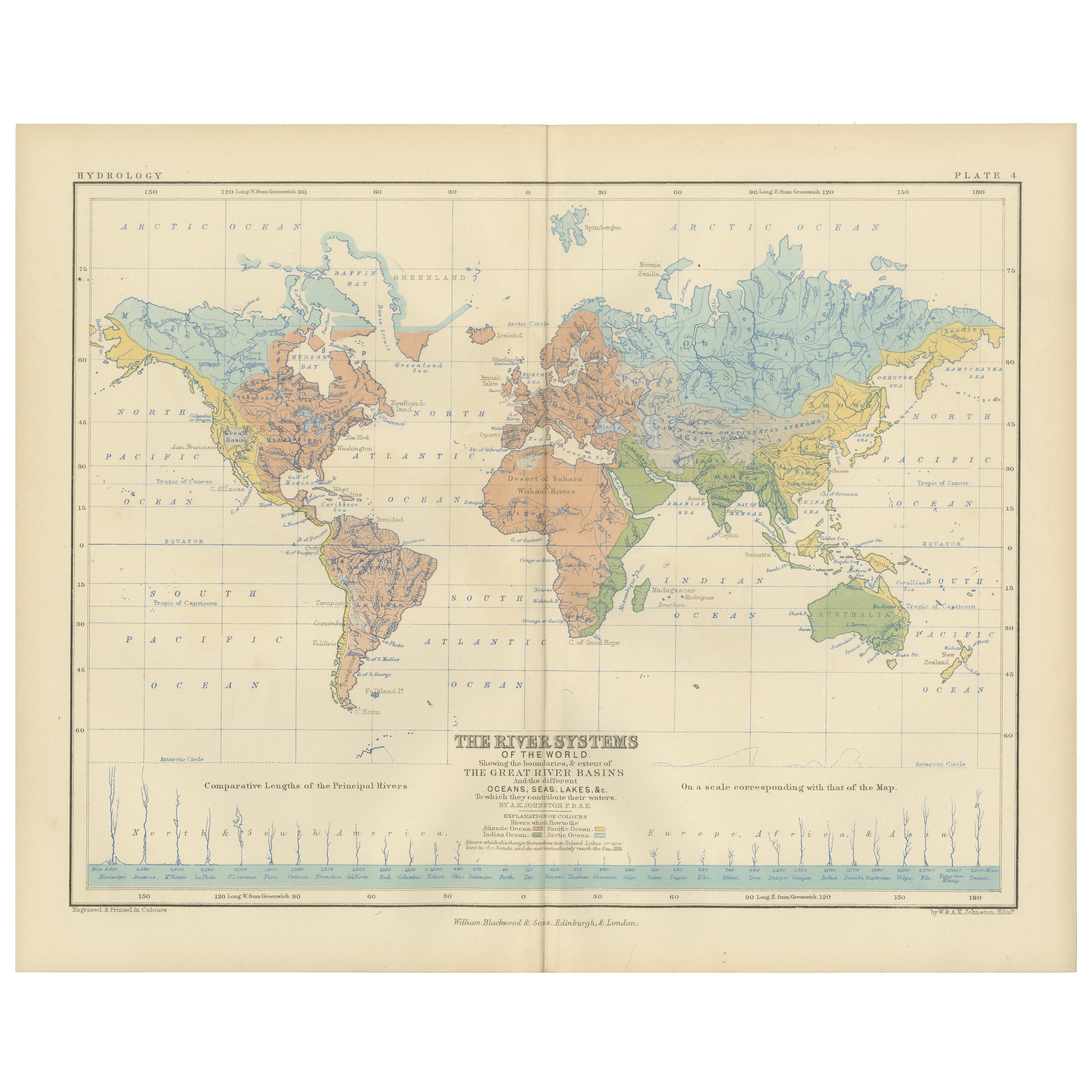
River Systems Map of the World by A.K. Johnston – Educational Print 1852
River Systems Map of the World by A.K. Johnston – Educational Print 1852
This striking 1852 map titled "The River Systems of the World" was created by the noted Scottish geographer ...
Catégorie
Antiquités, Milieu du XIXe siècle, Écossais, Estampes
Matériaux
Papier

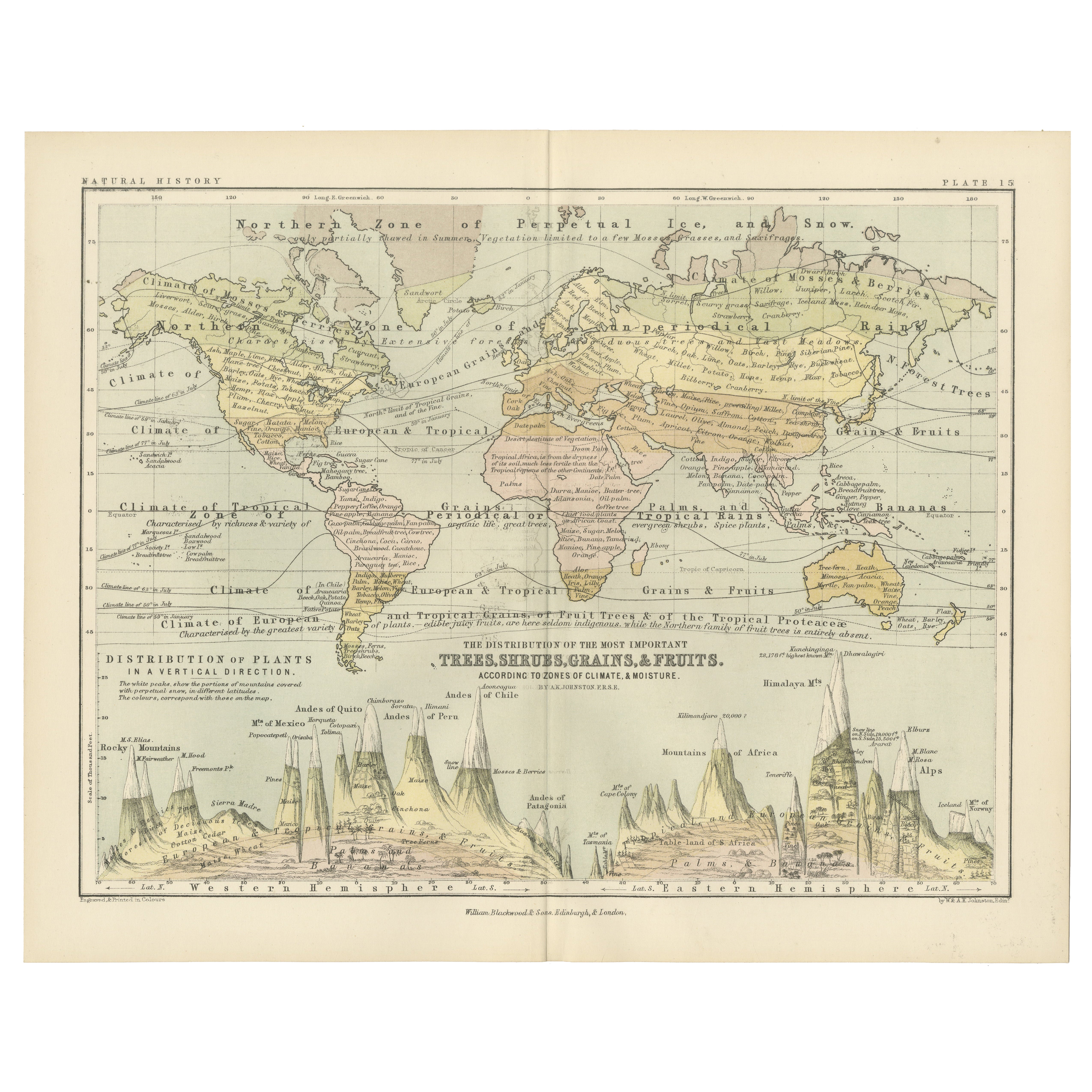
Botanical Map by A.K. Johnston – Global Plant Distribution Chart 1852
Botanical Map by A.K. Johnston – Global Plant Distribution Chart 1852
This remarkable antique chart titled "The Distribution of the Most Important Trees, Shrubs, Grains, & Fruits Ac...
Catégorie
Antiquités, Milieu du XIXe siècle, Écossais, Estampes
Matériaux
Papier
Suggestions
Carte du monde originale et ancienne par Dower, vers 1835
Belle carte du monde
Dessiné et gravé par J.Dower
Publié par Orr & Smith. C.1835
Non encadré.
Expédition gratuite
Catégorie
Antiquités, années 1830, Anglais, Cartes
Matériaux
Papier

Carte de l
Empire britannique ancien - Carte ancienne de Karl Spruner - 1760 environ
Par Karl Spruner von Merz
Old British Empire Map est une œuvre d'art réalisée vers 1760 par Karl Spruner.
Épreuve originale colorée à la main.
Bon état sauf un jaunissement du papier le long de la marge, et...
Catégorie
années 1760, Moderne, Estampes - Figuratif
Matériaux
Eau-forte

Grande carte ancienne originale du monde, Fullarton, vers 1870
Superbe carte du monde. Montrer les deux hémisphères
Extrait du célèbre Royal Illustrated Atlas
Lithographie. Couleur originale.
Publié par Fullarton, Edinburgh, C.1870.
Sans ca...
Catégorie
Antiquités, années 1870, Écossais, Cartes
Matériaux
Papier

Planisphere originale illustrée - Carte du monde - Géographie, 1864
Plongez dans l'épopée du passé avec le Planisphère historique illustré de 1864 par Charpentier ! 🗺️ Ce trésor cartographique vous transporte dans les méandres de l'histoire, avec de...
Catégorie
années 1860, Estampes et éditions
Matériaux
Lin, Papier, Lithographie

Carte ancienne originale de l
hémisphère oriental par Dower, vers 1835
Belle carte de l'hémisphère oriental
Dessiné et gravé par J.Dower
Publié par Orr & Smith. C.1835
Non encadré.
Expédition gratuite
Catégorie
Antiquités, années 1830, Anglais, Cartes
Matériaux
Papier

Carte originale et ancienne du monde par Thomas Clerk, 1817
Grande carte des hémisphères oriental et occidental
Sur 2 feuilles
Gravure sur cuivre
Dessiné et gravé par Thomas Clerk, Édimbourg.
Publié par Mackenzie et Dent, 1817
...
Catégorie
Antiquités, années 1810, Anglais, Cartes
Matériaux
Papier
