Articles similaires à 1870 "Johnson
s Europe" Map Published by A. J. Johnson


Vous voulez plus d
images ou de vidéos ?
Demander au vendeur plus d
images ou de vidéos
1 sur 10
1870 "Johnson
s Europe" Map Published by A. J. Johnson
1 094,98 €
À propos de cet article
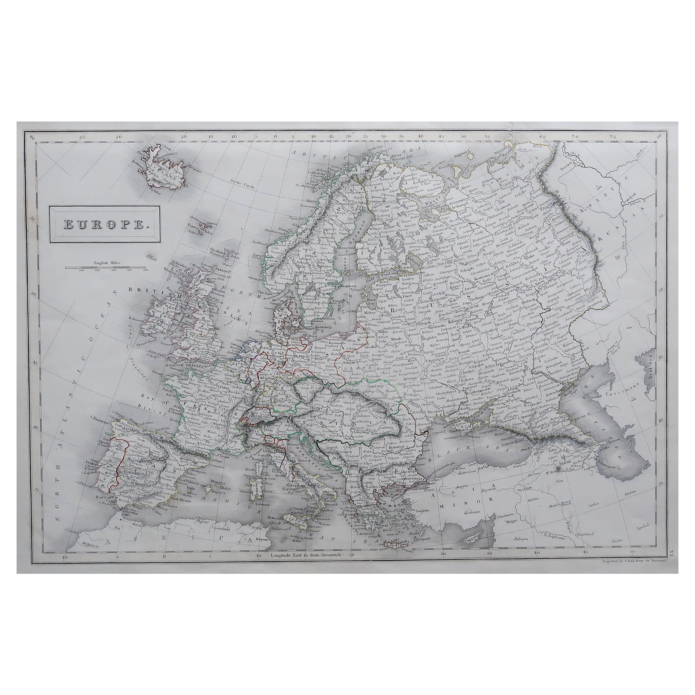
Presented is an original 1870 "Johnson’s Europe" map. First published in 1864, this map was issued as pages 87 and 88 in the 1870 edition of “Johnson's New Illustrated (Steel Plate) Family Atlas.” The map is engraved with attractive hand coloring and a decorative border. The countries of Europe are colored by country, and sometimes further colored by districts or rule. Included are the countries of Iceland, Ireland, England, Wales, Norway, Sweden, Russia, Prussia, Holland, Belgium, Bavaria, Austria, Switzerland, France, Italy, Spain, Portugal, Corsica, Sardinia, Turkey, Greece, and Crete. Russia is very large, divided by provinces, and includes within its borders Finland, Lapland, Baltic Provinces, Poland, West Russia, Little Russia, South Russia, Caucasian Provinces, Astrachan, and Kasan. Depicted but not colored are the border countries and continents of Greenland, Asia, Turkey in Asia, and Africa. The map is beautifully detailed, with cities, towns, railroads, and common roads identified, and mountains, rivers, and lakes depicted.
The publishing company of A.J. Johnson was a successor of Johnson and Ward, a successor to Johnson and Browning, themselves a successor to the famous publishing company, J. H. Colton and Company. A combination of both new plates and older, updated ones, all of the maps in this famous 1870 atlas were compiled, drawn, and engraved under the supervision of A. J. Johnson.
This 1870 publication of “Johnson's New Illustrated (Steel Plate) Family Atlas” is also notable for its inclusion of a treatise on physical geography by Professor A. Guyot, marking the first year his essay appeared and his name featured on the cover. The atlas was recognized with a First Prize Medal at the Universal Exposition of 1867 in Paris.
“Johnson's New Illustrated Family Atlas” was a comprehensive world atlas featuring 60 full-color maps. Designed to be both educational and a decorative addition to a home library, it reflected the 19th-century fascination with detailed and ornate cartographic publications. In addition to maps, the atlas included geographical, statistical, and historical information, as well as a dictionary of religious denominations, a testament to its extensive scope and utility. The treatise on physical geography by A. Guyot further demonstrates that period’s growing interest in scientific inquiry, making the atlas a valuable resource not just for navigation and geography, but also for understanding the natural world.
CONDITION:
Near fine condition. Hand Colored. Page 87 and 88 from “Johnson's New Illustrated (Steel Plate) Family Atlas.” Decorative border. Colored by country or province. Publication line: "Entered according to Act of Congress in the Year 1864, by A.J. Johnson, in the Clerks Office of the District Court of the United States for the Southern District of New York". Toning to paper, full margins, light staining at top.
Artfully framed in a custom-built wooden frame with UV glass and acid-free mats.
Framed Dimensions: 25 3/4"H x 31 3/4"W x 1 1/8"D.
Accompanied by our company's letter of authenticity.
- Dimensions:Hauteur : 65,41 cm (25,75 po)Largeur : 80,65 cm (31,75 po)Profondeur : 2,88 cm (1,13 po)
- Style:Victorien (De la période)
- Matériaux et techniques:Papier,Gravé
- Lieu d origine:
- Période:
- Date de fabrication:1870
- État:Ajouts ou modifications apportés à l original: Framed to archival and conservation standards by Artem Art Services in Colorado Springs CO in November of 2025. Usure conforme à l âge et à l utilisation. Décoloration mineure.
- Adresse du vendeur:Colorado Springs, CO
- Numéro de référence:Vendeur : M4321stDibs : LU909747859962
À propos du vendeur
4,9
Vendeur Or
Vendeurs premium dont la note est supérieure à 4,3 et le délai de réponse de 24 heures maximum
Établi en 2010
Vendeur 1stDibs depuis 2011
470 ventes sur 1stDibs
Temps de réponse habituel : 5 heures
- ExpéditionRecherche du devis...Expédition depuis : Colorado Springs, CO
- Politique des retours
Certaines parties de cette page ont été traduites automatiquement. 1stDibs ne garantit pas l
exactitude des traductions. L
anglais est la langue par défaut de ce site web.
Plus d articles de ce vendeur
Tout afficher1866 Carte des États-Unis de Johnson, publiée par Johnson et Ward
Voici une carte détaillée des États-Unis réalisée par A. J. Johnson. Couvrant l'ensemble du territoire continental des États-Unis, ainsi que les parties adjacentes du Canada et du Me...
Catégorie
Antiquités, années 1860, Américain, Victorien, Cartes
Matériaux
Papier

1870 "Johnson
s World" par le professeur A. Guyot, publié par J. A Johnson
L'ouvrage présenté est un original de "Johnson's World, Showing the Distribution of the Characteristic Forest Trees, Principal Useful Plants and Minerals" par le professeur A. Guyot....
Catégorie
Antiquités, années 1870, Américain, Victorien, Cartes
Matériaux
Papier
1856 "Map of the United States" par Ensign, Bridgeman et Fanning
Voici une rare carte murale des États-Unis et du Mexique publiée par Ensign, Bridgman et Fanning en 1856. Comme le titre l'indique, la carte couvre tous les États-Unis, ainsi que le ...
Catégorie
Antiquités, années 1850, Américain, Victorien, Cartes
Matériaux
Papier

Carte d
Amérique du Nord de 1864, carte ancienne colorée à la main, par Adolphe Hippolyte Dufour
La carte proposée est une carte de l'Amérique du Nord intitulée Amerique du Nord, datant de 1864. Cette carte murale rare, publiée séparément, a été réalisée par Adolphe Hippolyte Du...
Catégorie
Antiquités, années 1860, Français, Cartes
Matériaux
Papier

« Map of the United States of America..." de 1859 par J. H. Colton
Par J.H. Colton
La carte présentée est une "Carte des États-Unis d'Amérique, des provinces britanniques, du Mexique, des Antilles et de l'Amérique centrale avec une partie de la Nouvelle-Grenade et ...
Catégorie
Antiquités, années 1850, Américain, Cartes
Matériaux
Papier

Carte du Texas de 1894
Voici une carte très détaillée du Texas, datant de 1894. La carte est très complète, colorée par comtés et délimitée en rouge. La carte montre la topographie, les rivières, les sourc...
Catégorie
Antiquités, années 1890, Américain, Victorien, Cartes
Matériaux
Papier
Suggestions
Carte ancienne d
Europe par Johnson,
1872
Carte ancienne intitulée "Johnson's Europe". Carte originale de l'Europe. Cette carte provient du "Johnson's New Illustrated Family Atlas of the World" d'A.J. Johnson. Publié en 1872.
Catégorie
Antiquités, Fin du XIXe siècle, Cartes
Matériaux
Papier

280 € Prix de vente
20 % de remise
Carte ancienne du continent européen, 1882
Carte ancienne intitulée "Europe". Ancienne carte du continent européen. Cette carte est tirée de "The Royal Atlas of Modern Geography, Exhibiting, in a Series of Entirely Original a...
Catégorie
Antiquités, XIXe siècle, Cartes
Matériaux
Papier

Grande carte ancienne originale d
Europe par Sidney Hall, 1847
Grande carte de l'Europe
Dessiné et gravé par Sidney Hall
Gravure sur acier
Schéma de couleur original
Publié par A & C Black. 1847
Non encadré
Livraison gratuite....
Catégorie
Antiquités, années 1840, Écossais, Cartes
Matériaux
Papier

Carte ancienne du continent d
Europe, 1880
Carte ancienne intitulée "Europe". Ancienne carte du continent européen. Cette carte provient de la "Géographie Universelle Atlas-Migeon" de J. Migeon.
Artistes et graveurs : Publ...
Catégorie
Antiquités, XIXe siècle, Cartes
Matériaux
Papier

Carte ancienne d
Europe par W. G. Blackie, 1859
Carte ancienne intitulée "Europe". Carte ancienne originale de l'Europe. Cette carte provient de l'"Atlas impérial de géographie moderne". Publié par W. G. Blackie, 1859.
Catégorie
Antiquités, Milieu du XIXe siècle, Cartes
Matériaux
Papier

200 € Prix de vente
20 % de remise
Carte ancienne d
Europe provenant d
une vieille école néerlandaise-Atlas, 1852
Carte ancienne intitulée "Europa". Carte de l'Europe. Cette carte provient du "School-Atlas van alle deelen der Aarde" d'Otto Petri.
Artistes et graveurs : Publié par A. Baedeker...
Catégorie
Antiquités, XIXe siècle, Cartes
Matériaux
Papier
