Articles similaires à Carte ancienne de la Hongrie et de la Transylvanie par Isaak Tirion, Amsterdam c.C.


Chargement de la vidéo
Vous voulez plus d
images ou de vidéos ?
Demander au vendeur plus d
images ou de vidéos
1 sur 11
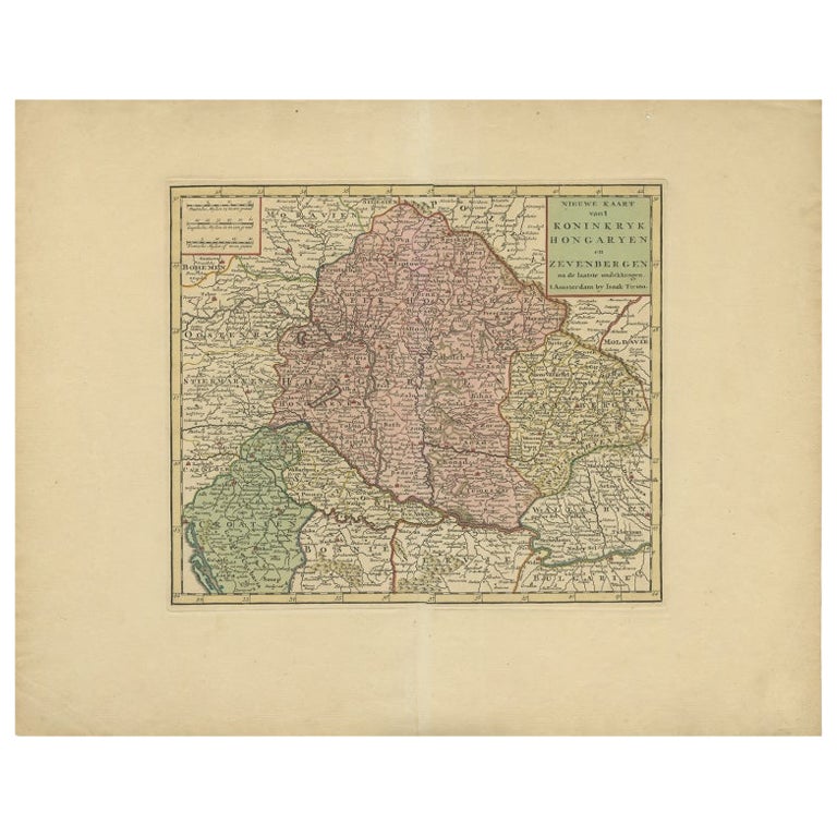
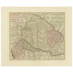
Carte ancienne de la Hongrie et de la Transylvanie par Isaak Tirion, Amsterdam c.C.
590 €TVA incluse
À propos de cet article
Poland Map 1740s – Nieuwe Kaart van het Koninryk Poolen by Isaak Tirion
This finely engraved and attractively hand-colored map of the Kingdom of Poland was published by Isaak Tirion in Amsterdam in the mid-18th century, likely around the 1740s. Titled in Dutch as 'Nieuwe Kaart van het Koninryk Poolen', the map presents an accurate and beautifully detailed rendering of Poland and its constituent voivodeships (Way-woodschaappen), as they existed prior to the partitions that would later redefine the region.
The map shows the eastern territories of the Polish–Lithuanian Commonwealth, including areas of modern-day Poland, Lithuania, Belarus, and western Ukraine. Political boundaries are clearly delineated in original outline color, with provinces shaded in soft pastels—pink, green, yellow, and blue—allowing the viewer to distinguish between major regions such as Lithuania, Mazovia, and Podolia. The map is densely engraved with towns, rivers, mountain ranges, and forests, reflecting the high standard of geographic accuracy for which Tirion was renowned.
The title cartouche in the upper left corner is both informative and elegant, printed in Dutch and emphasizing the map’s reliability and use of the latest sources available at the time. Isaak Tirion (1705–1765) was a prominent Amsterdam-based publisher whose atlases and historical works remain prized for their craftsmanship and clarity. This map appeared in his 'Hedendaagsche Historie' or 'Nieuwe en Beknopte Hand-Atlas'.
Condition:
This antique map is in very good condition with wide margins, strong plate impression, and fresh original hand color. Very minimal foxing or age toning is visible, and the sheet remains clean and structurally sound. One small hole in the fold. No tears or repairs are present.
Framing Tips:
This historic map is well suited for framing in a simple, narrow black or gold moulding to match its cartographic elegance. A soft cream or pale beige mat will complement the pastel tones while keeping the focus on the detail. Ideal for a study, library, or office, this map is a refined collector’s item for those interested in Polish or Eastern European history.
- Dimensions:Hauteur : 41,6 cm (16,38 po)Largeur : 50,5 cm (19,89 po)Profondeur : 0,2 mm (0,01 po)
- Matériaux et techniques:Papier,Gravé
- Lieu d origine:
- Période:
- Date de fabrication:circa 1740
- État:This antique map is in very good condition with wide margins, strong plate impression, and fresh original hand color. Very minimal foxing or age toning is visible, and the sheet remains clean and structurally sound. One small hole in the fold.
- Adresse du vendeur:Langweer, NL
- Numéro de référence:Vendeur : BG-14031-41stDibs : LU3054345438252
À propos du vendeur
5,0
Vendeur reconnu
Ces vendeurs prestigieux sont des leaders du secteur. Ils représentent le summum en matière de qualité et de design.
Vendeur Platine
Vendeurs premium dont la note est supérieure à 4,7 et le délai de réponse de 24 heures maximum
Établi en 2009
Vendeur 1stDibs depuis 2017
2 842 ventes sur 1stDibs
Temps de réponse habituel : 1 heure
- ExpéditionRecherche du devis...Expédition depuis : Langweer, Pays-Bas
- Politique des retours
Certaines parties de cette page ont été traduites automatiquement. 1stDibs ne garantit pas l
exactitude des traductions. L
anglais est la langue par défaut de ce site web.
Plus d articles de ce vendeur
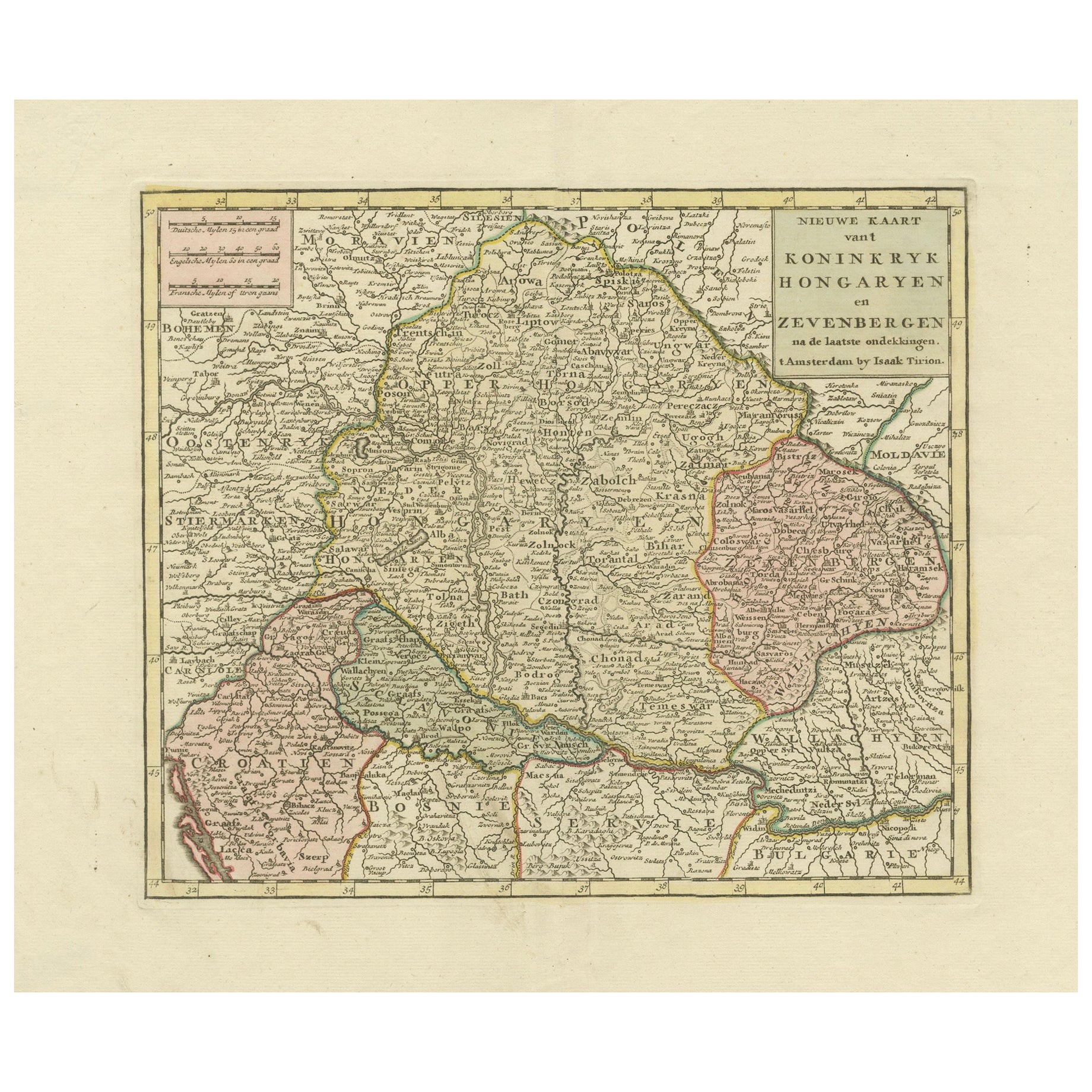
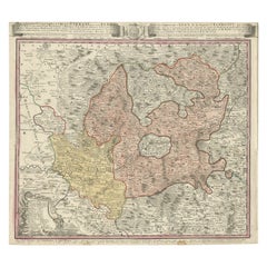
Tout afficherCarte ancienne de Hongrie entourant des contours comme Croatie, Bosnie, Servie, 1730
Carte ancienne intitulée "Nieuwe Kaart van t Koninkryk Hongaryen en Zevenbergen na de laatste ontdekkingen".
Cette carte représente la Hongrie et ses environs, notamment la Croatie...
Catégorie
Antiquités, XVIIIe siècle, Cartes
Matériaux
Papier

Carte ancienne détaillée de Hongrie et de Transylvanie par Tirion, 1753
Titre : Nieuwe Kaart van't Koninkryk Hongaryen en Zevenbergen par Isaak Tirion, 1753 - Carte ancienne de la Hongrie et de la Transylvanie
Description : Il s'agit d'une carte ancie...
Catégorie
Antiquités, années 1750, Cartes
Matériaux
Papier
483 € Prix de vente
30 % de remise
Carte ancienne du Royaume de Hongrie par Keizer
de Lat, 1788
Carte ancienne intitulée "t Koninkryk Hongarien (..)". Carte ancienne originale peu commune du Royaume de Hongrie. Cette carte provient du "Nieuwe Natuur- Geschied- en Handelkundige ...
Catégorie
Antiquités, Fin du XVIIIe siècle, Cartes
Matériaux
Papier

280 € Prix de vente
20 % de remise
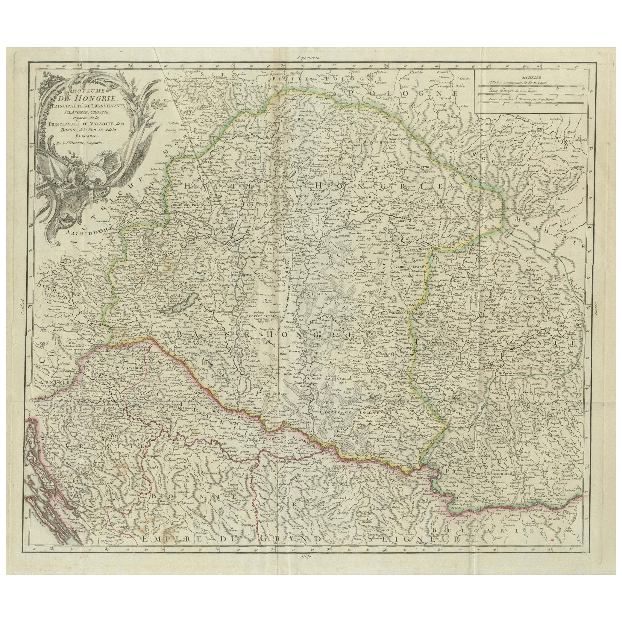
Carte ancienne du Royaume de Hongrie et de Transylvanie, vers 1780
Carte ancienne du Royaume de Hongrie et des régions avoisinantes par S. Robert, circa 1780
Cette magnifique carte gravée intitulée Royaume de Hongrie, Principauté de Transilvanie, E...
Catégorie
Antiquités, Fin du XVIIIe siècle, Français, Cartes
Matériaux
Papier

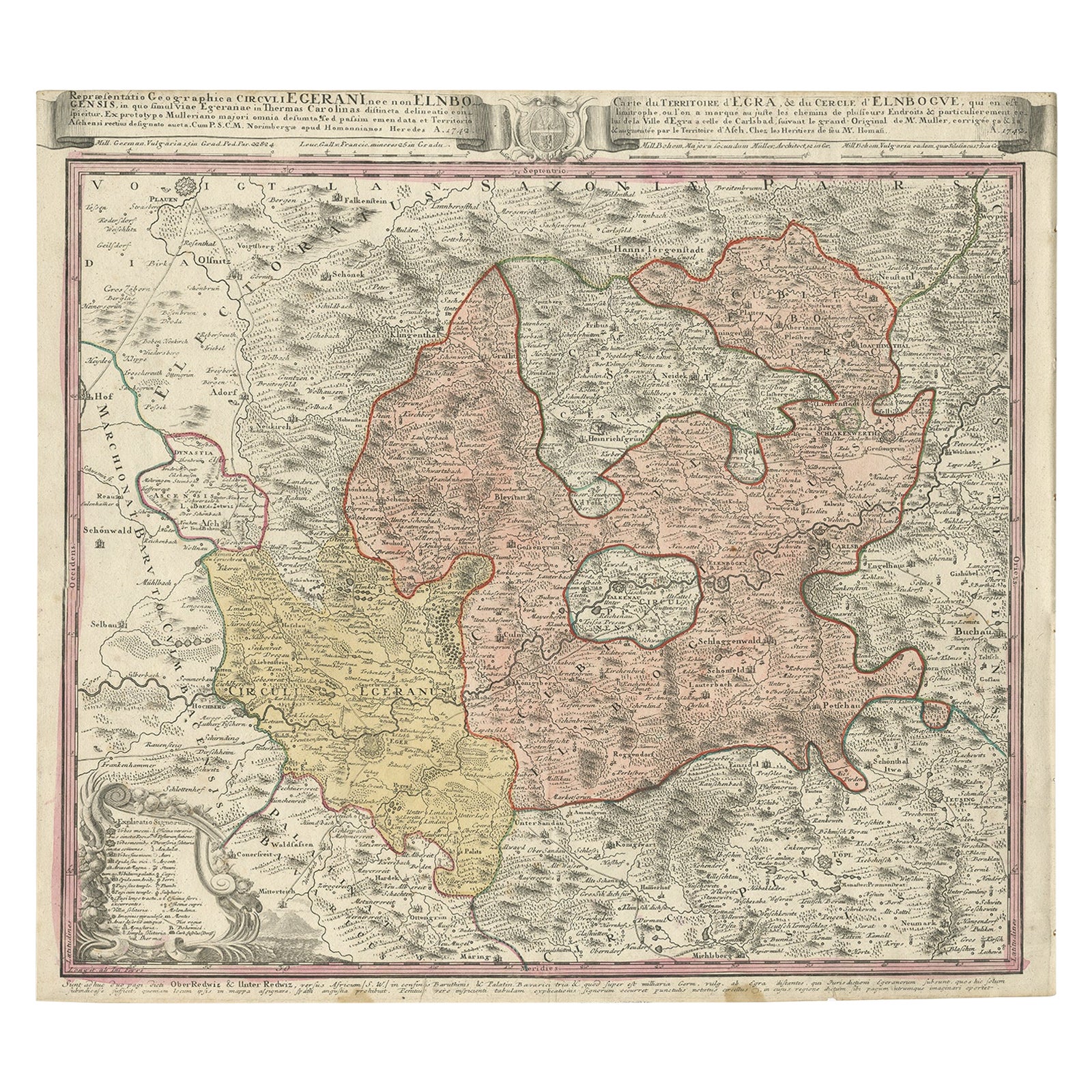
Carte ancienne de la région d
Elbogen et d
Eger, République tchèque et Hongrie, 1742
Carte ancienne intitulée "Repraesentatio Geographica Circuli Egerani, nec non Elnbogensis : in quo simul viae Egeranae in Thermas Carolinas distincta delineatio conspicitur (...)".
...
Catégorie
Antiquités, années 1740, Cartes
Matériaux
Papier
432 € Prix de vente
20 % de remise
Carte ancienne de l
Autriche par F. de Wit, 1690
Carte ancienne intitulée "Circuli Austriaci pars Septentrionalis in qua Archiducatus". Carte décorative et détaillée de l'Autriche par F. de Wit.
Catégorie
Antiquités, Fin du XVIIe siècle, Néerlandais, Cartes
Matériaux
Papier

Suggestions
Carte ancienne originale de Hongrie, orfèvrerie, 1820
Grande carte de la Hongrie
Dessiné sous la direction d'Arrowsmith.
Gravure sur cuivre.
Publié par Longman, Hurst, Rees, Orme et Brown, 1820
Non encadré.
Catégorie
Antiquités, années 1820, Anglais, Cartes
Matériaux
Papier

Carte Homann d
Autriche du 18e siècle colorée à la main, comprenant Vienne et le Danube
Par Johann Baptist Homann
"Archiducatus Austriae inferioris" est une carte de l'Autriche coloriée à la main, créée par Johann Baptist Homann (1663-1724) et publiée à Nuremberg, en Allemagne, en 1728, peu aprè...
Catégorie
Antiquités, Début du XVIIIe siècle, Allemand, Cartes
Matériaux
Papier

Carte Homann du 18e siècle, colorée à la main, représentant l
Allemagne, y compris Francfort et Berlin
Par Johann Baptist Homann
Carte coloriée à la main du XVIIIe siècle intitulée "Tabula Marchionatus Brandenburgici et Ducatus Pomeraniae quae sunt Pars Septentrionalis Circuli Saxoniae Superioris" par Johann B...
Catégorie
Antiquités, Début du XVIIIe siècle, Allemand, Cartes
Matériaux
Papier

Carte de Thomas Stackhouse de 1790, intitulée « Russie en Europe, », Ric.a004
1790 Carte de Thomas Stackhouse, intitulée
"La Russie en Europe
Ric.a004
Stackhouse, Thomas
La Russie en Europe [carte]
Londres : AT&T, 1783. Carte. Gravure sur cuivre color...
Catégorie
Antiquités, 17ème siècle, Inconnu, Cartes
Matériaux
Papier

Carte colorée à la main d
une région de l
ouest de l
Allemagne du XVIIe siècle par Janssonius
Par Johannes Janssonius
Cette attrayante carte originale du XVIIe siècle, très détaillée et colorée à la main, est intitulée "Archiepiscopatus Maghdeburgensis et Anhaltinus Ducatus cum terris adjacentibus"....
Catégorie
Antiquités, Milieu du XVIIe siècle, Néerlandais, Cartes
Matériaux
Papier

1752 Carte de Vaugoundy des Flandres : Belgique, France et Pays-Bas, Ric.a002
Grande carte des Flandres de Vaugoundy :
Belgique, France et Pays-Bas
Coloré -1752
Ric.a002
Description : Il s'agit d'une carte des Flandres de Didier Robert de Vaugondy de 1...
Catégorie
Antiquités, 17ème siècle, Inconnu, Cartes
Matériaux
Papier
