Articles similaires à Carte ancienne originale de la Moscovie ou de la Russie par Isaak Tirion, Amsterdam circa 1740


Chargement de la vidéo
Vous voulez plus d
images ou de vidéos ?
Demander au vendeur plus d
images ou de vidéos
1 sur 11
Carte ancienne originale de la Moscovie ou de la Russie par Isaak Tirion, Amsterdam circa 1740
790 €TVA incluse
À propos de cet article
Map of Muscovy or Russia by Isaak Tirion, Amsterdam circa 1740
Description:
This beautifully engraved and delicately hand-colored map titled "Nieuwe Kaart van Muskovië of Rusland" was published in Amsterdam by Isaak Tirion around 1740. It presents a remarkably detailed depiction of the vast territories of the Russian Empire in the early 18th century, during a period of dynamic geopolitical change and territorial expansion under the Romanov dynasty.
The map spans from the borders of Poland and the Baltic states in the west to the steppes and semi-mythical territories of Tartary and Siberia in the east. Major cities such as Moscow and Novgorod are clearly marked, along with numerous rivers, mountain ranges, lakes, and political subdivisions. The map offers both geographic precision and a romanticized vision of the Russian realm as perceived by Western European cartographers of the Enlightenment.
Tirion, one of the foremost Dutch publishers of the 18th century, is known for his careful engraving and well-proportioned compositions. The map is framed by a fine border, and a clean title cartouche in the lower right corner contains the Dutch-language title and publishing credit. The hand-applied color accents help differentiate the provinces and give visual depth to the mountainous and forested areas.
This map is not only an aesthetically pleasing decorative piece but also a valuable historical artifact. It provides insights into how Russia was viewed and mapped by contemporary European geographers at a time when its imperial ambitions were reshaping Eurasia.
Condition summary:
Good condition overall, with original hand coloring and wide margins. Some mild toning and a faint central fold line, as issued. Minimal edge wear and light creasing in the margins, but the printed area remains clean and crisp.
Framing suggestion:
A dark wood or mahogany frame with a soft ivory mat would enhance the warm tones of the paper and highlight the map’s fine detailing. For a classic look, consider adding a thin gold filet. This map would suit a library, study, or any space with an interest in early European history or exploration.
- Dimensions:Hauteur : 38,7 cm (15,24 po)Largeur : 48 cm (18,9 po)Profondeur : 0,2 mm (0,01 po)
- Matériaux et techniques:Papier,Gravé
- Lieu d origine:
- Période:
- Date de fabrication:circa 1740
- État:Good condition overall, with original hand coloring and wide margins. Some mild toning and a faint central fold line, as issued. Minimal edge wear and light creasing in the margins, but the printed area remains clean and crisp.
- Adresse du vendeur:Langweer, NL
- Numéro de référence:Vendeur : BG-14031-31stDibs : LU3054345438442
À propos du vendeur
5,0
Vendeur reconnu
Ces vendeurs prestigieux sont des leaders du secteur. Ils représentent le summum en matière de qualité et de design.
Vendeur Platine
Vendeurs premium dont la note est supérieure à 4,7 et le délai de réponse de 24 heures maximum
Établi en 2009
Vendeur 1stDibs depuis 2017
2 852 ventes sur 1stDibs
Temps de réponse habituel : 1 heure
- ExpéditionRecherche du devis...Expédition depuis : Langweer, Pays-Bas
- Politique des retours
Certaines parties de cette page ont été traduites automatiquement. 1stDibs ne garantit pas l
exactitude des traductions. L
anglais est la langue par défaut de ce site web.
Plus d articles de ce vendeur
Tout afficherCarte ancienne de la Russie européenne par Tirion, datant d
environ 1725
Carte ancienne intitulée "Nieuwe Kaart van Muskovie of Rusland na de laatste ondekking int licht gebracht te Amsterdam by Isaak Tirion". Carte détaillée de la Russie européenne.
...
Catégorie
Antiquités, XVIIIe siècle, Cartes
Matériaux
Papier

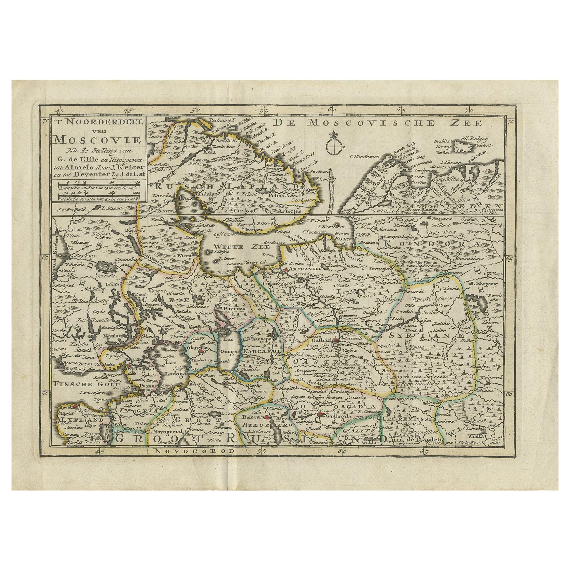
Carte ancienne de Muscovy du Nord par Keizer
de Lat, 1788
Carte ancienne intitulée "t Noorderdeel van Moscovie (..)". Carte ancienne originale peu commune du Nord de la Moscovie, Russie. Cette carte provient du "Nieuwe Natuur- Geschied- en ...
Catégorie
Antiquités, Fin du XVIIIe siècle, Cartes
Matériaux
Papier
280 € Prix de vente
20 % de remise
Carte ancienne de Moscovy « Russie » par E. Bowen, 1747
Belle carte de la Russie européenne par le cartographe anglais Emmanuel Bowen. Il représente la partie européenne de la Russie, qui s'étend du golfe de Finlande aux montagnes de l'Ou...
Catégorie
Antiquités, Milieu du XVIIIe siècle, Cartes
Matériaux
Papier

Carte du duché de Poméranie - Gravure ancienne de P.I.C., vers 1750
Carte du duché de Poméranie - Gravure ancienne de P.I.C., vers 1750
Carte ancienne intitulée "Ducatus Pomeraniae Tabula Generalis". Cette carte historique présente le duché de Pomér...
Catégorie
Antiquités, Milieu du XVIIIe siècle, Néerlandais, Cartes
Matériaux
Papier

Carte ancienne de Russie par N. Sanson, 1705
Carte fortement gravée de la Russie européenne montrant ses divisions politiques, ses principales caractéristiques topographiques, ses villes et ses villages. S'étend jusqu'à la mer ...
Catégorie
Antiquités, Début du XVIIIe siècle, Français, Cartes
Matériaux
Papier

Carte ancienne d
une partie de l
Allemagne par Moll, vers 1740
Carte ancienne de l'Allemagne intitulée "The North West Part of Germany ; Containing ye Dominions of ye Arch : and El : of Cologne, Westphalia, / Juliers, Cleeves, Munster, Osnaburgh...
Catégorie
Antiquités, XVIIIe siècle, Cartes
Matériaux
Papier

92 € Prix de vente
20 % de remise
Suggestions
Carte colorée à la main d
une région de l
ouest de l
Allemagne du XVIIe siècle par Janssonius
Par Johannes Janssonius
Cette attrayante carte originale du XVIIe siècle, très détaillée et colorée à la main, est intitulée "Archiepiscopatus Maghdeburgensis et Anhaltinus Ducatus cum terris adjacentibus"....
Catégorie
Antiquités, Milieu du XVIIe siècle, Néerlandais, Cartes
Matériaux
Papier

Prusse, Pologne, Allemagne, N. , E. : Carte du XVIIe siècle colorée à la main par Janssonius
Par Johannes Janssonius
Il s'agit d'une jolie carte de la Prusse du XVIIe siècle, gravée sur cuivre et colorée à la main, intitulée "Prussia Accurate Descripta a Gasparo Henneberg Erlichensi", publiée à Ams...
Catégorie
Antiquités, Milieu du XVIIe siècle, Néerlandais, Cartes
Matériaux
Papier

Carte de Thomas Stackhouse de 1790, intitulée « Russie en Europe, », Ric.a004
1790 Carte de Thomas Stackhouse, intitulée
"La Russie en Europe
Ric.a004
Stackhouse, Thomas
La Russie en Europe [carte]
Londres : AT&T, 1783. Carte. Gravure sur cuivre color...
Catégorie
Antiquités, 17ème siècle, Inconnu, Cartes
Matériaux
Papier

Carte Homann du 18e siècle, colorée à la main, représentant l
Allemagne, y compris Francfort et Berlin
Par Johann Baptist Homann
Carte coloriée à la main du XVIIIe siècle intitulée "Tabula Marchionatus Brandenburgici et Ducatus Pomeraniae quae sunt Pars Septentrionalis Circuli Saxoniae Superioris" par Johann B...
Catégorie
Antiquités, Début du XVIIIe siècle, Allemand, Cartes
Matériaux
Papier

Carte de « Russie en Europe incluant la Pologne » Ric.r016, 1853
Description
Russia in Europe incl. Poland by J Wyld c.1853
Gravure sur acier colorée à la main
Dimension : Papier : 25 cm L x 33 cm H ; Vue : 22 cm L x 28 cm H
Conditio...
Catégorie
Antiquités, XIXe siècle, Inconnu, Cartes
Matériaux
Papier

Scandinavie
Portions of Eastern Europe : Carte Homann du 18e siècle colorée à la main
Par Johann Baptist Homann
Carte du début du XVIIIe siècle, colorée à la main et gravée sur cuivre, intitulée "Regni Sueciae in omnes suas Subjacentes Provincias accurate divisi Tabula Generalis" par Johann Ba...
Catégorie
Antiquités, Début du XVIIIe siècle, Allemand, Cartes
Matériaux
Papier
