Articles similaires à Egypt
Abyssinia – Original Nile Valley and Horn of Africa Maps, c.1817


Vous voulez plus d
images ou de vidéos ?
Demander au vendeur plus d
images ou de vidéos
1 sur 9
Egypt
Abyssinia – Original Nile Valley and Horn of Africa Maps, c.1817
550 €TVA incluse
À propos de cet article
Egypt
Abyssinia – Nile Valley and Horn of Africa Maps, c.1817–1820
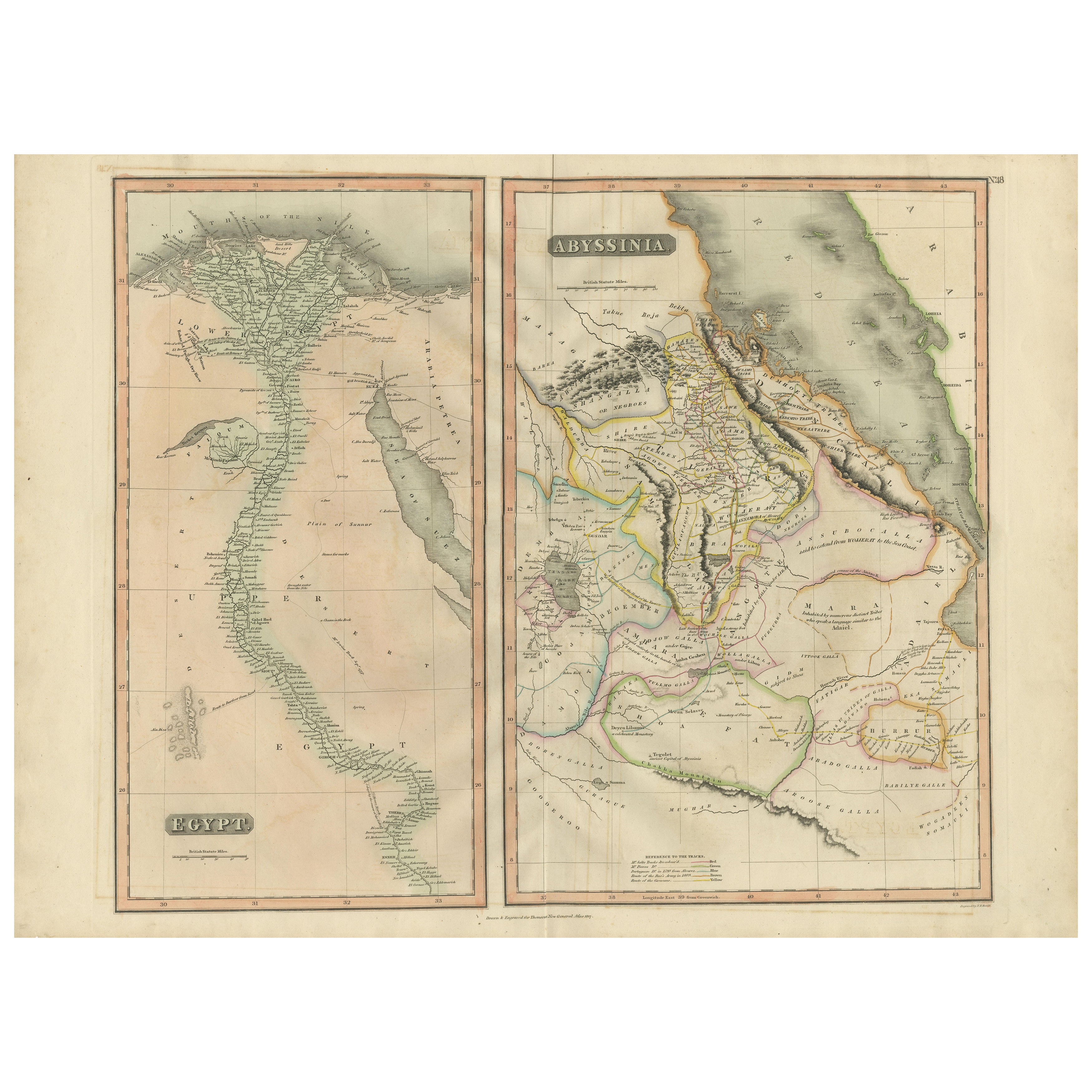
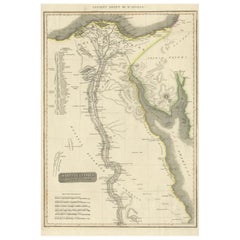
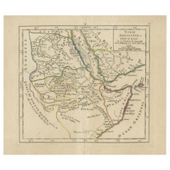
This refined early 19th-century map composition presents two related geographic views of Northeast Africa: Egypt with the full course of the Nile River, and Abyssinia (Ethiopia) with the Horn of Africa and Red Sea coast. Issued as companion maps circa 1817–1820, the sheets offer a clear and elegant overview of one of the most historically and geographically significant regions of Africa.
The Egypt map focuses on the Nile Valley from the Mediterranean Delta southward into Upper Egypt, emphasizing the river’s role as the organizing axis of settlement, agriculture, and civilization. Cities, river branches, desert regions, and historic sites are carefully engraved, creating a calm vertical composition that highlights the Nile’s uninterrupted flow through the landscape.
The Abyssinia map complements this view by presenting Ethiopia and the Horn of Africa, including the Red Sea coastline, inland mountain ranges, river systems, and regional boundaries. Political divisions are delicately outlined in contemporary hand color, distinguishing provinces and neighboring territories while maintaining visual clarity. Together, the two maps provide a balanced perspective on the Nile’s sources, surrounding highlands, and the broader Northeast African context.
The engraving style is clean and legible, characteristic of early 19th-century British atlas cartography, combining scientific precision with restrained elegance. Subtle hand coloring enhances coastlines and borders without overpowering the geography. When viewed together, the tall vertical Egypt map and the more compact Abyssinia map create a visually pleasing contrast that works exceptionally well for interior display.
This paired presentation appeals to collectors of African cartography, Nile history, and Ethiopian history, while also offering strong decorative value for both classic and contemporary interiors. Displayed side by side, the maps form a coherent and visually harmonious statement piece.
Condition report
Good condition overall. Central vertical folds as issued. Light age toning and some mild discoloration, more noticeable on the Egypt sheet. Minor scattered spots and light handling marks. Original outline hand color. Plate marks visible. Margins intact.
Framing tips
These maps work beautifully framed as a pair. Use matching off-white or light sand-colored mats to unify the presentation while allowing each map to breathe. Medium to dark wood frames or softly ebonized frames enhance the engraved detail and create a refined, gallery-ready appearance suitable for residential or hospitality interiors.
Technique: Copper engraving with contemporary outline hand color
Maker: British school (Thomson), c.1817
- Dimensions:Hauteur : 54 cm (21,26 po)Largeur : 71,5 cm (28,15 po)Profondeur : 0,2 mm (0,01 po)
- Matériaux et techniques:Papier,Gravé
- Lieu d origine:
- Période:
- Date de fabrication:circa 1817
- État:Good condition overall. Vertical fold as issued. Light age toning and some mild discoloration, more noticeable on the Egypt sheet. Minor scattered spots and light handling marks. Original outline hand color. Plate marks visible. Margins intact.
- Adresse du vendeur:Langweer, NL
- Numéro de référence:Vendeur : BG-14128-121stDibs : LU3054348017432
À propos du vendeur
5,0
Vendeur reconnu
Ces vendeurs prestigieux sont des leaders du secteur. Ils représentent le summum en matière de qualité et de design.
Vendeur Platine
Vendeurs premium dont la note est supérieure à 4,7 et le délai de réponse de 24 heures maximum
Établi en 2009
Vendeur 1stDibs depuis 2017
2 836 ventes sur 1stDibs
Temps de réponse habituel : 1 heure
- ExpéditionRecherche du devis...Expédition depuis : Langweer, Pays-Bas
- Politique des retours
Certaines parties de cette page ont été traduites automatiquement. 1stDibs ne garantit pas l
exactitude des traductions. L
anglais est la langue par défaut de ce site web.
Plus d articles de ce vendeur
Tout afficherEgypt and Abyssinia – Nile Valley
Horn of Africa Maps, c.1817–1820
Egypt and Abyssinia – Nile Valley & Horn of Africa Maps, c.1817–1820
This refined early 19th-century paired map presents Egypt and Abyssinia (Ethiopia) as two complementary geograph...
Catégorie
Antiquités, années 1810, Britannique, Cartes
Matériaux
Papier
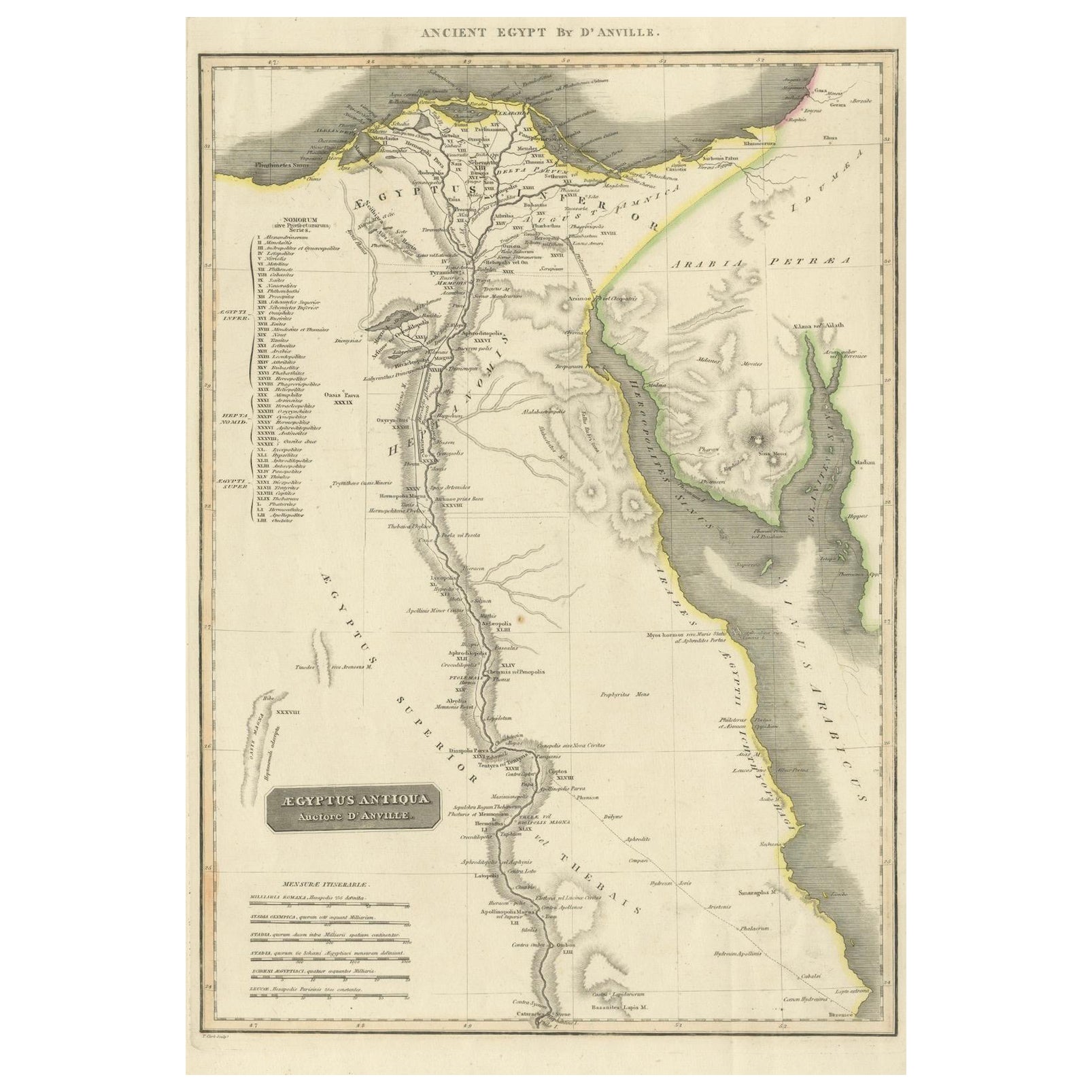
Ancient Egypt – Nile Valley Map by d’Anville, Classical Antiquity, c.1765
Ancient Egypt – Nile Valley Map by d’Anville, Classical Antiquity, c.1765
This finely engraved map depicts Ancient Egypt as understood through classical sources, extending along the...
Catégorie
Antiquités, années 1760, Français, Cartes
Matériaux
Papier
Carte ancienne de l
Égypte avec insertion détaillée du delta du Nil, vers 1799
Carte ancienne de l'Égypte avec insertion détaillée du delta du Nil, vers 1799
Cette carte ancienne finement gravée intitulée Carte Physique et Politique de l'Égypte présente une vu...
Catégorie
Antiquités, Début des années 1800, Français, Cartes
Matériaux
Papier

Egypt
Arabia Petraea – Large Nile Map, British Cartography, c.1815
Egypt & Arabia Petraea – Large Nile Map, British Cartography, c.1815
This impressive early 19th-century map depicts Egypt and Arabia Petraea with exceptional detail, extending from ...
Catégorie
Antiquités, années 1810, Britannique, Cartes
Matériaux
Papier

Grande carte ancienne de la vallée du Nile inférieur, comprenant l
Égypte et la Nubie, 1842
Carte ancienne intitulée "Carte de l'Égypte, de la Nubie, de l'Abissinie". Carte de l'Égypte, couvrant la basse vallée du Nil, y compris l'Égypte et la Nubie. Cette carte provient de...
Catégorie
Antiquités, XIXe siècle, Français, Cartes
Matériaux
Papier

360 € Prix de vente
20 % de remise
Carte ancienne de l
Anatolie, du Sudan et de la mer Rouge, de l
Arabie et de l
Égypte du Sud, 1749
Carte ancienne intitulée "Nubie, Abissinie et Cote d'Ajan". Carte de l'Abyssinie, du Soudan et de la mer Rouge par Robert Vaugondy. Il s'étend de l'Arabie et de l'Égypte jusqu'à Moga...
Catégorie
Antiquités, XVIIIe siècle, Cartes
Matériaux
Papier
Suggestions
Afrique. Part One. Carte vintage Atlas du XXe siècle
L'Atlas du siècle. Afrique. Partie nord-est
Carte originale ancienne, 1903.
Carte en médaillon du "Delta du Nil et du canal de Suez".
Pli central tel que publié. Le nom et le numér...
Catégorie
Début du 20ème siècle, Victorien, Plus d Estampes
Matériaux
Lithographie

Carte ancienne originale de l
Afrique par Dower, vers 1835
Belle carte de l'Afrique
Dessiné et gravé par J.Dower
Publié par Orr & Smith. C.1835
Non encadré.
Expédition gratuite
Catégorie
Antiquités, années 1830, Anglais, Cartes
Matériaux
Papier

Afrique. Part One. Carte vintage Atlas du XXe siècle
L'Atlas du siècle. Afrique. Partie sud
Carte originale ancienne, 1903.
Pli central tel que publié. Le nom et le numéro de la carte sont imprimés sur les coins du dos.
Feuille de 40...
Catégorie
Début du 20ème siècle, Victorien, Plus d Estampes
Matériaux
Lithographie

Carte de Nubia et d
Abissinia - gravure originale d
Antonio Zatta - 1784
Cette carte de Nubie et d'Abissinie est une gravure réalisée par Antonio Zatta à Venise en 1784.
L'état de conservation de l'œuvre est bon, à l'exception du papier usé avec quelques...
Catégorie
années 1770, Estampes - Paysage
Matériaux
Eau-forte

Ancienne carte italienne d
Asie comprenant la Chine, l
Indonésie et l
Inde, 1803
Ancienne carte italienne d'Asie comprenant la Chine, l'Indonésie et l'Inde, 1803
Très belle carte de l'Asie. 1803.
Informations complémentaires :
Type : Carte
Pays de fabrication :...
Catégorie
Antiquités, XIXe siècle, Européen, Cartes
Matériaux
Papier

384 € Prix de vente
39 % de remise
Carte de la Terre Sainte "Carte de la Syrie et de l
Égypte" de Pierre M. Lapie
Par Pierre M. Lapie
Carte du début du XIXe siècle de la Syrie et de l'Égypte anciennes intitulée "Carte de la Syrie et de l'Égypte anciennes/dressée par M. Lapie, Colonel d'État Major, et M. Lapie fils,...
Catégorie
Antiquités, Début du XIXe siècle, Français, Cartes
Matériaux
Papier
