Articles similaires à Ireland Antique Map – Royaume d’Irlande, De Vaugondy, Venice 1778


Vous voulez plus d
images ou de vidéos ?
Demander au vendeur plus d
images ou de vidéos
1 sur 11
Ireland Antique Map – Royaume d’Irlande, De Vaugondy, Venice 1778
640 €TVA incluse
À propos de cet article
Antique Map of Ireland – Royaume d’Irlande, Robert de Vaugondy, Venice 1778
Description:
This finely engraved 18th-century map depicts the Kingdom of Ireland under the title Royaume d’Irlande divisé en ses quatre Provinces et subdivisé en Comtés. The island is shown in impressive detail, with the traditional four provinces—Ulster, Connaught, Leinster, and Munster—clearly delineated and subdivided into counties by contemporary outline coloring. Coastal features, rivers, towns, and road networks are rendered with the clarity and balance typical of late Enlightenment French cartography.
The map was drawn by Robert de Vaugondy, one of the most influential mapmakers of the 18th century and royal geographer to the King of France. This Venetian edition was published in 1778 by Paolo Santini, who issued a number of high-quality Italian editions of leading French cartographic works. Santini’s publications are prized for their crisp engraving, generous format, and restrained coloring, making them particularly attractive for framing.
The decorative maritime cartouche, left uncolored as issued, provides a refined visual counterbalance to the densely engraved map surface. Longitude and latitude scales frame the composition, while inset coastal details along the eastern seaboard emphasize Ireland’s maritime orientation and strategic importance during the Georgian period. The overall aesthetic is elegant rather than ornate, lending the map strong decorative appeal for both classic and contemporary interiors.
This map sits at the intersection of political geography and decorative cartography, reflecting Ireland’s administrative structure in the late 18th century while remaining visually calm and highly legible. It works exceptionally well as a stand-alone wall piece in libraries, studies, hallways, or heritage-inspired interiors, and also pairs beautifully with maps of England or Scotland from the same period.
Condition report:
Good antique condition. Light, even age toning throughout. Original centerfold as issued. Minor handling wear and soft creases consistent with age. Contemporary outline coloring well preserved. No major tears or losses.
Framing tips:
This map benefits from a wide mat to emphasize its scale and clarity. Recommended combinations include a dark walnut or ebonized frame with an ivory or light parchment mat for a traditional library look, or a slim black frame with an off-white mat for a cleaner, architectural presentation. UV glass is advised to preserve the original coloring.
Technique: Copper engraving with contemporary outline coloring
Maker: Robert de Vaugondy, published by Paolo Santini, Venice, 1778
Keywords:
antique map of Ireland, antique Ireland map, Royaume d’Irlande map, Robert de Vaugondy Ireland, Santini Venice map, 18th century Ireland map, hand colored antique map, Georgian era cartography, historic Ireland wall map, European antique map, French cartographic school, Italian engraved map, copper engraved map, decorative antique map, neutral antique wall art, classic library wall decor, historic wall decor, heritage interior art, gentleman’s library wall art, study wall decor, old world interior decor, English country house style, refined wall map, vintage European wall art, timeless wall decor, architectural interior art, framed antique map, collector wall map, understated antique decor, European heritage wall art
- Dimensions:Hauteur : 48,5 cm (19,1 po)Largeur : 54,5 cm (21,46 po)Profondeur : 0,2 mm (0,01 po)
- Matériaux et techniques:Papier,Gravé
- Lieu d origine:
- Période:1770-1779
- Date de fabrication:1778
- État:Good antique condition. Light, even age toning throughout. Original centerfold as issued. Minor handling wear and soft creases consistent with age. Contemporary outline coloring well preserved. No major tears or losses.
- Adresse du vendeur:Langweer, NL
- Numéro de référence:Vendeur : BG-141541stDibs : LU3054348066062
À propos du vendeur
5,0
Vendeur reconnu
Ces vendeurs prestigieux sont des leaders du secteur. Ils représentent le summum en matière de qualité et de design.
Vendeur Platine
Vendeurs premium dont la note est supérieure à 4,7 et le délai de réponse de 24 heures maximum
Établi en 2009
Vendeur 1stDibs depuis 2017
2 813 ventes sur 1stDibs
Temps de réponse habituel : 1 heure
- ExpéditionRecherche du devis...Expédition depuis : Langweer, Pays-Bas
- Politique des retours
Certaines parties de cette page ont été traduites automatiquement. 1stDibs ne garantit pas l
exactitude des traductions. L
anglais est la langue par défaut de ce site web.
Plus d articles de ce vendeur
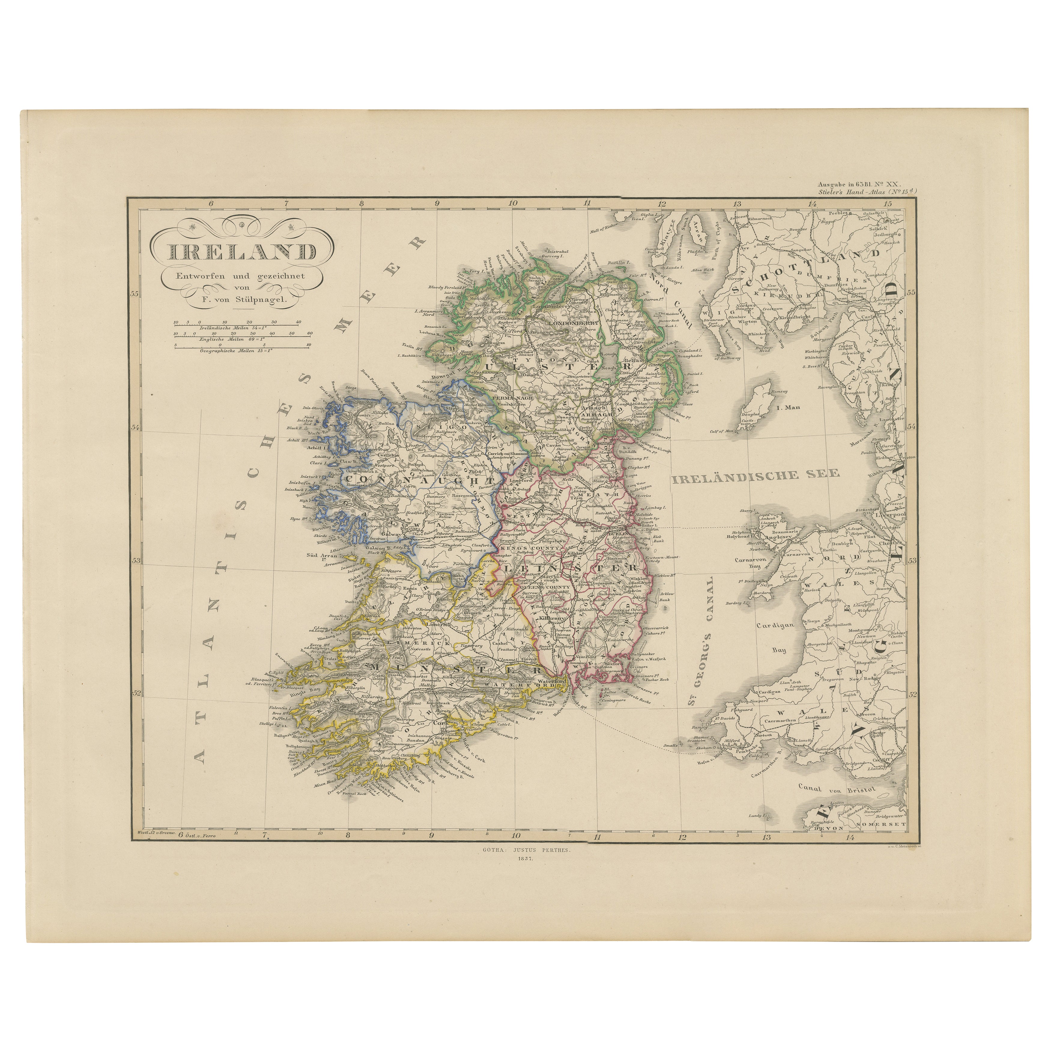
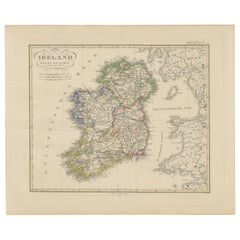
Tout afficherCarte de l
Irlande : début du 19e siècle - tirée du Tardieu Atlas de 1802
Description de la carte ancienne
**Titre:** Carte d'Irlande
**Détails de la publication:**
- **Titre de l'atlas:** Nouvel Atlas Universel de Géographie Ancienne et Moderne
- Object...
Catégorie
Antiquités, Début des années 1800, Cartes
Matériaux
Papier

352 € Prix de vente
20 % de remise
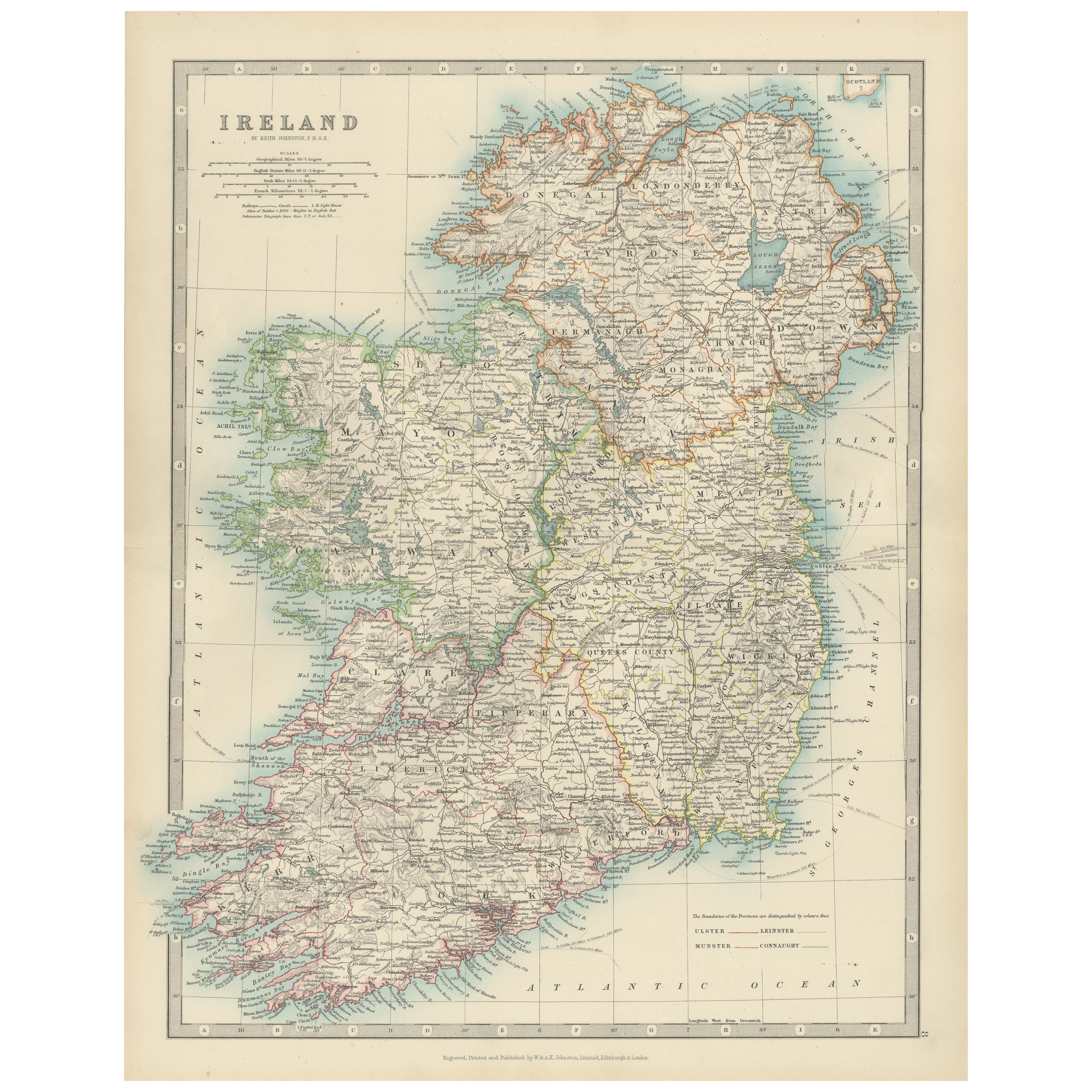
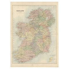
Carte de l
Irlande - Divisions des provinces et des comtés 1851
Carte de l'Irlande - Divisions des provinces et des comtés 1851
Cette belle estampe ancienne représentant l'Irlande, intitulée simplement "Ireland", a été publiée en 1851 par Justus...
Catégorie
Antiquités, Milieu du XIXe siècle, Allemand, Cartes
Matériaux
Papier
Carte ancienne de l
Irlande, 1903, avec les limites complexes des comtés et les détails côtiers
Titre : Carte ancienne de l'Irlande, 1903, avec des limites de comtés complexes et des détails côtiers
Description :
Cette carte ancienne de l'Irlande, gravée et publiée en 1903 par...
Catégorie
Début du 20ème siècle, Cartes
Matériaux
Papier

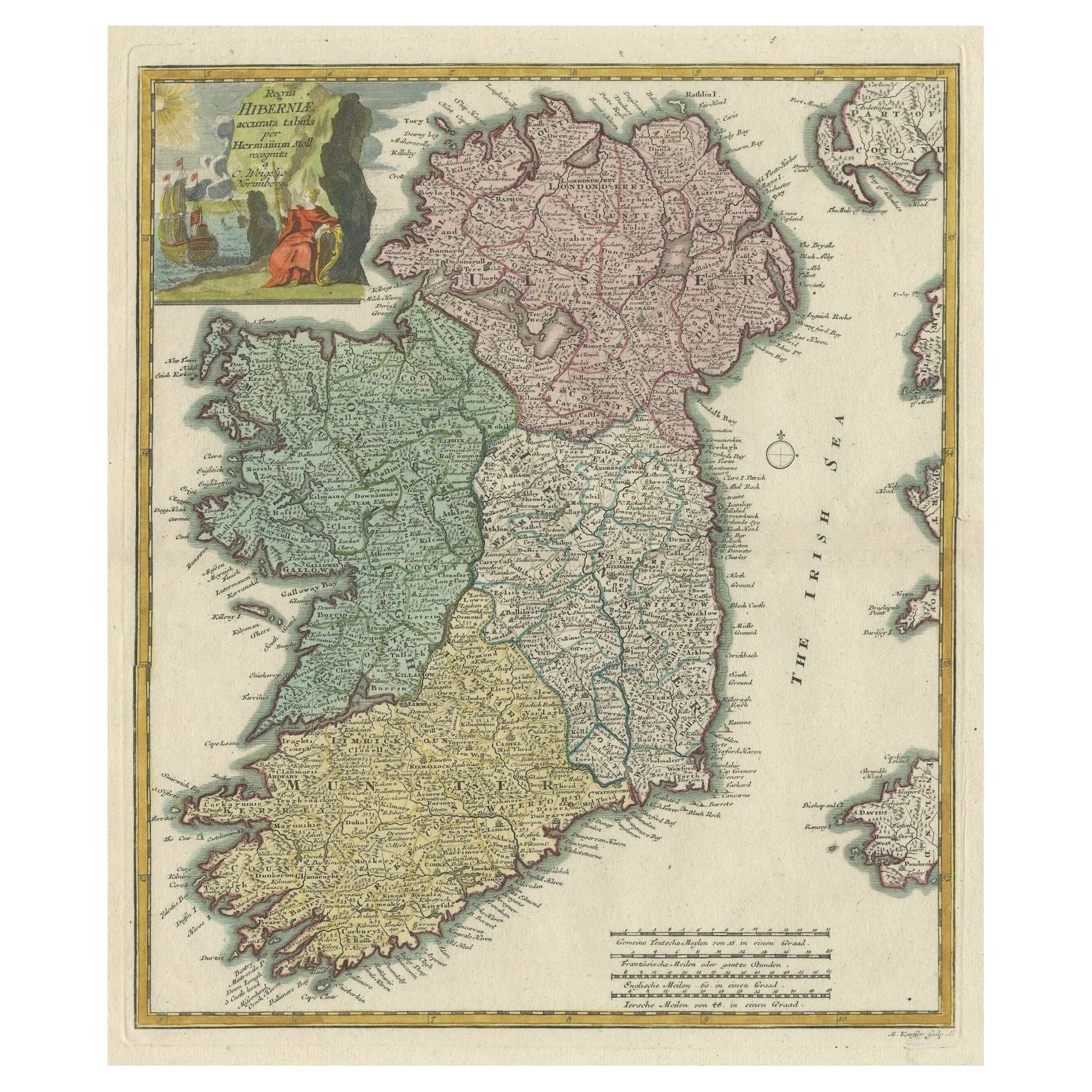
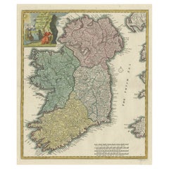
Carte décorative ancienne colorée à la main des quatre provinces irlandaises, Irlande, vers 1718
Titre : Regni Hiberniae Accurata Tabula per Hermanum Moll
Carte décorative des quatre provinces irlandaises, Irlande, 1718, par Christoph Weigel (avec le crédit de Herman Moll), gr...
Catégorie
Antiquités, années 1710, Cartes
Matériaux
Papier
Carte ancienne de l
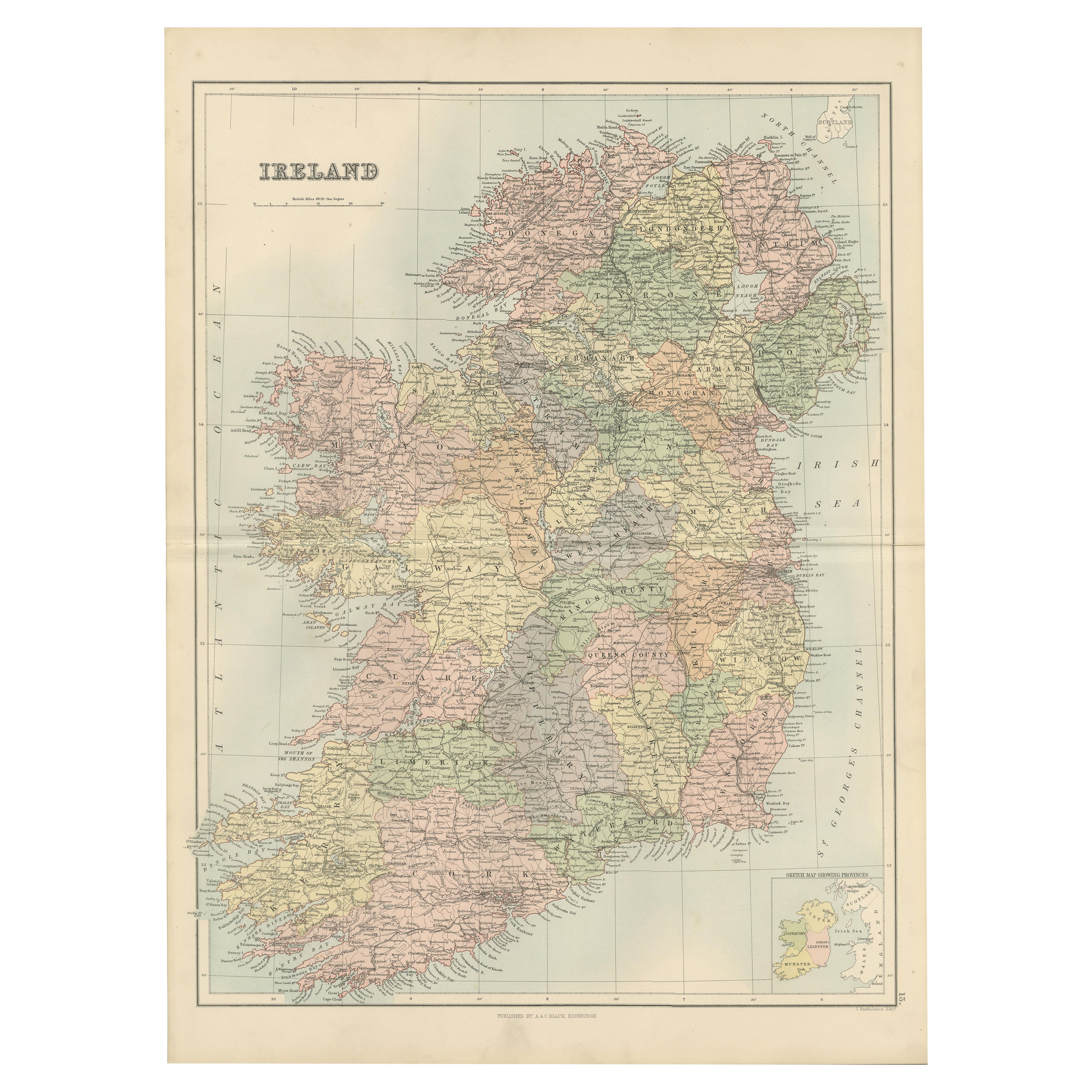
Irlande avec les divisions des comtés - Tableau mural décoratif, 1884
Carte ancienne de l'Irlande avec les comtés - Black's Atlas, 1884
Description :
Cette carte gravée de l'Irlande, finement détaillée, a été publiée dans la nouvelle édition révisée d...
Catégorie
Antiquités, années 1880, Écossais, Cartes
Matériaux
Papier
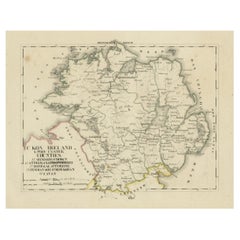
Carte ancienne de 1830 de l
Ulster, Irlande avec Armagh, Down, Antrim, Donegal, Tyrone
Titre : Carte ancienne de 1830 de l'Ulster, Irlande avec Armagh, Down, Antrim, Donegal, et Tyrone
Description : Cette carte de 1830 en langue allemande, intitulée Britisches Rei...
Catégorie
Antiquités, années 1830, Cartes
Matériaux
Papier
Suggestions
Grande carte ancienne originale de l
Irlande. C.1900
Fabuleuse carte de l'Irlande
Couleur originale.
Gravé et imprimé par la George F. Crams Company, Indianapolis.
Publié, C.C.C..
Non encadré.
Livraison gratuite.
Catégorie
Antiquités, années 1890, Américain, Cartes
Matériaux
Papier

Carte ancienne d
Irlande- Kerry. C.1840
Excellente carte du Kerry
Gravure sur acier
Dessiné sous la Directional de A.Adlard
Publié par How and Parsons, C.C. 1840
Non encadré.
Catégorie
Antiquités, années 1840, Anglais, Cartes
Matériaux
Papier

Carte ancienne originale d
Irlande- Tipperary et Waterford. C.1840
Grande carte de Tipperary et Waterford
Gravure sur acier
Dessiné sous la direction de A.Adlard.
Publié par How et Parsons, C.1840.
Non encadré.
Catégorie
Antiquités, années 1840, Anglais, Cartes
Matériaux
Papier

Irlande du Sud-Est : Carte du XVIIe siècle colorée à la main par Mercator et Hondius
Par Gerard Mercator
Carte du XVIIe siècle, gravée sur cuivre et coloriée à la main, intitulée "The Second Table of Ireland, Udrone" par Gerard Mercator et Jodocus Hondius, publiée à Amsterdam en 1635 da...
Catégorie
Antiquités, Milieu du XVIIe siècle, Néerlandais, Cartes
Matériaux
Papier

467 € Prix de vente
20 % de remise
Angleterre, Écosse et Irlande : une carte colorée à la main de la Grande-Bretagne par Tirion
Par Isaak Tirion
Il s'agit d'une carte double page sur cuivre, colorée à la main, de la Grande-Bretagne intitulée "Nieuwe Kaart van de Eilanden van Groot Brittannien Behelzende de Koningryken Engelan...
Catégorie
Antiquités, Milieu du XVIIIe siècle, Néerlandais, Cartes
Matériaux
Papier

605 € Prix de vente
20 % de remise
Sud-est de l
Irlande : Une carte du 17e siècle coloriée à la main par Mercator et Hondius
Par Gerard Mercator
Carte du XVIIe siècle coloriée à la main sur cuivre et intitulée "The Second Table of Ireland, Udrone" par Gerard Mercator et Jodocus Hondius, publi...
Catégorie
années 1630, Estampes - Paysage
Matériaux
Gravure

467 € Prix de vente
20 % de remise