Items Similar to 18th Century Map of Rome
Surrounding Vicinity


Want more images or videos?
Request additional images or videos from the seller
1 of 15
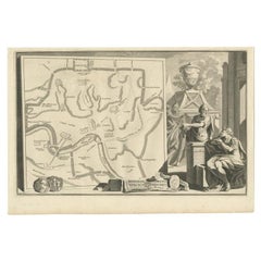
18th Century Map of Rome
Surrounding Vicinity
$17,980
£13,691.76
€15,635.11
CA$25,264.12
A$27,719.55
CHF 14,601.33
MX$329,753.33
NOK 187,041.27
SEK 170,794.22
DKK 116,809.35
About the Item
Intriguing framed map of Rome and the surrounding vicinity featuring detailed cartography, ornamental illustrations, and text index at the bottom. A great, historical conversation piece.
- Dimensions:Height: 52 in (132.08 cm)Width: 83.25 in (211.46 cm)Depth: 1 in (2.54 cm)
- Materials and Techniques:
- Place of Origin:
- Period:
- Date of Manufacture:18th century
- Condition:Wear consistent with age and use. Minor fading. Discoloration mostly on edges do to age and moisture.
- Seller Location:New Orleans, LA
- Reference Number:Seller: ATN263101stDibs: LU887944772352
About the Seller
5.0
Vetted Professional Seller
Every seller passes strict standards for authenticity and reliability
Established in 1994
1stDibs seller since 2010
189 sales on 1stDibs
Typical response time: 3 hours
- ShippingRetrieving quote...Shipping from: High Point, NC
- Return Policy
More From This Seller
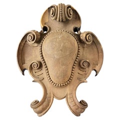
View All19th Century French Large Wooden Antique Fragment from a Chateau
Located in New Orleans, LA
This grand 19th century French wooden fragment, originally from a château, is carved in the form of an ornate, scrolled cartouche —an architectural relic that captures the romantic g...
Category
Antique 19th Century French Architectural Elements
Materials
Wood
18th Century Louis XVI Set of 5 Live Book Boxes
Located in New Orleans, LA
A set of wooden boxes designed to resemble leather-bound books offers a clever and decorative storage solution. Crafted with detailed spines and faux-leather finishes, these boxes bl...
Category
Antique 18th Century French Decorative Boxes
Materials
Leather, Wood

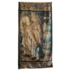
Flemish 18th Century Figural Tapestry
Located in New Orleans, LA
This Flemish 18th Century tapestry features a man and woman in a landscape setting with a floral border above and below. Frayed edges and losses in fabric indicate age. Unusual size ...
Category
Antique 18th Century Belgian Tapestries
Materials
Thread
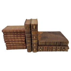
Set of 13 18th/19th Century French Leather Bound Books
Located in New Orleans, LA
A lovely of antique leather bound books. They range in size from 8X10X2 (4) to 5X7X1 (8)
Category
Antique 19th Century French Books
Materials
Paper
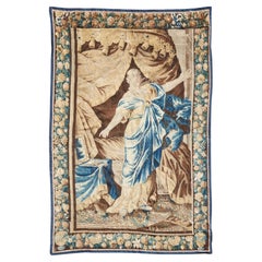
17th Century Flemish Baroque Tapestry
Located in New Orleans, LA
This larger than life tapestry is simply breathtaking. The baroque scene is depicted in woven hues of vibrant blue and soft neutrals. Standing at the grand height of eight feet eleve...
Category
Antique 17th Century Belgian Baroque Tapestries
Materials
Fabric
17th Century Flemish Baroque Tapestry
Located in New Orleans, LA
A 17th Century Flemish Baroque tapestry with
Dramatic composition and movement –The central figure is in a dynamic pose with flowing draperies, and strong diagonals to convey action...
Category
Antique 17th Century Belgian Baroque Tapestries
Materials
Wool

You May Also Like
Framed 17th Century Map of Cumberland, England by John Speed, 1610
By John Speed
Located in Middleburg, VA
A fascinating and richly detailed antique map of Cumberland County in northwest England, drawn and published by the celebrated English cartographer John Spe...
Category
Antique Early 17th Century English British Colonial Maps
Materials
Copper, Gold Leaf

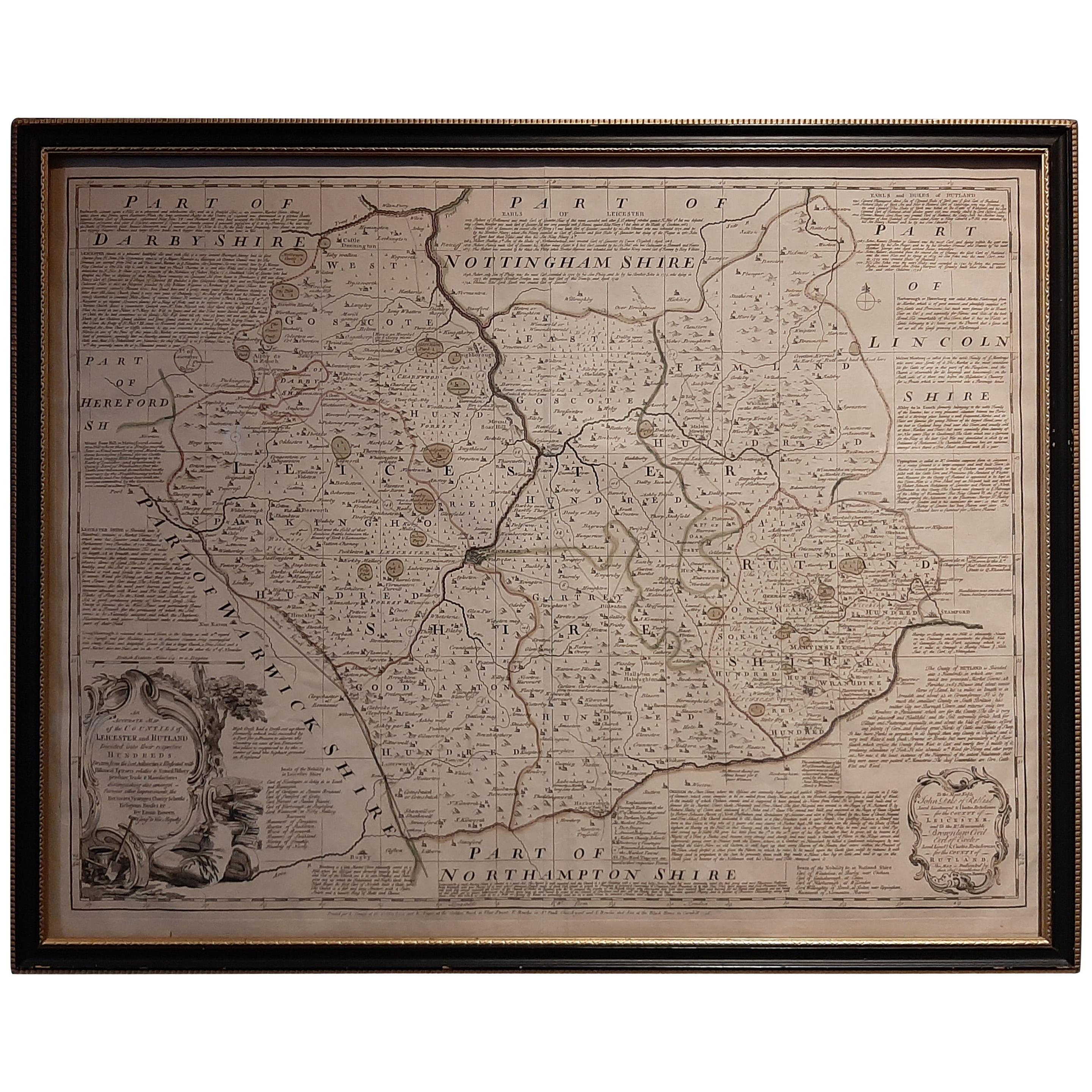
Antique Map of Leicester and Rutland by Tinney
Sayer,
circa 1756
Located in Langweer, NL
Antique map titled 'An Accurate Map of the Counties of Leicester and Rutland (..)'. Large map of Leicester and Rutland with dedications to the Most Noble John Duke of Rutland, and to...
Category
Antique Mid-18th Century Maps
Materials
Paper

$765 Sale Price
20% Off
Antique Map of Asia
in Frame, circa 1739
Located in Langweer, NL
Antique map titled 'Asia Dividida em suas Regioens & Principaes Estados'. Rare and uncommon map of Asia. Signed '1739'. Source unknown, to be determined.
...
Category
Antique Mid-18th Century Maps
Materials
Paper

$622 Sale Price
35% Off
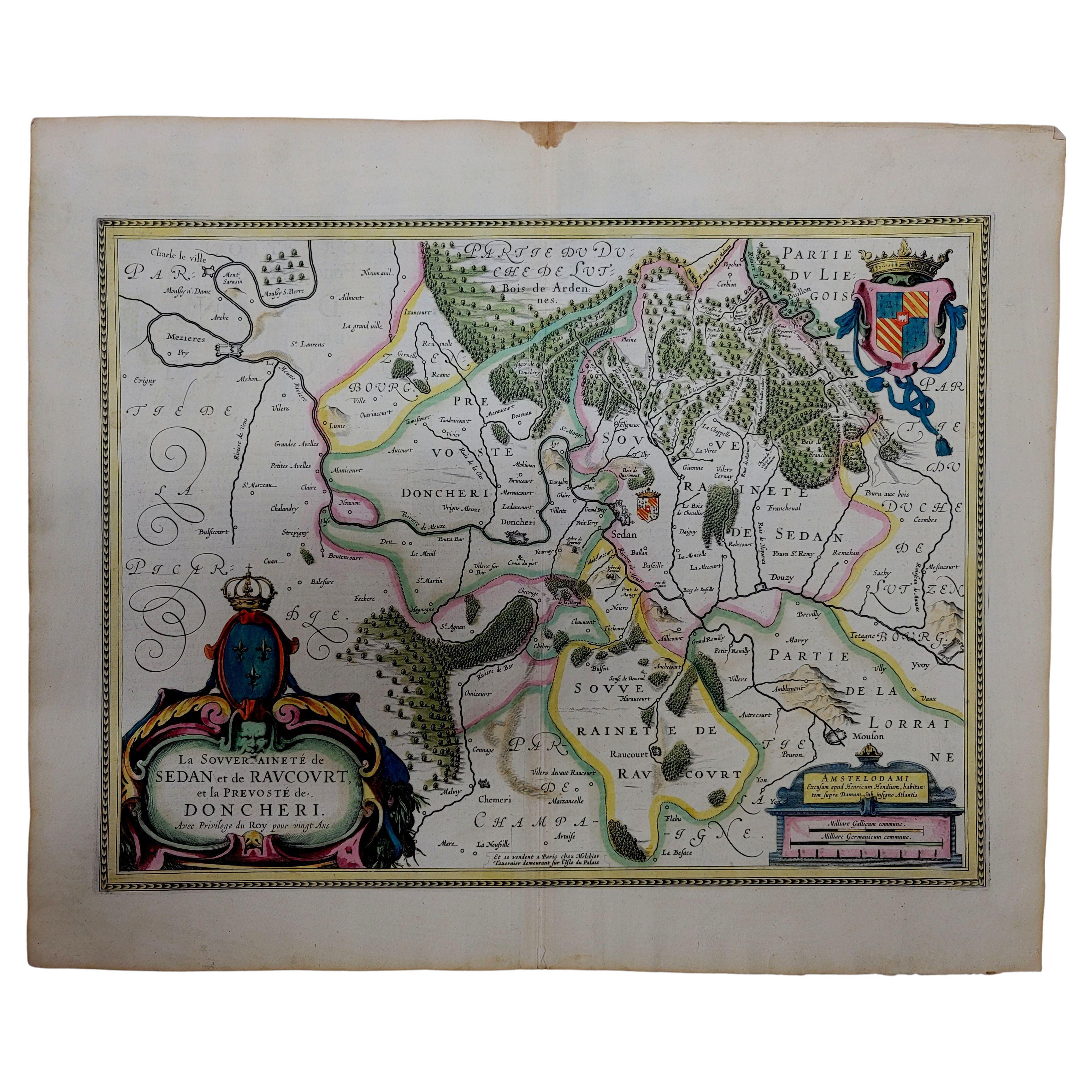
1633 Map "La Souverainete De Sedan Et De Raucourt, Et La Prevoste Ric0011
Located in Norton, MA
1653 map entitled
"La Souverainete de Sedan et de Raucourt, et la Prevoste de Doncheri,"
Ric0011
Description:
Lovely map centered on Sedan and Doncheri and the Meuze River fr...
Category
Antique 17th Century Dutch Maps
Materials
Paper

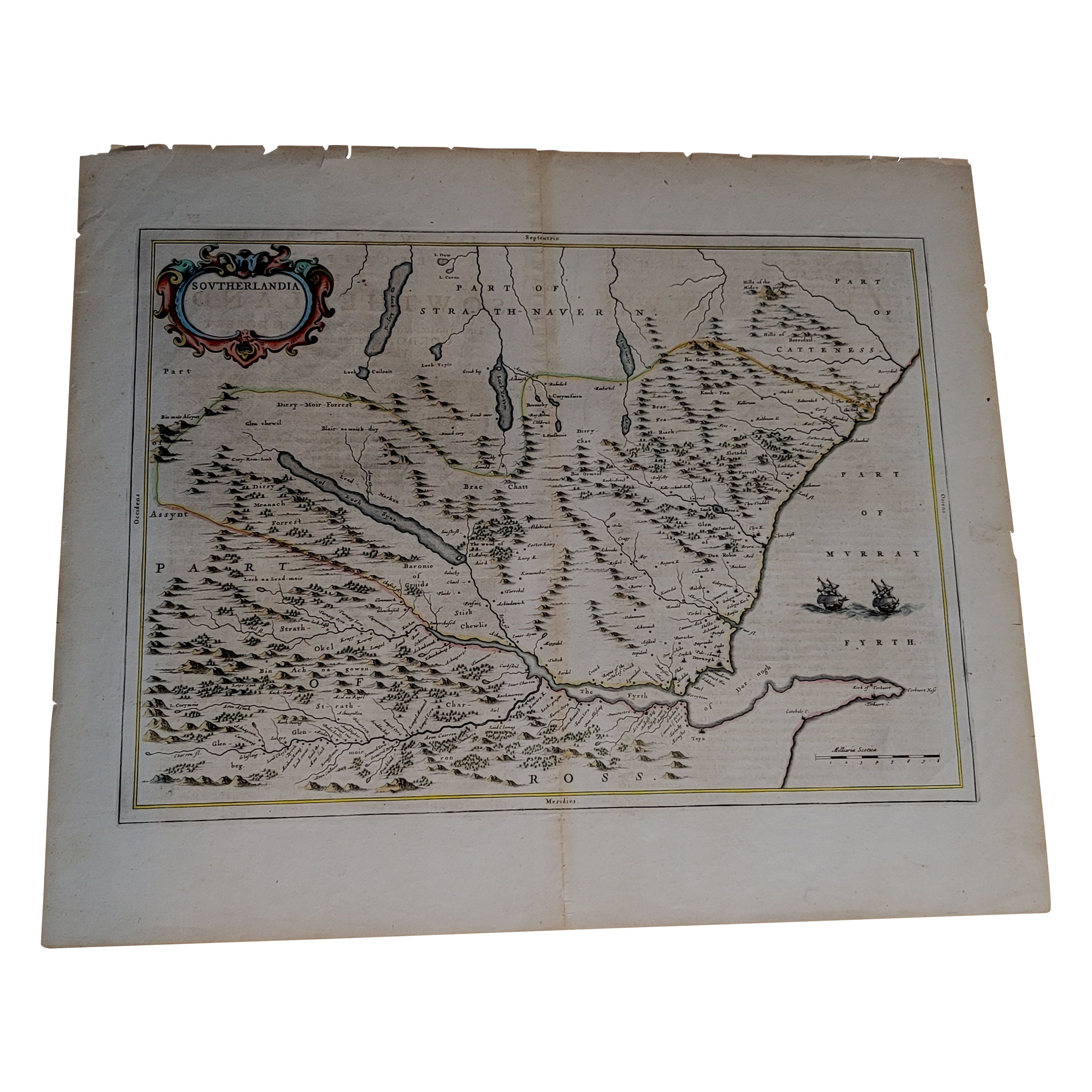
1654 Joan Blaeu Map the Sutherland, Scotland, Entitled "Southerlandia, "Ric0007
Located in Norton, MA
1654 Joan Blaeu map of the
Sutherland, Scotland, entitled
"Southerlandia,"
Hand Colored
Ric0007
Description:
Lovely map centered on Sedan and D...
Category
Antique 17th Century Dutch Maps
Materials
Paper

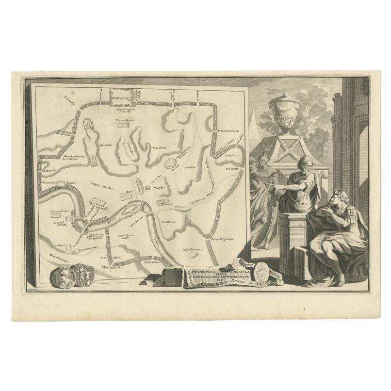
Old Map of Ancient Rome Illustrating Major Monuments and the Seven Hills, c.1704
Located in Langweer, NL
Antique map Rome titled 'Omnia Romanae cedant Miracula Terrae (..)'. Map of Ancient Rome Illustrating Major Monuments and the Seven Hills. This map or...
Category
Antique 18th Century Maps
Materials
Paper
More Ways To Browse
Antique Maps Of Italy
Lamps
Mid Century Modern Office Furniture
Bamboo Or Wicker Chairs
Used Modern Office Furniture
Rattan Or Wicker Chairs
Used Bar Furniture
Antique Office Furniture
Arabian Or Moorish Chairs
Used Bars Furniture
Living Room Lamp
Hand Knotted Rugs
Vintage United Furniture
Used Carpets
T
Mid Century Lighting
Italian Mid Century
Italian Mid Century Modern Furniture