1 of 4
Irish Blunderbus by Trulock of Dublin
$4,783.45List Price
About the Item
- Creator:Trulock (Maker)
- Dimensions:Height: 6.5 in (16.51 cm)Width: 31.5 in (80.01 cm)Depth: 2.75 in (6.99 cm)
- Place of Origin:Ireland, Republic of
- Period:
- Date of Manufacture:circa 1845
- Condition:Wear consistent with age and use.
- Seller Location:Bransby, GB
- Reference Number:1stDibs: LU4129112335411
Authenticity Guarantee
In the unlikely event there’s an issue with an item’s authenticity, contact us within 1 year for a full refund. DetailsMoney-Back Guarantee
If your item is not as described, is damaged in transit, or does not arrive, contact us within 7 days for a full refund. Details24-Hour Cancellation
You have a 24-hour grace period in which to reconsider your purchase, with no questions asked.Vetted Professional Sellers
Our world-class sellers must adhere to strict standards for service and quality, maintaining the integrity of our listings.Price-Match Guarantee
If you find that a seller listed the same item for a lower price elsewhere, we’ll match it.Trusted Global Delivery
Our best-in-class carrier network provides specialized shipping options worldwide, including custom delivery.You May Also Like
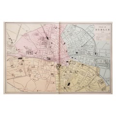
Large Original Antique City Plan of Dublin, Ireland, circa 1880
Located in St Annes, Lancashire
Great city plan of Dublin
Published circa 1880
Unframed
Free shipping.
.
Category
Antique 1880s Scottish Maps
Materials
Paper
$90
Free Shipping
H 13.5 in W 20 in D 0.07 in
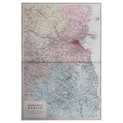
Large Original Antique Map of The Environs of Dublin, Ireland, circa 1880
Located in St Annes, Lancashire
Great map of The Environs of Dublin
Published circa 1880
Unframed
Free shipping.
Category
Antique 1880s Scottish Maps
Materials
Paper
$90
Free Shipping
H 20 in W 13.5 in D 0.07 in
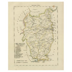
Antique 1830 Map of Leinster, Ireland with Dublin, Kilkenny, Wexford and Kildare
Located in Langweer, NL
Title: Antique 1830 Map of Leinster, Ireland with Dublin, Kilkenny, Wexford, and Kildare
Description: This 1830 German-language map, titled Britisches Reich – C. Kon: Ireland, f...
Category
Antique 1830s Maps
Materials
Paper
$406
H 12.88 in W 10.44 in D 0.01 in
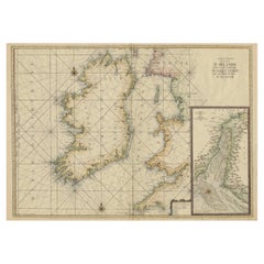
Large 1693 Maritime Map of Irish Sea, West Coasts of Ireland, England, Scotland
Located in Langweer, NL
This large late-17th-century sea chart is titled *Carte Générale des Costes d’Irlande, et des Costes Occidentales d’Angleterre avec une Partie de celles d’Ecosse*, showing the entire...
Category
Antique 1690s French Maps
Materials
Paper
$2,331 Sale Price
25% Off
H 24.81 in W 37.01 in D 0.01 in
Antique Map of England and Ireland by Lattre, 1789
Located in Langweer, NL
Antique map titled 'Les Royaumes d'Angleterre d'Ecosse et d'Irlande'. Original antique map of England and Ireland. Originates from 'Petit Atlas ...
Category
Antique 18th Century Maps
Materials
Paper

Antique Map of New Ireland, 1774
Located in Langweer, NL
Antique print titled 'Neu Irrland (..)'. Antique map of New Ireland with 7 coastal profiles, Papua New Guinea. Originates from 'Geschichte der See-Reisen u...
Category
Antique 18th Century German Maps
Materials
Paper

Decorative Hand-Coloured Antique Map of the Four Irish Provinces, Ireland, c1718
Located in Langweer, NL
Title: Regni Hiberniae Accurata Tabula per Hermanum Moll
Decorative map of the four Irish provinces, Ireland, 1718, by Christoph Weigel (with credit to Herman Moll), engraved by Mi...
Category
Antique 1710s Maps
Materials
Paper
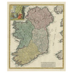
$1,016
H 20.08 in W 15.75 in D 0 in
Large Original Antique Map of Ireland. C.1900
Located in St Annes, Lancashire
Fabulous map of Ireland
Original color.
Engraved and printed by the George F. Cram Company, Indianapolis.
Published, C.1900.
Unframed.
Free shipping.
Category
Antique 1890s American Maps
Materials
Paper

Original Antique Map of Ireland- Kerry. C.1840
Located in St Annes, Lancashire
Great map of Kerry
Steel engraving
Drawn under the direction of A.Adlard
Published by How and Parsons, C.1840
Unframed.
Category
Antique 1840s English Maps
Materials
Paper

In The Houses of Ireland, First Edition
By Walter Pfeiffer (b.1886), Marianne Heron
Located in valatie, NY
In The Houses of Ireland by Walter Pfeiffer and Marianne Heron. New York: Stewart, Tabori and Chang, Inc., 1988. First edition hardcover with dust jacket. 254 pp. A beautiful chronic...
Category
20th Century American Books
Materials
Paper

Still Thinking About These?
All Recently ViewedMore Ways To Browse
Antique Blunderbuss
Vintage Acupuncture Posters
Vintage Wooden Ammunition Box
Antique Mace
Lantaka Cannon
Antique Handcuff
Estwing Hammer Vintage
Estwing Hammers Used
Indian Katar
Rifle Scabbard
16th Century Dagger
Antique Battle Shield
Antique Firearms
Antique Handcuff Keys
Antique Short Sword
Bridge On The River Kwai
English Cordite Bucket
Scottish Sword