1 of 6
1930s French Propeller by Hélice Levasseur
$5,911.37List Price
About the Item
- Dimensions:Height: 47.2 in (119.89 cm)Width: 6.2 in (15.75 cm)Depth: 2.7 in (6.86 cm)
- Materials and Techniques:
- Place of Origin:
- Period:
- Date of Manufacture:1930s
- Condition:Wear consistent with age and use.
- Seller Location:Raalte, NL
- Reference Number:1stDibs: LU2724311933903
Authenticity Guarantee
In the unlikely event there’s an issue with an item’s authenticity, contact us within 1 year for a full refund. DetailsMoney-Back Guarantee
If your item is not as described, is damaged in transit, or does not arrive, contact us within 7 days for a full refund. Details24-Hour Cancellation
You have a 24-hour grace period in which to reconsider your purchase, with no questions asked.Vetted Professional Sellers
Our world-class sellers must adhere to strict standards for service and quality, maintaining the integrity of our listings.Price-Match Guarantee
If you find that a seller listed the same item for a lower price elsewhere, we’ll match it.Trusted Global Delivery
Our best-in-class carrier network provides specialized shipping options worldwide, including custom delivery.You May Also Like
Art Deco Weather Station made from a Wooden Airplane Propeller, 1930s
Located in Esbjerg, DK
Unusual, sculptural and one of a kind weather station made from the center-piece of a large wooden airplane propeller. It was professionally re-purposed by hand in Denmark during the...
Category
Vintage 1930s Danish Art Deco Aviation Objects
Materials
Brass
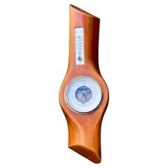
$1,785
H 29.14 in W 8.67 in D 3.94 in
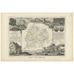
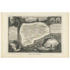
Antique Map of Cantal ‘France’ by V. Levasseur, 1854
By Victor Levasseur
Located in Langweer, NL
Antique map titled 'Dépt. du Cantal'. Map of the French department of Cantal, France. This area of France is known for its production of Cantal, a firm cheese, named after the region...
Category
Antique Mid-19th Century Maps
Materials
Paper
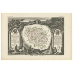
Antique Map of Creuse ‘France’ by V. Levasseur, 1854
By Victor Levasseur
Located in Langweer, NL
Antique map titled 'Dépt. de la Creuse'. Map of the French department of Creuse, France. This region is well known for its apple cider made from Limousin apples and its international...
Category
Antique Mid-19th Century Maps
Materials
Paper
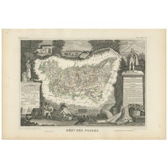
Antique Map of Vosges ‘France’ by V. Levasseur, 1854
By Victor Levasseur
Located in Langweer, NL
Antique map titled 'Dépt. des Vosges'. Map of the Vosges region in France, centred on Epinal. This map originates from ‘Atlas National de la France Illustré’. Published by A. Combett...
Category
Antique Mid-19th Century Maps
Materials
Paper
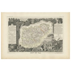
Antique Map of Var
France
by V. Levasseur, 1854
By Victor Levasseur
Located in Langweer, NL
Antique map titled 'Dépt. du Var'. Map of the French department of Var, the heart of the French Riviera or Côte d'Azur. Includes the resort cities of Cannes, Nice and San Tropez...
Category
Antique Mid-19th Century Maps
Materials
Paper
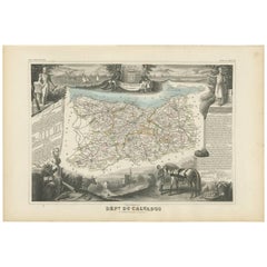
Antique Map of Calvados ‘France’ by V. Levasseur, 1854
By Victor Levasseur
Located in Langweer, NL
Antique map titled 'Dépt. du Calvados'. Map of the French department of Calvados, France. This area of France is known for its production of Calvados, the world's fines apple brandy....
Category
Antique Mid-19th Century Maps
Materials
Paper
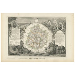
Antique Map of Sarthe
France
by V. Levasseur, 1854
By Victor Levasseur
Located in Langweer, NL
Antique map titled 'Dépt. de la Sarthe'. The north-west France Department of Sarthe is in the Pays de la Loire region of Le Mans, the location of the great endurance sports car road-...
Category
Antique Mid-19th Century Maps
Materials
Paper
Antique Map of Doubs ‘France’ by V. Levasseur, 1854
By Victor Levasseur
Located in Langweer, NL
Antique map titled 'Dépt. du Doubs'. Map of the French department of Doubs, France. The whole is surrounded by elaborate decorative engravings designed to illustrate both the natural...
Category
Antique Mid-19th Century Maps
Materials
Paper
Antique Map of Oise ‘France’ by V. Levasseur, 1854
By Victor Levasseur
Located in Langweer, NL
Antique map titled 'Dépt. de l'Oise'. Map of the French department of Oise, France. The map is surrounded by elaborate decorative engravings designed to illustrate both the natural b...
Category
Antique Mid-19th Century Maps
Materials
Paper

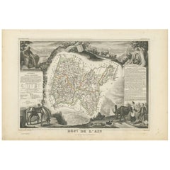
Antique Map of Ain ‘France’ by V. Levasseur, 1854
By Victor Levasseur
Located in Langweer, NL
Antique map titled 'Dépt. de l'Ain'. Map of the French department of l'Ain, France. This area of France is known for its Bugey wines, which are generally aromatic and white. It is al...
Category
Antique Mid-19th Century Maps
Materials
Paper