Want more images or videos?
Request additional images or videos from the seller
1 of 5
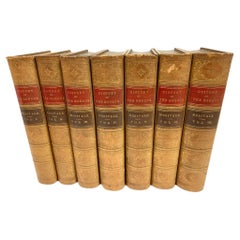
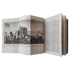
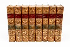
8 Vols. Edward Gibbon. The Decline and Fall of The Roman Empire...
$2,500List Priceper set
About the Item
- Dimensions:Height: 5 in (12.7 cm)Width: 5 in (12.7 cm)Depth: 1.25 in (3.18 cm)
- Sold As:Set of 8
- Materials and Techniques:
- Place of Origin:
- Period:
- Date of Manufacture:1900
- Condition:Wear consistent with age and use.
- Seller Location:New York, NY
- Reference Number:1stDibs: LU856145419232
About the Seller
5.0
Recognized Seller
These prestigious sellers are industry leaders and represent the highest echelon for item quality and design.
Established in 1989
1stDibs seller since 2008
186 sales on 1stDibs
Typical response time: 1 hour
Associations
The Art and Antique Dealers League of AmericaAntiques Associations Members
Authenticity Guarantee
In the unlikely event there’s an issue with an item’s authenticity, contact us within 1 year for a full refund. DetailsMoney-Back Guarantee
If your item is not as described, is damaged in transit, or does not arrive, contact us within 7 days for a full refund. Details24-Hour Cancellation
You have a 24-hour grace period in which to reconsider your purchase, with no questions asked.Vetted Professional Sellers
Our world-class sellers must adhere to strict standards for service and quality, maintaining the integrity of our listings.Price-Match Guarantee
If you find that a seller listed the same item for a lower price elsewhere, we’ll match it.Trusted Global Delivery
Our best-in-class carrier network provides specialized shipping options worldwide, including custom delivery.You May Also Like
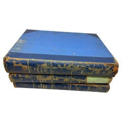
7 Vol. Set- Charles Merivale, A History Of The Romans Under The Empire, 1858
Located in Bridgeport, CT
London, Longman, Brown, Green, Longmans, & Roberts, various publishing dates. Bound in tan leather with red and brown with gilt spines. Marbelized end papers. All with bookplates ins...
Category
Antique 19th Century English Victorian Books
Materials
Leather, Paper
$1,320 / set
H 8.75 in W 6 in D 1.75 in
The ILLUSTRATED LONDON NEWS 1954 Vol 2 and 1956 Vol 1 Vol 2 Set of 3 Books
Located in Moreno Valley, CA
The ILLUSTRATED LONDON NEWS 1954 Vol 2 and 1956 Vol 1 Vol 2 Set of 3 Books.
Each book stamped: "Malcolm Forbes Esqu." see picture attached.
Probably from the estate of the Library of...
Category
Mid-20th Century English Victorian Books
Materials
Paper
$495 / set
H 14.5 in W 10 in D 2 in
Waugh, Evelyn, Decline
Fall, 1962-Revised Edition-Presentation Copy !
Located in Hillsborough, NJ
Author: WAUGH, Evelyn
Title: Decline & Fall.
Publisher: London: Chapman & Hall, 1962.
Description: Revised edition with a new preface and a presentation copy. 1 vol., illustrated with plates after Waugh, inscribed on the front blank endleaf "For Patrick [Balfour] with regards from Evelyn", publisher's original gilt lettered blue cloth binding, with the DJ, not price clipped.
Condition: Minor foxing to endleaves otherwise NEAR FINE/VG.
Provenance: Patrick Balfour, 3rd Baron Kinross (1904-1976). Evelyn and Patrick first met at Oxford in the early 1920s, and later in that decade were members of the social set known as The Bright Young Things...
Category
Vintage 1960s British Books
Materials
Fabric
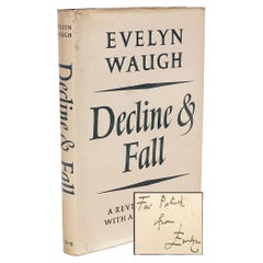
$6,900
H 8.5 in W 5.5 in D 0.75 in
Antique Map of The Regions of Italy and Sicily during the Roman Empire, 1880
Located in Langweer, NL
This map is an original antique engraving titled "ITALIAE REGIONES IIII SICILIA," which translates to "The Regions of Italy and Sicily." This detailed historical map portrays the reg...
Category
Antique 1880s Maps
Materials
Paper

$352 Sale Price
20% Off
Free Shipping
H 18.51 in W 15.56 in D 0 in
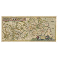
Germany and the Borders of Empire: Bodenehr’s Map of the Holy Roman World, 1710
Located in Langweer, NL
Title:
Germany and Surrounding Realms by Gabriel Bodenehr, circa 1710
This striking copperplate engraving, titled "S. Imperium Romano-Germanicum, Teutschland mit Seinen Angräntzende...
Category
Antique 1710s Maps
Materials
Paper
$453
H 10.24 in W 13.78 in D 0.01 in
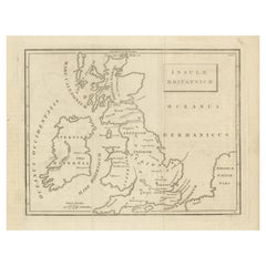
Antique Map of the British Isles According to the Geography of the Roman Empire
Located in Langweer, NL
Antique map titled 'Insulae Britannicae'. Interesting map of Britain, Scotland, and Ireland. It shows a rudimentary outline of the islands according to the geography of the Roman Emp...
Category
Antique Late 18th Century Maps
Materials
Paper
$171 Sale Price
20% Off
H 8.08 in W 10.24 in D 0.02 in
Antique Map of Part of the Roman Empire by H. Kiepert, circa 1870
By Heinrich Kiepert
Located in Langweer, NL
Antique map titled 'Imperia Persarum et Macedonum'. Depicts part of the Roman Empire, from Greece to Eastern India. This map originates from 'Atlas Antiqus. Zwölf Karten zur Alten Ge...
Category
Antique Late 19th Century Maps
Materials
Paper

$178
H 14.38 in W 18.31 in D 0.02 in
Original Map of the Rhine River in the Holy Roman Empire by Janssonius, c.1645
Located in Langweer, NL
This striking original antique map, titled "Rhenus Fluviorum Europae celeberrimus," showcases the historic Rhine River region, a vital artery of European trade, culture, and history....
Category
Antique Mid-17th Century Dutch Maps
Materials
Paper
$1,402 Sale Price
20% Off
H 16.54 in W 37.21 in D 0.01 in
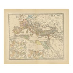
Imperium Romanum: A Detailed Map of the Roman Empire in its Zenith, 1880
Located in Langweer, NL
This original antique map, titled "IMPERIVM ROMANVM", is a detailed depiction of the Roman Empire at the height of its power. The main map encompasses the vast expanse of the Roman territories, stretching from the British Isles in the northwest to the deserts of Arabia and the northern fringes of Africa in the southeast.
**Key Features of the Map:**
1. **Territorial Colors**: The map uses different colors to distinguish the various provinces of the Roman Empire. These color-coded areas are to represent the administrative divisions within the Empire.
2. **Topography**: It shows a considerable amount of topographical detail, with mountain ranges, rivers, and bodies of water such as the Mediterranean Sea, prominently displayed.
3. **Cities and Settlements**: Cities are marked, with symbols indicative of their size or importance. Major cities such as Rome, Constantinople, Alexandria, and Carthage are highlighted.
4. **Road Networks**: There appear to be lines connecting various cities and towns, which could represent the famous Roman road network that facilitated trade and military movements.
5. **Latin Text...
Category
Antique 1880s Maps
Materials
Paper
$352 Sale Price
20% Off
Free Shipping
H 15.56 in W 18.51 in D 0 in
Vol 15 of
The Universal Magazine of Knowledge and Pleasure
by Hinton
1754
Located in Langweer, NL
Vol XV 'The Universal Magazine of Knowledge and Pleasure' by John Hinton, published 1754. The Universal Magazine of Knowledge and Pleasure was a per...
Category
Antique Mid-18th Century Books
Materials
Paper
$763 Sale Price
20% Off
H 8.27 in W 5.71 in D 1.58 in
More From This Seller
View All8 Vol.Edward Gibbon Esq, The History of the Decline and Fall of the Roman Empire
Located in New York, NY
8 Vol. Edward Gibbon Esq., The History of the Decline and Fall of the Roman Empire. Illustrated by G.F. Sargent. Illustrated throughout. Marbled endpapers. Full brown calf levant lea...
Category
Antique 19th Century English Books
Materials
Leather
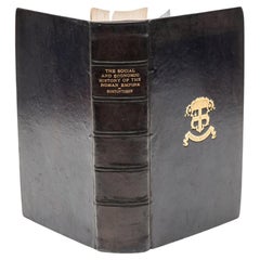
1 Vol. M. Rostovtzeff. The Social
Economic History of The Roman Empire.
Located in New York, NY
1. Vol. M. Rostovtzeff. The Social & Economic History of The Roman Empire. Bound in full blue calf, top edged gilt, raised band, marbled endpapers, illustrated. Published: Oxford, Cl...
Category
20th Century English Books
Materials
Leather
3 Vols. Edward Williams Lane, Arabian Nights
Located in New York, NY
3 Vols. Edward Williams Lane, Arabian Nights. Illustrated, bound in 3/4 red morocco, marbled boards and endpapers, all edged gilt, raised bands, gilt panels. Published: London, Bicke...
Category
Antique 19th Century English Books
Materials
Leather
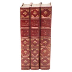
$1,200 / set
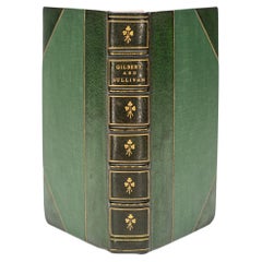
1 Vol. Gilbert and Sullivan. The Complete Plays
Located in New York, NY
1 Vol. Gilbert and Sullivan. The Complete Plays.Bound in 3/4 green morocco, linen boards, top edges gilt, raised bands, gilt panels. Published: New York: The Modern Library, N.D.
Category
20th Century American Books
Materials
Leather
1 Vol. Gilbert and Sullivan. The Complete Plays
Located in New York, NY
1 Vol. Gilbert and Sullivan. The Complete Plays.Bound in 3/4 green morocco, linen boards, top edges gilt, raised bands, gilt panels. Published: New York: The Modern Library, N.D. Cir...
Category
20th Century American Books
Materials
Leather
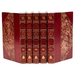
5 Vol. M.A. Thiers, The History of the French Revolution
Located in New York, NY
5 Vol. M.A. Thiers, The History of the French Revolution. Translated with notes and illustrations by Frederick Shoberl. First Edition. Illustrated frontispiece. Illustrated with engr...
Category
20th Century English Books
Materials
Leather
Still Thinking About These?
All Recently ViewedMore Ways To Browse
Vintage Illustrated Maps
Serge Roche Book
Sidney Paget
Steam Truck
Steven Gambrel Furniture
Tamotsu Yagi
The Life Of George Washington By John Marshall
The Village Voice Paper
The Way We Wore
The White House Cookbook
Tiffany 150th Anniversary
U S Grant Memoirs
Versailles Assouline
Vintage Fishing Reel Collection
Vintage Furniture Thornbury
Vintage Neon Sign Art Collectibles
W Rolfe
Walt Doran