Want more images or videos?
Request additional images or videos from the seller
1 of 8
All Round The World: An Illustrated Record of Voyages by Ainsworth, 1868
Price:$478.20
$569.55List Price
About the Item
- Dimensions:Height: 11.82 in (30 cm)Width: 9.06 in (23 cm)Depth: 2.37 in (6 cm)
- Materials and Techniques:
- Period:
- Date of Manufacture:1868
- Condition:Please read description for details.
- Seller Location:Langweer, NL
- Reference Number:Seller: BG-127011stDibs: LU3054321016162
About the Seller
5.0
Recognized Seller
These prestigious sellers are industry leaders and represent the highest echelon for item quality and design.
Platinum Seller
Premium sellers with a 4.7+ rating and 24-hour response times
Established in 2009
1stDibs seller since 2017
2,836 sales on 1stDibs
Typical response time: 1 hour
Authenticity Guarantee
In the unlikely event there’s an issue with an item’s authenticity, contact us within 1 year for a full refund. DetailsMoney-Back Guarantee
If your item is not as described, is damaged in transit, or does not arrive, contact us within 7 days for a full refund. Details24-Hour Cancellation
You have a 24-hour grace period in which to reconsider your purchase, with no questions asked.Vetted Professional Sellers
Our world-class sellers must adhere to strict standards for service and quality, maintaining the integrity of our listings.Price-Match Guarantee
If you find that a seller listed the same item for a lower price elsewhere, we’ll match it.Trusted Global Delivery
Our best-in-class carrier network provides specialized shipping options worldwide, including custom delivery.You May Also Like
1975 World Ceramics: An Illustrated History by Robert J. Charleston
Located in Stamford, CT
World Ceramics: An Illustrated History by Robert J. Charleston. Hardcover 1975, 2nd printing.
Category
Vintage 1970s American Arts and Crafts Books
Materials
Paper

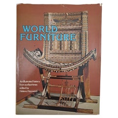
World Furniture an Illustrated History by Helena Hayward 1981
Located in Moreno Valley, CA
World Furniture; an Illustrated History Hardcover by Helena Hayward 1981.
A very large heavy volume designed to provide an illustrated history of furniture throughout the world, fro...
Category
Late 20th Century American Egyptian Revival Books
Materials
Paper
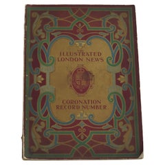
Coronation Record of King George V by The Illustrated London News , London 1911
Located in Lincoln, Lincolnshire
This is an original 1911 edition of the Illustrated London News Coronation Record celebrating the coronation of King George V and Queen Mary.
This Royal Memorabilia magazine publica...
Category
Early 20th Century British Edwardian Historical Memorabilia
Materials
Paper
$300
H 16.2 in W 11.6 in D 0.5 in
An Interesting Account of the Voyages and Travels of Captains Lewis and Clarke
Located in Colorado Springs, CO
Fisher, William. An Interesting Account of the Voyages and Travels of Captains Lewis and Clarke, in the Years 1804-5, & 6... Baltimore: P. Mauro, 1813. 12mo. Illustrated. Rebound in...
Category
Antique 1810s American Federal Books
Materials
Leather, Paper
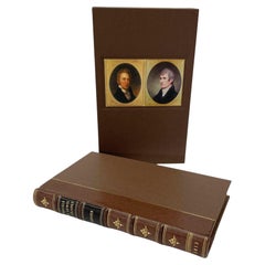
$3,500
H 7.19 in W 4.57 in D 1.19 in
Illustrated History of the World From the Big Bang to the Third Millennium 2001
Located in Moreno Valley, CA
Illustrated History of the World: From the Big Bang to the Third Millennium by Neil Morris Hardcover.Illustrated History of the World. published in 2001.When our earliest human ances...
Category
21st Century and Contemporary American Expressionist Books
Materials
Paper
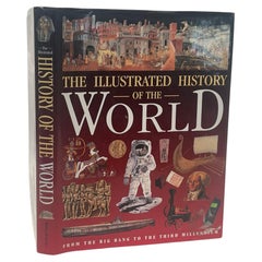
$95
H 11.5 in W 9 in D 1 in
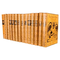
1894-1949 The Yellow Book: An Illustrated Quarterly
By Aubrey Beardsley
Located in Bath, GB
A lovely set of all thirteen volumes of 'The Yellow Book' literary quarterly, published at the end of the nineteenth century, with numerous plates throughout each volume.
Complete a...
Category
Early 20th Century British Books
Materials
Paper
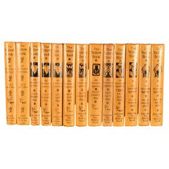
1894-97 The Yellow Book: an Illustrated Quarterly
Located in Bath, GB
A sought after set of all thirteen volumes from the widely celebrated Victorian literary and artistic periodical 'The Yellow Book'.
Complete run of all first edition thirteen volume...
Category
Antique 1890s British Books
Materials
Paper
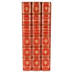
1868 The Moonstone
By Wilkie Collins
Located in Bath, GB
A beautiful first edition set of Wilkie Collin's important sensation mystery novel, very scarce to see a set of all first editions volumes.
The sought after first edition, first sta...
Category
Antique 1860s British Books
Materials
Paper
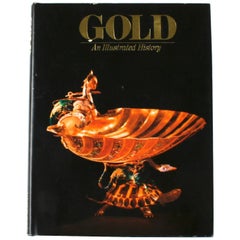
Gold, An Illustrated History, First Edition
By Vincent Buranelli
Located in valatie, NY
Gold, An Illustrated History by Vincent Buranelli. Maplewood: Hammond Incorporated, 1979. First edition hardcover with dust jacket. 221 pp. A book on the history and the love of gold. Illustrated are the masterworks of the Egyptians, Thracians, and Roman and Greek treasures along with masterpieces from the Renaissance. Described are the smugglers, grave robbers, sunken treasures...
Category
20th Century American Books
Materials
Paper
The Ring of the Niblung by Richard Wagner, Illustrated by Arthur Rackham
By Arthur Rackham
Located in Alamo, CA
"The Ring of the Niblung", "The Rhinegold: Prelude; The Valkyrie: First Day of the Trilogy; Siegfried: Second Day of the Trilogy; The Twilight of the Gods: Third Day of the Trilogy" ...
Category
Early 20th Century English Books
Materials
Leather, Paper
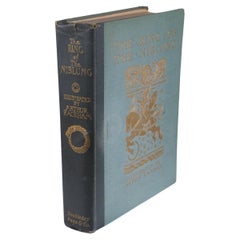
$975
H 10 in W 7.63 in D 1.88 in
More From This Seller
View AllAntique World Map before the Voyages of Christopher Columbus, 1880
Located in Langweer, NL
Antique world map titled 'Monde Connu des Anciens'. Antique map of the World and continents before the voyages of Christopher Columbus. This map originates from 'Géographie Universel...
Category
Antique 19th Century Maps
Materials
Paper
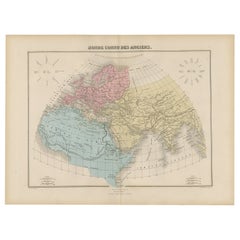
$227 Sale Price
20% Off
Attractive Antique Map of the World as Planisphere, Shows Cook
s Voyages, 1799
Located in Langweer, NL
Antique map titled 'Chart of the World, according to Mercators Projection'. This world map shows the various discoveries of Captain James Cook during his 3 voyages between 1768 and 1780, and the English and French Explorers who followed immediately thereafter, including Vancouver and La Perouse. This edition of the map is significantly revised from the editions issued immediately after the official report of Cook's Voyages were integrated into the map, showing better detail in New Zealand, Australia, the Northwest Coast of America and North East coast of Asia, along with Greenland. A new large lake also appears for the first time in the Western part of North America, shortly before the commencement of the Lewis...
Category
Antique Late 18th Century British Maps
Materials
Paper

$1,334 Sale Price
25% Off
Free Shipping
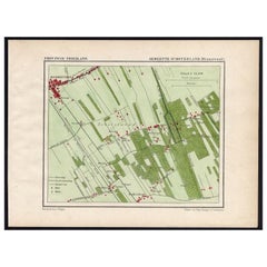
Antique Map of the Region of Oranjewoud by Kuyper, 1868
Located in Langweer, NL
Antique map titled 'Provincie Friesland - Gemeente Schoterland (Oranjewoud)'. Map of the township of Schoterland with a focus on the region of Oranjewoud. This map originates from 'G...
Category
Antique 19th Century Maps
Materials
Paper
Antique Map of the World with California as an Island, 1788
Located in Langweer, NL
Description: Antique map titled 'De wareld in een ronde gedaante van de Noord Pool te zien - De Wareld verbeeld in de gedaante van een hard'. This interesting composition contains three world maps on the sheet. At left is a northern projection showing all the landmasses. At right is a cordiform projection (heart-shaped). At top is a map of the world as known to the ancients. Both the polar and cordiform projections show California as an island...
Category
Antique 1780s Maps
Materials
Paper

Antique Map of Asia by with an Inset Map of Turkey in Asia, 1868
Located in Langweer, NL
Antique map Asia titled 'Carte Politique et Ethnographique d'Asie'. Old map of Asia with an inset map of Turkey in Asia. Includes descriptive text box...
Category
Antique 19th Century Maps
Materials
Paper

Antique Map of the World by Johnson,
1872
Located in Langweer, NL
Antique map titled 'Johnson's World. Original world map. This map originates from 'Johnson's New Illustrated Family Atlas of the World' by A.J. John...
Category
Antique Late 19th Century Maps
Materials
Paper

$444 Sale Price
25% Off
Still Thinking About These?
All Recently ViewedMore Ways To Browse
Charles Dickens Christmas
Cooking Book
David Hicks Living With Design
Ernest Hemingway Furniture
Miniature Book
Miniature Rooms
T E Lawrence
Charlotte Bronte
Dating Antique French Furniture
Edward Fitzgerald
Polaroid Cameras
Taschen Art Edition
Vintage Interior Design Books
Hotel Lambert
J Cooper
J R R Tolkien
Steven Holl
Vellum Books